Pilgrimage to St John’s well Carrigaline, Co. Cork

The 24th of June is the feast of St John the Baptist. This day also coincides with the pagan celebration of mid summer and many pagan traditions continue even down to modern times such as the tradition of lighting bonfires.  There are many holy wells around Ireland dedicated to St John the Baptist and pilgrimage is still undertaken on the saints feast day at a large number of them.

Location Map of St John's well at the edge of Carrigaline town (taken from Google Earth).

Location Map of St John’s well at the edge of Carrigaline town (taken from Google Earth).

On  Sunday  last, St John’s Eve I attended the annual pilgrimage to St John’s well in the town of  Carrigaline, Co Cork. St John’s well or Tobar Eoin Óg  is  located in small wood in the townland of Ballinrea on the outskirts of the town of Carrigaline.  Also attending the  pilgrimage was  Richard Scriven  (Geography UCC)  who is currently doing very interesting PhD research  on modern pilgrimage in Ireland. For more details of Richard’s research check out his blog liminal entwinings.

St John’s Well

The 1st ed Ordnance Survey map of 1840  records the  well as  St Rinoge’s well elsewhere it is called Renogue’s well . Rinoge/Renogue  is likely a corruption of Eoin Óg  the Irish name for the well.

The site consists of  a spring well covered by a corbelled structure, beside the well is a large tree surrounded by a low circular wall with a stone plaque which  provides a short history of the site.

1-DSCF9538

St John’s well

A number of benches are located  at the site and  steps made of railway sleepers make the site more accessible. A small stone altar is located opposite the well.

Lewis’s Topographical Dictionary of Ireland  dating to 1837 gives the following account of the well

At Ballinrea there is a mineral spring, which is considered to be of the same kind as that of Tunbridge Wells, and has been found efficacious in cases of debility; and near it is a holy well, dedicated to St Renogue, which is resorted to by the country people on the 24th of June.

The Carrigaline Parish websites states that

According to tradition the well was discovered by a blind man whose sight was restored. In gratitude he built the beehive shaped stone surround, which can be still seen today.

It is recorded that in the early 19th century huge crowds  of people attended a  patron/pattern day  on St  John’s Eve (23th June) at the well.

According to the plaque at the well, the water  has healing powers and it is customary for pilgrims to say a decade of the rosary at each of the inscribed crosses  that are found in the walls of the well house. The practice of incising crosses is seen at many other pilgrim site such as St Declan’s well at Ardmore, Co Waterford and the practice seems to be a post medieval and  modern tradition.

1-DSCF9502

Well house showing one of the incised pilgrim cross over the door of the well.

Modern Pilgrimage on St John’s Eve

It is an annual tradition for the people of Carrigaline and the surrounding area to visit St Johns well on the eve of the saints feast.  It’s a tradition which likely goes back generations.  Pilgrimage in 2013 began with pilgrims  gathered on the Ballintrea road close to the Dun Eoin housing estate  at 7.15 pm.  People stood around and  chatted and waited for others to arrive. When a crowd had gathered at 7.30 the Carrigaline  pipe band  began a processional walk to the well. The band was immediately  followed by the  parish priest who was then followed by the rest of the people ( pilgrims). The Procession headed along a lane way with a signpost for the well, past some house,  then on to a grassy lane which leads down into a grove of trees. The band played throughout the procession and were really excellent.

009-DSCF9326 (1)

The Carrigaline Pipe Band heading the procession to St John’s well.

039-DSCF9342 (1)

Pilgrims in procession to the well

The walk  was very pleasant and took about 5-10 minutes to complete.  When we all arrived at the well the band took a well deserved brake  and lines up beside the alter. The rest of the people assembled around the clearing facing the stone alter opposite the holy well . There were  two priest from the parish of Carrigaline present to lead the prayers.

1-DSCF9435

The prayers began with the  sorrowful mysteries (five decades of the rosary an explanation of rosary is in the references below).  The parish priest lead the prayers  and  moved around the well clockwise, in the same manner as any pilgrim visiting the well to perform the stations would do.

128-DSCF9389

The a cross was incised with a small stone at each of the crosses around the well.

When each decade of the rosary is begun the pilgrim takes a stone and  scratches a cross into the incised  stone.

1-DSCF9524

Pilgrim incising cross on one of the stones

These stones five in total are located around the well and have deeply incised crosses. The crosses have been created by generations of pilgrims who visited the well.

1-DSCF9534

Cross incised by pilgrims at back of the well

Following the rounds of the well  there was a ceremony called Benediction of the Blessed Sacrament  for those of you who don’t know  what that is it is a devotional ceremony, the sacrament (host) is displayed in a monstrance  in this case  on the small stone altar opposite the well.  The  a priest blesses the congregation with the Eucharist at the end of a period of  prayer.

113-DSCF9381 (1)

A number of  hymns were sung by the choir and played by the pipe band such as ‘Faith of our Fathers’. When the ceremony finished  many of those present lined up and took water from the well. Some of them incised the cross over the well door. Unlike other sites people didn’t seem to bring water bottles with them.

300-DSCF9482 (1)

I returned to the well the following morning,  to see what it was like without the hustle and bustle of people.   It really is one of the most beautiful wells I have visited and so peaceful with lots of singing of the birds.

References

http://www.carrigalineparish.ie/index.php/parishhistory/

http://www.carrigalineparish.ie/index.php/parishhistory/

http://en.wikipedia.org/wiki/Benediction_of_the_Blessed_Sacrament

http://en.wikipedia.org/wiki/Rosary

St Colmcille’s well Disert Donegal

Today is the feast day of St Colmcille who along with St Patrick and St Brigit he is one of the three patron saints of Ireland. In 2008  my good friend Fiona Beglane  brought me to  see  a holy well  associated with the saint. The well in question is located   in the townland of Disert, in the parish of Inver, in Co Donegal. Over the last few years I have been to a lot of pilgrim sites but  this is  one of the most beautiful place  that I have spent time.

Location

St Colmcille’s well  is situated in rough pasture at  the foothill of the  Carnaween hill and the Bluestack  mountains close to the banks of  the Eanybeg river.  As you can see from the photo below this is  the most glorious of  locations.

26-RIMG1175

The site consists of a holy well located close to a small graveyard that is surrounded by a stone wall and the remains of  megalith and associated enclosure.   All three  monuments  are points in  the pilgrim landscape of the site.

24-RIMG0299

The Eanybeg river

Meaning of Placename

The townland name Disert (Dísert in Irish) comes from the Latin word desertum meaning desert. During the 4th century  there was a movement of hermits in the East (Syria and Egypt)  retreating into the desert to live a life of isolation and prayer. It is probable that the idea of  living as a hermit came to Ireland from the East  via Gaul and Britain. The Irish placename ‘Dísert,’ and its variants ‘Dysert,’ and placenames of which ‘Dísert’ is a component, for example, Dísert Diarmata, Castledermot, bear witness to the existence of hermits and hermitages in  Ireland. There is no visible evidence of an early or  late church here but  according to tradition St Colmcille blessed the well here which was already of local importance.

History of the Site

The earliest references to Disert  dates to the 17th century.  The History of the Diocese of Raphoe mentions that Hugh Roe O’Donnell, chief of Tir Chonaill gave an estate at Disert to the Franciscans around the year 1460. Yet according to Meehan (1997, 14)   the Franciscans have no record of their order in the parish of Inver. Local tradition held that the Franciscans  who fled their monastery at Donegal after the Plantation of Ulster lived east of Disert in the townland of Friary and made their way between Killymard and Glenfinn along Casan na mBrathar.  Local tradition does states  seven monks were buried in the ‘garden’ or enclosure at Disert (ibid).

According to the Ordnance Survey letters for 1835 & the Annals of the Four Masters in the year 1611

Niall O’Boyle Bishop of Raphoe died at Gleann Eidhnighe on the 6th of February and was interred at Inis Caoil (Inish Keel).

Meehan(1994, 14) and the notice board at the site state it was at  Disert that the bishop died and  was carried out of the hills to his Kiltoorish for burial.

St Colmcille’s Well

03-RIMG0278

St Columcille’s well is located within the enclosing fence

The  holy well is fenced off by wire railing.  The well covered by a  trap door which need to be opened to access the water.  The well shaft/hole is lined with roughly coursed stones and the well very little water when I visited it  in the summer of 2008. There are two cairns beside the well which have kind of merged together and are covered with vegetation.

02-RIMG0277

St Columcille’s well

The graveyard

Close to the well is a wedge shaped graveyard which is defined by a stone wall. The graveyard was used  for  the burial of  adults  until the 1840’s  and for unbaptised  babies until the 1930.  Within  the enclosure  is a stone altar with a metal cross beside an old tree.

15-RIMG0290

Interior of graveyard with holy well in the background

Sitting on the altar are a number of holy stones one of which  is a quern stone. There are a number of  low stones  in the grass which act as graves marker  and    four low stone mounds or  penitential cairns scattered about the graveyard. According to  Walking Ireland Website the site was used during penal times as a safe place to say mass.

The priest was said to travel up and down the river Eany between the Alt in Ardaghey saying mass in each, on alternate Sundays. The bullaun stones were said to have been used as candle holders. Fr. Dominic Cannon was parish priest of Inver from the 1770″s until his death in 1801.

05-RIMG0280

Altar within the graveyard

St Colmcille’s Arch

St Colmcille’s Arch  is another part of the pilgrim landscape. The arch is  what appears to be the remains of  a  ‘Megalith’  it consists of  two orthostats (upright stones) approximately 1m high with a lintel stone resting on them.  Piled on the lintel stone are small stones which form a pyramid.

56-RIMG1205

St Colmcille’s arch

When you pass through the arch you enter a  sub oval enclosure roughly 5m by 6m.

The Turas at Disert was noted for its cures. East of the megalith is a large slab or concave stone. The penitents lay on this flag and pressed their back into the cavity. This was a noted cure for backache. The well water was said to cure toothache. The water in the bullaun stone was said to cure warts. It was also used to cure eye complaints. In those days people came to the Turas at Dysert on June 9th – the Feast of Colmcille – from far and wide. (Meehan 1997)

Modern pilgrimage

According to the notice board at the site in former times people came here on the 9th of June the feast of the saint. In modern times mass is said in the graveyard on the first Sunday of July followed by the  traditional climb  of the nearby Carnawee Mountain. In the past  at the  top  people meet those from the Glenties side of the mountain for an afternoon  &  evening of dancing and singing.  Fiona Belgane carried out a detailed survey of the site called Disert: St Colmcille’s Well and Megalith, which states

pilgrims traditionally start at the  well with prayers as they walk around the  stones barefoot whilst praying. They then walk to the altar, over the hill whilst saying the rosary. At the altar they circumnavigate the stones found there before mass is said. 15 decats of the rosary are said whilst walking around the well. ( Unpublished project by Fiona Beglane)

Meehan (1997, 14-15) states

As well as prayers being said at the well the Rosary was recited and Paters and Aves were said as the pilgrim made his or her way round the heaps or cairns walking on the right hand or deiseal and placing a pebble on top of the cairn as the prayers were said.

Disert  is renowned for cures,  and I have already mentioned  the healing stone east of the megalith where penitents lay on the flag and pressed their back into the cavity, to cure backache. The stone reminded me of  St Kevin’s chair at Hollywood. Penitents would also crawl through the megalith (St Colmcille’s arch)  and  rub the affected part of the body against the stone. The water of the well was a cure for tooth ache. The water in the bullaun stone was a cure for warts. The quern stone was used to cure eye complaints, the pilgrim would hold the stone up to their eye and look through  the hole at its centre.

06-RIMG0281

Quern stone known as the “Cure”.

Local tradition  has it that a test of male virility was to carry two stones from the altar in the graveyard to the well and back three times, whilst holding them from the top.

07-RIMG0282

On the left of the photo are the stones carried to the holy well and back.


The soil from Disert   is reputed to be holy and to have certain powers.  Like other Columban sites in Donegal, such as Gartan and Tory, the clay at Disert is said to banish rats. The clay must be lifted from the right hand side of the altar and in former times great stress was laid on it being asked for and received with great reverence. Newspaper reports have suggested that uranium in the clay caused it to banish rats but these reports haven”t lessened the belief in its power. Until recently Disert clay was often put in the foundation when houses were being built  (Meehan 1997, 17)

References

Anon. Information Board at the Site.

Beglan, F.(unknown) Disert: St Colmcille’s Well and Megalith.unpublished.

Meehan, H. 1997. ‘Disert in the Blue Stacks.’ Donegal Annual, Vol. 49, 12-23.

O’Donovan, J. 1835. Ordnance Survey Letters Donegal.

The Disert Circular Walk http://www.walkingireland.ie/section-2.aspx?item_id=140

St Laurence’s well Clonmult, Co. Cork

A few days ago  while driving  to Cork, I took a small detour to the village of Clonmult. Clonmult, Co. Cork  is best know as the site of  an IRA ambush which took place on  the 20 February 1920 during the war of Independence.  On the outskirts of the village  is a lovely holy well dedicated to St Laurence.

St Laurence’s well is located in the townland of Garrylaurence/Garraí Labhráis meaning Field/Garden of Laurence.  It is located in a small enclosure  beside a narrow road that runs through the  townland.

St Laurence's well situated beside road

St Laurence’s well situated beside road

The well consists of a  natural spring  with a circular well house, with a corbelled roof  covered in concrete. The well house looks like it was built in the 19th century.  A plaque over the doorway states ‘St Laurence’s  Holy Well Renovated by Clonmult Muintir na Tíre 10. August 1969‘.

St Laurence's well

St Laurence’s well

The well is accessed through a narrow doorway . There is  a step  down into the water and inside the door on the left  is a small recess.  Power writing in 1917  mentions the recess kept an iron drinking-ladle attached to a chain.  On my visit there was a  small candle with Padre Pio  in the recess.

44-751

Recess inside the well house at St Laurence’s Well

A large statue of St Laurence and a small stone cross bearing the inscription INRI Saint Laurence  and  the date 1824, sit on top of the roof.

The  holy well looks  well maintained and appears to be still in use.  Beside the well is a small monument with an iron cross.

21-DSCF5498

Monument beside the holy well

Past Pilgrimages

St Laurence is Laurence O’ Toole a 12th century Irish saint who was abbot of Glendalough and later Bishop of Dublin. He died in the monastery at Eu, in Normandy and  his tomb in Eu  became a place of pilgrimage and many miracles were attributed to his intercession. He was canonized in 1225 by Pope Honorius and his remains were translated to a tomb in front of the High Altar on the 10th of May.The nearby church  church at Clonmult is also dedicated to the saint.

The saints feast day is the 14th of November , but  the 9th of August  was the main day for pilgrimage at Garrylaurence.

The Ordnance Survey Namebooks written in 1841 state

A holy well called ‘St Laurence Well’ where paterns were annually held some years since on the 9th of August…

In 1917 Power records that rounds were made here chiefly on August the 9th and  votive offering of ‘usual character ‘ on the tree branches ‘which are immediately over the scared fountain’.

References
Ordnance Survey Name books of Cork (http://www.logainm.ie/Place.aspx?PlaceID=12246)
Power, P. 1917. ‘Place-names and Antiquities of S.E.  Cork II’, PRIAI,  184- 230.

Kilronan medieval church & holy well at Glebe, Co Waterford.

A few days ago, I visited one of County Waterford’s hidden treasures, the medieval  parish church of Kilronan.  I am in the process of doing some historical research into this site but  here are some of my initial  observations.

DSCF2555

Kilronan medieval parish church at Glebe, Co. Waterford.

Location

Kilronan church is located in the townland of Glebe,   in the barony of Glenihery, close to the Tipperary Waterford country boundary. It is a short drive from the town of Clonmel (c. 6km), just off the  Dungarvan-Clonmel near the crossroads at Kilmanahan.  This area is in the diocese of Waterford and Lismore, which came in to existence in the later medieval period following the amalgamation of  the dioceses of Waterford, Lismore and Ardmore .

kilronan

Map showing Kilronan church and holy well taken from Bing maps.

Placename

The name  Kilronan or Cill Rónáin means the Church of Ronan which suggests there was an early medieval church of some sort in the area.   There are several saints called Ronan listed in the early medieval calendars of  Irish saints, however there is no way of knowing which of them was connected to this area.   There is no trace of an early medieval church at the site or anywhere else in the parish. The diocesan system in Ireland came into being in the 12th century and the present  church was built after the 12th century,  it may be possible it was built on an earlier church. The townland name Glebe, refer’s to church land. Glebe  land  was used to support the parish priest.  According the  Ordnance Survey Letters of the 1840’s the church  was remodeled in the 15th century, when it and the parish were re-dedicated to St Laurence.

The Church

Kilronan church  sits  in a rectangular graveyard with  gravestones range from  late 1700’s to modern times.   19th century farm buildings are built  against the church on the north and west side. It is surprising that there has been little academic discussion of Kilronan as it has some very unusual  and interesting architectural features.

East gable and south wall of Kilronan church

East and south wall of Kilronan church

As you can see from the photo above a  layer of very thick  ivy  covers much of the  walls of the church.  It is difficult to accurately date the church as it is so over grown but it is mentioned in a document written by Pope Nicholas’s   in 1291, which suggests it was constructed prior to the late 13th century. The original building was altered   in the 15th century  and  a number of  new windows and a door  were added.

The church is built of sandstone and is entered through a door at the west end of the south wall.  The door way is a lovely 15th  century hooded  moulded doorway. If you look closely at the photo you can see the  door way was inserted into an earlier larger doorway.

Doorway in the south wall of the church

Doorway in the south wall of Kilronan church

It is difficult to see all the windows with the ivy. Rev. P.  Power, the former head of Archaeology at UCC, writing in 1938 counted 6 windows and suggest there was at least one more.  I noticed  two window (one blocked) on the  west side of the doorway, and a twin-light, cusped ogee-headed window at the east end of the south wall. There is a blocked windows in the north wall. All the windows have very wide embrasures.

Kilronan windows

Photo of the ogee head window at the east end of the south wall in 1938 (Power 1938, 63)

The largest  and most elaborate window  is found in east  wall of the church. It is a  three lights window with switch line tracery. Today it is  covered in ivy so  below is a photo of the east wall and window taken in 1938.

Image of east wall of church taken in 1938

Image of east wall of church taken in 1938 (Power 1938, 63).

The church has a simple rectangular plan, the interior it is now filled  with 18th and 19th century burials and heavy vegetation growth. There is no evidence of any internal division between the chancel and nave.

View of east wall of church

View of east wall of church

The Archaeological Inventory of   Co. Waterford  noted there was  ‘ traces of rood-screen sockets towards the E end of the long walls’ .  In the south-east corner of the church,  the  ivy free sections of the wall shows the upper courses leaning inwards which may suggest evidence of  vaulting.

Power noted that notable individual details is the evidence of a former double roof; this is voussoirs of the inner vault plainly visible on the south side (interior) of the building. No doubt there was, as in Cormac’s Chapel, a chamber for lodging of the priest, above the barrel vault, and in this connection, note the putlog beside the entrance door, clearly the door way  was fastened from within, i.e., the ecclesiastic lived in the church.

If Power is correct then the priest live within the church  above a vaulted ceiling.  In medieval times the priest  often lived at or in the church,  in accommodation above the west and sometime the east end of the church,  in an upper story apartment  or in accommodation attached to one side of the gable end of the church, or in residential towers attached to the church (Birmingham 2006, 169).  Less commonly the priest could live in a free-standing house were also used (ibid.). The use of vaulting is not unheard of in creating an upper floor for the priest residence  and examples of vaulted medieval parish churches are found at Kilbride Co. Offaly,  Gallon and Raffony, Co Cavan & Leighmore Co Tipperary (ibid., 173-174).

DSCF2515

Piscina in the east wall of Kilronan church

The east wall of the church is the least affected by ivy which is fortuitous as some of the  churches most interesting features are located within this wall. At the south end is a piscina,  a recess with a shallow basin used to  wash the communion vessels. The upper section of the Kilronan piscina has an elaborate trefoil-head, a shelf  and the basin  has an   incised petal  design.

Modern memorial cross inserted into aumbry in east wall

Modern memorial cross inserted into aumbry in east wall

At the north side of the main east window  a modern memorial cross has been inserted into one of several   aumbry that are found within the church.  An aumbry is  a fancy word for a  cupboard. There is a small pointed finely cut sandstone door way which leads into a tiny room (dims. 2.03m x 0.85m) that is built into the east wall.

DSCF2525

The room is tiny, a stone seat is built against the north wall  and aumbry (cupboard) is found in the eastern corner of the south wall. The room is roofed with flat lintels and  small square window is found in the center of the east wall.  This is a very unusual feature which I have not found at any other church perhaps the  closest parallel  I can find is  Okyle church and anchorite cell.  I am very curious as to what the function of this room.  It is a tiny room  so would an anchorite be able to stay here ? Does it have a penitential purpose?  I plan to look into this further and I will keep you posted on my findings.

Holy Well

Close to the church c.  60-70 m away   is lovely looking holy well.  The well is  a  semi circular superstructure with a large brick cross on top.

Kilronan Holy Well

Kilronan Holy Well

The  Ordnance Survey Letters of 1840  do not record   any saint associated with the well  nor does Power writing in the early 20th century.  It is always simply referred to as the ‘Holy Well’. According to Power the holy well was venerated up to the 1930’s but he gives no further information. The stagnant water within the well suggests is no longer visited.

I would love to hear from anyone who  knows any history of the well or its traditions and I will come back to Kilronan again and share any new findings on its history and architecture.

© Louise Nugent 2013

References

Birmingham. H. 2006, ‘Priests’ residences in later medieval Ireland’, in Fitzpatrick, E. & Gillespie, R. (ed.) The Parish in Medieval and Early Modern Ireland.Dublin: Four Courts Press, 168-185.

O’ Flanagan, Rev. M. (Complier) 1929. Letters containing information relative to the   

  antiquities of the county of Waterford collected during the progress of the

  Ordnance Survey in 1841. Bray: Typescript.

Moore, M. 1999. Archaeological Inventory of County Waterford. Dublin: Stationery

Office.

Power, Rev. P. 1937. Waterford and Lismore; a compendious history of the united

  dioceses. Cork: Cork University Press.

Power, P. 1938. ‘Some Old Churches of Decies’, JRSAI, Vol. 8, 55-68.

St Patrick’s day at St Patricks well in Glassely, Co Kildare

Last week I visited St Patrick’s well at Glassely/Glashealy in  Co. Kildare   to record the annual St Patrick’s day  pilgrimage. Sharon Greene a local archeologist and good friend of mine was at hand to  helped me to find the site which is difficult for a non local like myself to find, being located off the road in private land.

DSCF1052

Statue of St Patrick at Glassely

Location

The townland of Glassealy about 5 miles from Athy.   St Patrick’s  well is located  in the corner of a field close to the site of an old  graveyard  also dedicated to St Patrick.  The graveyard is semi circular in shape and the outer wall seems to enclose a circular bank. The dedication to St Patrick and the shape of the enclosure may suggest and early medieval date. The church no longer survives,  there is an underground vault or crypt  slightly east of center of the enclosure  and  also present are fragments of a  seventeenth century  altar tomb of the Fitzgerald family. Other features of note are the two portions of the shaft of a memorial cross dated to 1615.

Map of the area  by FitzGerald  created in 1912.

Map of the area by Lord Walter FitzGerald created in 1912 (J.K.A.S, 82)

St Patrick’s graveyard is situated at the edge of the road.  An old pilgrim path runs along the  north side of the stream which runs past the graveyard. The path follows the stream until it reached the well. The path  was known as the glen. ‘Glen’ is a term  often used in Ireland to refer to a small stream.   Running parallel to the stream is an old millrace  now dry which in former times powered a corn mill located close to Glassely House . A large mill-pond was located above the well. The well sits  in the corner of the adjoining field and its waters flow into the stream. Today most pilgrim get to the well through the roadside gateway of the well field  and on the main pilgrim day the farmer opens the get so that people drive there cars into the field .

The Well

The earliest reference I found concerning the well is the OS name books of 1838 which state

a well called St Patrick’s Well about 300 yards S. E. of the grave yard.

The well  is a natural spring  that rising out of rock  and is now located in a very pretty landscaped garden close to the banks of the stream.  The site is extremely peaceful and the modern renovations are very tastefully done. The landscaping was done about 15-20 years ago. I especially  liked the statue of St Patrick  which sits above the well as it  depicts the saint  as  a friendly and approachable character.

DSCF1074

St Patrick’s well and garden

The well itself has not been changed although paving has been added around it to make access easier. Many coins have been left in the well and  the small tree over the well has some  ribbons and rosary beads tied to it, which show it is still visited  by pilgrims.

DSCF1050

St Patrick’s well

The well and surrounding  area looked  very different 50-60 years ago.  The image below shows the well in the early 1900’s when it was surrounded by bushes and  scrub.

Fitzgerald (1912-1913) writing in 1912 wrote

The well itself, near the smaller of the two mill-ponds: the water from it  flows into the stream…The numbers of rags, coloured glass beads, and religious medals fastened to the overhanging branches and briars, testify to the reputation the well has for cures.

Image of the well from 1912

Image of the well taken by Lord Walter FitzGerald in 1912 (J.K.A.S, 97)

An article written in 1899-1902 on folk traditions in County Kildare  notes a tradition the water from the well would  boil (Greene 1899-1902, 371).

Tradition  states the well was  created by the saint. A large boulder  close to the well  has  three small holes/depressions in its side which tradition holds were created by St Patrick toes and are known as St Patrick’s footprints.  It is very interesting that FitzGearald in 1912  records the a stone known was St Patrick’s foot marks a short   distance  to the northwest in the field beside St Patrick’s graveyard (see map above).

 About a quarter of a mile up “the Glen,” through which the little stream flows, above the churchyard, and close to a sheep-dipping pool, there are some large boulders of a course brown kind of granite, in the side of  one which there are two indentations, which from time immemorial have been attributed to the Saint, and are called St Patrick’s Foot-marks’. Fitzgerald goes on to say local people said Patrick   “threw a lep” from the Blessed Well to this boulder. A few perches further up “the Glen”.

20130324_102940 - Copy

Image of St Patrick’s stone taken by Lord Walter FitzGerald. Note the X marks the spot of the foot prints. (J.K.A.S, 97).

Today a rock with St Patrick’s foot steps is located beside the well. During the landscaping this rock was exposed  as were several other similar boulders but there was no suggestion  that the boulder with the toe print’s  was moved to its present location. From talking to local people it was exposed but not moved. One of the boulders has a bowl-shaped depression, which looks like it was made by a chisel. It looks very similar to a bullaun stone but to me it looks quiet modern.   Some local people I spoke to  told a story  that St Patrick jumped from the rock and when he landed the holy well was created.

DSCF1001

Boulder at St Patrick’s well with depression known as St Patrick’s footprints

It is not unusual for there to be several version of the an origin tale for a holy well . I also came across another version in the article on Holy wells of County Kildare.  The author Patricia Jackson records a version by Mr John O’Brien in 1979

Tradition has it at on St Patrick’s way to Tara after landing in Co. Wicklow he camped at the foot of Mullaghmast. Some of the local chieftains were converted to Christianity and asked St. Patrick to bless the nearest well as was the custom – this  being Glashealy well.

St Patrick’s Day Pilgrimage

People visit St Patrick’s well throughout the year but the main  day of devotion for pilgrims is the feast of St Patrick.   The Patrick’s day pilgrimage attracts a large crowd. According to local man Tommy Hurley in the 1950’s on St Patrick’s day  a band made up of local people would gather at Grange crossroad and march in a procession  (followed by other  local people)  to the well . Then a football match used to be  played in the field beside the well but  over the years the tradition died  out.

DSCF1010

Pilgrims at St Patrick’s well

In recent years a man named Jack O’Connor who is since deceased would play some hymns on the  pipes before the annual service began.

This years pilgrimage was on a very wet and cold day. Despite the weather  well over 60 people turned out to honor St Patrick. I was told that in fine weather crowds of over 100-200 people could be expected. Many of those who arrive were wearing the traditional shamrock.

DSCF1029

Pilgrim wearing the shamrock

Shamrock is worn on St Patrick’s day all over Ireland as  tradition holds that when converting the Irish to Christianity Patrick explained the mystery of the Holy Trinity to the people using the shamrock plant whose leaves are clustered in threes. So much as St Brigit’s cross is a symbol of Brigit , the shamrock represents St Patrick.

The people of the area celebrate St Patrick’s day with an  Ecumenical Service at the well and people from all denominations attend and pray together. The service  began at 3 o clock and was led by Rev Isaac Delamere and Fr Tim Hannan.

DSCF1019

Fr Tim and Rev Isaac shelter under an umbrella during the service

Despite the sporadic heavy showers and occasional hail stones everyone was in good spirits. Prayers and hymns were sung.  The prayer St Patrick’s Breast Plate  was recited in Irish by Tommy Hurley.  A poem was recited by  Louise Plewman the daughter of T.P. Plewman  the farmer who owns the land the well is on. This poem was written by her grand-uncle Tom Plewman.  It is a tradition that each year a member of the Plewman family recite this  poem each year.

Your St Patrick is a holy man

With Churches and Cathedrals,

Catholic and Protestant;

Your St Patrick is a learned man

With colleges and schools,

Green and red;

Your St Patrick is a healing man

With hospitals and homes

For sick and dying;

Your St Patrick is a pilgrim

Claiming his own Purgatory

May God and Mary and St Patrick be with you.

My St Patrick is a gentle man

Scarcely four foot tall,

Carved in stone, flat faced,

In simple Celtic style;

He stands alone.

His church is but a few square yards

Of grass rock and shrubs,

With healing water from his well

Offering peace to all without.

May God and Mary be with him.

There are no set rounds at the well. Before and after the service people went to the well and drank  its waters. Being a spring the water is crystal clear and is said to have curative powers.

DSCF1039

Pilgrims getting water from the well

Conclusion

Despite the harsh  weather this was one of the nicest and intimate pilgrimages I have attended. On this special day St Patrick brings all the local communities  together and there is a real sense of pride in the well and St Patrick’s connection with the area. The local area is steeped in history  and I hope people continue to use and take care of this very special well.

© Louise Nugent 2013

Acknowledgements

Many thanks to Tommy Hurley, John O’Donovan and T.P Plewman for  information on the well. Also Sharon Greene for all her help and for having the foresight to  bring a large umbrella.

References

Greene, Miss,  1899-1902. ‘County Kildare Folk-tales. Collected from the narration of Tom Daly.’ Journal of the County Kildare Archaeological Society, Vol. III, 368-71

FitzGerald, W. 1912-1914. ‘Glassealy and its tenants. With the career of Walter “Reagh” FitzGerald.” Journal of the County Kildare Archaeological Society, Vol. VII, 83-108.

Jackson, P.  1980. ‘ The Holy Wells of County Kildare’  ,Journal of the County Kildare Archaeological Society   Vol. XVI, 133-61.

Pilgrimage to St Gobnait at Ballyvourney, Co. Cork

Saint Gobnait: first impressions

I first came across St Gobnait when I wandered in to the Honan Chapel  around 14 years ago.  The Honan chapel is  very  beautiful  church located on the campus of University College Cork. It has many splendid stained glass windows by Harry Clarke, who in my opinion was Ireland’s finest stain glass artist.

As I wandered around the chapel I looked up at one of the many windows which depicted various Irish saints and there was Gobnait. Her window is one of the most beautiful depictions of a saint I had ever seen. The window shows  Gobnait of Baile Bhúirne/Ballyvourney adorned in blue robes and surrounded by bees, at her feet  are two men with   fearful expressions.  My curiosity immediately demanded that I find out who this saint was, where she came from and most importantly what was the connection with the bees?

http://www.flickr.com/photos/feargal/6388195535/

Stain glass image of St Gobnait in the  Honan Chapel . Taken by Fergal of Clabbagh (http://www.flickr.com/photos/feargal/6388195535/)

Who was Gobnait and where did she come from?

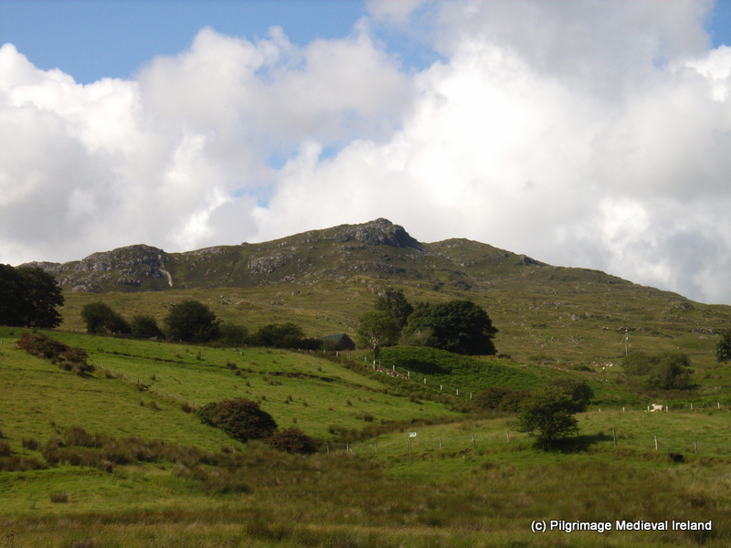
Much of what we know about Gobnait comes from folklore. Unlike many other Irish saints, Gobnait’s  life story was not written down during the medieval period. Tradition  and  links with  St Abban (also associated with Ballyvourney) suggests  she lived during the 6th century.  Today the main centres of devotion to Gobnait are  on  Inis Oírr/Inisheer ( one of  the Aran Islands), Dún Chaoin in West Kerry, Kilshanning, Co. Cork  and Baile Bhúirne/Ballyvourney near the Cork/Kerry border, where the local people venerate the saint on her feast day,  the 11th of February. Evidence of the saint’s cult  is also found in the dedications of churches and holy wells in the counties of Cork, Kerry, Limerick and Waterford.

There are two  folk versions of the  saints life. One  tells us that Gobnait was born in  Co Clare and due to a family feud fled of to the island of Inisheer where she founded a church. One day an angel appeared to her  and told her to head inland and  to find the  place of her resurrection. She was told she  would know this spot as it would be marked by  the presence of 9 white deer. She travel south in search of  this place and her  many stops  are marked by  churches and  holy wells dedicated to her, such as the medieval church at Kilgobnet,  Co Waterford.

At various stages of her journey Gobnait met  with white deer of varying numbers but it was only when she reached Ballyvourney that  she found the nine deer grazing  and it was here she  ended of her journey. In a Kerry version of her life, Gobnait  was said to be the daughter of a pirate who came ashore at Fionntraigh (Ventry, Co. Kerry).  Once ashore an angel appeared to her and  told her to go forth and search for the site  of her resurrection  and to travel on until she saw nine white deer grazing, which she did in Ballyvourney.

I will post more in the coming months about  Gobnait’s journey around Ireland and the other sites associated with her.  This post  will focus on the  evidence of  pilgrimage at Ballyvourney.

Metal working and bees

Gobnait was likely the patron saint of iron workers. The hypocoristic (pet name) form of her name Gobba come from Gabha which means smith.  Excavations  St Gobnait’s House/Kitchen at her shrine in Ballyvourney  in  the 1950’s,  prior to the erection of the modern statue of St Gobnait, revealed evidence  of iron working (smithing and smelting).

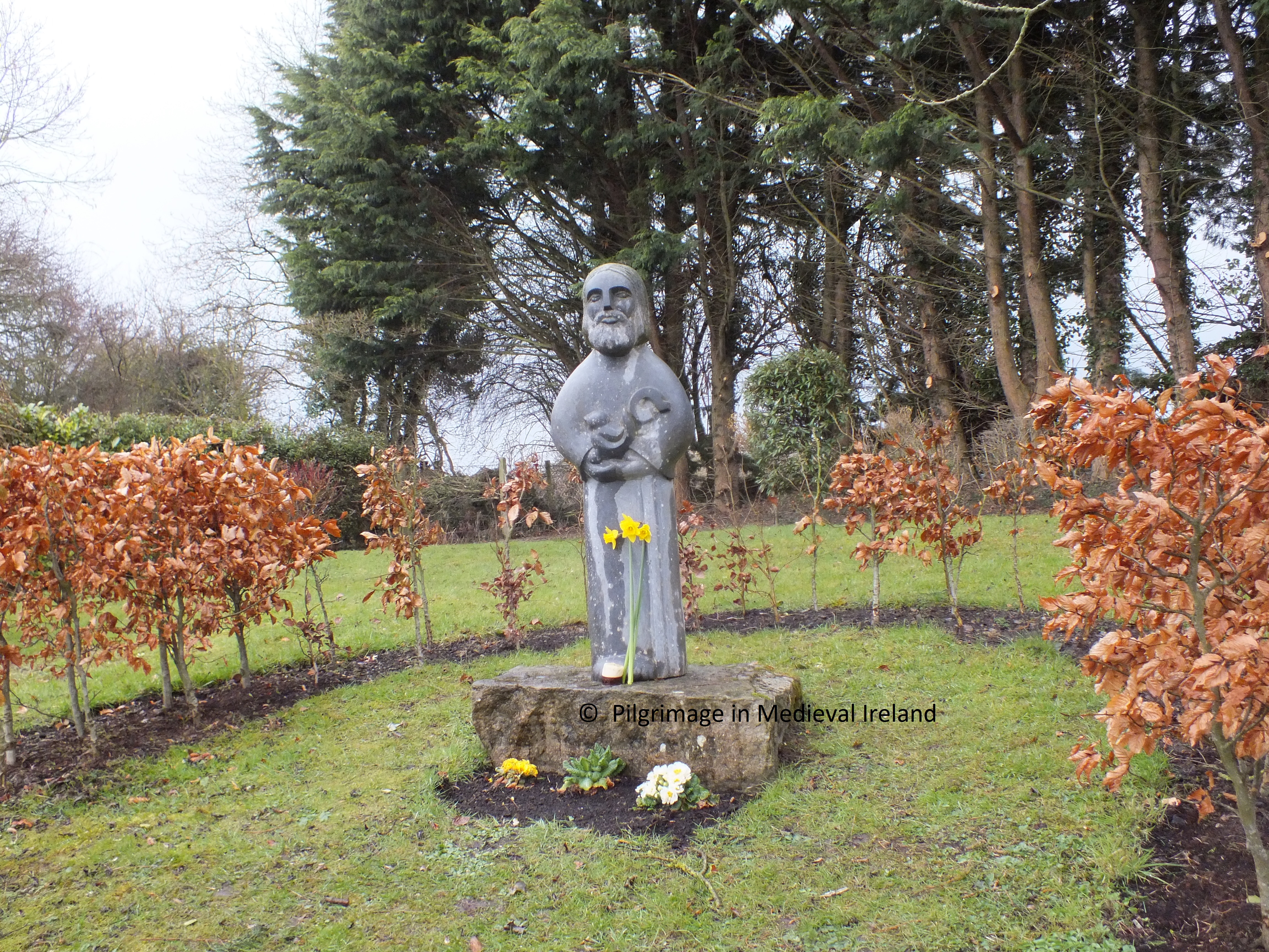
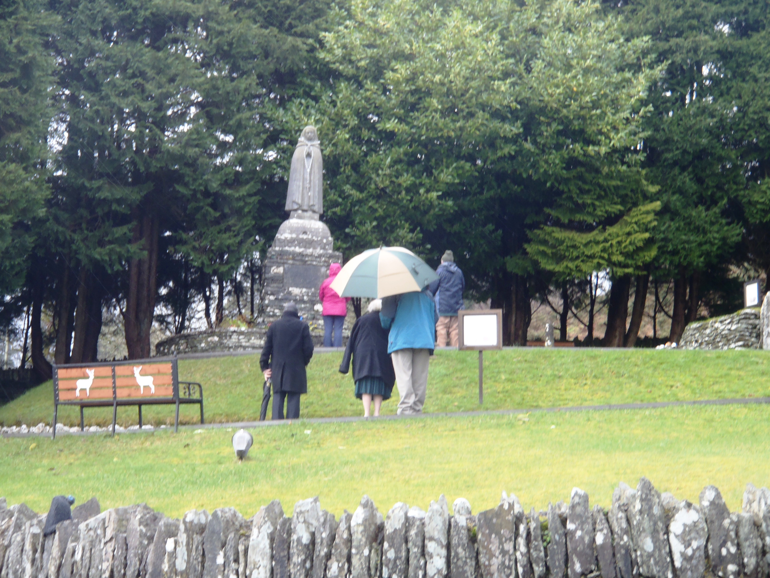
Gobnait was also the patron saint of bee keepers and kept her own bees.  There are a number of  legend  in which she unleashes her bees to attack enemies. In one  story soldiers came to Ballyvourney and stole livestock, as they left the village the saint  let loose her honey-bees upon them.  Another version of this tale has a band of robbers stealing her cattle and she sends her bees  after them and they promptly return the  cattle. It is this legend that inspired the Harry Clarke window. Many modern depictions of the saint  associate her with bees such as the  statue at her shrine in Ballyvourney by  Séamus Murphy.

20130211_152850

St Gobnait in the rain. Statue of St Gobnait created by Seamus Murphy in the 1950s.

Medieval Pilgrimage at Ballyvourney

Gobnait is not the only saint associated with Ballyvourney. St Abban had established a monastery here prior to her arrival. Abban gave her land and  helped she established a nunnery here. The traditional  site of Gobnait’s nunnery is the old graveyard and medieval parish church known as Teampall Ghobhatan ( the church of Gobnait).   I will come back to St Abban and his links to Ballyvourney in another post.

There is  little evidence  to suggest when pilgrims first began to come here. Unfortunately the archaeological and historical sources tell us nothing about pilgrimage prior to the 17th century.  Given the popularity of the saints cult  in the 17th century it is likely pilgrimage  likely  began many centuries prior to this date.

The silence of the historical and archaeological record concerning pilgrimage at Ballyvourney, should not be seen as  evidence that pilgrimage was not taking place in the early or later medieval period. Pilgrimage is seldom mentioned in the historical records and the act of pilgrimages  in most cases leaves little physical trace behind.

The earliest written reference to pilgrimage at Ballyvourney dates to the early 1600’s.   In 1601 Pope Clement VIII granted a special indulgence  of 10 years to those who, on Gobnait’s  feast day, visited the parish church, went to Confession and Communion and who prayed for peace among  ‘Christian princes’ , expulsion of heresy and the exaltation of the church’.  It is clear from this and other 17th century references,  such as the  poetry  of Dáibhidh Ó Bruidar, the writings of Don Philip Ó Súilleabháin and Seathrún Céitinn, that Gobnait’s  cult  was strong and popular during this period.

In 1603 Donal Cam Ó Súilleabháin during  his flight from Béara  stopped at Ballyvourney with his men to pray at Gobnait’s shrine, to offer gifts and to ask for her protection. The importance of Gobnait’s cult  is also attested by the  visited of  the Papal Nunico Rinuccini   in 1645 (Ó hÉaluighthe 1958, 47).

Devotion to Gobnait is again mentioned in the writings of Sir Richard Cox  in 1687,  who stated

Ballyvorney, a small village, considerable only for some holy relick (I think of Gobbonett) which does many cures and other miracles, and therefore there is great resort of pilgrims thither.

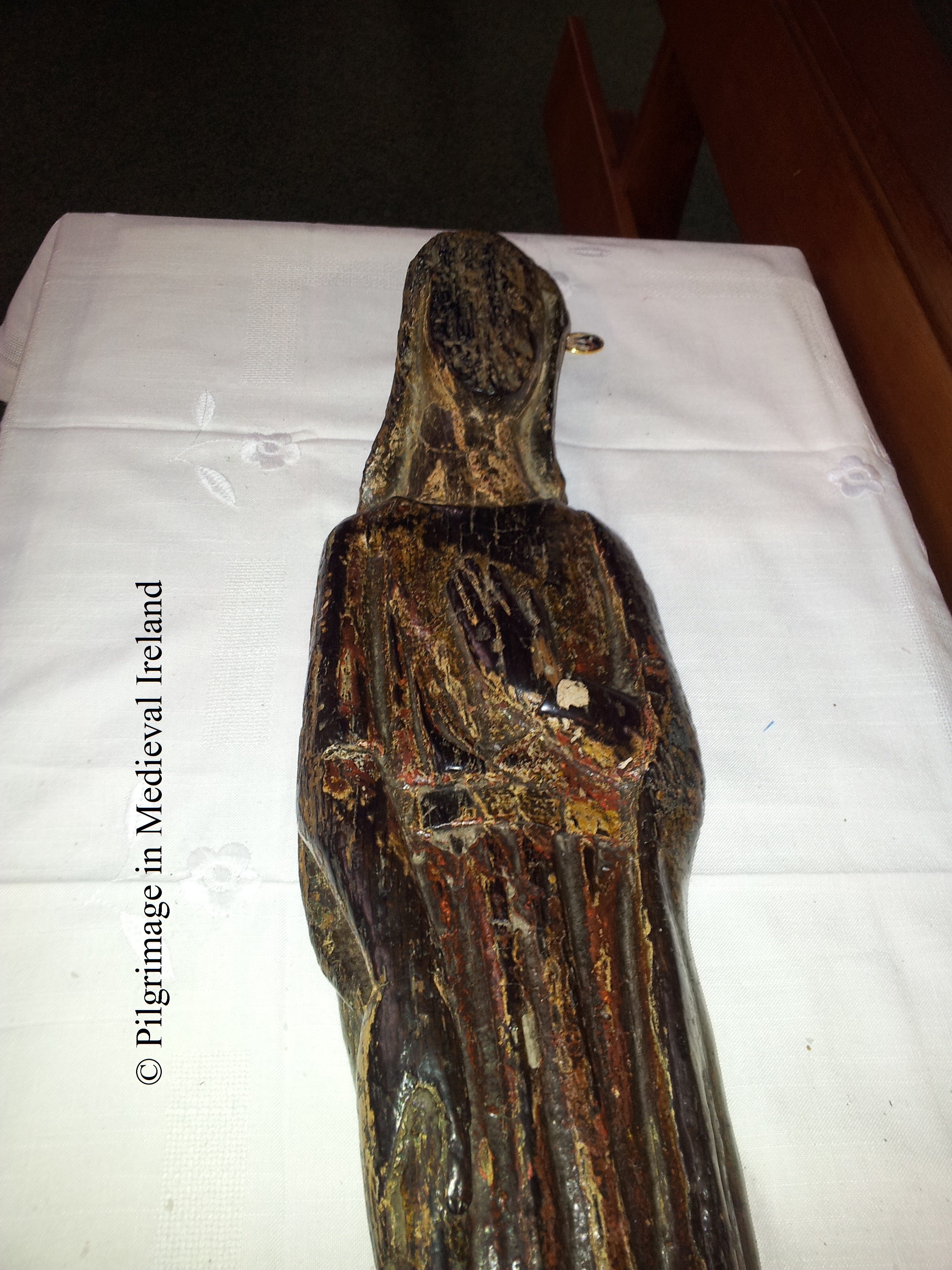
The relic  described by Cox is  a small  13th century medieval statue of St Gobnait, now in the care of the parish priest of Ballyvourney.

20130211_132934

Medieval statue of St Gobnait

Gobnait’s statue was again mentioned in 1731 when it is noted that

this Parish is remarkable for the superstition paid to Guibnet ‘s image  on Gubinet’s Day.

The literary sources suggest that  the hereditary keepers of the shrine and relics of Gobnait (the statue) were the  O’ Hierlihys family. Many of the relics of Irish saints  survived the reformation as they were kept  by individual families and passed down from generation to generation. These families were descendants of the family of stewards, or airchinnaigh, who controlled monastic lands and were often remunerated with a specific plot of land and fees when the relic was used. During the 18th & 19th century many of these families  fell on hard times and sold the relics some have been lost but thankfully many are now in the National Museum of Ireland. The statue of Gobnait continued to be cared for by the O’Herlihy family until 1843 when the statue was given into the care of the parish priest and it remains  in the care  to  church of Ballyvourney to this day.

John Richardson, a protestant gentleman with a low opinion of pilgrimage, gives an account of the 18th century pilgrimage at Ballyvourney in his book The Great Folly of Pilgrimage.  His account suggests that  devotion was focused on the aforementioned statue of St Gobnait  and makes no mention to any of the stations visited by modern pilgrims.

An Image of Wood, about two Foot high, carves and painted like a Women, is  kept in the Parish of Ballyvourney, in the Diocese of Cloyne, and the County of Cork; it is called Gubinet. The pilgrims resort to it twice a year, viz on Valintine’s Eve and on Whitsun Thursday…. it is set up for adoration on the old ruinous walls of the church. They go around the image trice on their knees saying a certain number of Paters, Aves and Credos. Then following prayer in Irish ‘A Gubinet, tabhair slan aon Mbliathan shin, agus sábháil shin o gach geine agus sórd Egruas, go speicialta on Bholgach’ and they conclude with kissing the idol and making an offer to it every one according to his ability, which generally amounts in the whole to 5 or 6 pounds.  The image is kept by one of the family of the O’ Herlihy’s and when anyone is sick of the small-pox, they send for it and scarifice a sheep to it, and wrap the skin about the sick person, and the family eat the sheep. But the Idol hath now much lost its Reputation, because two of the O Herlihys died lately of the Small pox. The Lord Bishop of Cloyne was pleased to favour me with the narrative of his rank idolatory, to suppress which he hath taken very proper and effectual methods (Richardson 1723, 70).

He goes on to say

Pilgrims kissed the statue, rubbed aching limbs to it, tied handkerchiefs about its neck, to be worn afterwards as a preventative against sickness (Richardson 1723, 71).

Richardson’s writings are very anti Catholic and written at a time when pilgrim was viewed as superstitious and backward by the established church, despite his negative tone his writing provides one of  the most detailed of the early accounts of pilgrimage at Ballyvourney.   During the  18th and 19th century pilgrimage was not just under pressure from the established church, many Irish pilgrimages were suppressed by the Catholic clergy  but thankfully the efforts of the then Bishop of Cloyne  to eradicate the pilgrimage at  Ballyvourney were in vain.

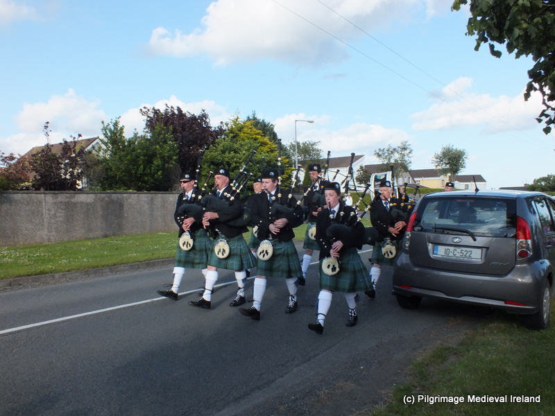
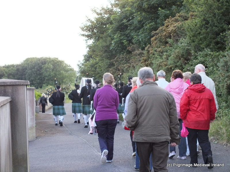
The modern pilgrimage at Ballyvourney on the saint’s feast day

I have been to Ballyvourney  on a number of occasions,  but this year was the first time I attended a pilgrimage. I arrived in the village around 10.30 am.   I was  told by some people i meet that was mass in honour of Gobnait, would be said at   11.30am  &  16.00pm  and that a rosary would be said at the shrine at 15.00 pm.  I was also informed  that people  visit the statue of Gobnait and  the shrine &  holy well to do their ’rounds’ (pilgrim prayer) throughout the day .

I headed first to the church to see the medieval statue of St Gobnait. The statue is a treasure possession of the parish of Ballyvourney and it is fascinating to think that it has survived here in this parish since the 13th or 14th century. Made of oak, it is approximately 27 inches/ 68 cm tall. The back is hollowed out from the shoulder to the feet. The face is now very worn and traces of  paint can be seen  on the front of the statue.  The folds of the saint’s dress and a belt are still visible. The feature of her face are now undiscernible but the details of her hands  (one hand is raised  to her chest and the other by her side) are clearly visible.

St Gobnait's Statue showing detail of hands

St Gobnait’s Statue, photo  showing detail of hands & robe

On the saint’s feast day the statue is displayed within the church. On the occasion of my visit it  was placed on a small table in the church in front of the altar.  A table with a large jar of colourful ribbons, key rings and booklets about Gobnait (all for sale) was located a few meters away  from the medieval statue in front  of a modern plaster statue of the saint.  People queued up and purchased fistful of ribbons and formed orderly lines to approach the medieval statue. The pilgrims armed with their ribbons (which they had brought with them or just  purchased) , were  no ready to  perform the ritual called St Gobnait’s measure. This is a practice  were pilgrims use the ribbons  to ‘measure’ the statue.

20130211_120807

Pilgrim’s taking ‘St Gobnait’s measure’ after mass in Ballyvourney church.

The ribbon(s) is held along the length of the statue and then wrapped around the neck, then the  waist and finally the feet of the statue. Some pilgrims make the sign of the cross when this is done, others pick up the statue and kiss it, while  others bless themselves with the statue.  The ribbon or in most cases ribbons are  then brought home and  used to ward off and to cure sickness.  Farmers often  placed  the ribbons in outhouses where there is livestock. As I sat in the church waiting for mass there was a constant line of people waiting to get to the statue. The scene reminded me of Richardson’s description  of pilgrims in 1723,  which tells of pilgrims tieing  handkerchief to the statue and then wearing them about the neck  as a preventative against illness.  It was fascinating to see that  modern pilgrims  are interact with  the statue in much the same manner as their ancestors almost 300 years before.  The church soon filled to capacity and a  mass was said in Irish.  There was a mix of people from within and outside the parish in attendance. Many  people had travelled some distance to get  here  and I heard one man say he came  that morning with his son from Killorglin in Co Kerry.

After  mass a new group of  people lined up  to visit the statue with their ribbons. I was told people would come throughout the day to visit the statue but the main burst of activity focused around mass times. When I passed by the church later at 16.15 the car park was again chock-a-block with cars.

Pilgrim stations at St Gobnait’s shrine.

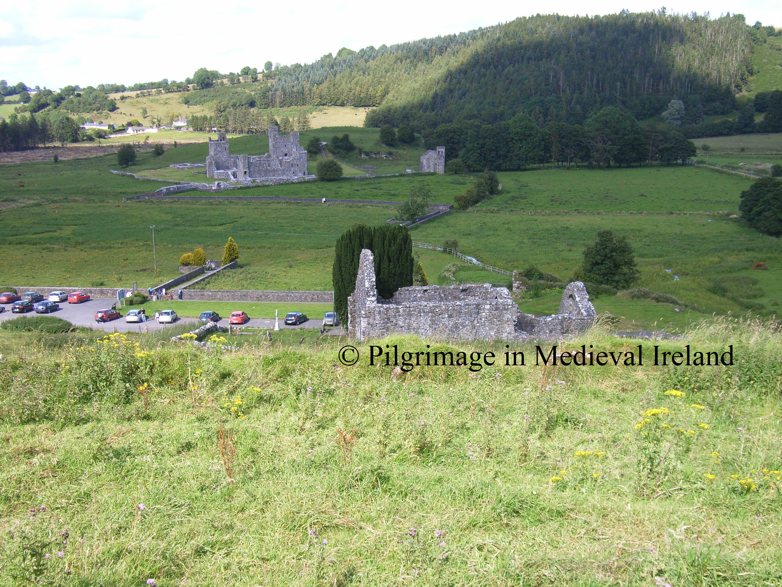
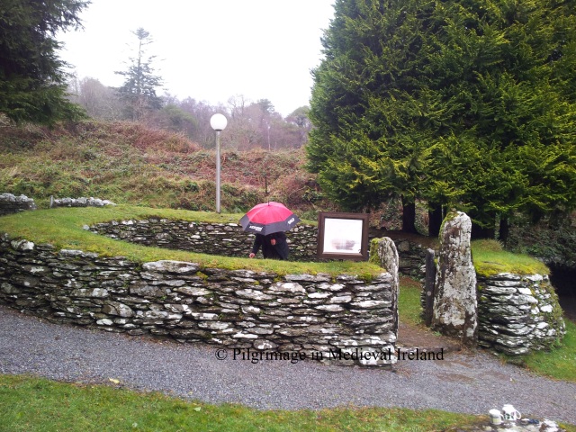
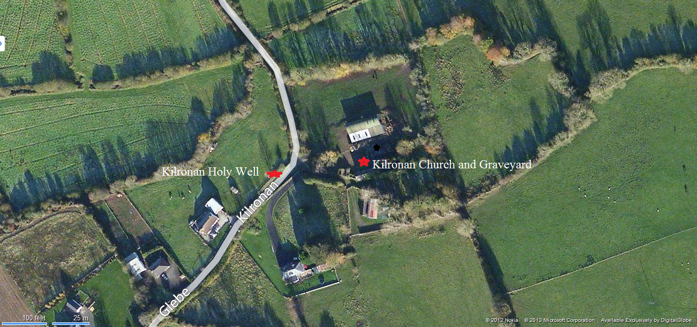
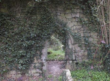
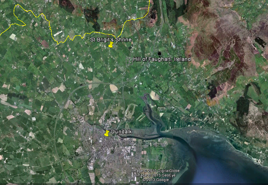
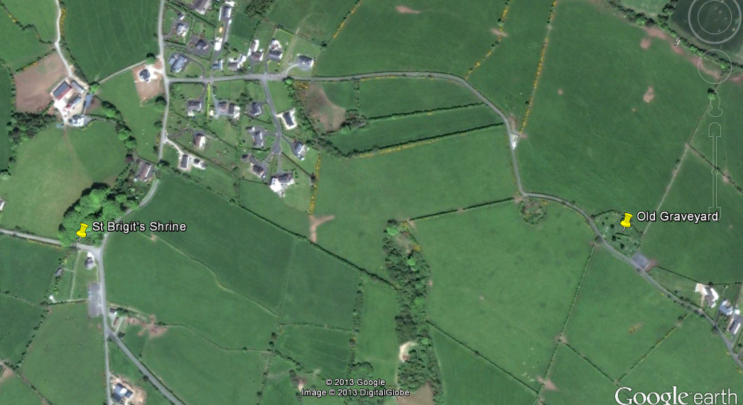
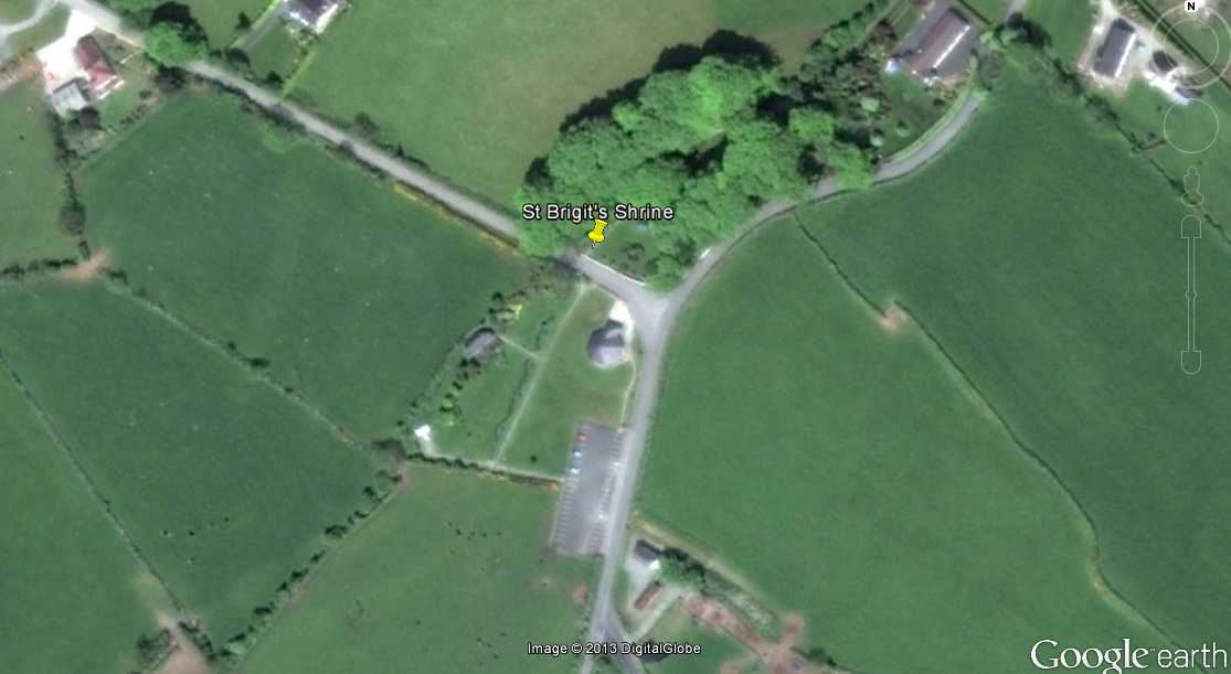
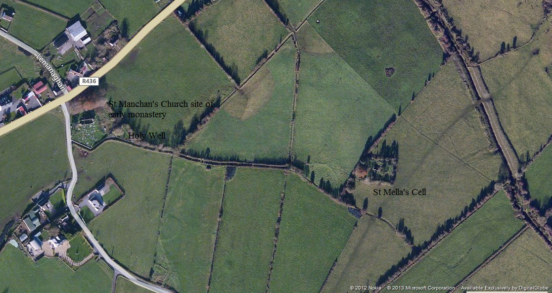
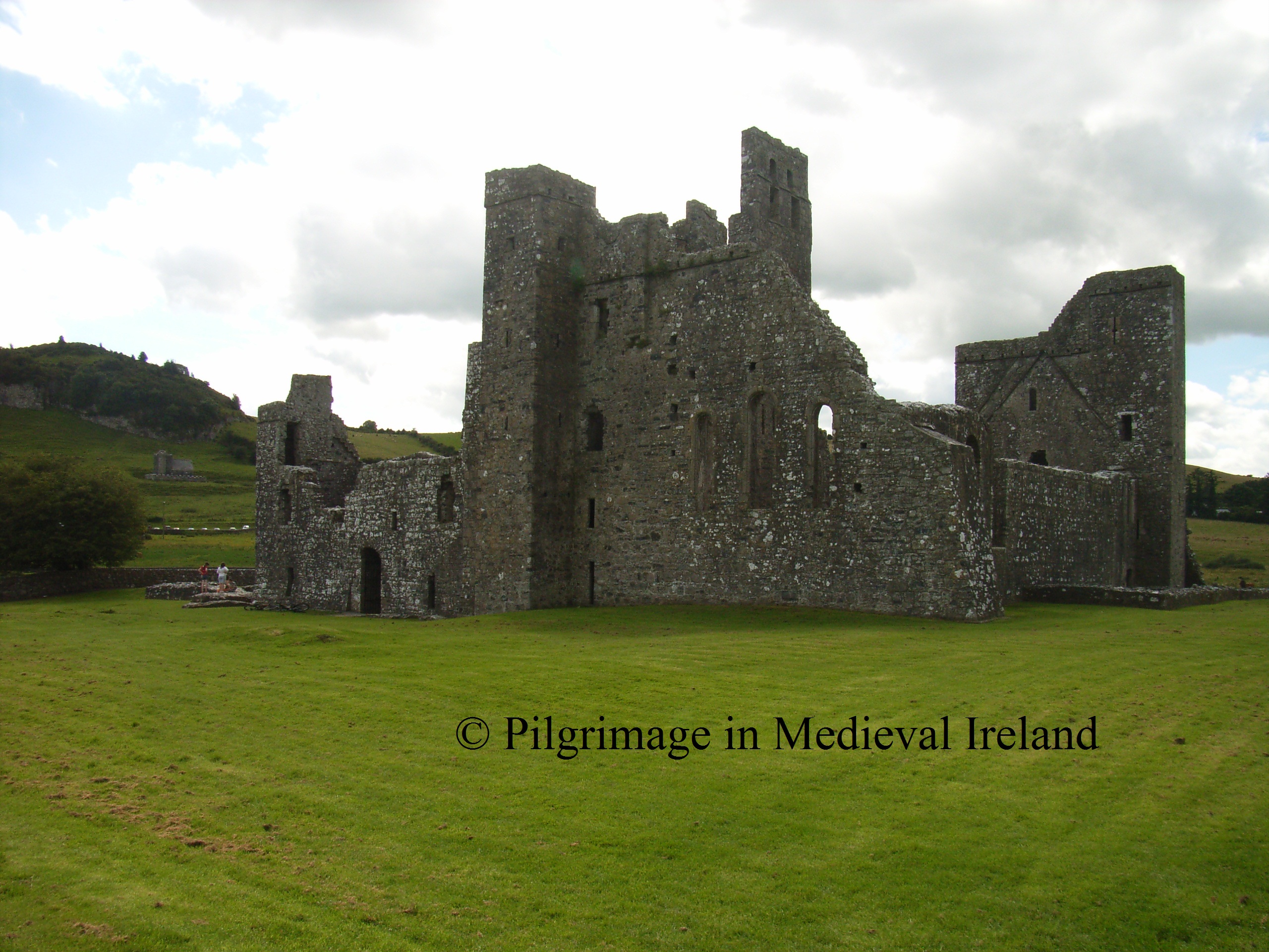
A short distance from the village is St Gobnait’s shrine,  the other focus of devotion for pilgrims to Ballyvourney. As I mentioned above St Gobnait’s shrine is the traditionally held to be the site of St Gobnait’s nunnery and the burial-place of the saint. Throughout the year it  attracts pilgrims on a daily basis. The main peaks in pilgrimage are Whitsun, the feast of St Gobnait, on the 11th of February and an open air mass in July.

StGobnait'sair004

Aerial shot of St Gobnait’s shrine (taken from http://www.leevalleywalking.com/about.htm)

The landscape of the shrine is divided  in two  with  St Gobnait’s house, holy well and statue  separated from  the other stations by a  modern road.  During the course of my visit  I meet another  blogger  Richard Scriven  (Geography UCC)  who is currently doing PhD research  on the modern pilgrimage at Ballyvourney. For more details of Richard’s research check out his blog http://liminalentwinings.com/.

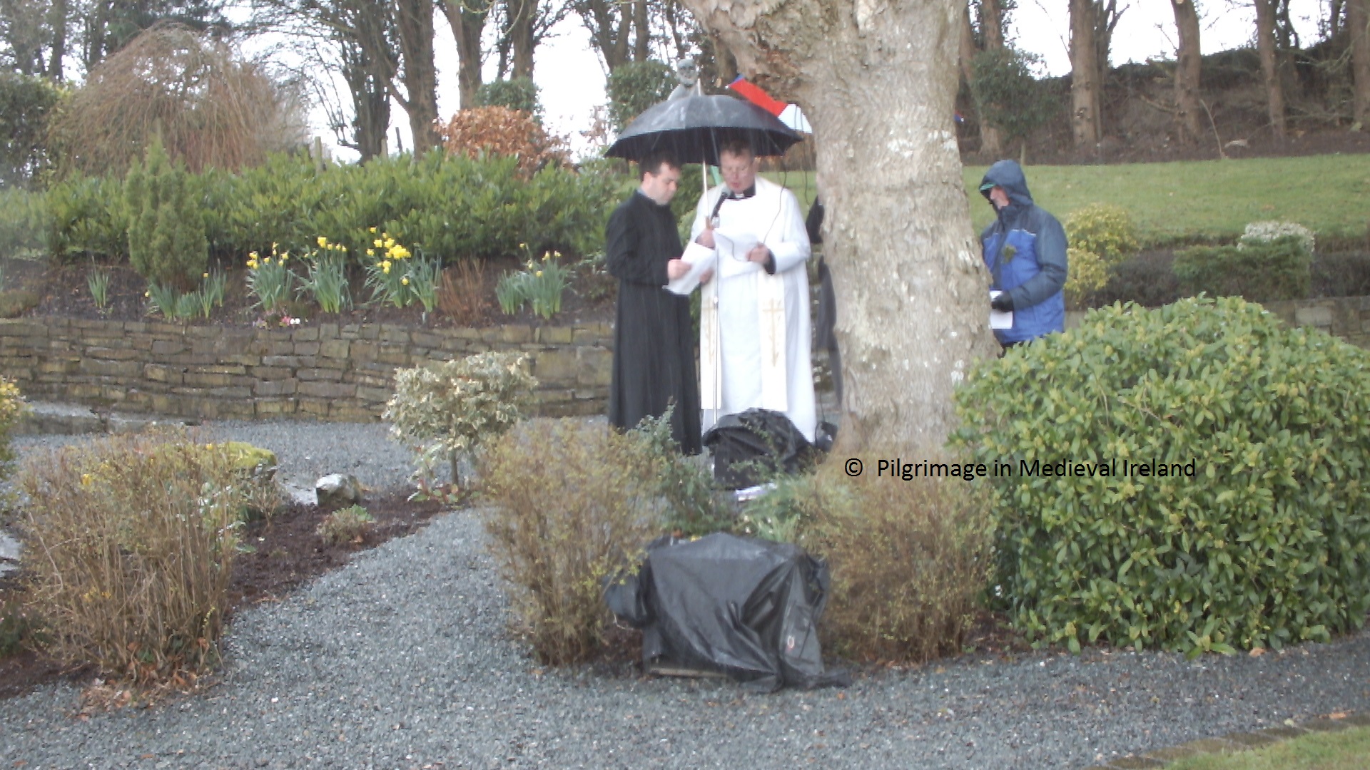
The day was  very cold with light to heavy showers but during the time I was here there was a constant  stream of pilgrims. Most  pilgrims  were  in  small groups of two or three and many were alone.  A small crowd gathered  at  15.00, for the rosary ,  in the area beside St Gobnait’s house.  Many of the people here who attended  the rosary  left afterwards perhaps to catch the 16.00 mass, while a small group remained to do the stations.

Pilgrim's at the Rosary  at Ballyvourney

Pilgrim’s  hiding from the rain during the recitation  of the rosary at Ballyvourney

Modern  information boards  are found  beside all the  pilgrim stations and detail the required prayers for each stations.

20130211_145224

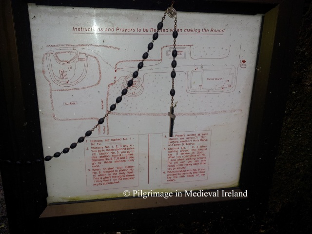
One of the modern notice boards located at the shrine.

The  following details of the rounds is taken from the book  Saint Gobnait of Ballyvourney by  Bernie Donoghue Murphy written in c. 2007.

Pilgrimage begins in front of the  statue of Gobnait.  The  pilgrim recites  7 Our Fathers, 7 Hail Mary’s and 7 Gloria,  then walks clockwise ‘ ar deiseal’  around the outer path (around the periphery of the site) reciting the Apostles Creed. The practice of  pilgrims walking in a clockwise circuit can be traced back to early medieval times and  continued in post medieval and modern times.

???????????????????????????????

Pilgrims beginning their round  before the modern statue of St Gobnait.

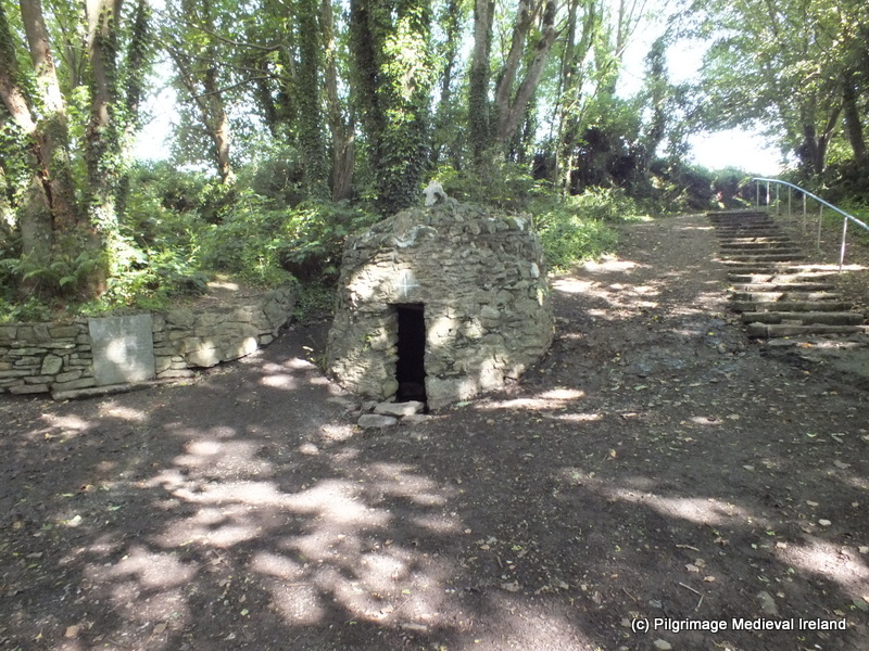
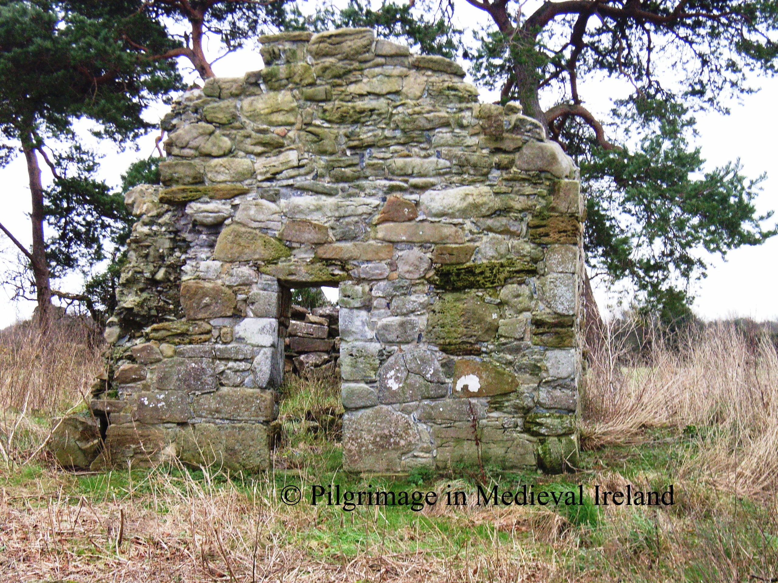
At St Gobnait’s House (station 2)  the pilgrim recites 7 Our Fathers, 7 Hail Mary’s and 7 Gloria.  The pilgrim  walks clockwise around the  station reciting the apostles creed. I also saw people go inside the hut and walk clockwise around the interior and finish by marking a modern pillar with a cross.

20130211_152925

Pilgrim within St Gobnait’s house marking the centre pillar with a cross.

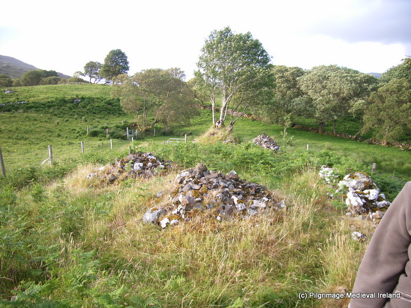
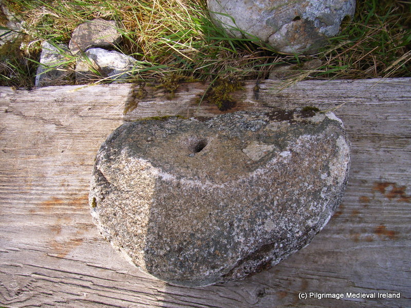
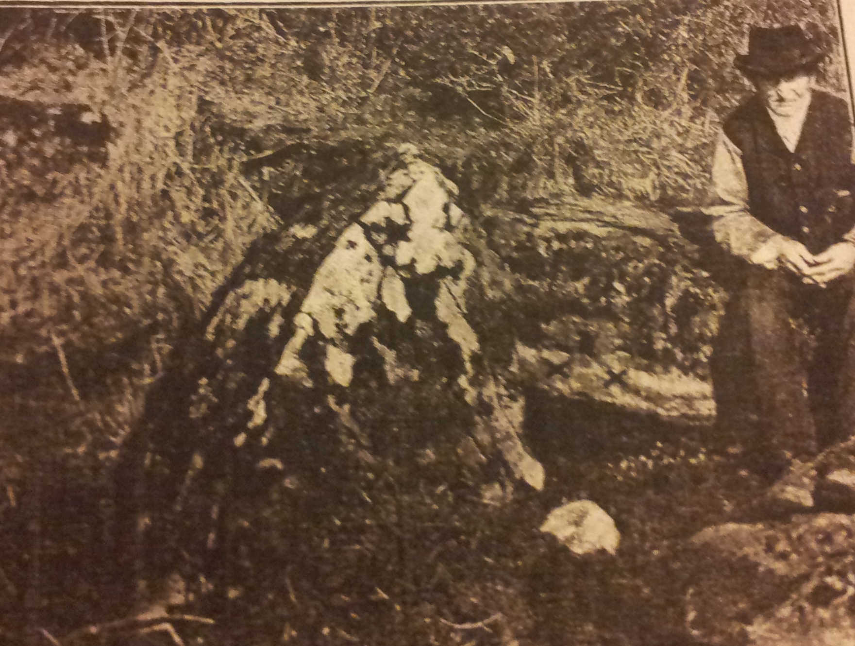
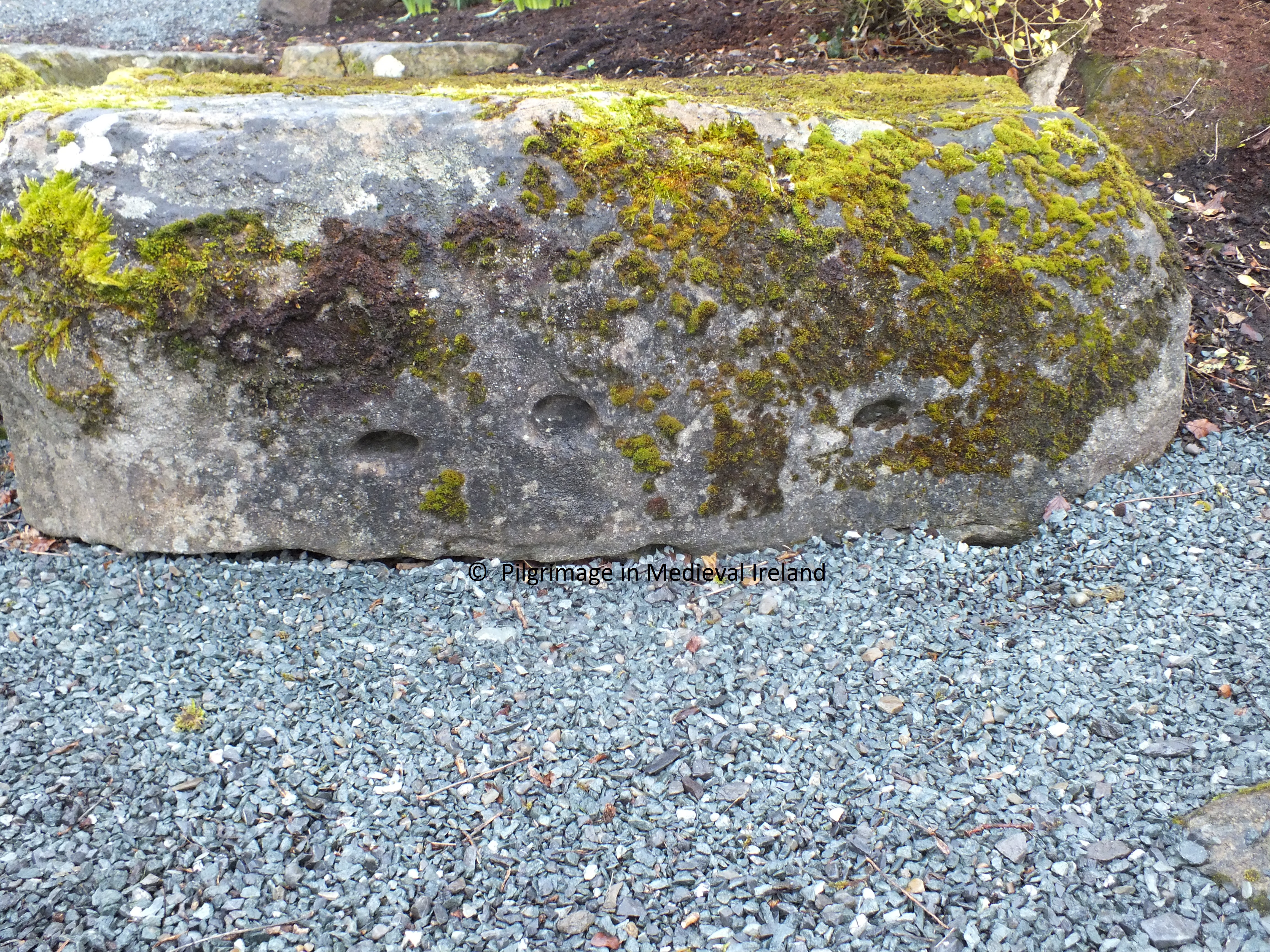
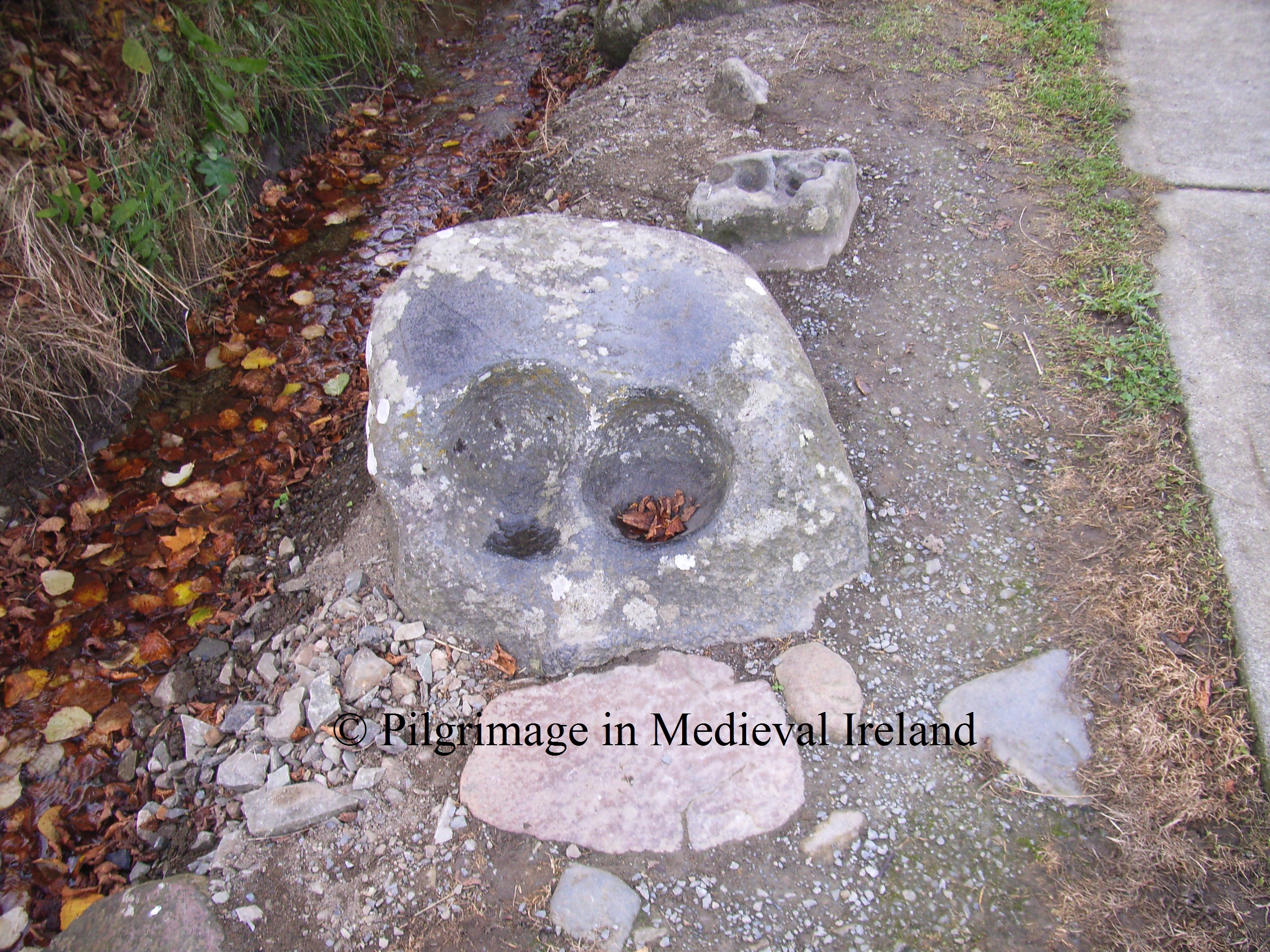
This station  was in ruins  1950s. It was restored   following an  excavation of the site by M. J. O’Kelly  and rebuilt  to its current state. The results of this excavation suggests the structure was used for craft working in the early medieval period. Large amounts of slag (the waste product of  iron smelting),  a crucible  and other artifacts connected with iron working were recovered. Two  bullaun stones (stones with man-made depressions), artifacts which many scholars believe were used to grind metal ores are found close by at the site of Gobnait’s grave.

20130215_135753

Pilgrim praying at St Gobnait’s house (Ó hÉaluighthe 1958, Pl. 2)

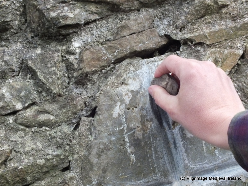
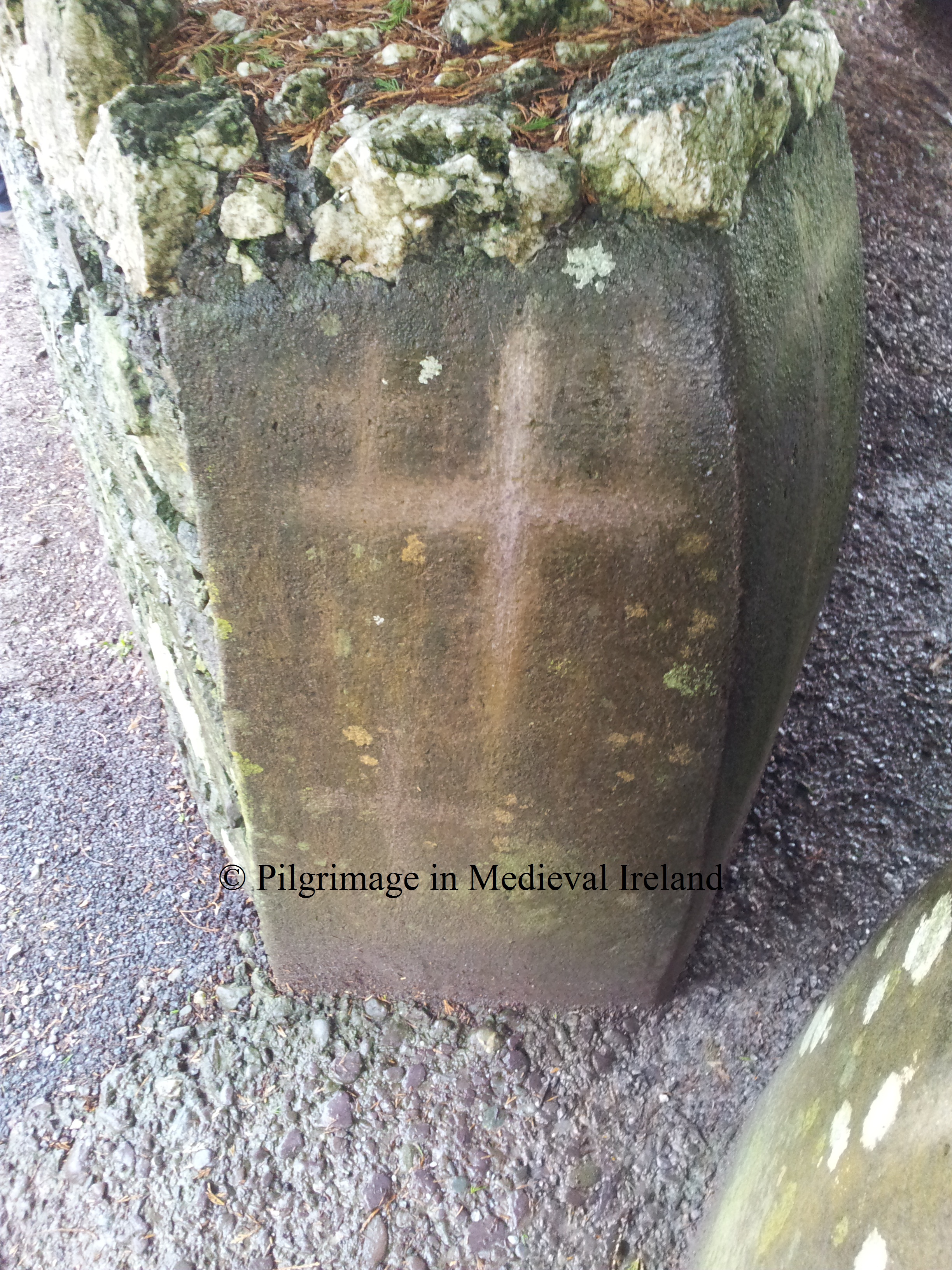
Modern pilgrims  have marked  stones around the  shrine  with crosses as part of their prayers.  The two entrance stones to St Gobnait’s house are marked by crosses,  as are the  modern  cylinder shaped pillars within the  hut and various stone in St Gobnaits church. This practice is seen at other pilgrim sites such as St Declan’s well at Ardmore. Such activity dates to  post medieval and modern times. Small pebbles are left on top of these stone for  pilgrims to  incise the sign of the cross.

20130211_153121

Crosses marked on the top of the modern pillar.

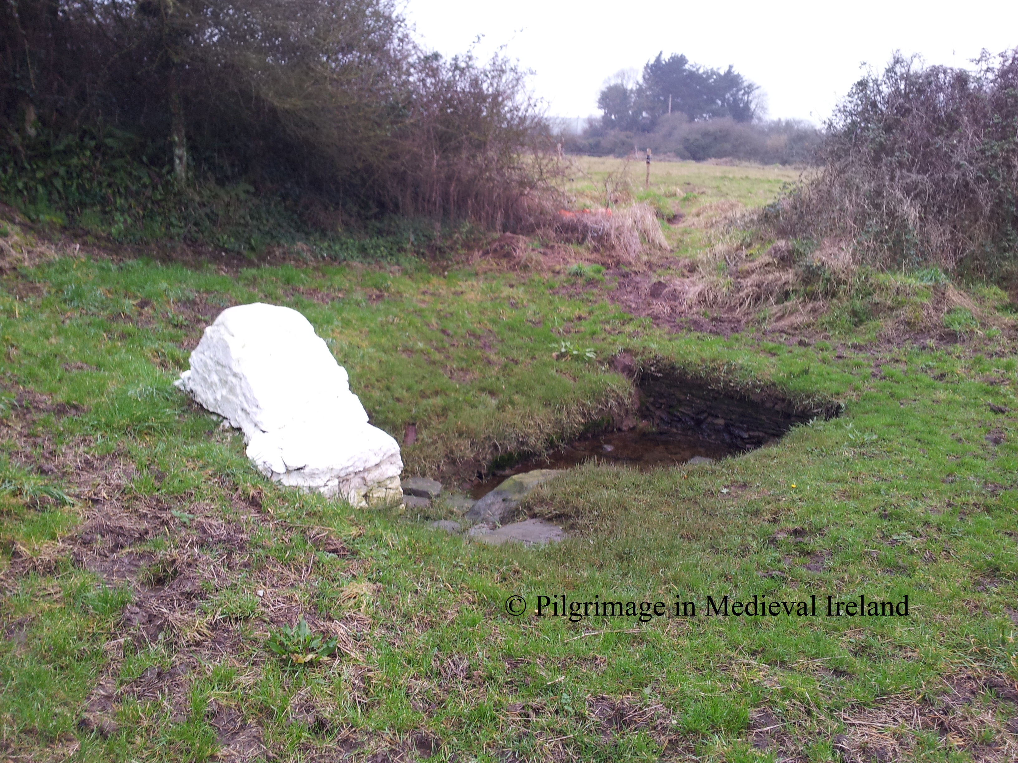
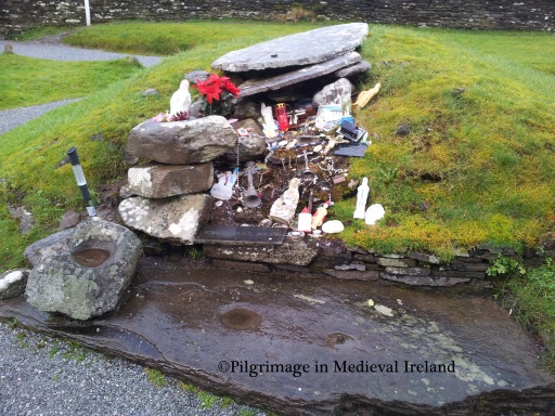
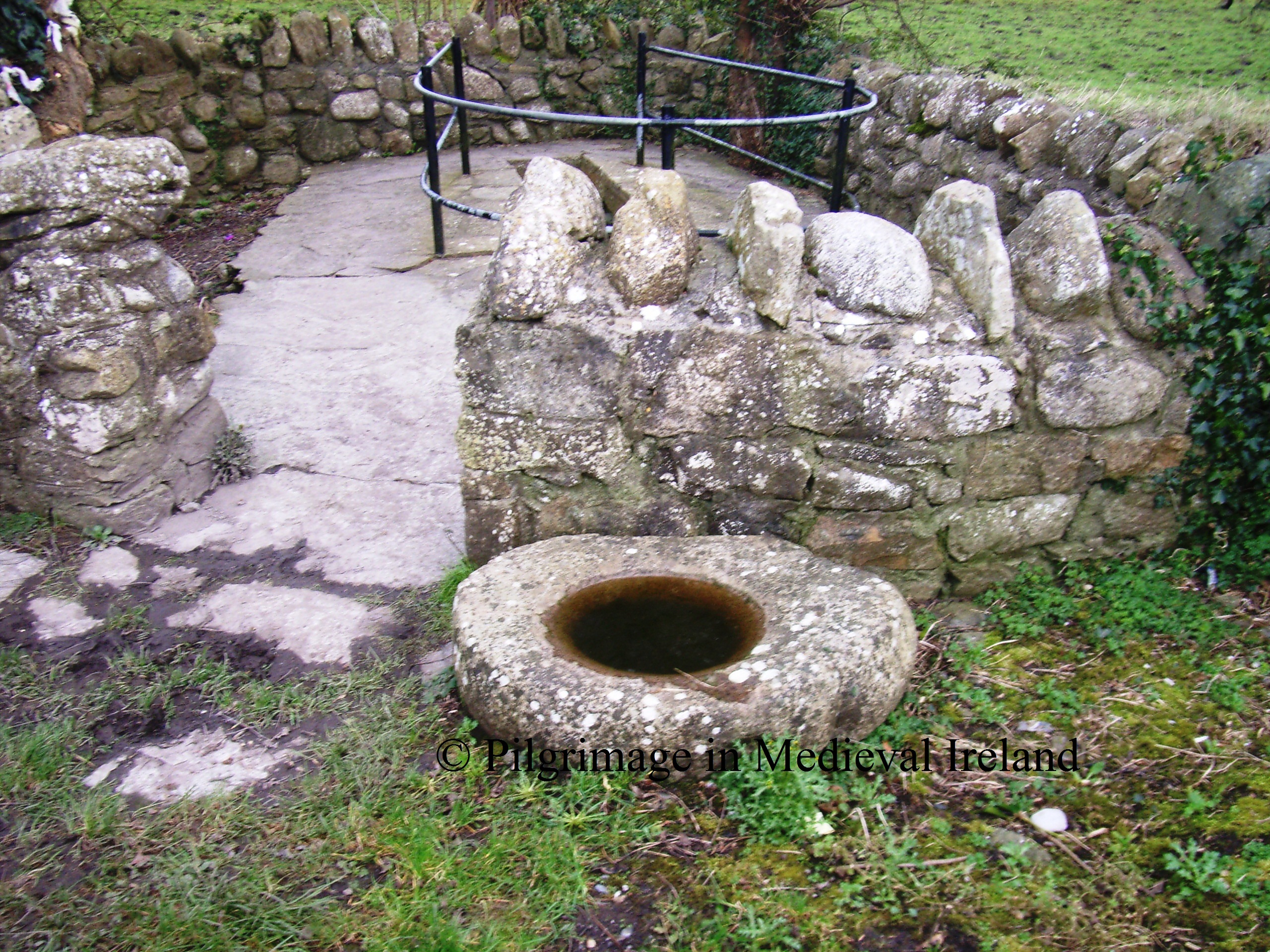
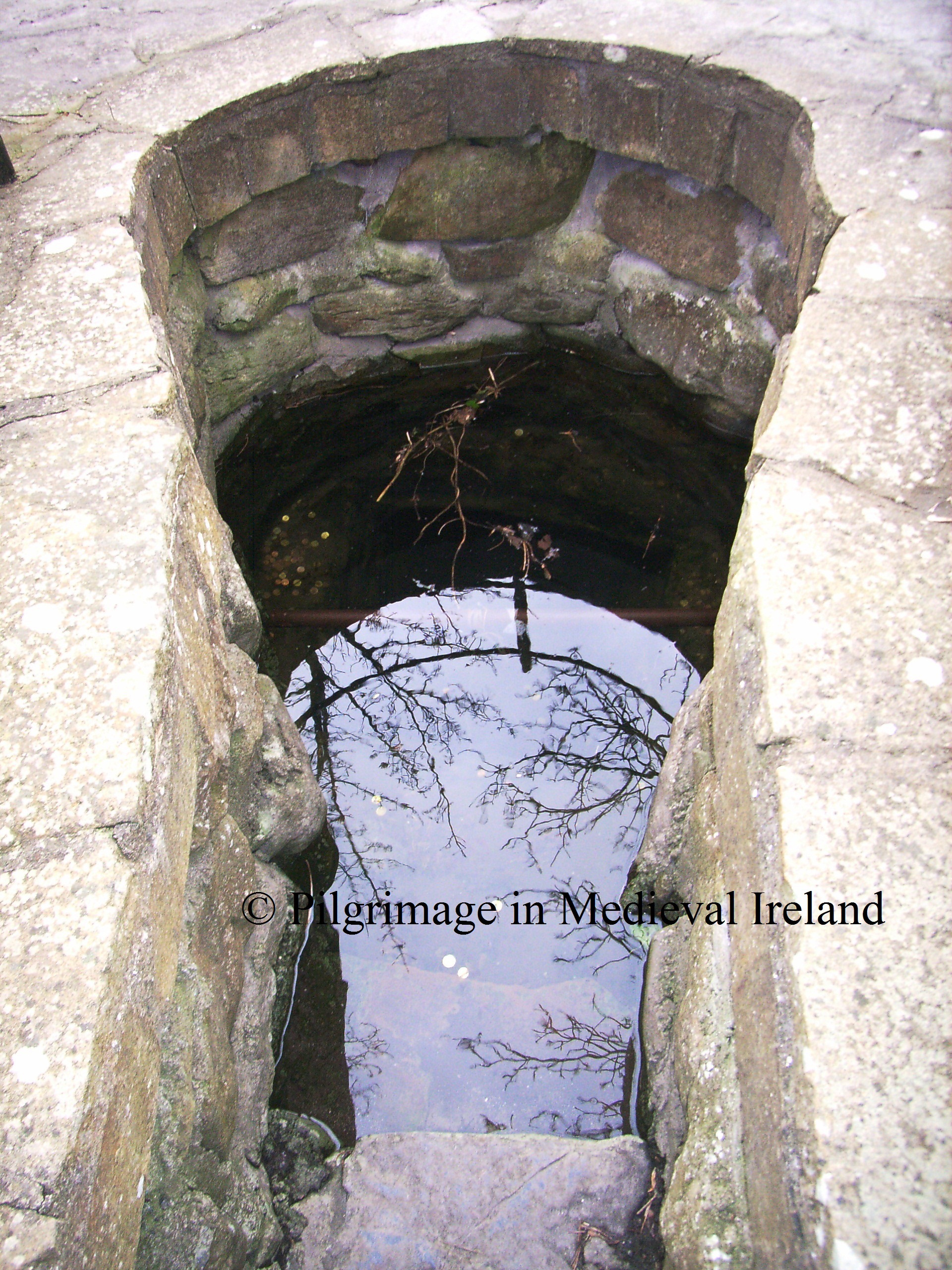
Having finished the prayers at station 2 ,  the pilgrim goes to the near by holy well , one of two wells associated with Gobnait at the shrine. The pilgrim then kneels down and  drinks some water from the holy well.

20130211_135140

Holy well beside St Gobnait’s house.

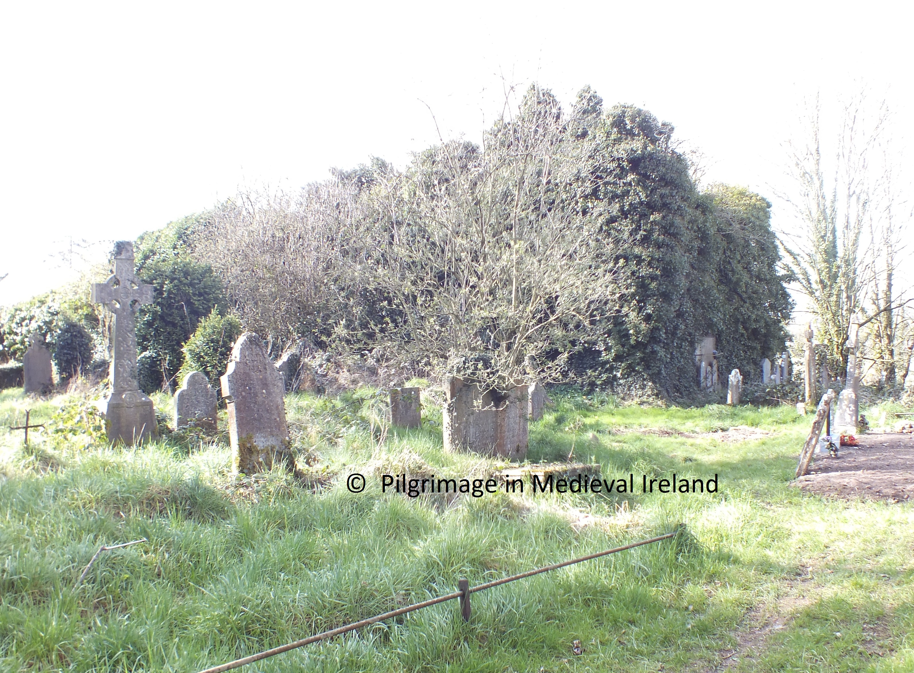
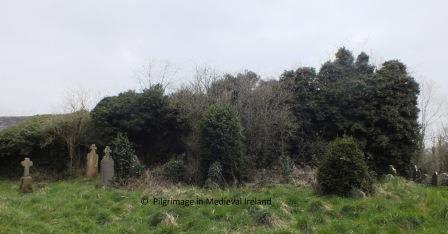
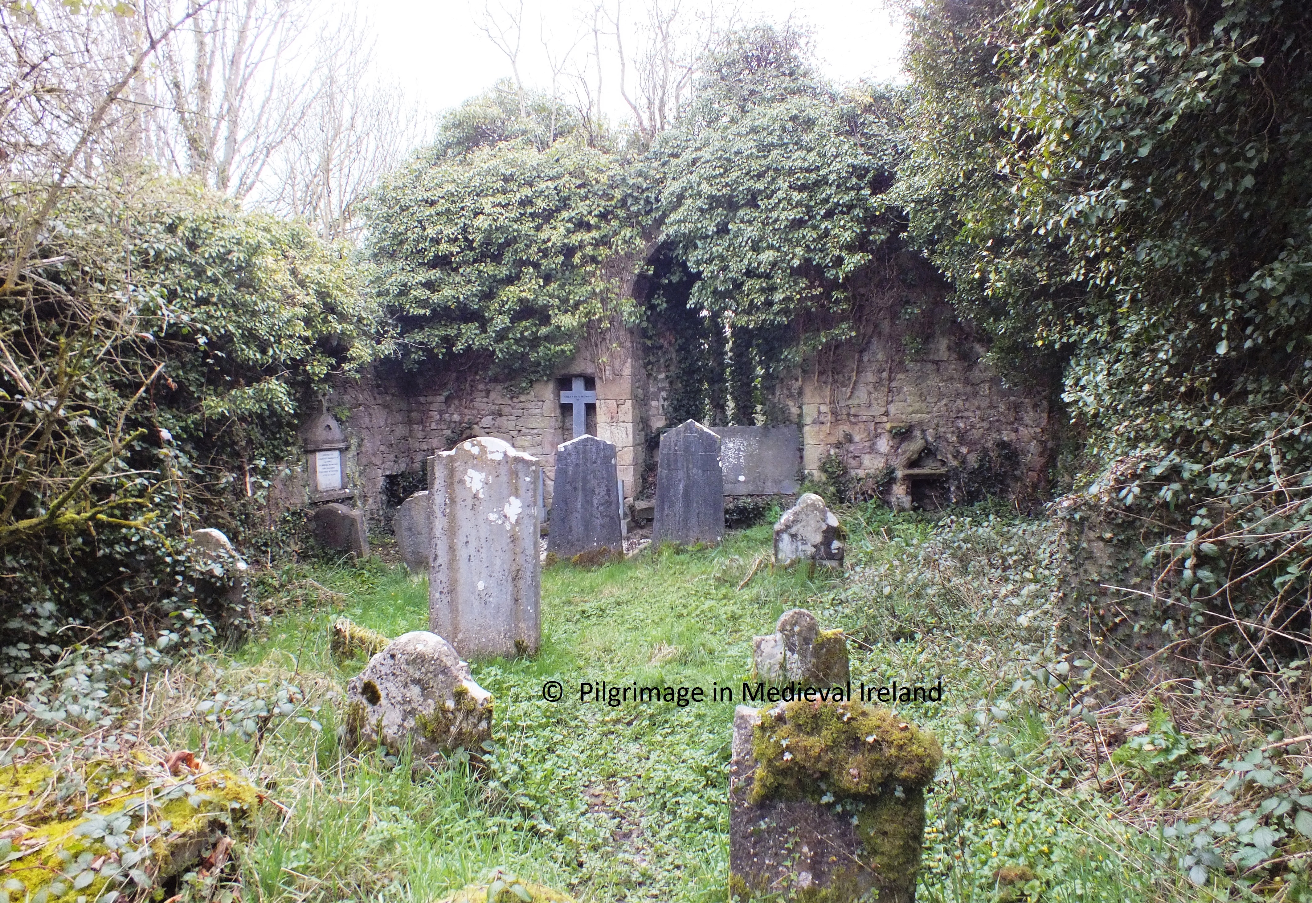
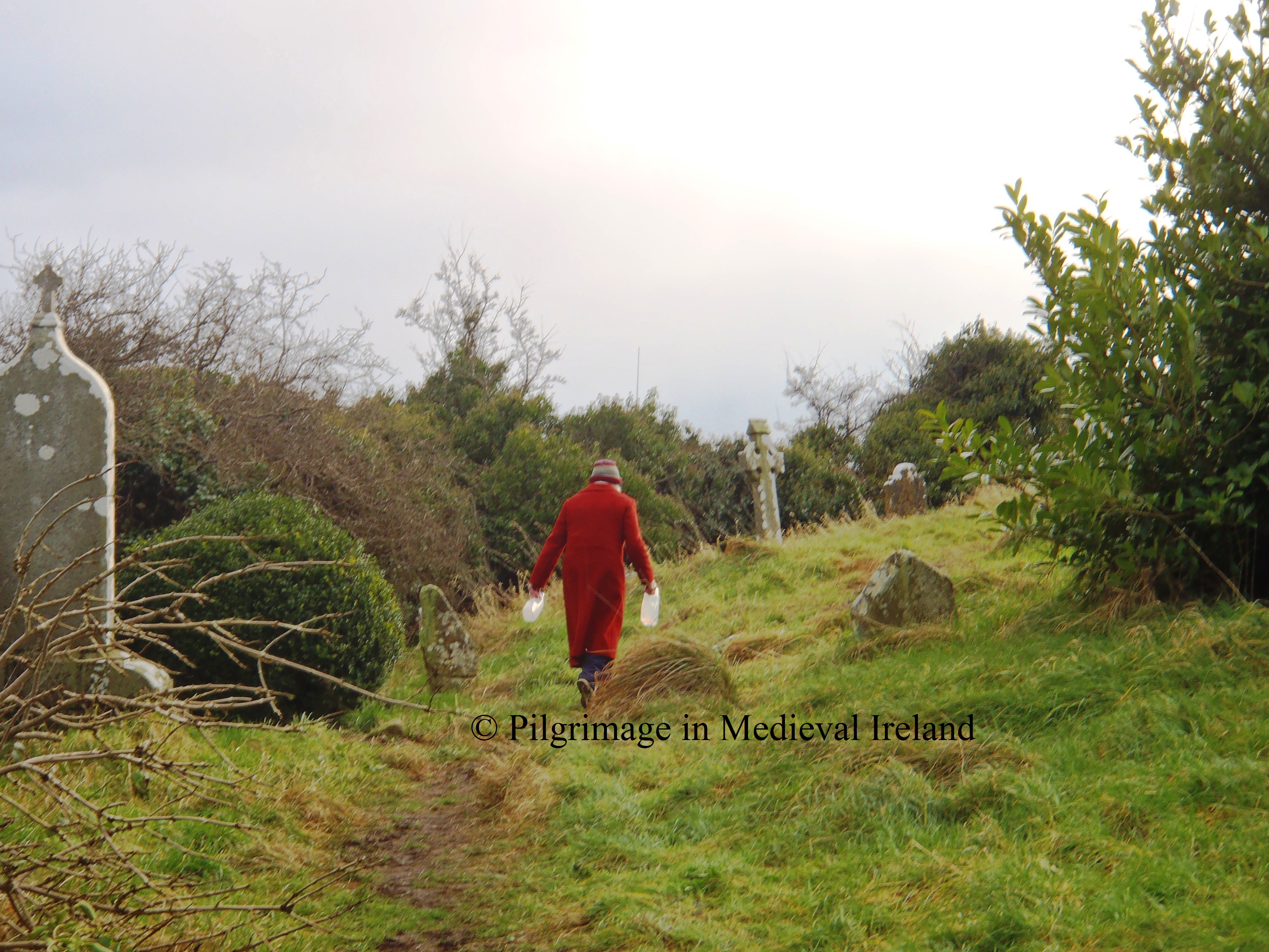
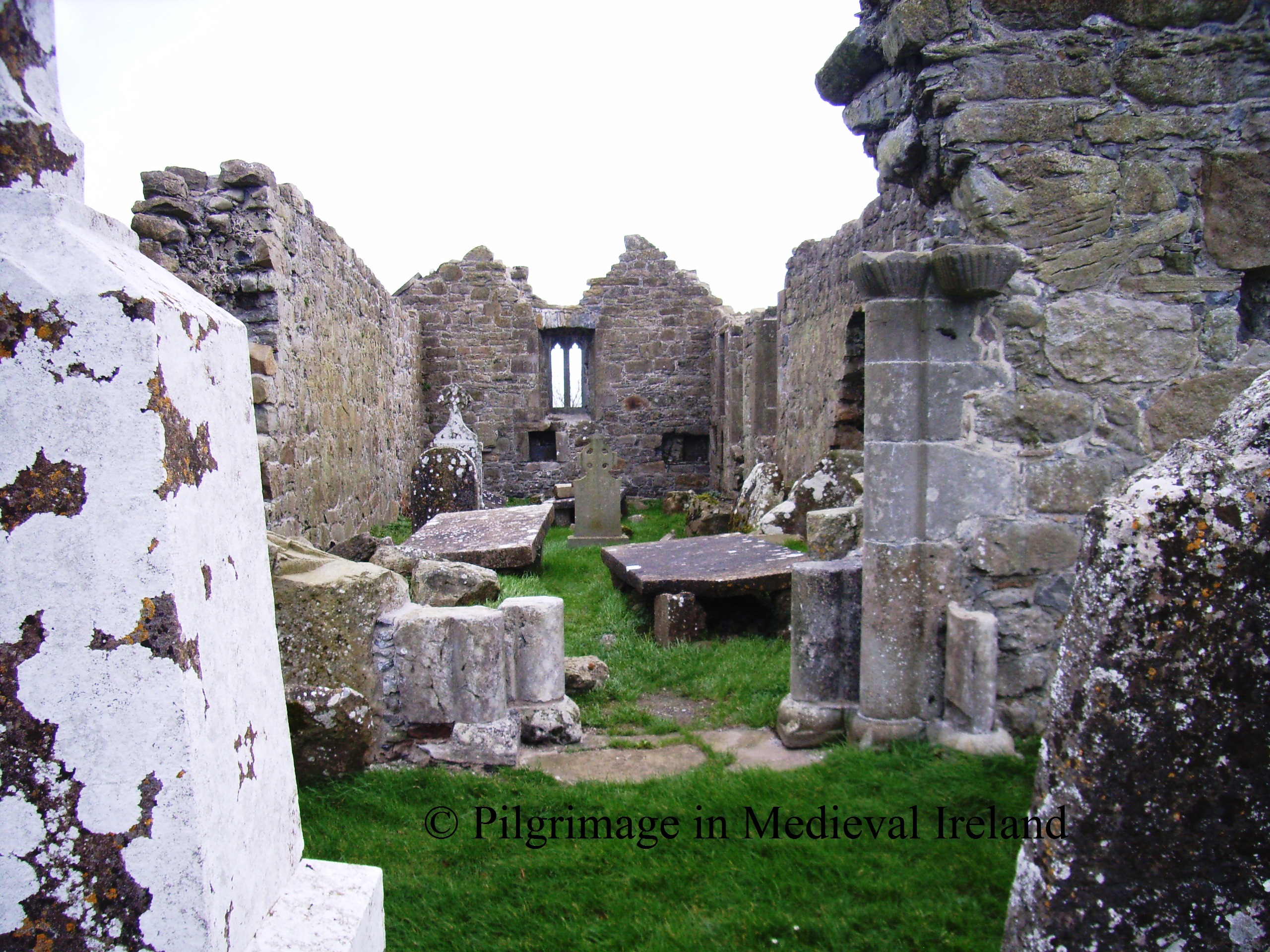
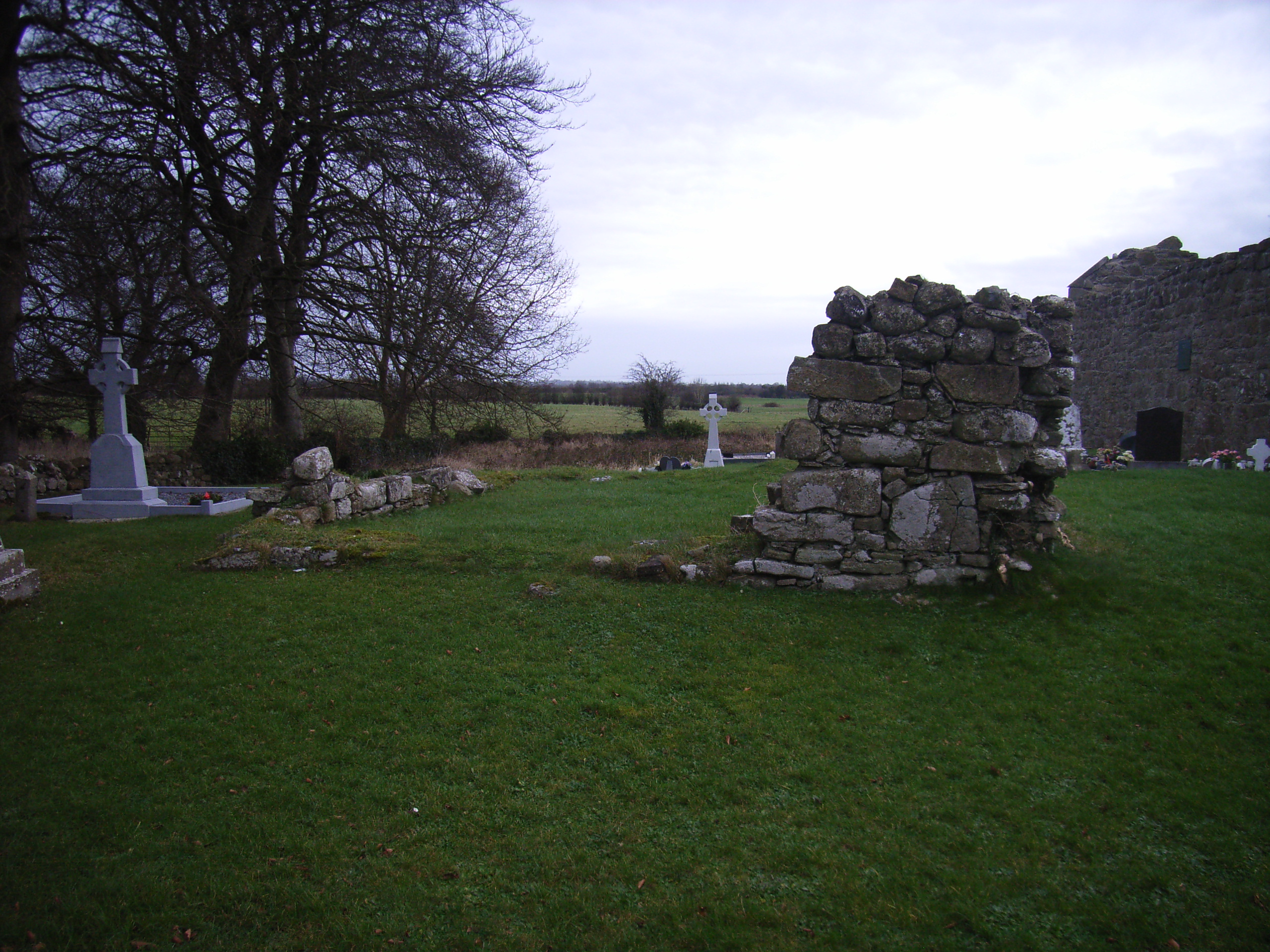
The remaining stations are  found  within the old graveyard. The pilgrim then crosses the road and enters the old graveyard.

20130211_153157

Crosses etched on the modern styles

Station 3 & 4 are located beside each other, close to the main entrance to the graveyard.  At station 3  the pilgrim  recites 7 Our Fathers, 7 Hail Mary’s and 7 Gloria. The pilgrim  walks  twice clockwise around the this station ( station 4 is at the centre of this path) reciting the apostles creed.

20130211_142618

Pilgrims praying at Station 3 & 4.

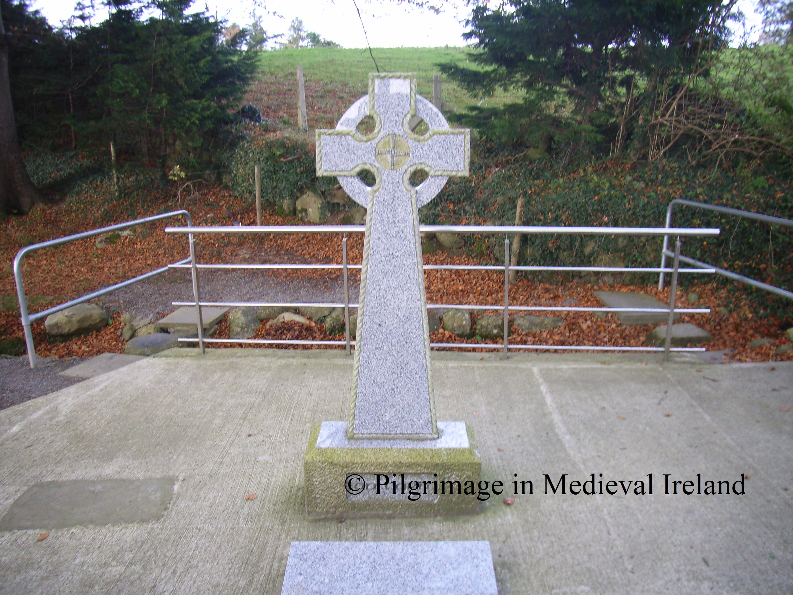
Station 4  is a sod-covered mound of loosely packed stones (4m N-S; 5.6m E-W; H 1.3m) known as  St Gobnait’s grave. The pilgrim recites 7 Our Fathers, 7 Hail Mary’s and 7 Gloria.  The pilgrim then walks  twice clockwise around  this station reciting the apostles creed.

20130211_154604

Station 4 St Gobnait’s grave.

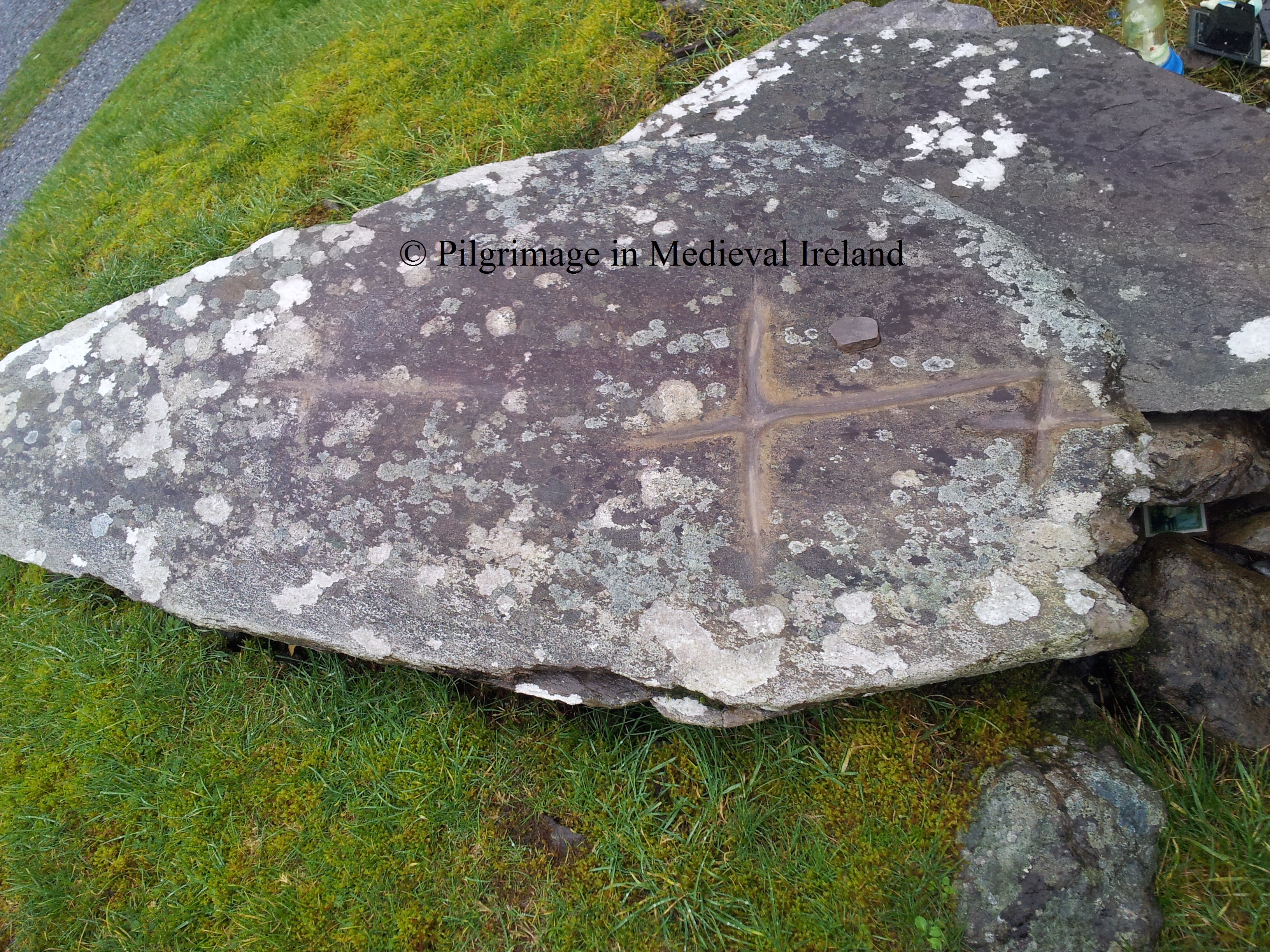
On top of the mound is a large flat slab which pilgrims  have  incised with a  cross. A small pebble is left beside the cross. This station is very colourful and eye catching. Pilgrims have  left  behind votive offerings such as  holy statues, medals,  rosary beads & crucifixes.

20130211_153327

Cross incised by pilgrims on slab on top of St Gobnait’s grave.

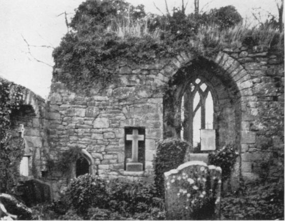
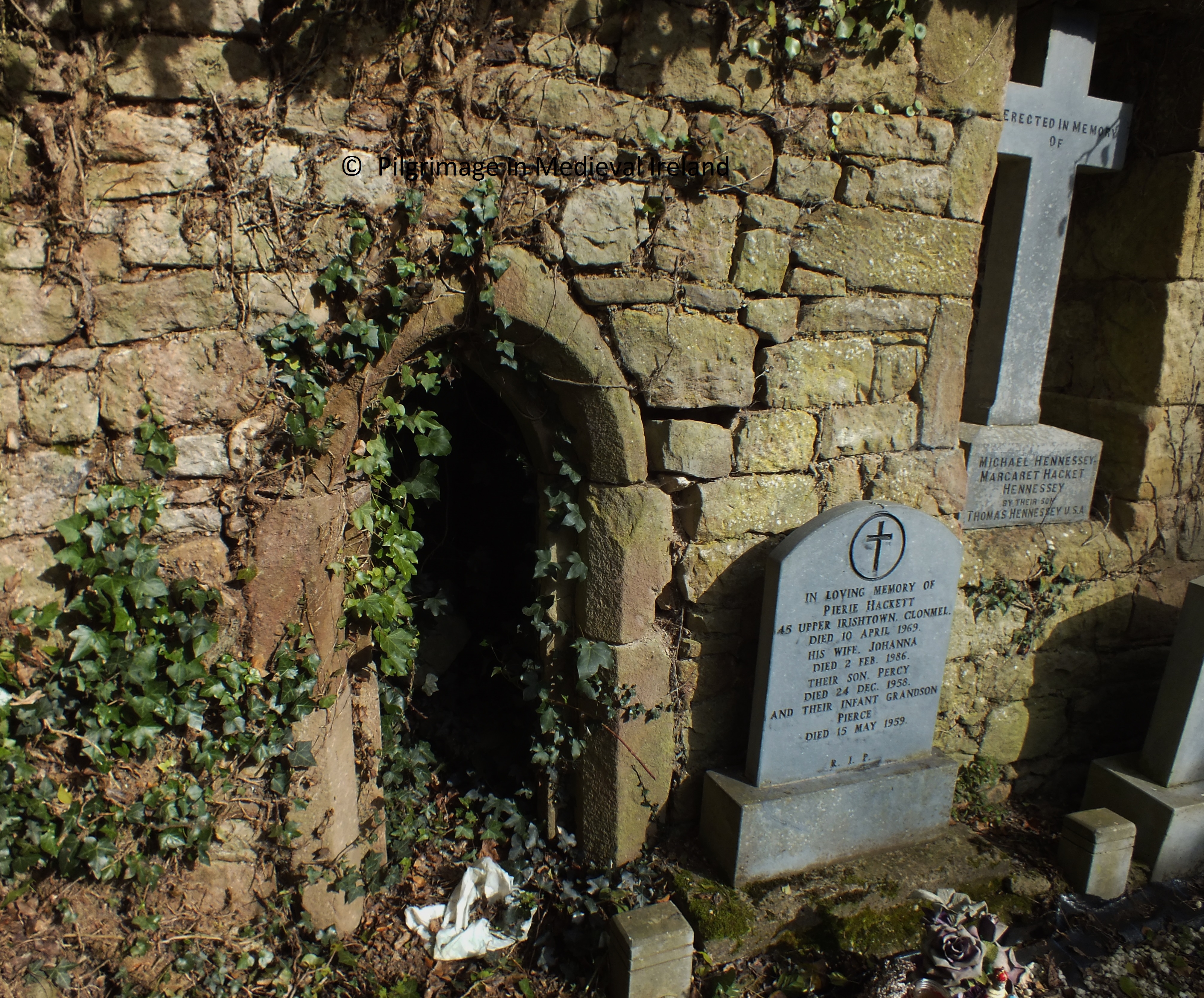
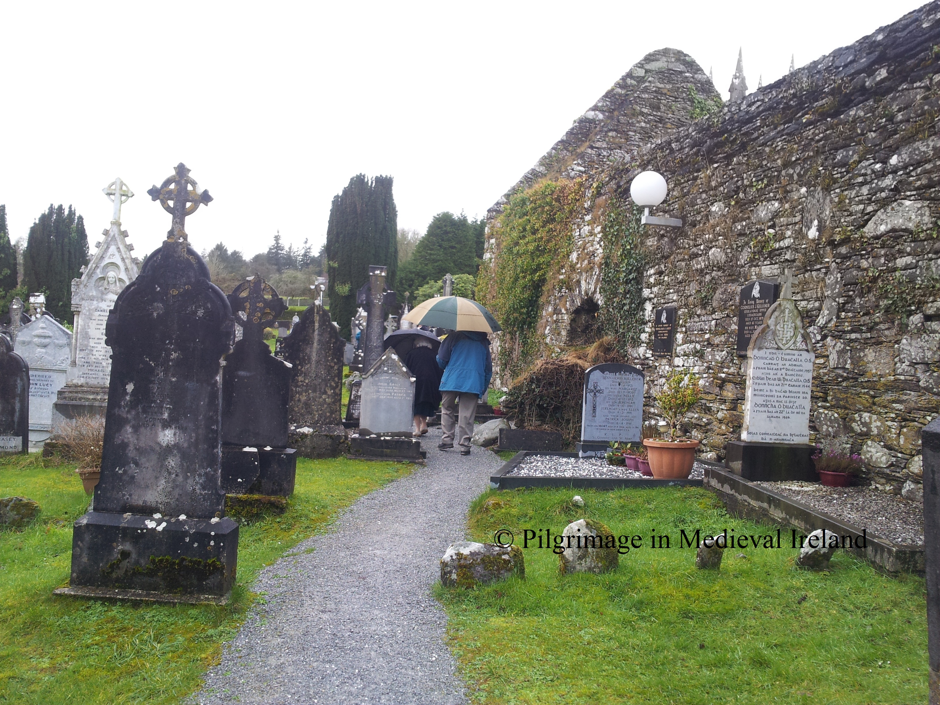
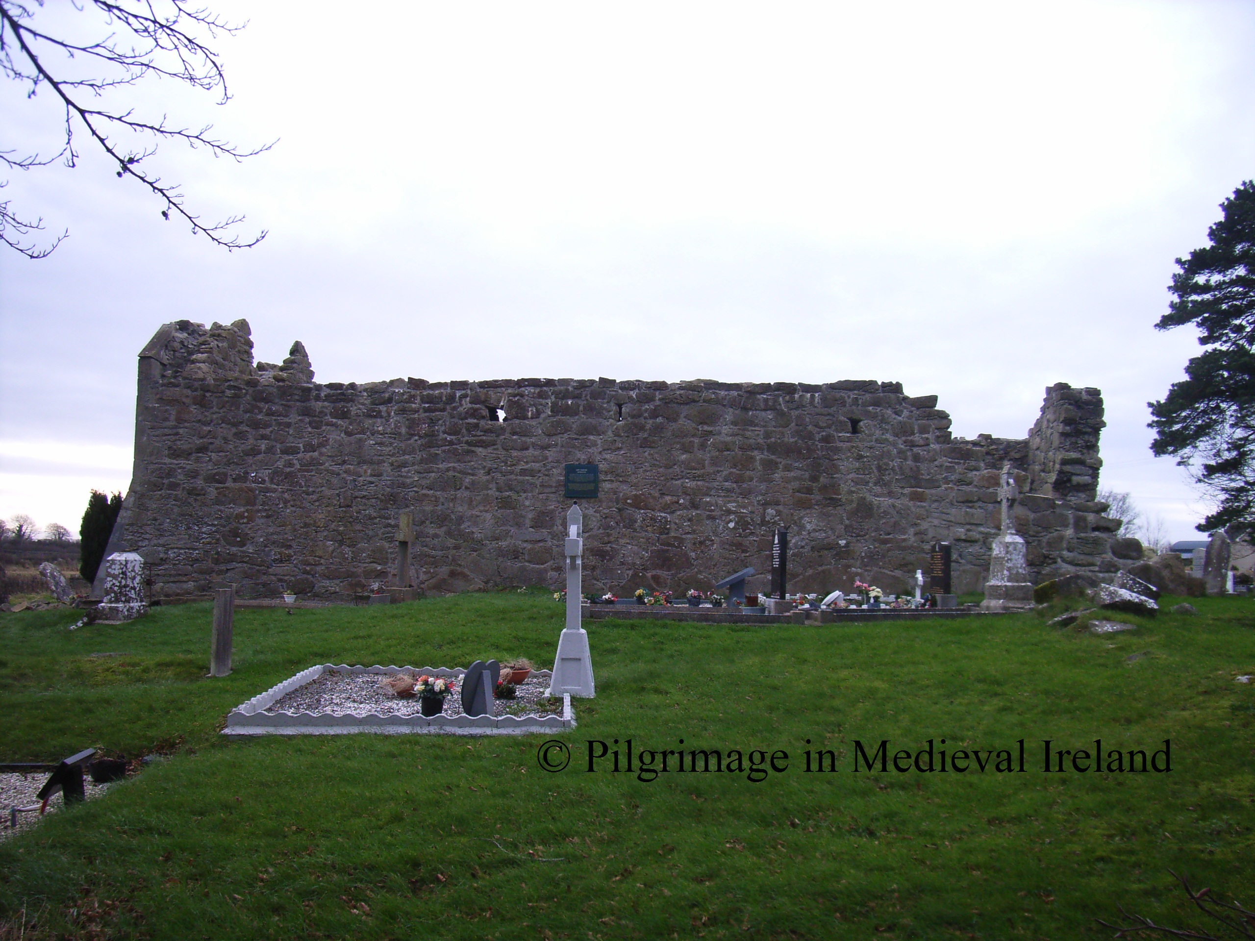
From here the pilgrim walks past the 19th century Church of Ireland to Station 5, located at the corner of the  old church. The pilgrim  recites 7 Our Fathers, 7 Hail Mary’s and 7 Gloria.  The pilgrim  then walks  around St Gobnait’s church 4 times, reciting at each  circuit,  one decade of the Rosary.

20130211_141859

Pilgrim’s doing rounds of the church.

The pilgrim then enters the interior of the church. Station 6  is located  at the east gable of the church.  The pilgrim recites 7 Our Fathers, 7 Hail Mary’s and 7 Gloria .

20130211_141501

Station 6 in the interior of the church.

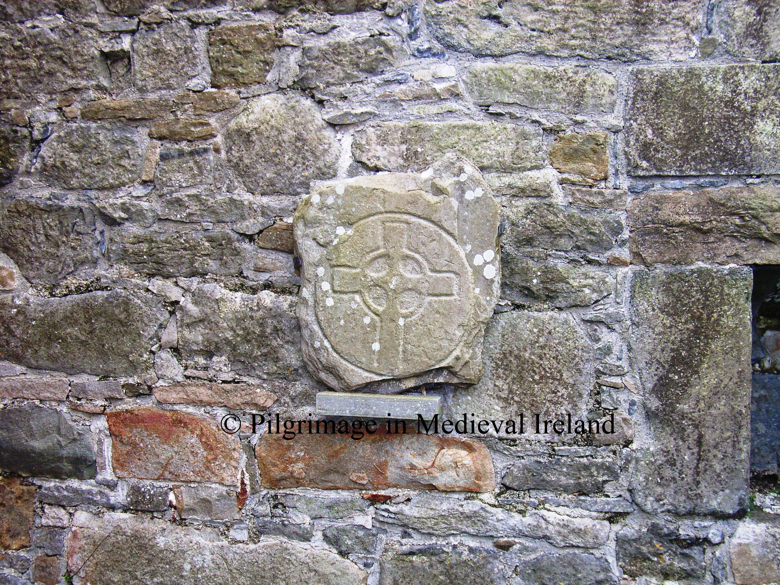
Modern pilgrims have left there mark within the church. There are statues placed in putlog holes ( small square holes used to hold wooden beams,  used in the initial  building of the church) some of the stone in the fabric of the church and   two 19th century grave stones have  had  crosses incised on them.

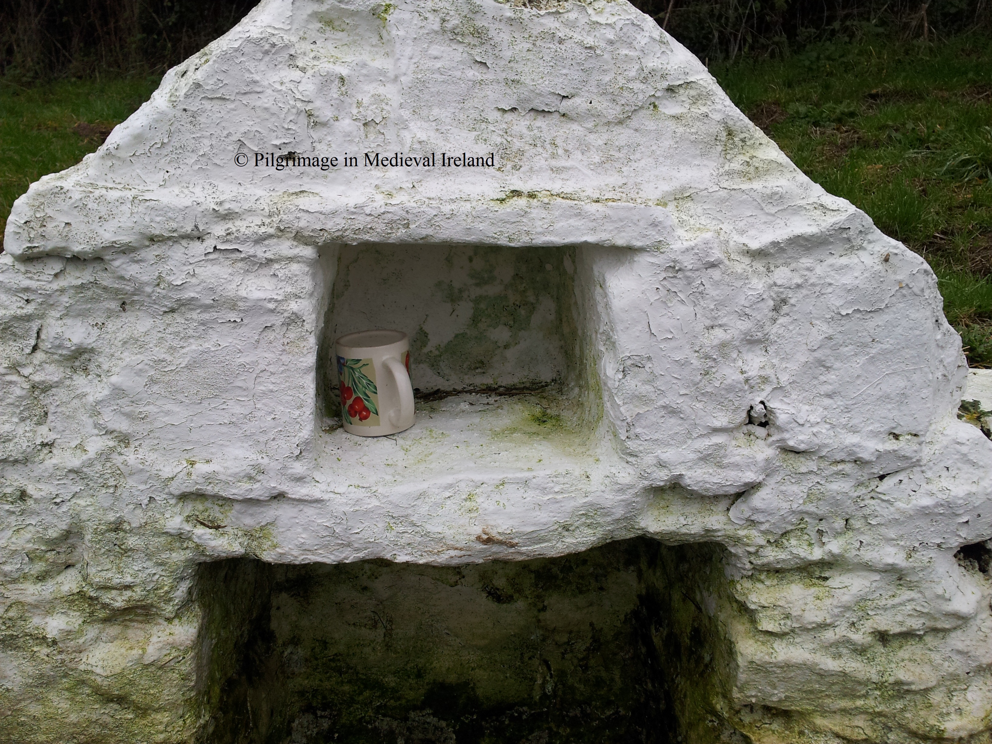
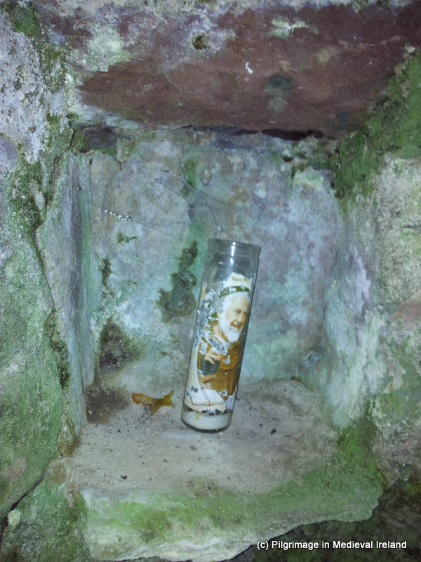
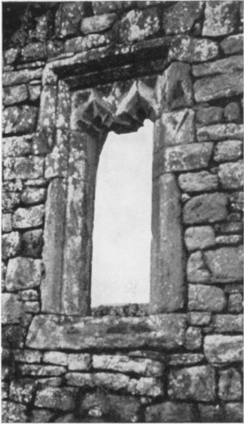
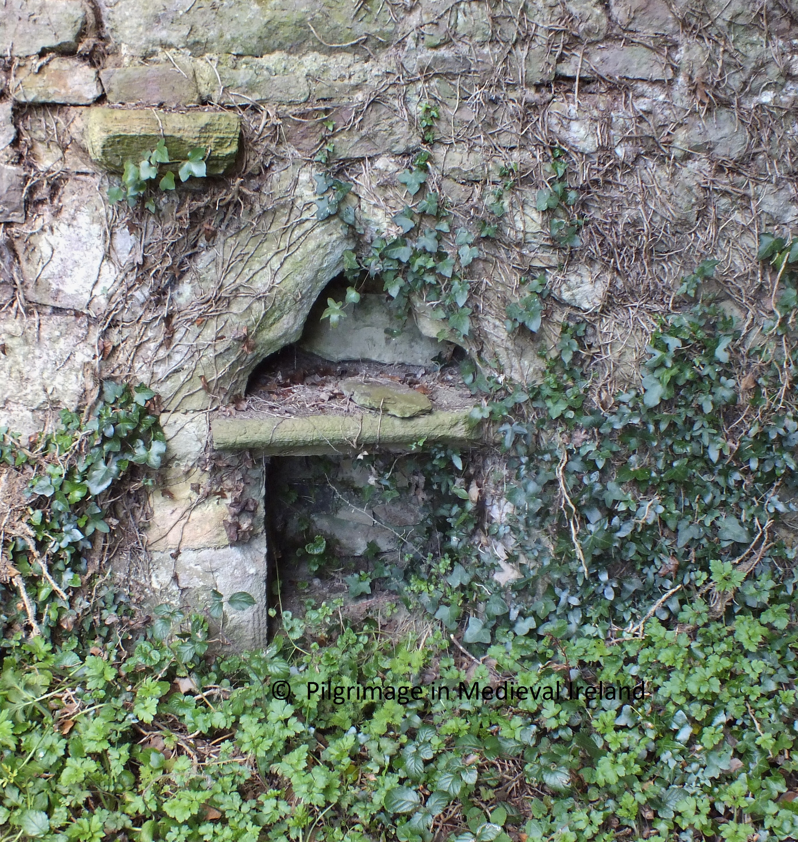
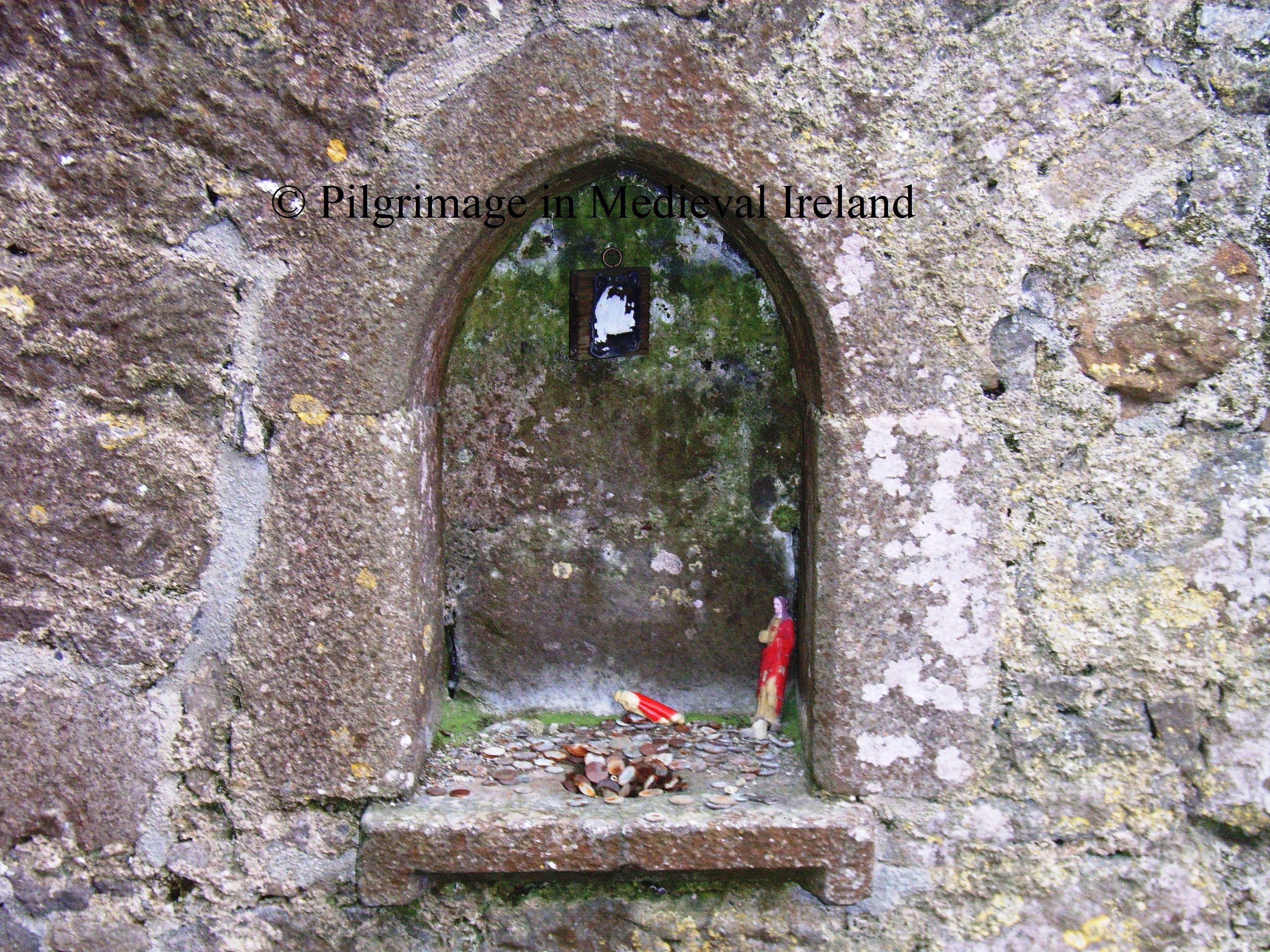
The pilgrim then moves on to station 7, located at the window at  east end of the south wall of the church. A  rectangular recess (cupboard) has been filled over the years by pilgrims  with statues and beads and other religious memorabilia.  The pilgrim recites 7 Our Fathers, 7 Hail Mary’s and 7 Gloria.
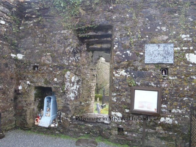
OLYMPUS DIGITAL CAMERA

Station 7

On completion of prayers  the pilgrim reaches out through the window and makes the sign of the cross above the top lintel on a piece of  medieval sculpture known as  Sheela-na -gig. Sheela  are  figurative carvings  of naked women, usually bald and emaciated, with lug ears,  squatting and pulling apart their vulva.  These carvings are found many medieval churches, sometimes castle sites in  Ireland and England. There is much uncertainty as to their original function some think, they were used to ward off evil, warn against lust or even fertility figure.

OLYMPUS DIGITAL CAMERA

Window with Sheela-na-gig

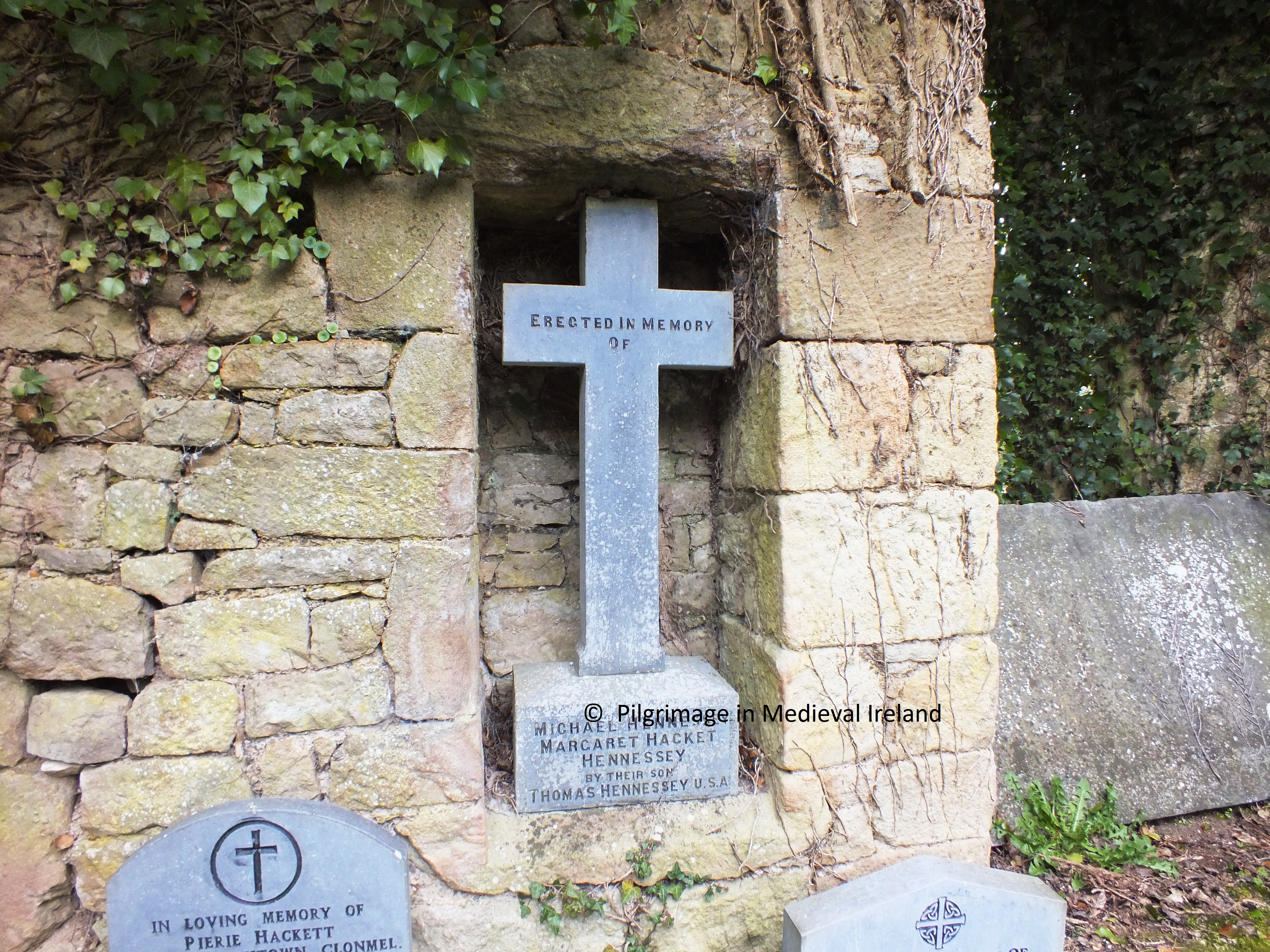
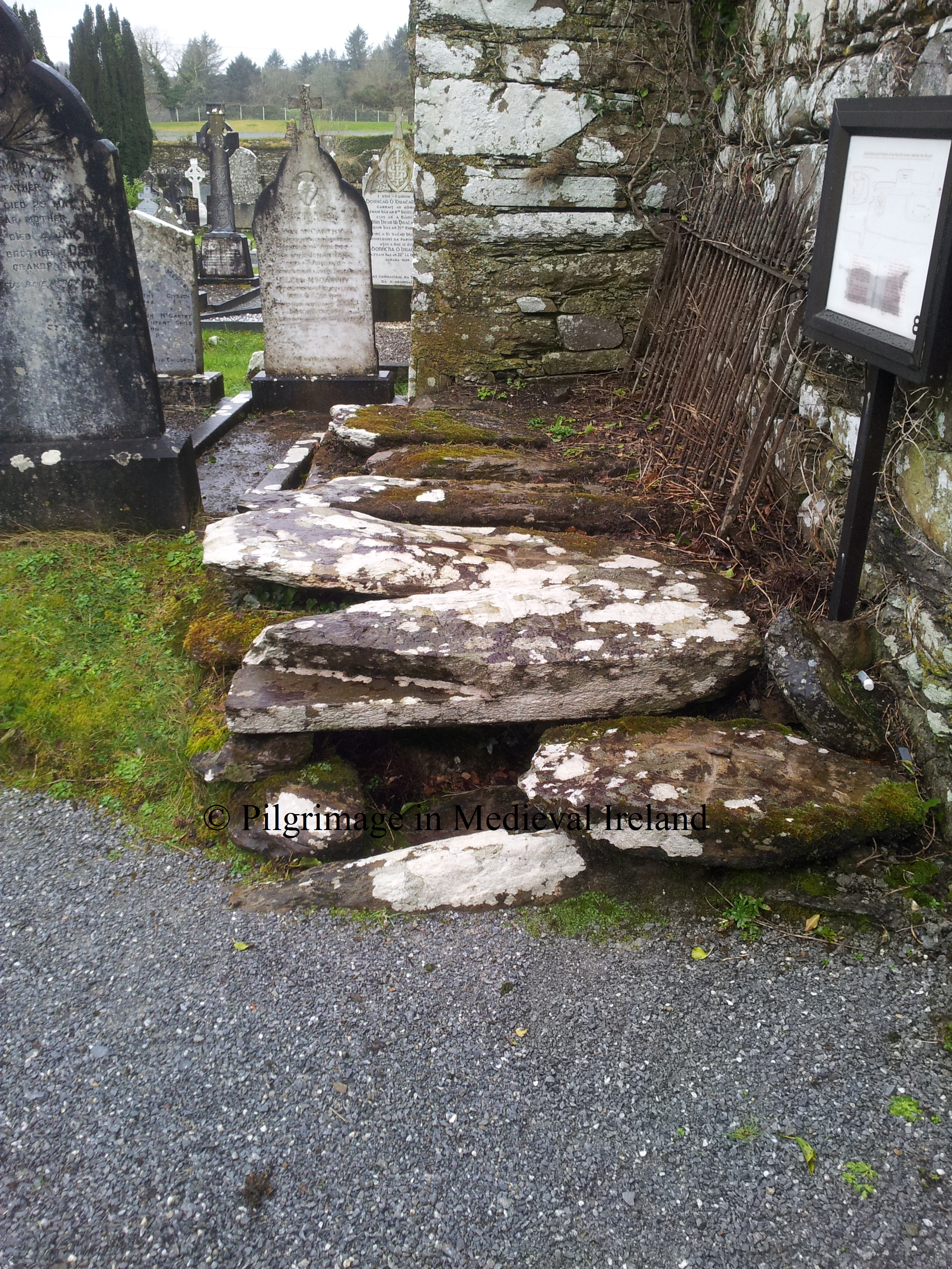
The pilgrim then moves outside of the church to station 8, which is known as the  priest’s grave.  The grave marks the burial of Fr Daniel O’Herlihy  was buried here in 1637. The pilgrim then  recites 7 Our Fathers, 7 Hail Mary’s and 7 Gloria  at this station.

20130211_140812

Station 8, the priest’s grave

Station 9 is at the southwest corner of  the west gable of the church. The focus of devotion  is a polished  agate stone ball, call the bulla. The ball is located in a rectangular recess and  is renowned for its healing power. The  pilgrim  recites  7 Our Fathers, 7 Hail Mary’s and 7 Gloria. Some pilgrims had left a religious medals  and a  piece  of paper probably with a petition to the saint beside the ball.

20130211_143031

Station 9  the polished agate ball surrounded by votive offerings.

There is a folktale associated the with the stone.  Legend has it an invader decided to build a castle in the area. Gobnait could see the castle walls from her church.  Throwing the bulla  at the castle  she razed the castle walls to the ground.  The stone then miraculously returned to the saints hand. Each time the walls of the castle were rebuilt the saint would knock them down again with the bulla. Finally the invaders gave up and move away.

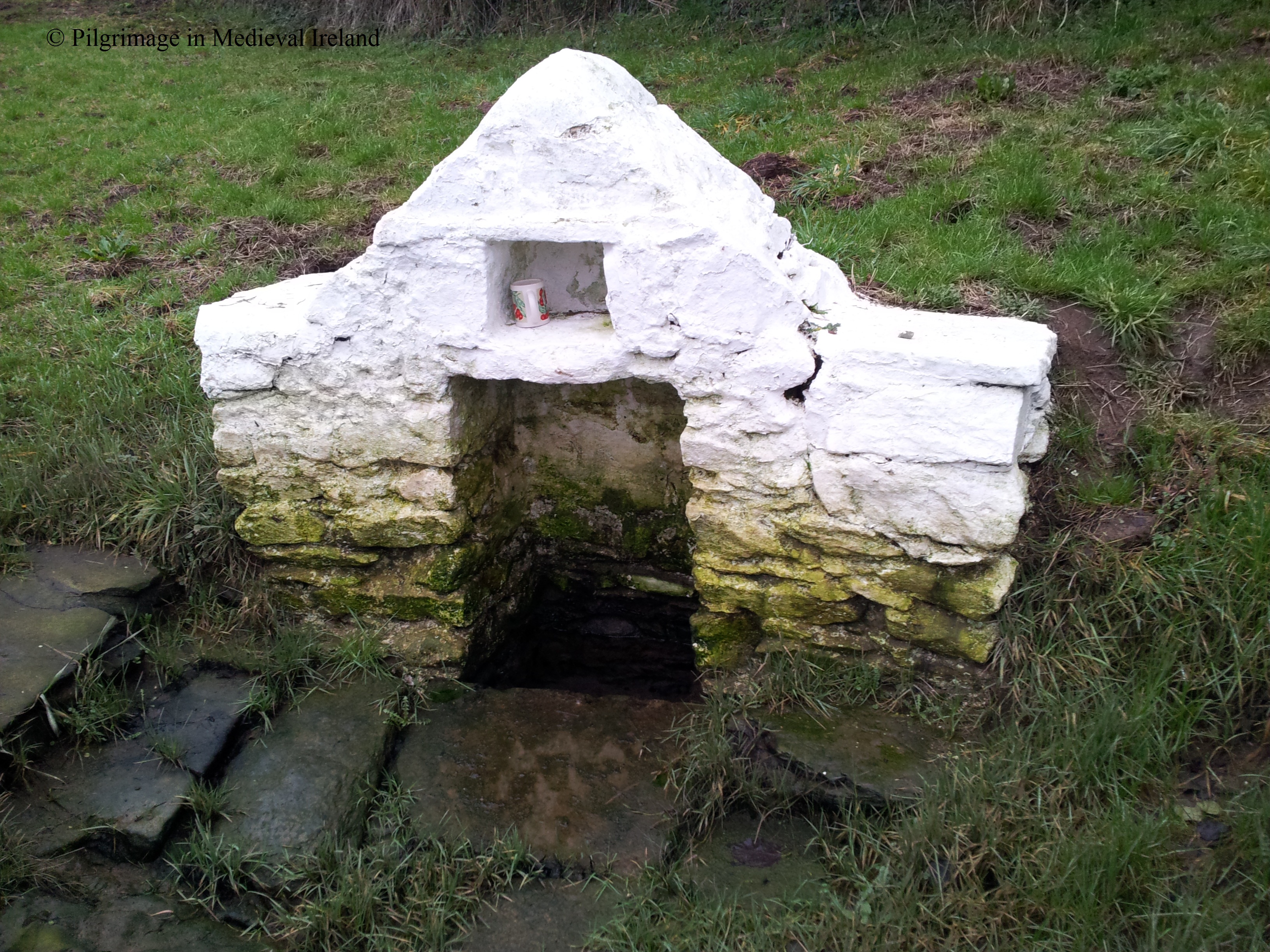
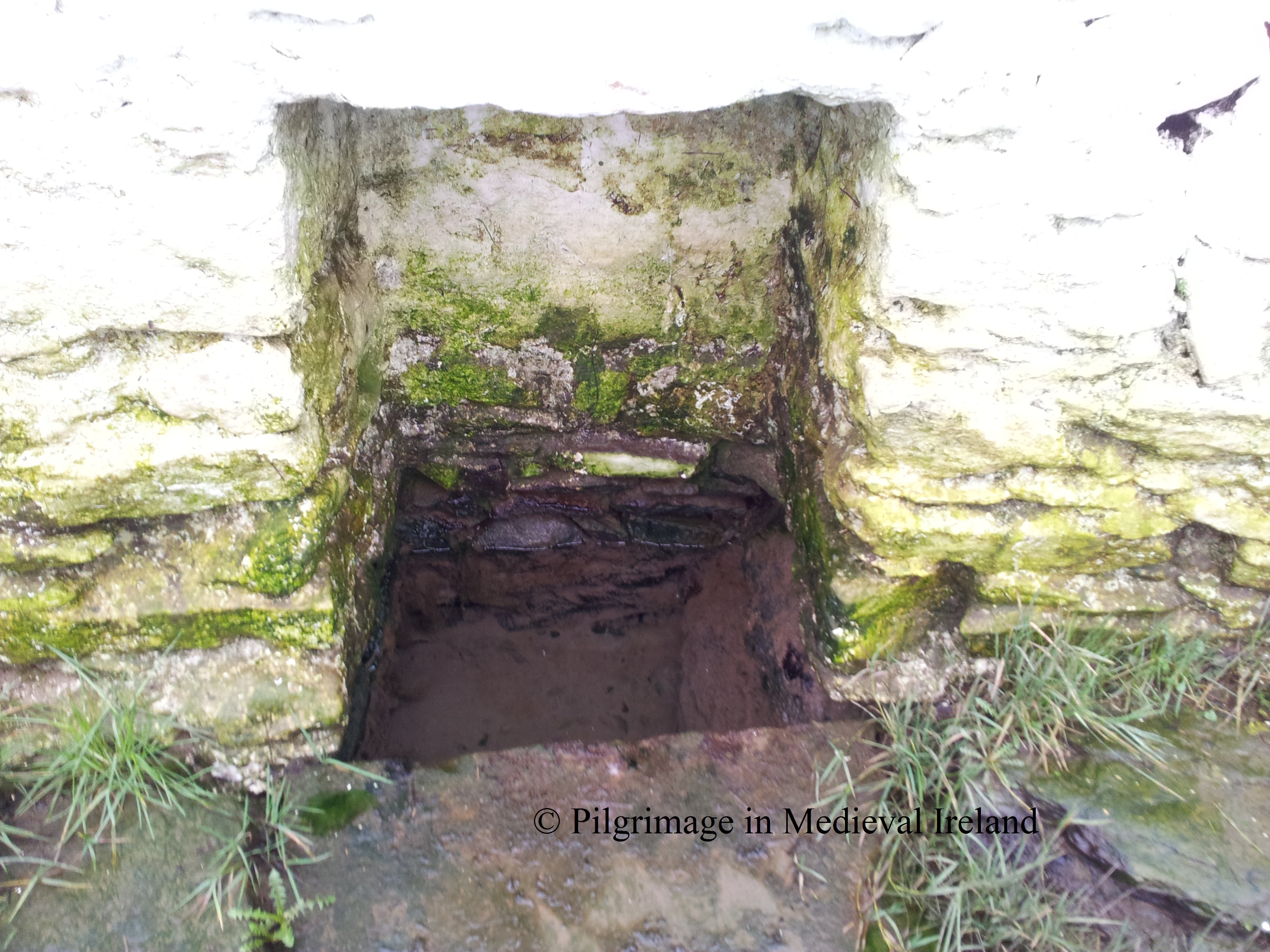
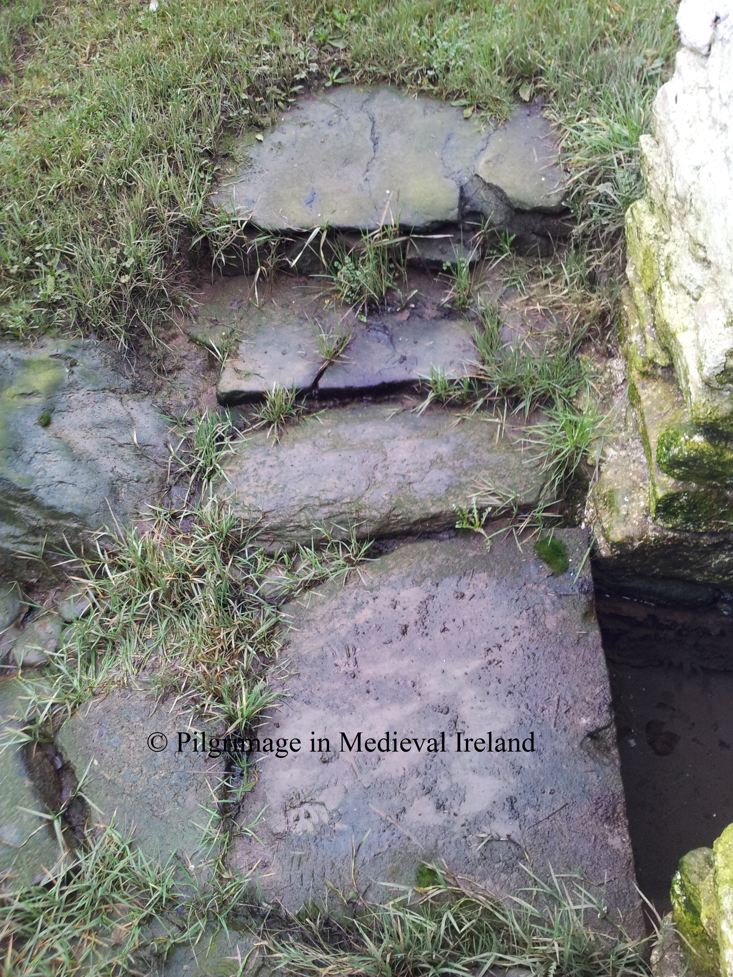
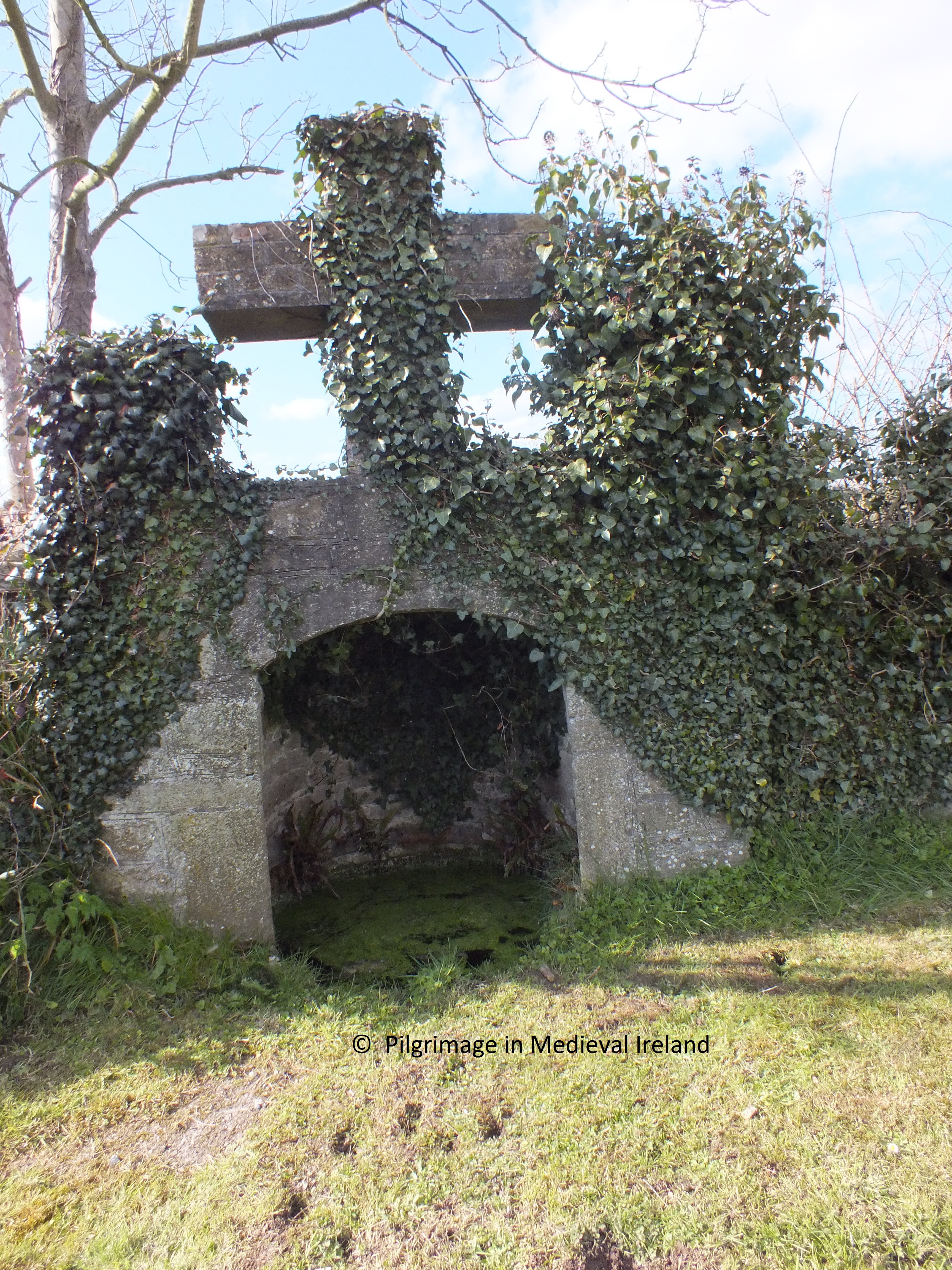
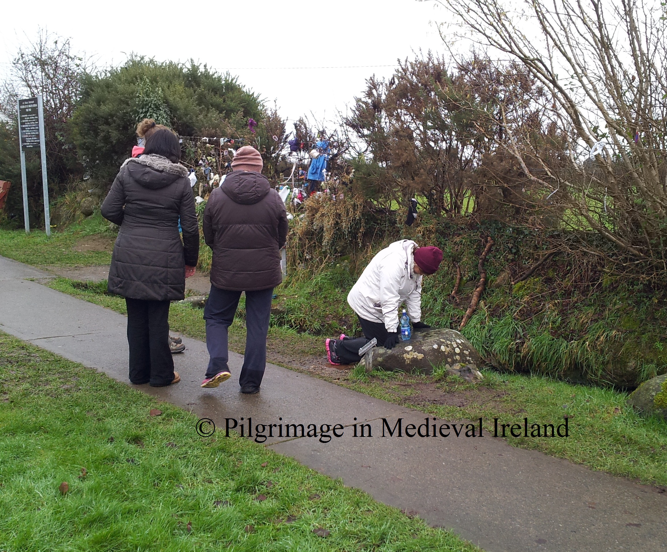
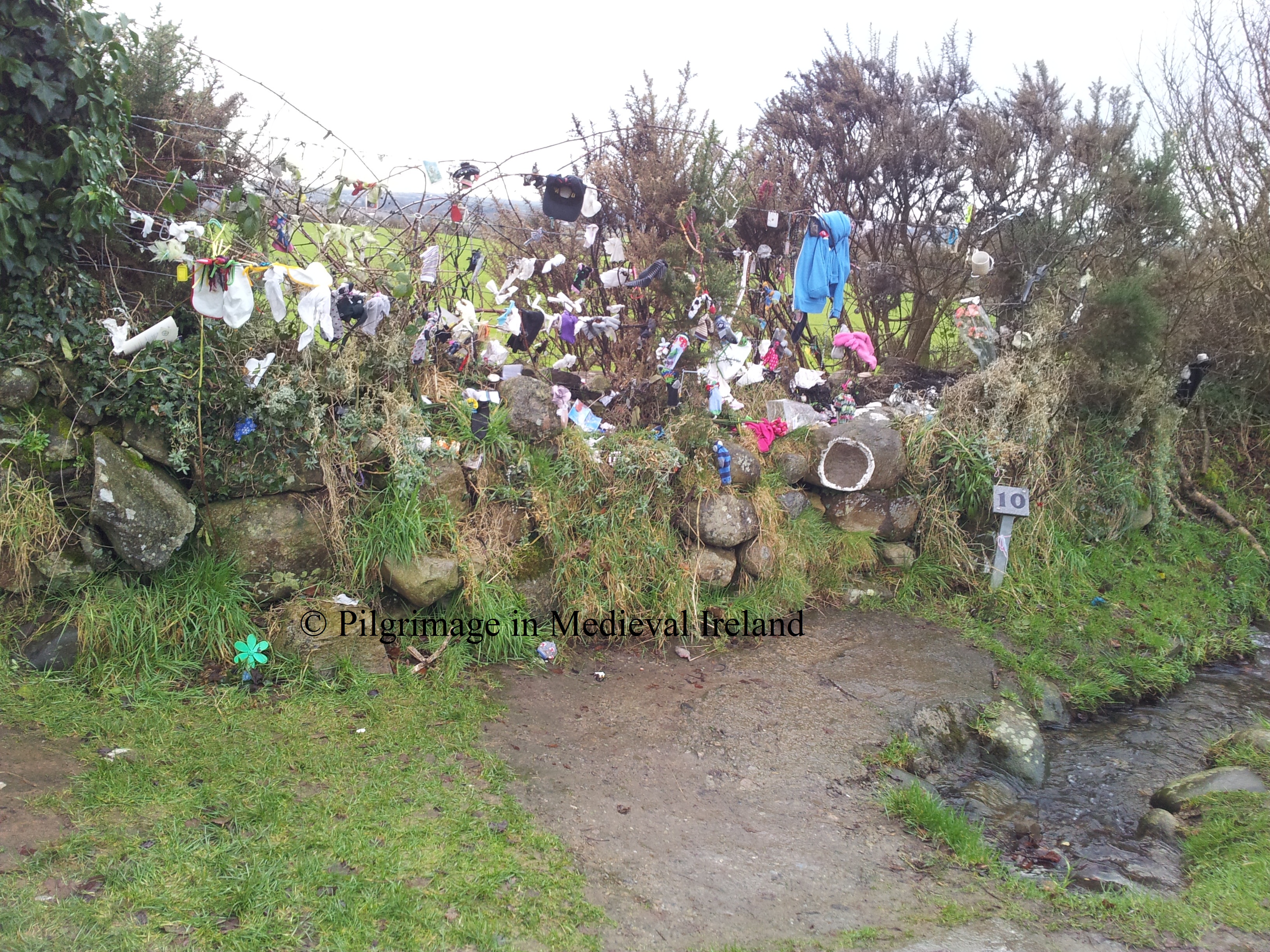
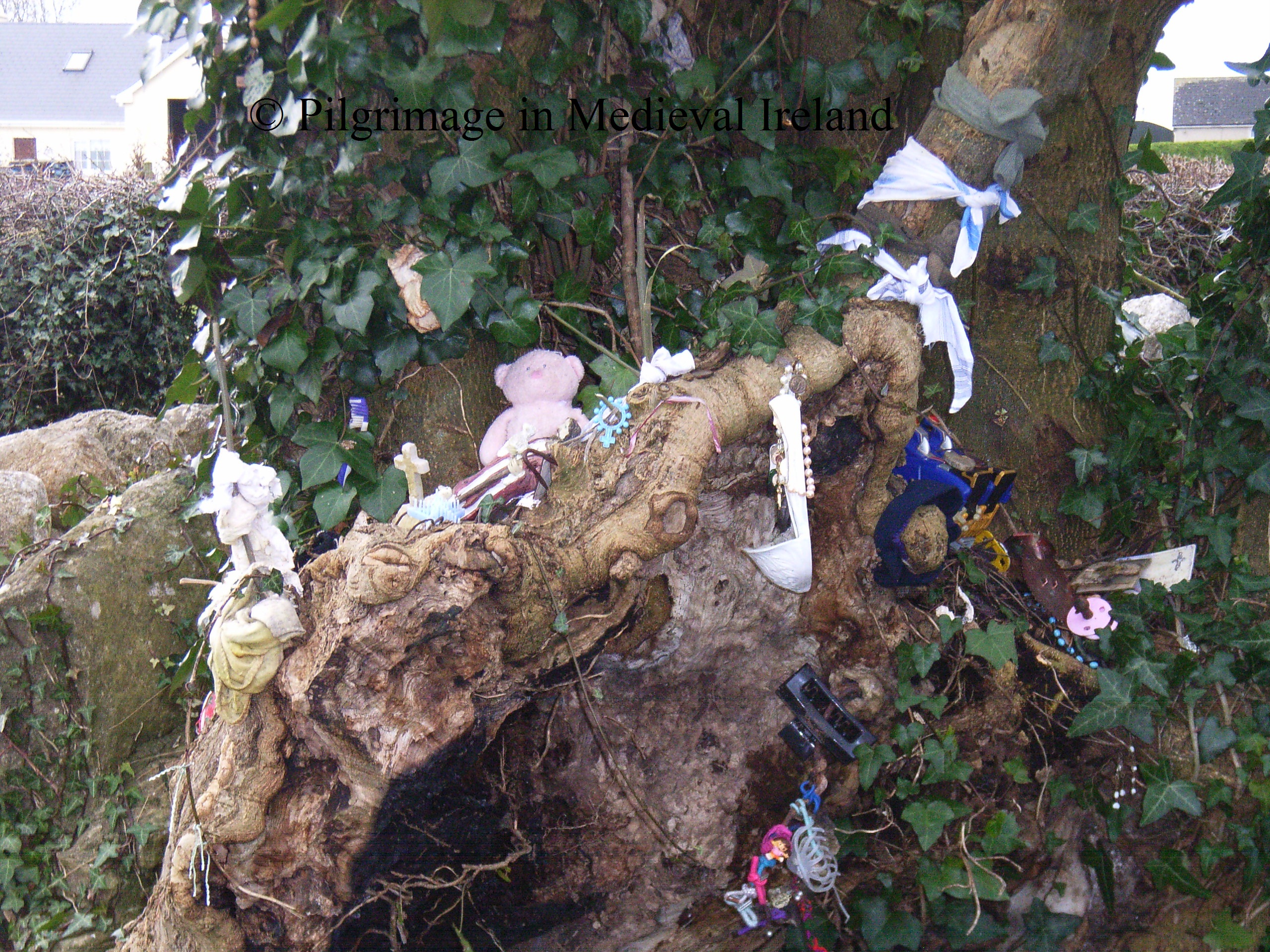
To complete the pilgrimage the pilgrim walks down the road to St Gobnait’s well (Station 10). The pilgrim recites 7 Our Fathers, 7 Hail Mary’s and 7 Gloria,  one decade of the rosary and drinks the water from the well.

20130211_145404

St Gobnait’s well

Like many holy wells in Ireland  St Gobnait’s well is associate with a  rag tree and there is a tradition of leaving votive offerings at this tree. Below is a photo of the tree taken when I last visited here in 2006,  as you can see is covered rags and bead  and tokens left be pilgrims. I think it  looks quiet lovely.   Since my last visit   most of these offering have been removed but a few are still to be found.

RIMG1830

Tree beside St Gobnait’s well taken in 2006.

I came across another book  called Saint Gobnait  of Ballyvourney by  Eilís Uí Dháiligh written in 1983. This book notes that many pilgrims begin there stations with the traditional prayer

Go mbeannaí Dia Dhuit, a Ghobnait Naofa,

Go mbeannaí Muire faoi mar a bheannaím féin dhuit.

Is chughatsa a thána ag gearán mo scéal leat,

Go dtabharfá leigheas i gcuntais Dé dom.

May God and Mary bless you,

O Holy Gobnait, I bless you too,

and come to you with my complaint.

Please cure me for God’s sake.

She also notes the traditional finishing prayer is

A Ghobnait an dúchais

do bhiodh i mBaile Mhuirne

Go dtaga tú chugamsa

le d’chabhair is le d’ chúnamh

(O St Gobnait of Ballyvourney, come to my aid).

Uí Dháiligh  gives instructions for  the pilgrimage as follows (taken directly from her book pages 25-26).

There are five  Stations or Ulacha and each has a particular significance.

I The First Station or Ula Uachtarach is the site of Gobnait’s House. (Stop 1 & 2).

II The Second Station or Ula láir is her grave (stop 3 & 4).

III The Third Station brings us to her Church (stops 5 & 6).

At each of the three stations the pilgrim walks ar deiseal, that is clockwise, and prays. The  customary practice is to say seven Paters; seven Aves; and either seven Glorias or the Apostles’ Creed at the outer ring of each Station which is traversed twice. The same is repeated around the inner circles twenty-eight Paters; twenty-eight Aves; and either twenty-eight Glorias or four Creeds in all.

20130211_142533

Pilgrim praying at Station 5 and a group of pilgrims praying at Station 9 the bulla stone

IV The Fourth Station (Stops 7 & 8) is inside the church where one pater; one Ave; and either one Gloria or one Creed is said. The pilgrim pauses at the south window in honour of the effigy over the window head through by some to be an old image of Gobnait herself.

V The Fifth Station consists of a visit to the Priest’s Grave which lies outside the right corner of the East Gable, where one pater; one Ave, and one Creed are said (stop 9); a visit to the bulla in the south corner of the west gable (Stop 10) and the journey to the well (Stop 11). The pilgrim goes down the main road a little distance and enters the grove where he will find the old Well. Here he says one Pater, one Ave, and one final creed. He drinks the water and says a final prayer.

20130211_145311

Cups and statues left on top of St Gobnait’s well.

Conclusion

Despite the lack of  evidence for pilgirmage in the medieval period, I have no doubt that pilgrims were coming to Ballyvourney from an early date. Gobnait’s reputation as a healer and miracle worker  would have attracted pilgrims from the immediate locality and further afield. We can never know how medieval pilgrims interacted with the shrine, but the  pilgrim rituals would not have been  static and  would have  constantly evolved as evident from the slight variation of the accounts of the modern stations described above.  The  medieval pilgrims to Ballyvourney like those in the 17th , 18th century  would have  come here for much the same reasons as modern pilgrims, to ask for help from the saint and in search of  healing.  Above all it is  the devotion to Gobnait  through the  little wooden  statue  that links the people of Ballyvourney with their medieval forefathers.

© Louise Nugent 2013

References

Chaomhánach, E. ”The Bee, its Keeper and Produce, in Irish and other Folk Traditions’. Department of Irish Folklore.http://www.ucd.ie/pages/99/articles/chaomh.pdf accessed 8/07/2012.

Power, D. 1997. Archaeological Inventory of County Cork: Mid Cork v. 3. Dublin: Stationary Office.

Henry, F. (1952) The decorated stones at Ballyvourney, Co. Cork. Journal of the Cork Historical and Archaeological Society, 57, 41-42.

MacLeod, C.  1946.  ‘Mediaeval figure sculpture in Ireland’ JRSAI Vol. LXXVI, Part II.

Harris, D. 1938. ‘Saint Gobnet, Abbess of Ballyvourney’, JRSAI Vol. LXVIII, 272-277.

Ó’ h-Éaluighthe, M. A. 1958. ‘St. Gobnet of Ballyvourney’, JCHAS Vol. LVII,  43-62.
O’Kelly, M. J. (1952) St Gobnet’s House, Ballyvourney, Co. Cork. Journal of the Cork Historical and Archaeological Society, 57, 18-40.

Richardson, J. 1727. The great folly, superstition, and idolatry, of pilgrimages in Ireland; especially of that to St. Patrick’s purgatory. Together with an account of the loss that the publick sustaineth thereby; truly and impartially represented. Dublin: Printed J. Hyde

http://www.dioceseofkerry.ie/page/heritage/saints/st_gobnait/ (accessed 21/01/2013).

http://www.seandalaiocht.com/1/post/2010/11/st-gobnets-house-ballyvourney-co-cork.html (accessed 18/02/2012).

The modern pilgrimages at Faughart on the feast day of St Brigit

Last week I managed to make it to Faughart, one of Irelands most interesting of pilgrim sites. My visit coincided with  the feast of St Brigit the patron of the area. Faughart  claims to be the birth place of St Brigit and the landscape of the area has a strong cult association with the saint.

dundalk

Map showing Faughart in relation to Dundalk (after google maps)

This has been one of the most difficult posts I have written. It was difficult as  there is so much to say regarding the cult of Brigit,  the history and the archaeology of the pilgrimage at Faughart. After a lot of thought,  I decided to focus on my experience at this years St Brigit’s day pilgrimage and at a later date to write another post on  the origins and history of pilgrimage at Faughart and the cult of Brigit.

Location

Before I begin to describe my pilgrimage  just some words on the location of the site. Faughart is situated about 1-1.5 miles outside of Dundalk. The modern pilgrimage landscape stretches between the old graveyard  at Faughart hill with its medieval church and holy well dedicated to St Brigit  and St Brigit’s shrine a series of station,  holy stones and modern oratory  located along the  banks of the a small stream know as St Brigit’s stream.

new map

Map showing the old graveyard and St Brigits shrine at Faughart

The distance between the two sites is about half a mile.

Faughart is a very popular pilgrim shrine and  pilgrims come here each day throughout the year.  It  is renowned as a place of  healing. The main days of  group/mass devotion  are the 1st of February, the feast day of Brigit and the 1st  sunday in July,  a  day of the national pilgrimage.

My visit coincided with  on the 1st of February. I return also on the 3rd of February when I joined a group of pilgrims walking from Dundalk to Faugart. This second pilgrimage was part of the annual ‘Brigid of Faughart Festival’, a four-day  annual event with lectures, workshops and pilgrimages that  focuses on Brigit . The festival  is a celebration of Brigit, both Goddess and Saint.   For more information  about the event see the link http://www.doloreswhelan.ie/events/brigid-faughart-festival/ .  St Brigit is very important to the people of Louth and  because of her pre-christian origins she bridges the gap between the christian and pagan world. She is a very interesting saint  and I will discuss her cult further at a later date.

St Brigit’s Day at Faughart/pilgrimage part I

Faughart is the other end of the country from where I live, so I travelled up to  Dublin on St Brigit’s eve and headed to Faughart the morning of the 1st of February. I had been to Faughart once before in 2006  but my memory of how to get there was a little rusty.  I decided to stopped first at Dundalk and get directions at the tourist information office .  A big thank you to Sinead who works there for all her help.  I also dropped in to the County Museum where the staff were equally helpful.

I eventually arrived about mid day to St Brigit’s shrine which is the main attraction for modern pilgrims. This site consists of a series of holy stone located on the banks of St Brigit’s stream. The shrine fills  a long rectangular field divide in two by a road. The stream known as St Brigit’s stream runs through its centre.

shrine

Map showing the landscape of the shrine of St Brigit. The shrine is located within the tree covered area and the field showing the stream channel (after google maps).

The  car park was full to capacity  so I packed along the side of the road with the other cars . There was a constant stream of people coming and going . The area of the shrine is quiet large so its easy to underestimate the numbers.  One of the first things I noticed  was   people selling St Brigit’s crosses, candles and  holy mementoes and like any good pilgrim I left with about four St Brigit’s crosses which I have since  distributed among friends and family .

20130201_125554

A vendor selling religious memorabilia and St Brigit’s crosses

Dotted about the shrine  are set instructions for the traditional  stations at the shrine  and   many pilgrims still adhere to them  but others  seem to follow their own  route around the shrine.  As I arrived the day was dry and sunny but it soon turned into  a ‘fine soft day’ Irish code for  a constant light rain.

Instuctions for the traditional stations

Instructions for the traditional stations at the lower end of the shrine

Pilgrimage  begins at the upper shrine.  This is  a lovely place  with lots of  mature trees and a  stream running  through the centre. During the main day of pilgrimage relics of St Brigit (owned by Kilcurry parish) are kept in a simple oratory dedicated to the saint  and many begin their pilgrimage here entering through the main gates and  climb the steps to the oratory past the statues of SS Patrick, Colmcille, Malachy and Oliver Plunkett.

???????????????????????????????

A pilgrim climbing  the steps to St Brigit’s oratory

Pilgrims then pause in front of the oratory to  pray.   For St Brigit’s day a priest in charge of the relic,  is in the oratory during set times  and the  pilgrims can go to  be  blessed by the relic of St Brigit if they wish. The  relic is a  tiny piece of bone (skull)  kept   in a small box with glass lid. The story of the relic  is an interesting one and I will come back to it in another post.

20130201_143632

Pilgrims praying at oratory

The reliquary ( which  holds relic) is place on forehead  of the pilgrim and prayers recited by the priest who asks  St Brigit  to pray for and bless the pilgrims.

The traditional stations begin at the fountain  a stone structure    that reminded me of the corbelled well  (St Brigit’s well) at the nearby old graveyard.  Water from the stream that flows through the site is pipe into the structure  and flows into a large  stone with a hollow  which like many of the other hollowed stones at the site may be  possible bullaun stones.

20130201_143129

Pilgrims praying at station 1

This structure has been renovated since my last visit and  two concrete paths  placed across the once open stream  just opposite it.  At station  1 the pilgrim is to recite one Our Father, one Hail Mary and one Gloria.  I saw many  queue  up here to take the water  home in plastic bottles and to simply bless themselves.

RIMG1587

Station 1 taken in 2006 not the open stream bed in the background which leads to station 2.

Station 2  is located beside station 1 and the pilgrim  must walk a few steps and cross to the  far side of steam. The stream   is railed on either side and the pilgrim must recites one Our Father, one Hail Mary and one Gloria .

RIMG1586

Photo of station 2 & 3 & 4 taken in 2006

Station 3  is a stone located at the center  of the stream bed, the pilgrim recites one Our Father, one Hail Mary and one Gloria here .

RIMG1585

Station no 3 taken in 2006

The photo above shows station 3 in 2006.  Since this date the stone has been incorporated into the concreted  path (mentioned above) to link the two banks.  I wonder was this done for insurance reasons to make the crossing safer for those who are unsteady on their feet ?  Unfortunately it is not as aesthetically pleasing as before, but I suppose it is safer.  The rest of the site seems unchanged.

Once station 3 is complete the pilgrim crosses over  to the other side of the  stream and begins Station 4 . This station is  at the modern looking celtic cross. Here the pilgrim is to perform 10  circuits  reciting one Our Father, one Hail Mary and one Gloria at each circuit . Most of the people I observed just prayed in front of the cross, although I did see some people do the circuits.

The pilgrim continues south along the east bank of the stream, they pray at the  stations of the cross which are dotted along the bank. Some also stop and pray at   a grotto dedicated to the Our Lady.

Pilgrims praying at the stations of the cross

Pilgrims praying at the stations of the cross

This route takes the pilgrims  across the road   into the lower shrine which is much more open and landscaped. One lady I meet told me in the past there was a lot more bushes and trees here which she felt gave more privacy for pilgrims praying.

As one enters the lower part of the shrine  on the left is a small chapel.  According to the noticeboard on the 1st of February mass was said here at 10.30, 12.00 and 13.00.

The stream  continues down slope.  I also notices a modern well type structure built over the stream. Pilgrims  made their way down slope  stopping  to pray at the stations of the cross and some at the well structure  and some people also collected water from here in plastic bottles.

pilgrims saying stations of the cross

Pilgrims at the lower shrine

Pilgrims begin station 5  at the point  just where the stream turns and heads east  along the field boundary wall  of the shrine.  Again the   pilgrim recites one Our Father, one Hail Mary and one Gloria .

OLYMPUS DIGITAL CAMERA

View of pilgrims at stations 5-10.

Close by is station 6,  which is  known as the  hoof stone.  Again pilgrims recites one Our Father, one Hail Mary and one Gloria.

Hoof stone

Station 6 the hoof stone

Stations 6-10 are all invested with origin legends connected with St Brigit.  If I remember correctly, folk tradition states that St Brigit was living with her sister at Faughart but a young prince wanted to marry her and wouldn’t take no for an answer. One night she decided to run away to escape him  and  as she was making her way out of Faughart following the stream the prince  who had heard about her leaving came  in pursuit.  Brigit knelt down to pray beside the stream leaving her knee prints in the stone. She then plucked out one of her eyes to make herself less attractive and unrecognisable.   The prince caught up with her but didn’t recognise her and the hoof mark of his horse was left behind in the  stone known as the hoof stone.

Station 7  is  the knee stone, which marks the spot where the saint knelt to pray. It is a large rock with two hollow. The pilgrim kneels in the hollows of the  stone  and  then on top of the stone while reciting one Our Father, one Hail Mary and one Gloria .

knee stone

Station 7, the knee stone

Others  simply  recite their prayers standing beside the stone.

Pilgrim kneeling in the knee stone

Pilgrim praying in the knee stone on the 3rd February

The pilgrim continues  along the modern path to station 8  which is known as the waist stone . I noticed that some pilgrims sat on the stone but most stood by it . The pilgrim is required to recite one Our Father, one Hail Mary and one Gloria .

waiste stone

Station 8 the waist stone

Station 9  is called the eye stone ( this supposed to be  the eye the saint plucked from her head, a similar stone was said to have existed in Dunleer). The traditional prayers require  here are ten circuits of the stone while reciting one Our Father, one Hail Mary and one Gloria at each circuit.

Eye Stone and modern Grotto

Eye Stone and modern grotto

I saw some pilgrims sit/lie on the stone  they then blessed themselves with water from a little hollow on top of the stone.

Pilgrim sitting on eye stone

Pilgrim sitting on eye stone 3rd February

Many pilgrims also pray at the  modern grotto beside this stone. The final station (station 10)  the head stone  is a large stone with a hollow whose outline has been pained in white.  The stone is part of the boundary wall and rags and tokens, the same type of thing you get on rag trees, are tied onto the fence  in the boundary bank. The pilgrim places his/her  head in the stone  and recites  one Our Father, one Hail Mary and one Gloria.

20130201_142209

Station 10 the head stone.

This ends the  pilgrimage at St Brigit’s shrine and stream. I noticed that many pilgrims stated  at the headstone and ended their prayers at the eye stone, reminding me that pilgrim rituals are fluid.  I will delve more into the history of the shrine and these stones in my next post on Faughart.

St Brigit’s Holy well on Faughart hill

St Brigit’s well is located in the nearby graveyard,  it is also a focus of pilgrimage in the area, although on a much smaller scale. I  headed up to the old graveyard at Faughart hill around three. There were significantly fewer people here but again there was a constant flow of people coming and going .  Buckets  of water from the well had  been place outside the walls of the graveyard  for those too busy to go to the well.  I saw several people arrive  armed with plastic bottles , some filled them from the buckets and then left .  Others went into the graveyards and followed the path down to the holy well  located below the ruins of a 12th century church.

OLYMPUS DIGITAL CAMERA

Water from St Brigit’s well by the wall at Faughart old graveyard

During the 19th century pilgrimage at  the well was much more popular.  The well  a corbelled structure is entered by walking down steps (added in the 1930’s) .

St brigit's well

St Brigit’s well.

Pilgrims continue to come here and take water away with them and  pray. The  bushes that surround the well are covered with rags and rosary beads showing that pilgrims still come here to ask  Brigit for help.

Local lady carring water from the well

Local lady carrying water from the well

Also at the site  are two  penitential  station  which were visited by 19th century pilgrims, again I will discuss these further in the next post on Faughart. One is a circular mound surrounded by kerbing  is called St Brigit’s pillar. The base of a medieval cross sits on top of the cairn.

20130201_152610

St Brigit’s pillar

The second station is a horse-shoe shaped   mound with two upright stones at the entrance, it is known as  St Brigit’s  bed.

OLYMPUS DIGITAL CAMERA

St Brigit’s Bed

I didn’t see anyone visit these  two stations  during my time here, generally people left after visiting the well and collecting  their water. A local man I meet, told me that no one does prayers at them anymore.

So I headed back for some food and  came back again to Faughart for part II of my pilgrimage  the annual torch-light procession.

Torch Light proscession/pilgrimage part II

The procession  is a night walk  from the old graveyard at Faughart to the shrine of St Brigit. This year it began at  8 o’clock and I roped my friend Nikolah  into coming along. It had been a wet day and but when we arrived at Faughart Hill  the night was cold with a clear sky full of shining stars. The lights from Dundalk and the motorway below were spectacular. The procession is really an event for the local community to connect with Brigit and people of all ages from tiny tots to the elderly were there. Everyone was in good spirits despite the cold and I spotted some very fancy lanterns.  The procession began with the  priest reciting a prayer to St Brigit, then   two men carrying a large processional St Brigit’s cross and flags set off  down the road,  those carrying the reliquary containing the saints relics fell in behind and then everyone else assembled on the hill  fell in behind them  and we headed off on our pilgrimage.

20130201_201025

  Finding our way in the dark wasnt as difficult as I had thought. There was something very relaxing about walking under the stars. You have to be aware of those around you so you didn’t trip or trip someone who was walking at a slower pace. Prayers and songs were sung and the journey  felt like no time at all.  When we  arrived at St Brigit’s shrine there were many people already  there. We all lined up along the banks of the stream at the upper shrine , while the reliquary was brough to the small shrine mentioned earlier. The parish priest  stood at the shrine gave blessing to all present and he also blessed the St Brigit’s crosses , which most people had brought along with them. Prayers were recited in English and Irish. It’s hard to gage how many people were there but there were 100’s  one estimate  I heard was 600 people.  There were also guardaí present to make sure there were no traffic or crowd control problems. The atmosphere was great and I really enjoyed  the experience.

Pilgrims at the end of the Torch light procession

Pilgrims at the end of the torch light procession

Many of those present  proceeded to do the pilgrim stations in the dark before heading home. The procession was one of the nicest pilgrim experiences I have  had. It has been running for the last 37 years . Night pilgrimage and vigils were very important in the medieval world and it is really lovely to see this  tradition being adapted  in the modern world.

Saturday was my day of rest  but Sunday was the last  day of  my pilgrimage.

Sunday Imbolc Festival Pilgrimage walk/Pilgrimage  part III

The final part of my pilgrimage to Faughart took place on Sunday the 3rd.  As I mentioned earlier this pilgrimage walk from Dundalk to Faughart was organised as part of the  St Brigid of Faughart Festival 2013 (link to their site in references). The walk was  followed by a historical tour of Faughart given by local historian Pat O’Rourke.

The walk began at the peace shrine at Linenhall Street in Dundalk.  The group was made up of around 20  women, our local historian Pat O’Rourke and a sheepdog called tara .  I couldn’t have met a more lovely bunch of people. The walk leader Dolores Wheelan, one of the organisers of the Imbolc festival  gave an introduction to the walk and the ethos of the  pilgrimage.  A candle which had been brought from Kildare on St Brigit’s eve  was lit in front of the peace monument  and was then  carried at the front of the group  as we walked along.  Each member of the group  got to carry the torch and lead the group.

20130203_101214

The walk  was about 1-2mile to shrine. This would have been the traditional route chosen by pilgrims from Dundalk to Faughart. The road heads out of Dundalk and  crosses over the motorway by a foot bridge.  Members of the group were free to  engage in the pilgrimage walk as  they wished, some chatted to  each other, others walked in silence , while some chanted a simple  line Oscalite mo Chroí  (Open my heart). We were asked simply to think of Brigit and any prayer that we had  for her while walking along  and to be respectful to other people.

20130203_105929

Once we crossed over the motorway we were walked along quiet county roads.  As we neared the shrine  most people around me  fell silent and were deep in contemplation.

20130203_112012

Pilgrim leading group  while carrying the  light of Brigit

When we reached Faughart  we were treated to hot tea, coffee and soup and  tea  brack.  A very welcome treat for the pilgrims.  After our refreshments Dolores  brought us around the lower shrine  and explained the significance of all of the holy stones and we were all given the opportunity to do our own pilgrimage around the shrine.

The final stage of our  journey was  a historical tour of  old Faughart given  by Pat O’Rourke .  Pat explain about Faughart’s past, from pre-historic to modern times. He  brought us around Old Faughart graveyard  and pointed out many interesting  facts about the well, the church and the penitential stations.

20130203_140817

Historical tour of old Faughart graveyard

I must say I had a very enjoyable day. The group also called my attention to a new pilgrimage walk planned for the summer called Slí Bhride.

During the summer Faughart will  be part of a new exciting pilgrim walk.  A new pilgrimage walk is planned on the 7th July -15th of July  2013  called Slí Bhride. The walk will start at  Faughart in Co. Louth, pass through Louth, Meath and Kildare and end in Kildare Town. I will keep you all posted as I find out more  but  if anyone is interested in finding out more check out  www.brigidsway.ie

or email

eolas@doloreswhelan.ie

I am going to write more about Faughart in the coming months so watch the space

© Louise Nugent 2013

References

http://www.doloreswhelan.ie/events/brigid-faughart-festival/( accessed 2/02/2013).

http://www.createlouth.ie/brigid-festival-dundalk (accessed 2/02/2013).

http://j2.catholicireland.net/mass-times?task=churchbyparish&ParishID=1300 (accessed 25/01/2013).

http://www.faughart.com/local-history-page26988.html (accessed 27/01/2013) excellent source for the history of the site.

Save

Medieval Pilgrimage at Lemanaghan, Co Offaly

The ecclesiastical settlement of Lemanaghan is one of Co. Offaly’s hidden treasures. There  is so much to say about the architectural remains and the history of the site  and of course its founding saint, Manchan.   I am going to  focus on the evidence for medieval pilgrimage at the site .

In early medieval times  Lemanaghan was  located  in the territory of the Delhna Ehtra tribe close to the border of the territory of the Delbna Ethra  and the Ferceall.   For the modern traveler it is located along the R436   to the east of the town of Ferbane.

Map of Lemanghan showing  the monastic remains from Bing maps

Map of the ecclesiastical remains a t Lemanghan from Bing maps (http://www.bing.com/maps/)

Lemanaghan was founded in the 7th century after King Diarmaid   son of Aedh Sláine, granted the land of the territory of Tuaim-nEirc (Doimerc) to Clonmacnoise following his victory at the battle against Guaire King of Connaught in 645/646.  It appears  that Manchan a monk of Clonmacnoise, founded a sister monastery  here  at Liath-Manchain  ” the grey place of Manchan” (Lemanaghan is the anglicized version ). There are a number of traditions  concerning the geneology St Manchan.  One tradition  suggests he was a member of the Ulaidh of Ulster while another suggest he a was a member of the Eoghanachta of Munster and another that he  was from Wales.  The saint was credited with writing many poems during his lifetime .  Manchan is also associated with the Mohill in Co Leitrim where local tradition holds he  founded a monastery here before heading to Lemanaghan. Manchan died in 664/665  having caught the yellow plague that raged through the country. This is the same plague which killed St Féichín of Fore.

RIMG1613

St Manchan’s church at Lemanaghan

The modern landscape of green fields that surround Lemanaghan  would not  have been the lanscape encountered by  early and later medieval travelers & pilgrim’s.  The modern landscape surrounding Lemanaghan  is  a product of  modern intensive peat cutting.   Originally the monastery  was  founded on a  natural island of dry ground surrounded by  raised bogs. Monahan writing in 1863 describes the site as follows;

Standing on a low swell, an armlet of well-reclaimed bog, it gently rises above the extensive moors with which it is almost surrounded.

This doesn’t mean the Lemanaghan was isolated  from the rest of the world. It was linked  to other settlements in the area in particular Clonmacnoise , and the wider world  through a series of bog roads and tracks . Excavations carried out in the surrounding landscape have identified several roads and tracks many  dating to the 6th and 7th centuries when the monastery was founded.  The excavations also show that roads and tracks were being built and repaired around Lemanaghan up to the 17th century, suggesting it was a focal point in the landscape throughout the medieval period.  Thus its location was not a barrier to pilgrims and visitors.

Little physical evidence remains of the early monastery with the exception of a number of early medieval cross slabs ( two of which are found with St Manchan’s church and ten others housed in national school), a large  bullaun stone (beside the holy well) and a holy well dedicated to St Manchan.  The   annals  list the names of several abbots of the monastery ( in the years  717, 767, 792, 853, 893, 1205). The fortunes of the monastery declined in the later medieval period.  By 1302-6  Lemanaghan became a parochial church.  The papal taxation records,  record that there were no returns from the vicarage of Lemanaghan as it had been ‘laid to waste by the ravages of war’.  St Manchan’s Church  continued in use probably until 17th century and  by 1682-5, the church was recorded as being in a ruinous condition, with church services being held in a nearby house.

RIMG1615

Early medieval cross slab within St Manchan’s church

The main monastic complex  was located at the site of   the modern graveyard. All that  remains  today of this once vibrant monastery  are  two structures called St Manchan’s church and St Manchan’s house.

St Manchan’s church  was built-in  two phases, the  west end dates to the 12th century.  Further building work was carried out in the 15th century at the eastern end .  The  western end of the building  is the oldest with  traces large limestone blocks in its  lower walls and a large Romanesque doorway of 12th century date marks the  entrance in west gable.  A  round-headed Romanesque window also survives.

RIMG1627

Romanesque doorway at St Manchan’s church

Little remains of the second structure called St Manchan’ house, with  only the foot prints of the foundations   visible, the Archaeological Inventory of County Offaly suggest that it is  likely contemporary with the 15th century section of St Manchan’s church.

St Manchan's house

A third church  known as St Mella’s cell,  is located  approximately 350m to the  east.  The site is connected to the main monastic centre  by a narrow paved causeway. Local folklore recounts  that  depressions visible   in the surface of the paving stones of the causeway were  caused by  the saints cow.  St Mella was Manchan’s mother and  tradition suggest she  live here as an anchorite. The present church may have been built on the original cell.

RIMG1636

Causeway leading to St Mella’s Cell

St Mella’s cell  is quiet small measuring  5.5m x 3.1m internally. The walls are  0.8m thick  and constructed  of large  what look like really large cut stones.  These stones are in fact thin slabs set on edge  in the manner of facing stones and the core of the wall is filled with stone rubble. This type of building technique is common in pre-Norman Irish church building.  The church is surrounded by  its original rectangular-shaped enclosure (43m E-W by 35.5m north-south).

RIMG1646

Evidence for Pilgrimage

So what can we say about pilgrimage at Lemanaghan in medieval times?  Pilgrims came here to venerate St Manchan and the anniversary of  the saints  death on the 24th of January would have had a special appeal for pilgrims.  Pilgrims  probably  first began coming here following Manchan’s death.  Given Lemanaghan   proximity and close connections to Clonmacnoise,  the site likely attracted pilgrims heading to Clonmacnoise and to other sites such as Durrow and Rahan, acting as a secondary shrine.  Manchan was probably buried here we have no way of knowing if the saints grave had an appeal for pilgrims.  From the 12th century  onwards  a reliquary known as St Manchan shrine   would also have attracted pilgrims.

The shrine was   commissioned by High King of Ireland, Turlough O’ Connor and  was reputed to house the bones of St Manchan  and manufactured at Clonmacnoise. The annals for 1166 state

The shrine of Manchan, of Maethail (Mohill), was covered by Ruaidhri Ua Conchobhair , and an embroidering of gold was carried over it by him, in as good a style as a relic was ever covered.

This reference likely refers to the Lemanaghan shrine  although it is possible it may refer to second shrine now lost, that existed at Mohill.  Fragments of bone possibly from the saint were found within the shrine.  From the sparse references that exist the shrine appears to have  been  housed near the high alter of St Manchan’s church untill  as late as  the 17th century. It was later moved to the parish church at Boher where it remained until it was stolen last year. Thankfully the shrine was recovered the next day. St Manchan’s shrine is one of the finest  medieval reliquaries to survive in Ireland and its loss would have been significant.

St Manchan’s shrine is what is known as a   house- shaped shrine and resembles the pitched roof of  church or oratory. The shrine  is made of yew wood ( 48cm tall by 40 cm wide by 61cm long) and decorated with highly decorated bronze figures and bosses and  sits on four feet. The shrine was portable  which meant it could be  carried in processions. Four metal loops are found at each corner which allowed wooden poles to be treaded through.  A reliquary procession may have formed part for the pilgrim rituals on  the more important days in the pilgrim calendar such as the saints feast day. It likely that the date of the translation of the saints relics to the shrine would also have been a special day in the pilgrim calendar.

In modern times a piscina   (a shallow basin placed near the altar  of the church  used for washing the communion vessels), at the east end of the south wall of St Manchan’s church   became  a point of modern devotion. Votive offerings such as  coins, pins  and a small plastic statue of Christ are left  behind by modern pilgrims.

Piscina fille with votive offerings

Piscina with votive offerings

Apart from the  aforementioned reliquary, pilgrims would also have visited St Manchan’s holy well.  According to  Monahan writing in 1886  there were  three wells at the site

to which the blind, lame and persons afflicted with other chronic diseases, come on the anniversary of the patrons saint’s death.

Today only one well holy well  remains, it is located close to  the main monastery beside the paved causeway  that connects the main monastic site with  St Mella’s church.  A large bullaun stone and rag tree are also associated with the well.

RIMG1628

Bullaun stone at St Manchan’s holy well

The wells at Lemanaghan may have been a focus of pre-Christian devotion and were christianised when the monastery was founded. The origin  legend for the well tells that  St Manchan struck a rock with his staff and water poured forth.  Another version of the tale states that an existing  well  was blessed by him.  Today people  visit the well throughout the year but the 24th of January the saint’s feast day still has a special appeal.  The  present  well, a natural spring,  is a product of   restoration work carried out  during the 1930s.  Four grave slabs in upright positions were revealed, set out in a cruciform pattern. The spring is enclosed by a stone wall ( key hole shaped) and accessed by series of steps. The surrounding area has been paved. The base of the well is full of coins left by modern visitors to the well.

RIMG1634

St Manchan’s well

The waters of the well are reputed to cure   nearly every ailment is cured , but particularly neuralgia, cancer and warts. The folklore suggests that for a  person to be cured they must apply water to the affected part and walk three times around the well. Beside the well is a misshapen ash tree, covered in rags, handkerchief, rosary beads etc. There is  local  tradition of taking pieces of wood to protect the home.  Similar  practices occur at other sites church as St Moling’s well at Mullinakill Co Kilkenny, where the wood of the tree beside the well is supposed to protect against fire.

RIMG1631

Rag tree beside St Manchan’s holy well

Like most sites we can only get a  glimpse of the medieval pilgrimage tradition  here, through the centuries  pilgrimage has continued and adapted  to the modern pilgrim landscape which focuses on the  piscina within the church and the holy well and rag tree.  I think Lemanaghan was a pilgrimage site in its own right with St Manchan attracting pilgrims  from the locality and beyond but it may have also acted as a secondary shrine for pilgrims enroute to Clonmacnoise & Durrow. If you want to find out more about the site and its history check out the sources listed below.

© Louise Nugent 2013

References

Crawford,  H. S. 1911. ‘The early slabs at Leamonaghan, King’s County’, JRSAI, xli,  151-56.

De Paor, L. 1998, ‘The Monastic ideal; a poem attributed to St. Manachan’ in Ireland and Europe,   163-169.

Fitzpatrick,  E. & O’Brien, C.  1998.  Medieval churches of County Offaly.  Dublin: Government of Ireland.

Graves, J.1874, ‘The Church and Shrine of St. Manchan’ JRSAI, xiii , 134-150.

Monahan, J. 1886. Records relating to the dioceses of Ardagh and Clonmacnoise. Dublin : M. H. Gill and son.

O’Carroll, E. 2001. The Archaeology of Leamonaghan: the Story of an Irish Bog. Dublin.

O’Riain, P. 2011. The dictionary of Early Irish Saints. Dublin : Four Courts Press.

O’Brien, C. &  Sweetman, D. P. (eds) 1997.  Archaeological Inventory of County Offaly . Dublin : Stationery Office.

http://www.logainm.ie/Viewer.aspx?text=lemanaghan&streets=yes

Medieval pilgrimage in honour of St Féichín and the ‘ Seven Wonders’ of Fore, Co Westmeath

Today is the feast day of  the  7th century St Féichín. What follows is a short account of the saints life and the history  for pilgirmage  to his shrine at Fore, Co Westmeath.

St Féichín was born in Billa in the townland of Collooney in Co Sligo and his cult is represented in the area by a number of places dedicated to him, such as  St Féichín’s well in the townland of Kilnamonagh and St Féichín’s Bed in Collonney .

Féichín  became a  student of St Nathí of Ardconry  and  went on to found  a number of churches   around Ireland such as  Fore Co. Westmeath,  Cong in Mayo, Omey & High Island in  Co Galway  and Termonfeckin Co Louth . His cult  also speard to  Scotland  and a monastery dedicated to him was founded at Arbroath (where he is known as St Vigean).   The annals tell us St Féichín died in AD 665  at Fore, having caught the  Yellow Plague, which was raging through Ireland at the time.  His Life notes that at the time of his death 300o monks resided at Fore.  It is very interesting that tradition held he was buried ar Ciarán’s church or Castlekeeran near Kells Co. Meath instead of Fore.

A Brief  Description of the Ecclesiastical Remains at Fore

This post will focus on the evidence for pilgrimage at Féichín’s  monastic site of Fore.

First edition Ordnance Survey map  of Fore

1st ed. Ordnance Survey map of Fore

Fore is located in a valley,   the archaeological  remains  consist of an early medieval church and cross located on the rocky slopes of the valley. On the valley  floor are the ruinous remains of  a  Benedictine monastery,   a Norman Motte,  fragments of a medieval town wall and  up to 14 wayside or boundary crosses scattered around the valley.

The original  early monastic site  was located  on a north facing terrace on the west side of the village.  Today all that remains are  a 10th century church  known locally as St Féíchin’s church. The church sits within a historic graveyard with a medieval cross.

Medieval cross within the graveyard at St Féichín's church

Medieval cross within the graveyard at St Féichín’s church

Close by are  the remains of  a mill  and  two holy wells  called  Tobernacogany and  Doaghfeighin.

On a terrace above the church  a 15th century tower with an  anchorite cell  that is attached to a 19th mausoleum for the Grenville-Nugent family.

View of the early monastic site at Fore

View of the early medieval  St Féichín’s church. The  19th century mausoleum is located on the terrace above St Féichín’s church.

During the 12th century the area fell into Anglo-Norman control and  a Benedictine abbey was founded on the valley floor by Hugh de Lacy. The abbey was dedicated to St Taurin and St Féichín and was a dependant of  St Taurine’s monastery at Evreux in Normandy.

Benedictine Priory at Fore

Benedictine Priory at Fore

Pilgrimage at Fore

Details of the medieval pilgrimage at Fore are very  sketchy and uncovering the pilgrimage rituals are  difficult. The earliest written evidence of pilgrimage dates to AD 1607 when Fore is listed among the 12 Irish sites  granted a plenary indulgence to the faithful, by Pope Paul V.  The indulgence related to specific days Corpus Christi and the feast of the Annunciation.  Given the popularity of the cult of St Féichín  in early medieval times,  pilgrimage at Fore  is likely to be much much earlier. The Life of St Féichín records many miracles by the saint during his life time and pilgrims likely came here  in the years following the saints death.

There is a tradition associated with the Fore  known as   the  Seven Wonders of Fore;

1. The anchorite in a stone

2. The water that will not boil

3. The monastery built on a bog

4. The mill without a stream

5. The water which flows uphill

6. The tree which will not burn

7. The stone lintel raised by the saint’s prayers.

 ‘Wonder’ number 2 & 6  relate to the holy well called  Tobernacogany . In the 19th century pilgrims performed stations here on the 20th of January the feast of St Féichín, St John’s day, the 24th of June and on St Peter’s day the 29th of June. It was recorded that following devotions the pilgrims would drive a coin edgeways into the ash tree beside the well.

Rag tree at St Féichín's well / Tobernacogany

Rag tree at Tobernacogany

It was said that the wood from this tree wouldn’t burn and the water from the well would not boil. The well itself was known to cure headaches and toothaches.

Another focus of 19th century devotion was Doaghfeighin or St Féichín’s Vat or Keen. This is a spring  which is defined by large stones arranged like a box. When I visited here the well was dry.

RIMG1405

Doaghfeighin (Feichin’s Vat)

Tradition holds that St Féichín would kneel and pray here. In the past  delicate and sick  children were immersed here in the water to obtain a cure through the  invocation of St Féichín.  A similar practice occurred at Glendalough during the 19th century when pilgrims would immerse sick children in a pool called St Kevin’s Keeve. Both wells are likely to have been a focus of   early  and later medieval devotion.

RIMG1403

Rag tree beside Doaghfeighin

The first ‘wonder’  the anchorite in a stone  likely refers to the anchorite cell attached to the 15th century tower. Within the mausoleum is  a stone which records the death of the last anchorite of Fore,  Patrick Beglan who died in 1616. This cell doesn’t appear to have been part of the  medieval or the 19th century pilgrimage stations.

Tower connected to ancohorite cell

Tower, Anchorite cell  &  Mausoleum

The third ‘wonder’ the monastery in a bog  refers not to the early monastic site which is located on the slops of the valley but the later Benedictine foundation location on the valley floor. Monasteries built on within bogs are not unusual in early medieval Ireland and Lemanaghan Co Offaly and Monaincha in North Co Tipperary are just two examples.  During the later medieval period the monastery would have been in possession of any relics associated with St Féichín.

View of benedictine Priory in the valley floor

View of Benedictine Priory in the valley floor

The ‘Wonders’ number 4 and 5,  the mill without a stream and  the water which flows uphill all refer to the   monastic mill, the ruins of which are still visible. This building stands on the original mill built by the saint.  According to local tradition the mill   was in use until 1875 when it was replaced by another mill.

RIMG1400

The mill  was  powered by an underground stream  which flows into a  now silted up triangular-shaped mill-pond.  The name Fore in Irish Fobhar means spring. The origin legend of the mill tells  that the saint decided to build a water-mill,  his carpenter scoffed at the idea of building the mill where there was no water. The saint

resorted to the lake, took his staff, flung it into the lake, which forthwith drove it against the side of the hill, which the staff at once pierced, cutting its way through the stone cliffs, drawing the waters of the lake after it, and coming out a mile distant at the exact point where the mill had been erected. And now came the punishment of the mill wright. He had gone to sleep in the mill when the saint departed to the lake. The wondrous staff, however, brought such a volume of water along with it that the mill was filled, and the sleeping millwright drowned, in punishment of his scoffing incredulity. St Fechin relaxed however, and when he had given him this severe lesson, miraculously restored him to life…

Geraldus  in his history of Ireland   written in the 12th century mentions the mill of St Féichín at Fore  and  notes  the prohibition against women entering either the churches or the mill.

RIMG1439

St Féichín’s church showing the large lintel over the doorway

‘Wonder’ number 7  refers to the enormous lintel over the door of St Féichín’s church .  Tradition records that this lintel was placed in position by the miraculous action of St Féichín himself.

According to legend when the church was being built the workmen had been labouring for hours striving to raise it, but to no avail. St. Féichín told them to go home to breakfast, and then began to  pray.  After some time spent in prayer, the saint took the stone in his arms, and without any difficulty placed it over the doorway.

With regards to  modern pilgrimage here. The rag trees beside the Tobernacogany and Doaghfeighin are covered in rags which suggests there is still a strong   local devotion to both  wells.

In 2010 a large-scale pilgrimage took place here. The Westmeath Examiner  for  2010 recorded  this  pilgrimage was to  commemorate  ‘the Jubilee Pilgrimage, and also to celebrate the year of the priesthood and as a preparation for the Eucharistic Congress in 2012′   Approximately 400 people from 9 parishes came here for this pilgrimage on May 23rd 2010.

The pilgrimage consisted of   the   Blessed Sacrament being brought in procession from Fore Church to the ruins of the Abbey,’ a trip which took over an hour’ . The   Blessed Sacrament was then carried along the walkway to the Abbey and around the Abbey. The nine parishes took turns carrying the Monstrance in procession with prayers read throughout and choirs from the nine parishes lead by Fore Choir.’ The paper also notes Local schools also prepared large banners which the children carried in the procession.

© Louise Nugent 2013

References

Ó Riain, P. 2011. A Dictionary of Irish Saints. Dublin: Four Courts Press.

Sharkey, O. 2004. Fore and Its  Ancient Buildings. Mullingar: Magpie Publications

Stokes, G. T.1892. ‘St Feichin of Fore and his monastery. JRSAI 12, 1-12.

http://www.westmeathexaminer.ie/news/roundup/articles/2010/05/27/3997364-big-turnout-for-fore-pilgrimage-of-hope-and-healing Accessed 15/01/2013.

St Bartholomew’s Holy Well Kinsalebeg, Co Waterford.

Yesterday I visited my first pilgrim site of 2013, St Batholomew’s holy well or Tobar Phárthanáin. The well is to be found  in the  parish of Kinsalebeg in Co Waterford, a short distance from the village of Pilltown and a few miles from the town of Youghal.

Location map of Holy well

Location map of St Bartholomew’s Holy Well. Image taken from Bing maps.

The well is located in a field of rough pasture on the east side of the Blackwater estuary, close to a cross roads in the townland of  Moord/Mord,  (An Móird/An Magh Ard or  “The High Plain”) about  mile south of Piltown. It’s really hard to find, I was really lucky to meet a local man who despite being in a hurry  brought me to the well.

The well is dedicated to St Bartholomew, who was one of the twelve apostles. The saints   feast day is  on the 24th of August.  There are a number of accounts of pilgrimage to the well   in the not too distant past, on this day. According to Power  writing in  1937  St. Bartholomew was traditionally held  to be the patron saint of the parish of Kinsalebeg. He also noted that his feast was kept  by local people

on the 24th of August, by visits to the ” Blessed Well” dedicated to him and that on the Sunday nearest to the feast, a public ” pattern ” is held at the well and at the adjoining village of Piltown.

From the NE the well is hidden   in a hollow  in the field close to the boundary ditch.  A short distance to the W is a small stream running into the estuary.

20130105_140215

St Batholomew’s Holy Well

The well itself consists  of a small  of a rectangular stone and mortar built superstructure,  with a triangular-shaped top.

20130105_135630

Stone built rectuangular superstructure of St Bartholomew’s well with triangular-shaped top.

There are two rectangular recesses one at the base where the water can be accessed.

Recess for access to well waters

Recess for access to well waters

The second recess sits  just above the lower opening  and below the apex of the structure. When I visited here  a modern ceramic mug  was housed within. The structure is white washed.

20130105_135655

Upper recess in well superstructure . Note the modern mug.

Stone flags act as steps to the well and  divide it from  the large rectangular trough located beside it.

20130105_135703

The larger trough is cut into the earth and  stone faced . The eastern face appears to have collapsed in but the side is still well-preserved. The west  wall is stepped with stone facing  sitting on top of three large  flags which may have acted as steps into  the trough. Perhaps in the past  pilgrims would have taken water from the smaller trough and washed their limbs   in this one.

20130105_140027

FitzGerald writing in 1856  notes that  the well

is greatly resorted to for ‘giving  rounds’ at. It is celebrated for several cures, but especially for sore eyes.

A patron at the well is mentioned in a number of sources.  The Ordnance Survey Letters of 1840, state that a pattern was last held here in 1812 on St. Bartholomew’s Day. FitzGerald in 1856 wrote ‘there is a patron held here every 24th of August’. Power writing in  1937 notes

This is a well-known holy well at which a pattern is held and “rounds” made on August 24th.

However the I.T.A. survey of 1945  noted that

up to about 50 years ago this well was held in high repute and hundreds of people came here to “make their rounds”.Of late years very few visit it’.

This may suggest the pattern was reviewed for a time after 1840 before declining in popularity  in the early 1900’s. Today the well looks like it is maintained, the white washing of the masonry   and the presence of the mug suggests its probable still used but I wonder by how many people.  Despite the grey day it is really one of the nicest wells I have visited.

20130105_135822

Nearby stream flowing out into estuary.

Rituals  performed by  pilgrims  here in the 19th century  involved the ‘making of rounds’  a tale told by Fitzgerald in 1856 suggests that the pilgrim landscape extended beyond the well.

“ when I visited it last, a couple of months ago, a very intelligent young man of the neighbourhood  pointed out to me two houses some twenty yards from the well, which he said were built on the ground that was formerly taken in by the pilgrims in their circuit of ‘rounds’ , and that to his own knowledge the parties who made the encroachments all dwindled away to nothing – none of them ever had a day’s luck afterwards.”

I haven’t had time to consult the 1st or 2nd edition OS maps but  it is interesting to note that a short distance from the well are two small cairn of  what looks like building rubble .

The well was once associated with a rag tree which  is unfortunately no longer in existence. Fitzgerald gives the following colourful description of the tree and its associated rituals.

the fine old venerable  thorns which overshadowed  it bore a most motley appearance, actually crowded with old red, blue, and green ribbons and rags, as if torn from the dresses of pilgrims, and tied up as a finale to their ‘rounds’  and prayers.

He goes on to describe a conversation with a lady that he meet at the well  who described to him the meaning of this practice at the well.

An old crone engaged in giving her ‘rounds’ told me they were tied up by each to leave all the sickness of the year behind them.

This description of the tree sounds  so very colourful and vibrant. It makes you wonder  how many other wells also had rag tree that have disappeared.

St Batholomew’s holy well or Tobar Phárthanáin is a really peaceful and lovely well. If anyone has any other information about  the well or  modern traditions associated with  it,  I’d love to hear from them.

© Louise Nugent 2013

Bibliography

FitzGerald, E. (1856-7) Proceedings – “Jottings in archaeology”, JRSAI 4, 40-49, 289-91.

I.T.A. Topographical and General Survey of County Waterford. Ireland, 1945. [on-line] http://snap.waterfordcoco.ie/collections/efolders/155321/ita_survey.pdf [accessed 4/08/2012]

O’Flanagan, M. (Compiler) (1929) Letters containing information relative to the antiquities of the county of Waterford collected during the progress of the Ordnance Survey in 1841. Typescript. Bray.

Power, P. 1937. Waterford & Lismore : a compendious history of the united dioceses. Cork: Cork University Press, 128.