The Tomfinlough Plague Stone

Many years ago I came across an intriguing antiquarian account of a miraculous stone from Co Clare, known as the Tomfinlough Plague Stone.

Image of the Tomfinlough plague stone taken from the book Folklore of Clare (Westropp, 2003, 93)

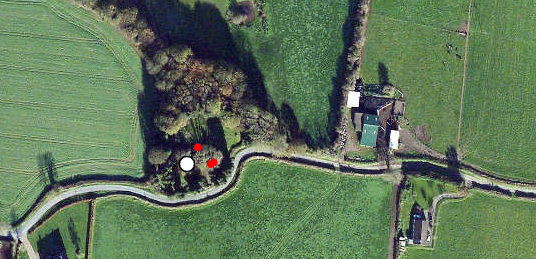
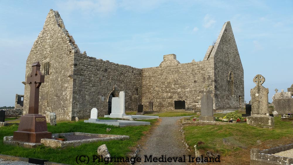
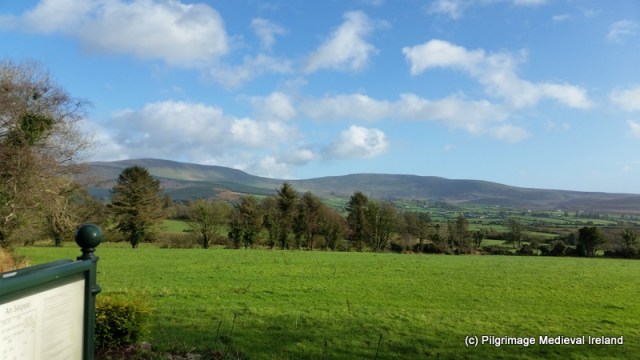
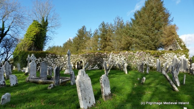
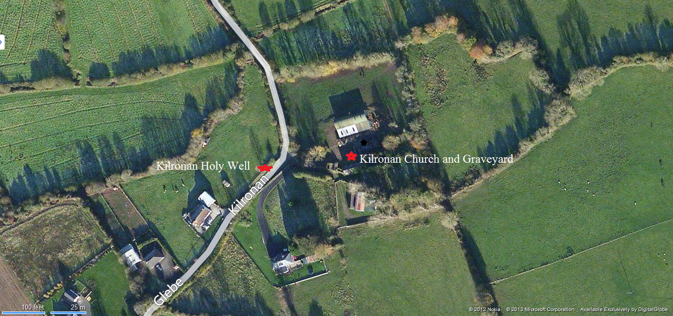
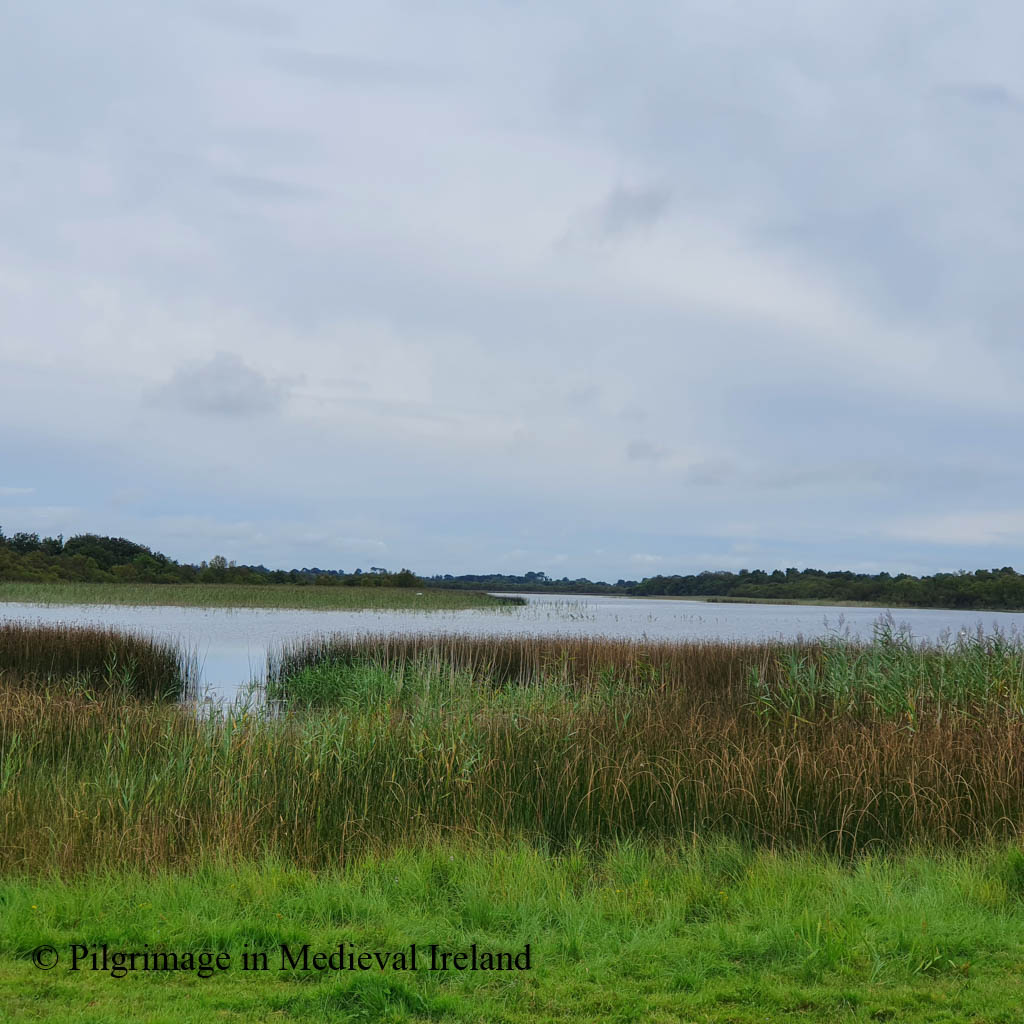
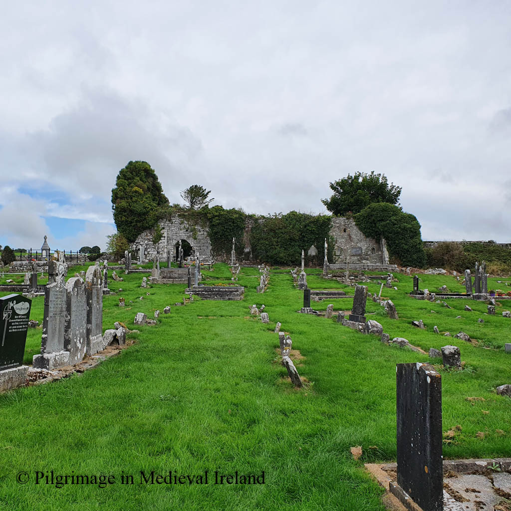
The plague stone is located at the ruins of Fenloe/Tomfinlough church (townland of Finlough/Tuaim Fhionnlocha) and historic graveyard in east Co Clare, n a scenic location overlooking Fenloe lake. Folklore records the lake was once home to a mermaid.

Long ago the mermaid used to be seen in Fenloe Lake and she combing her hair with a golden comb. In summer time. All the people used to see her.

The Schools’ Collection, Volume 0599, Page 244
View of Fenloe Lake

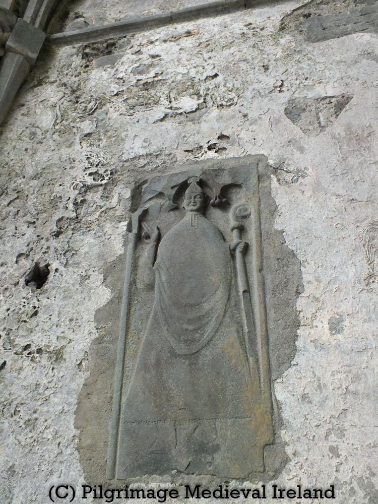
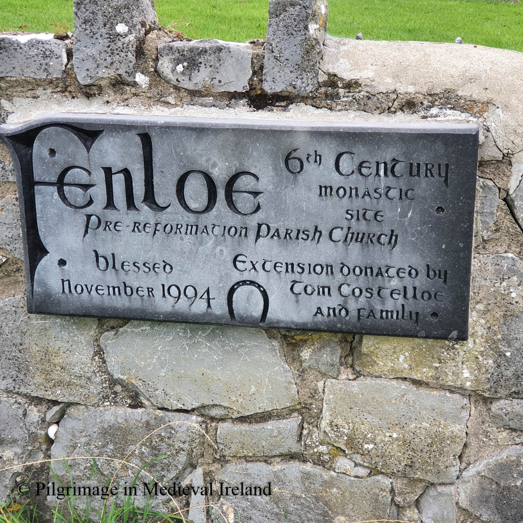
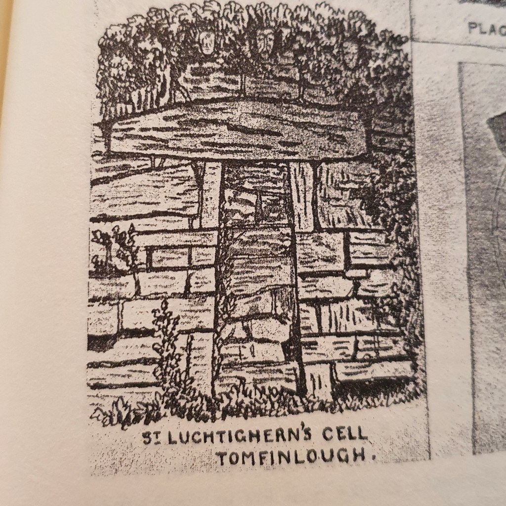
Fenloe church is located at the site of an early medieval monastery which was founded in the sixth century by St. Luchtighern. The Dictionary of Irish Saints tells us the saint belonged to the Tradraighe tribe, whose lands ‘were almost co-extensive with the barony of Bunratty’. The saint’s feast was traditionally commemorated on the 28th April.

Eugene Curry who visited Fenloe in 1839, noted there was no patron saint within the parish but Luchtighern’s memory seems to have been revived at a later date and by the 1930s the saint was mentioned by name in the schools essay.

Modern plaque at Fenloe church

Little is known of the history of the early medieval monastery, except for a handful of entries that are to be found in the Irish annals from the late tenth and eleventh century. For example, the Annals of the Four Masters recorded the death of the abbot of Fenloe monastery in A.D 944:

Scannlan, Abbot of Tuaim-Finnlocha …died

Annals of the Four Masters (https://celt.ucc.ie/published/T100005B/index.html)

Decades later in A.D 1048, the Annals of the Four Masters, recorded the death of another member of the religious community.

Tuathal Ua Muirgheasac, lector of Tuaim-Finnlocha, died.

Annals of the Four Masters https://celt.ucc.ie/published/T100005B/index.html

The church was also attacked by Turlough O’Brien the King of Munster, in the company of the men of Connaught, in A.D 1054.

Toirdhealbhach O’Briain, accompanied by the Connaughtmen, went into Thomond, where he committed great depredations, and slew Aedh, son of Ceinneidigh, and plundered Tuaim-Finnlocha.

Annals of the Four Masters https://celt.ucc.ie/published/T100005B/index.html

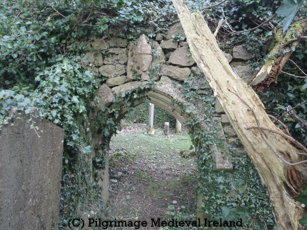
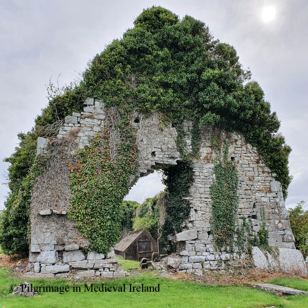
By the twelfth century Tomfinlough had become a parish church. Apart from some masonry in the present church, no trace of the early monastery can be seen above ground today.

The current church is a multi-period building with

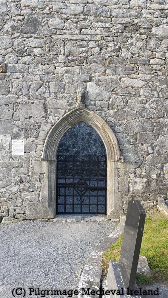
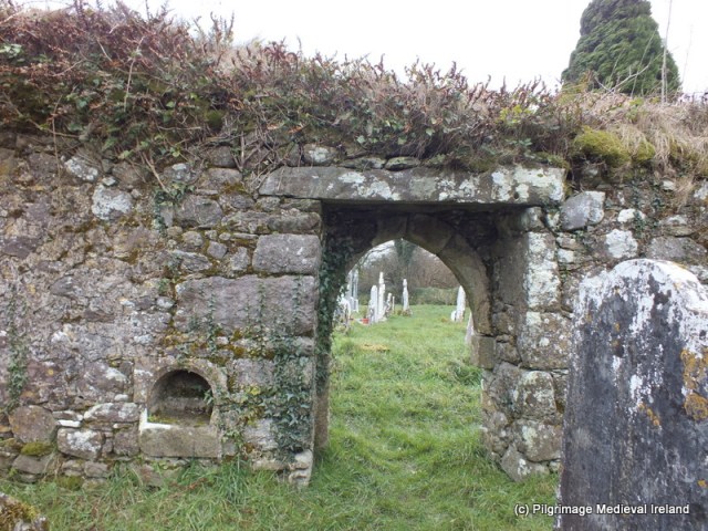
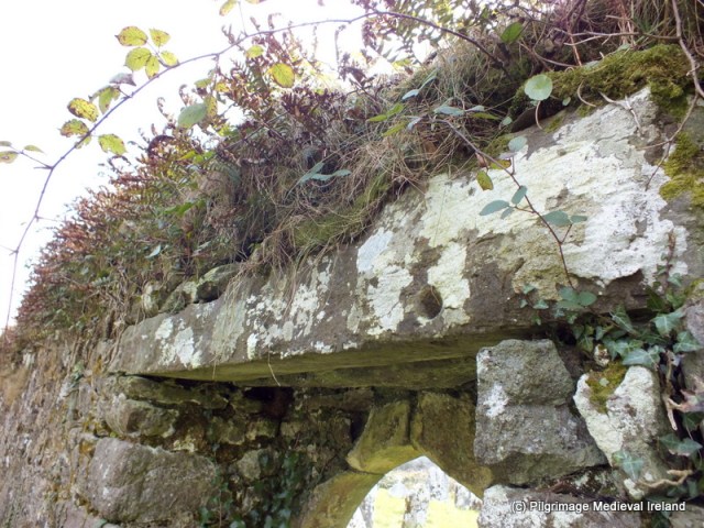
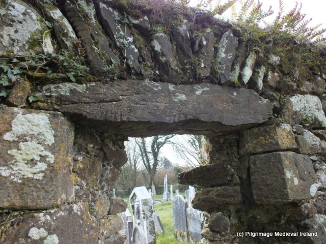
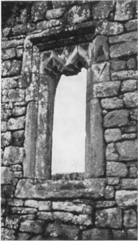
evidence of building and refurbishment over three separate phases. Large blocks of masonry around the door area represent the earliest phase, and may date to between the tenth and the twelfth century. During the Anglo-Norman occupation of this area in the late thirteenth and early fourteenth centuries, the church was restored and some fine cut sandstone windows were inserted into the south wall and east gable….Finally, in the fifteenth century, the triple light east window was blocked up and a double light trefoil-pointed limestone window was inserted. The doorway was also inserted in the fifteenth century. A buttress has been erected against the southeast corner to support the leaning east gable.

Rian na Manach p 49

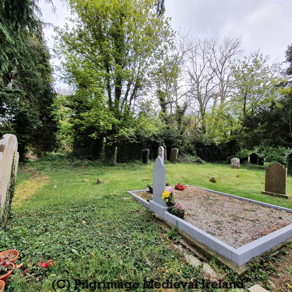
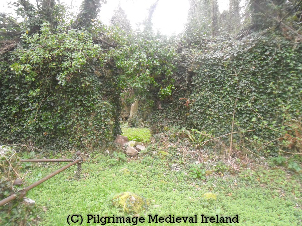
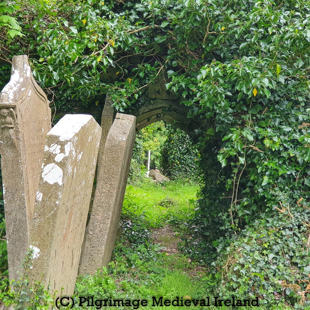
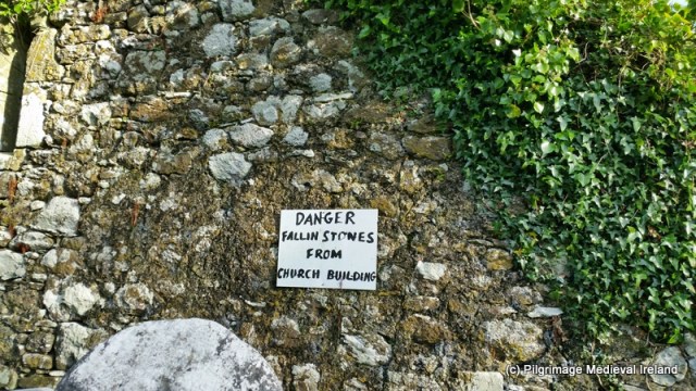
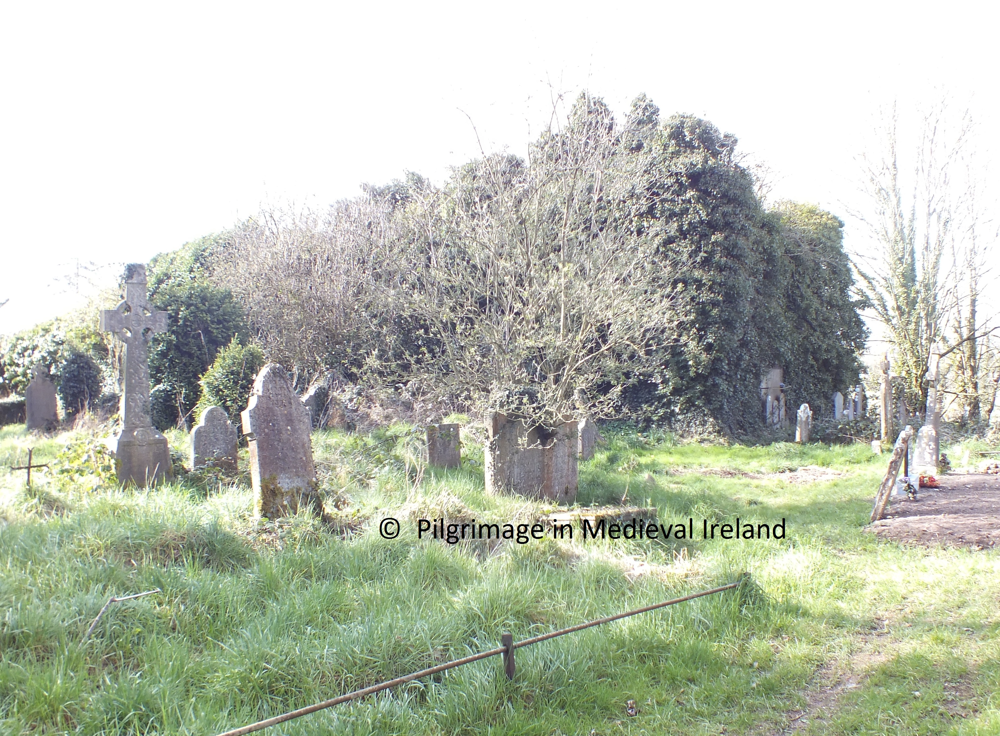
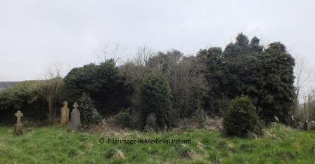
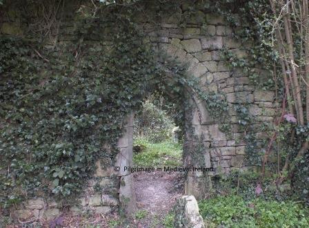
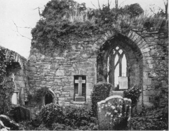
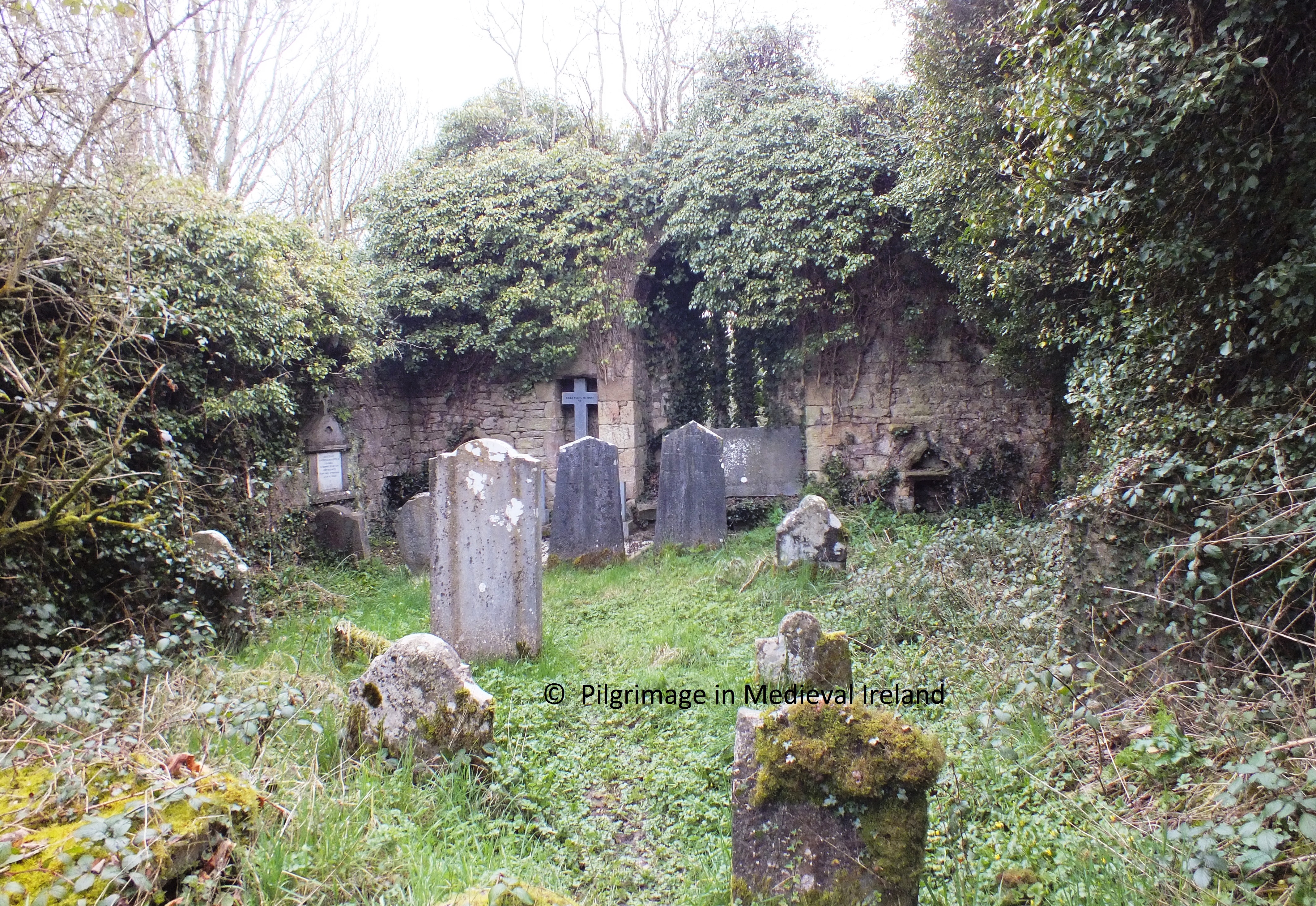
Today the church is in poor conditions. The walls are covered in thick ivy that obscures much of the surviving windows and other features. The north wall of the church fell in 1907 and the east gable was blown down by strong winds in January 2007.

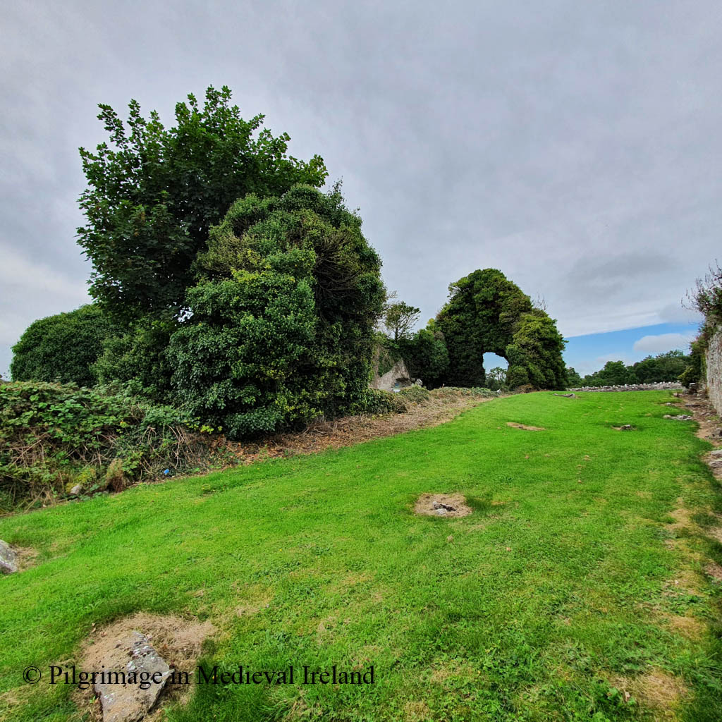
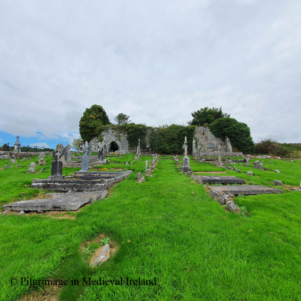
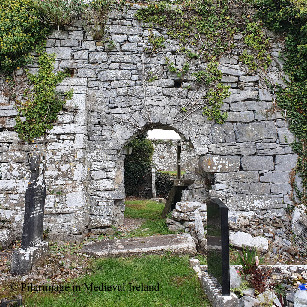
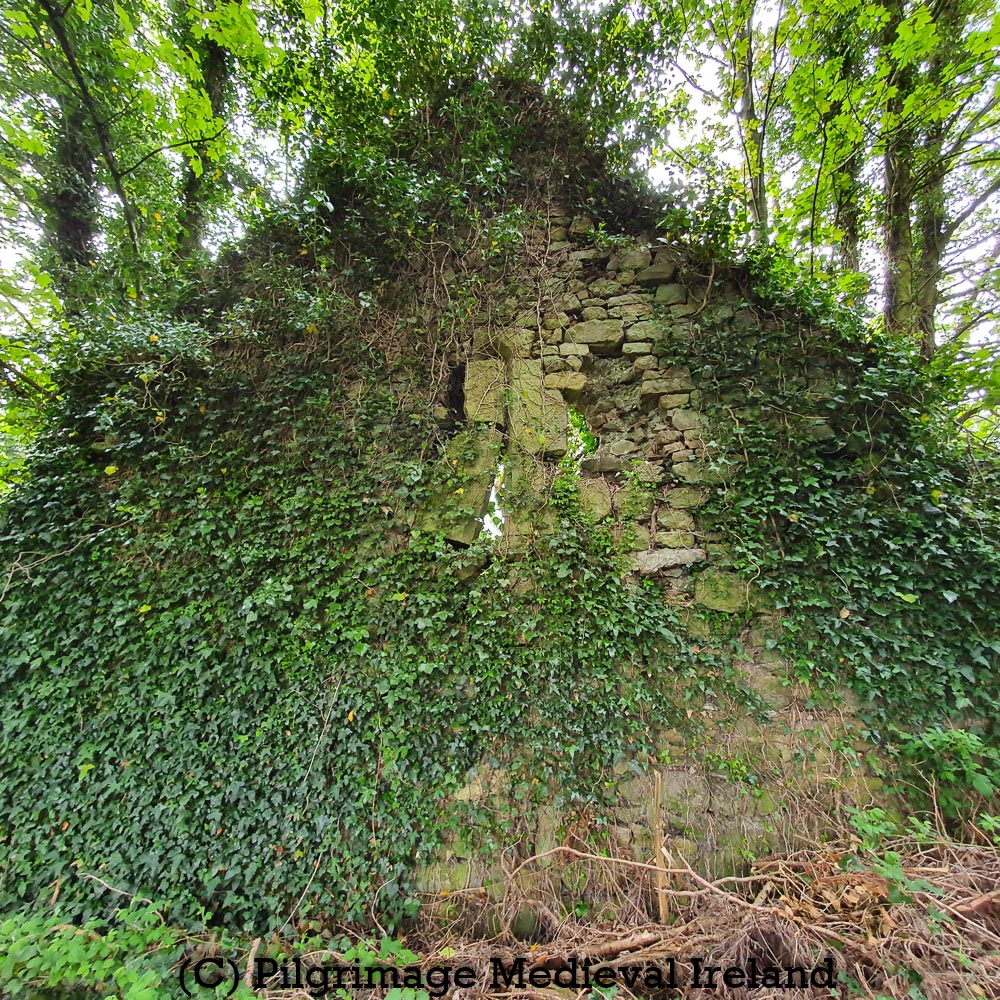
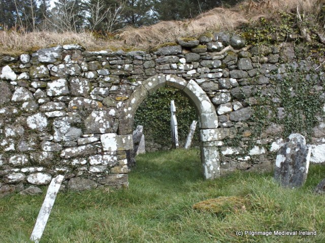
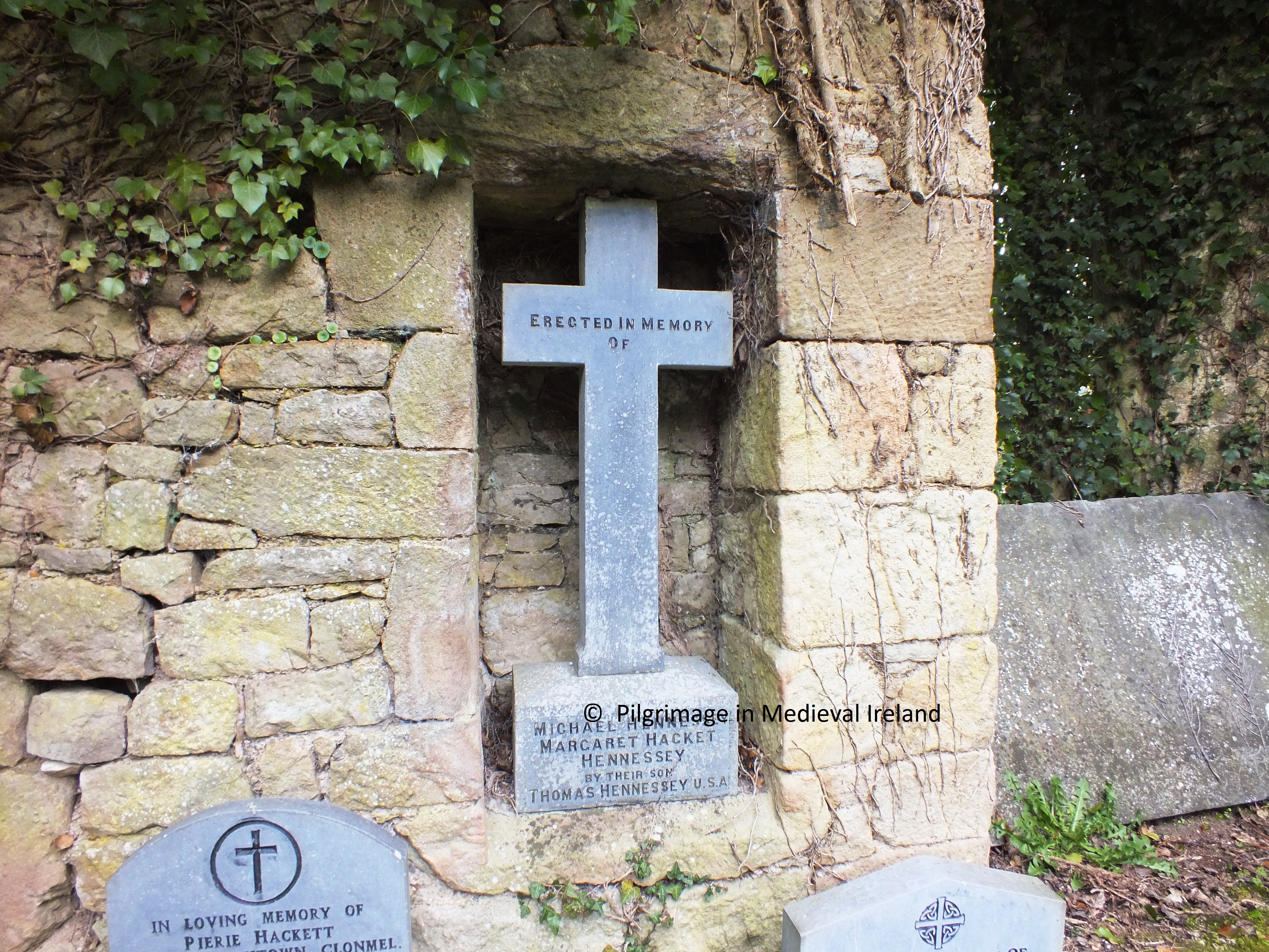
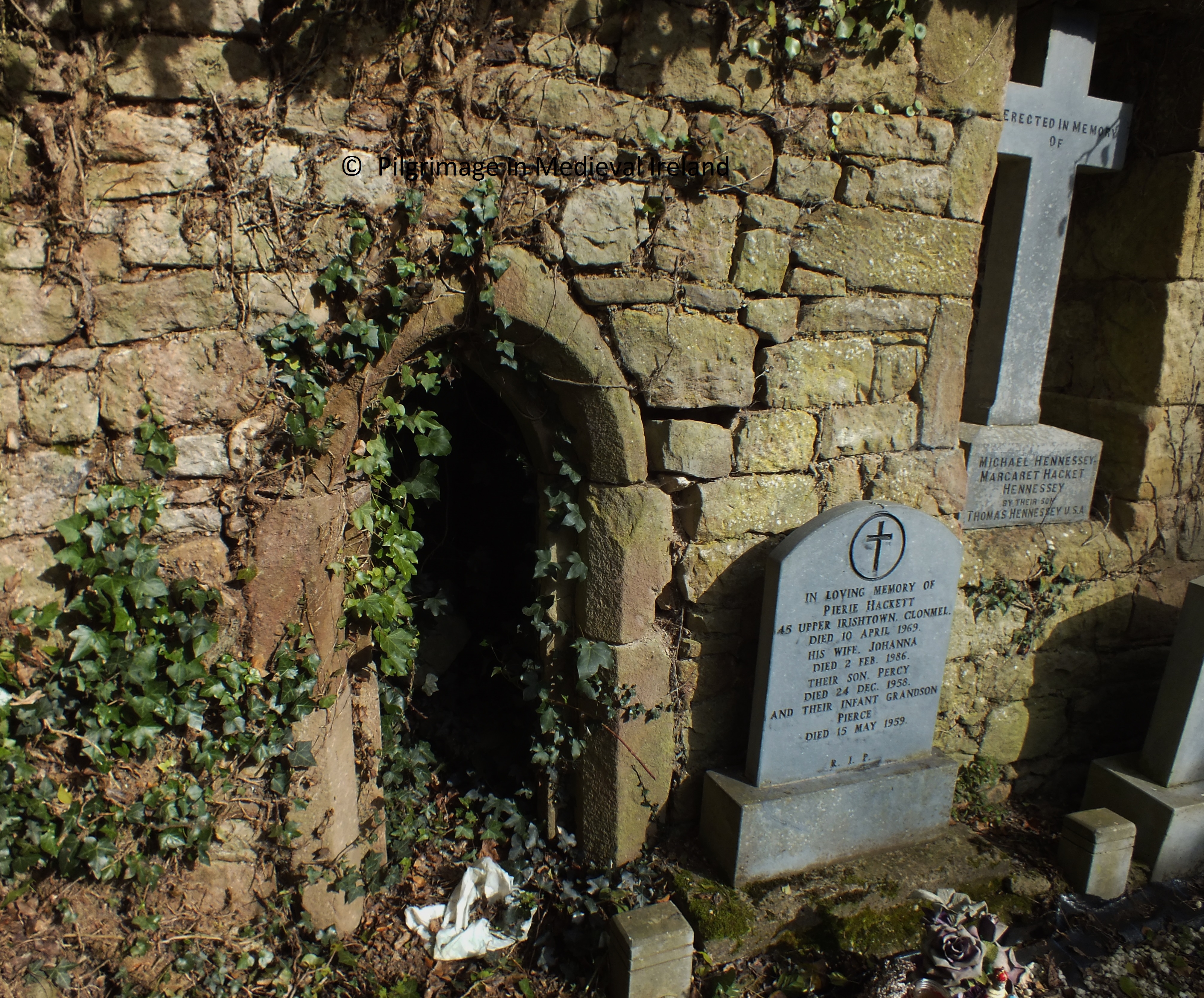
The church is surrounded by a rectangular graveyard. The north and west walls are quite tall and were formerly boundaries to gardens connected with nearby Fenloe house. Curry, when he visited here in 1839 noted the remains of a second church built into the garden wall.

Fenloe church and graveyard

About sixty yards south from the east angle of the Church and included in a kitchen garden wall, is a pieces of a wall nine feet high and twelve feet three inches long, finished at the extremities with large cut stones, like the angles of the gable of a house, and having a quadrangular doorway in the centre measuring four feet ten in height from the present level of the ground, one foot nine and a half inches in breadth at top and two feet two inches at bottom, covered by a lintel stone five feet long and ten inches thick, but what the condition or appearance of this piece of wall may be on the other side I was not able to ascertain as it forms part of the wall of a gentleman’s kitchen garden, to which I could not at the time gain access.

O’Donovan & Curry p 201

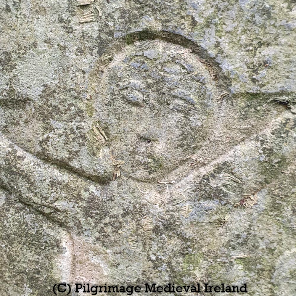
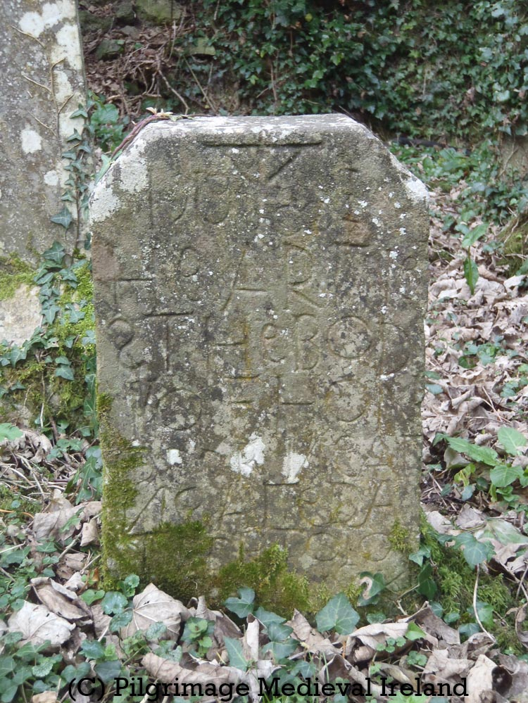
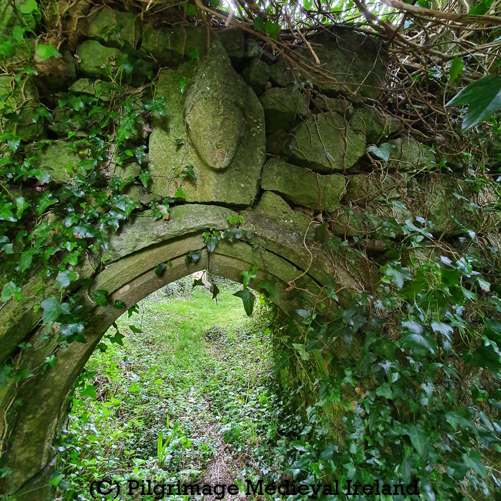
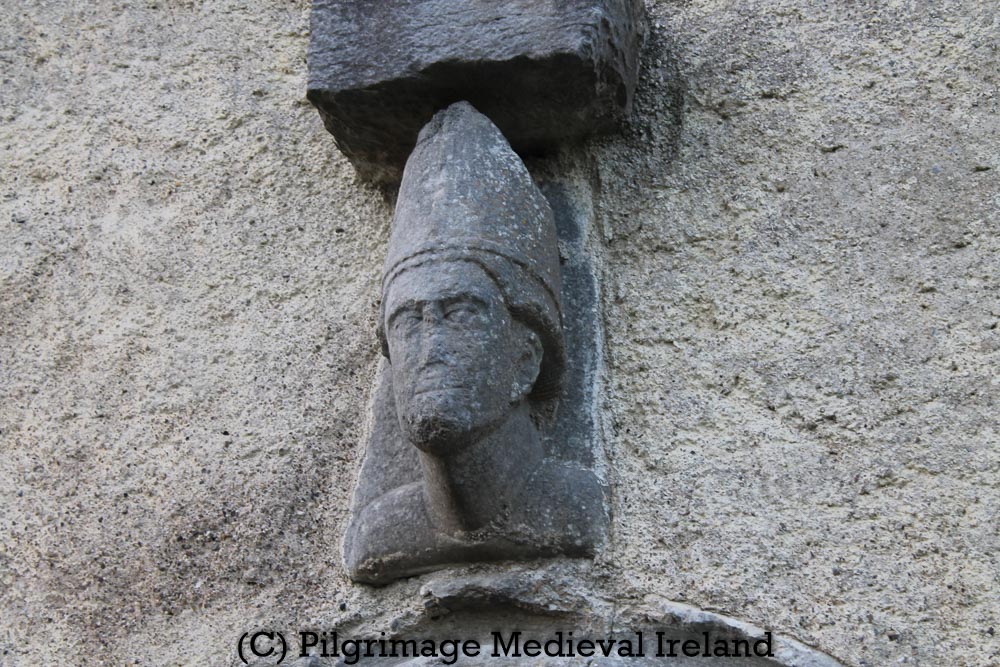
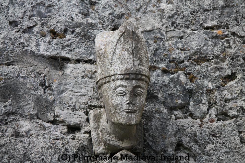
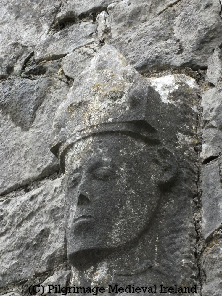
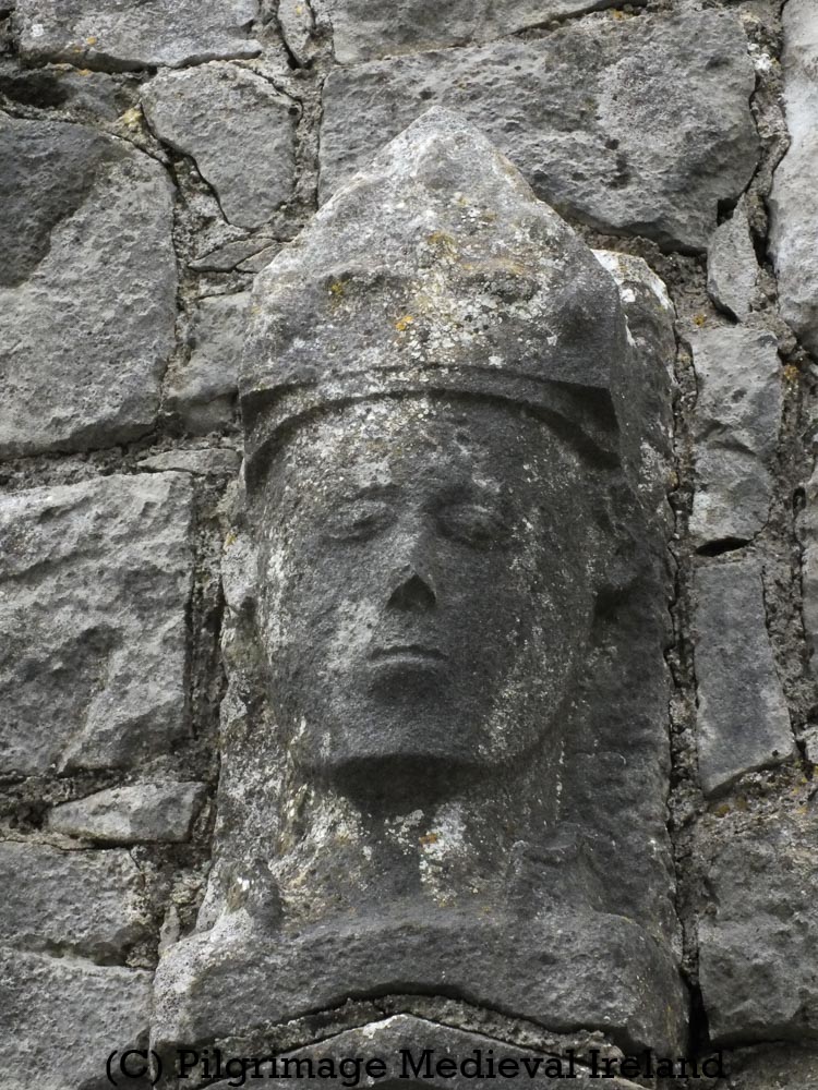
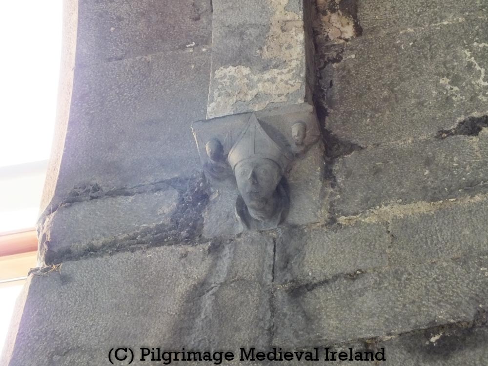
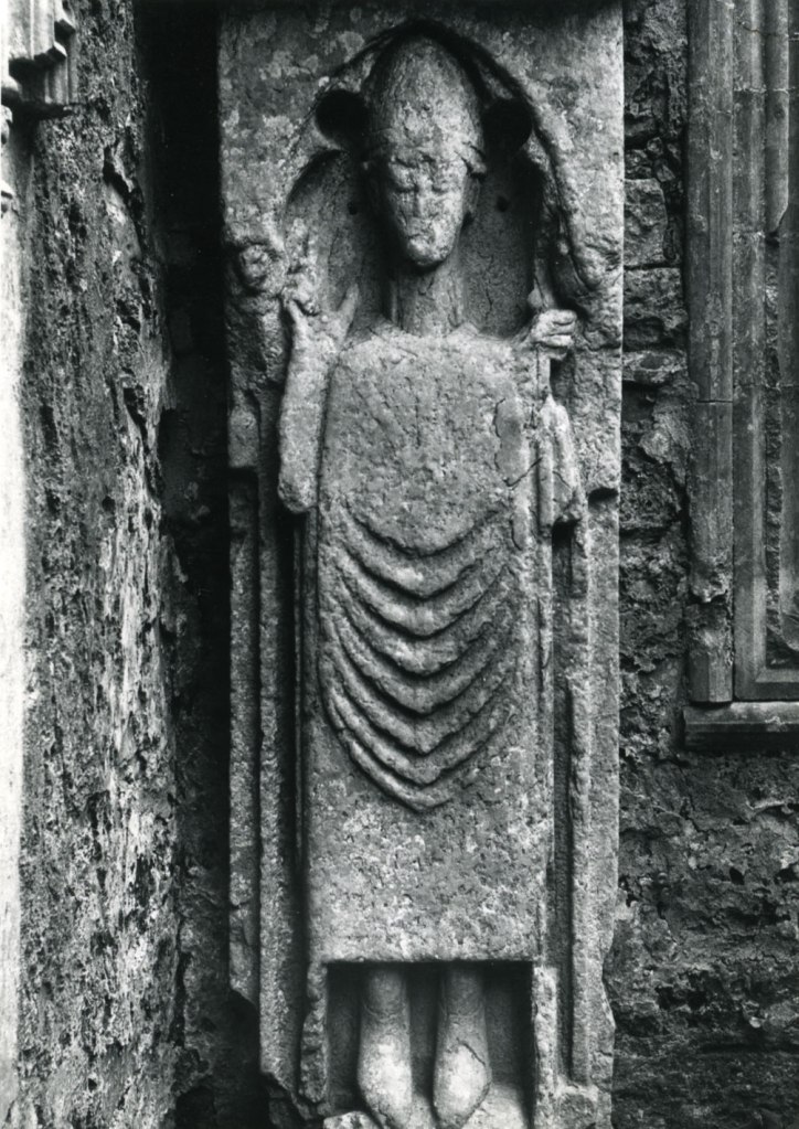
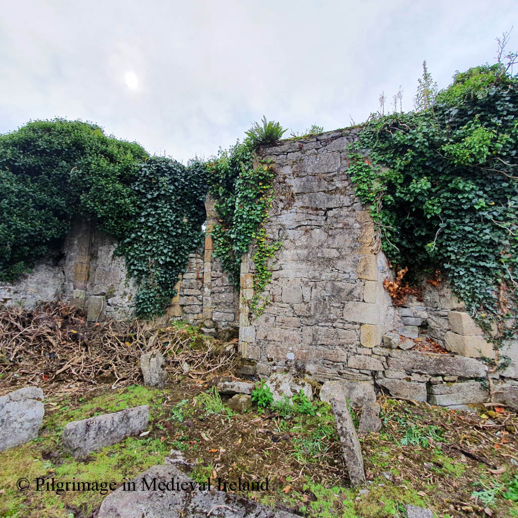
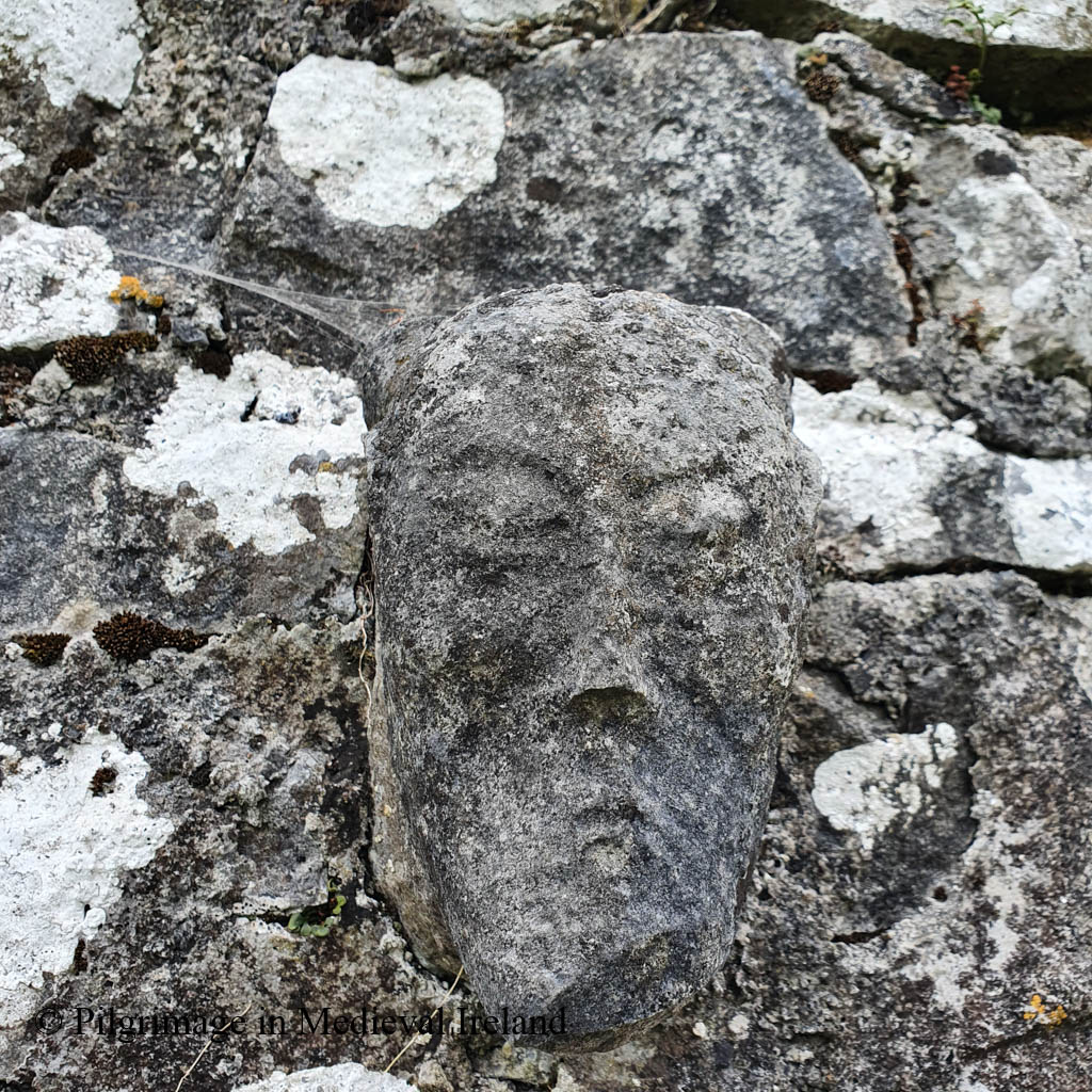
Curry recorded and illustrated three carved head sitting over the lintel in the door described in the wall.

Over the doorway are placed three heads (human), sculptured in stone…

O’Donovan & Curry p 201

Westropp in 1910-13 provides a second account and drawing of the door and heads.

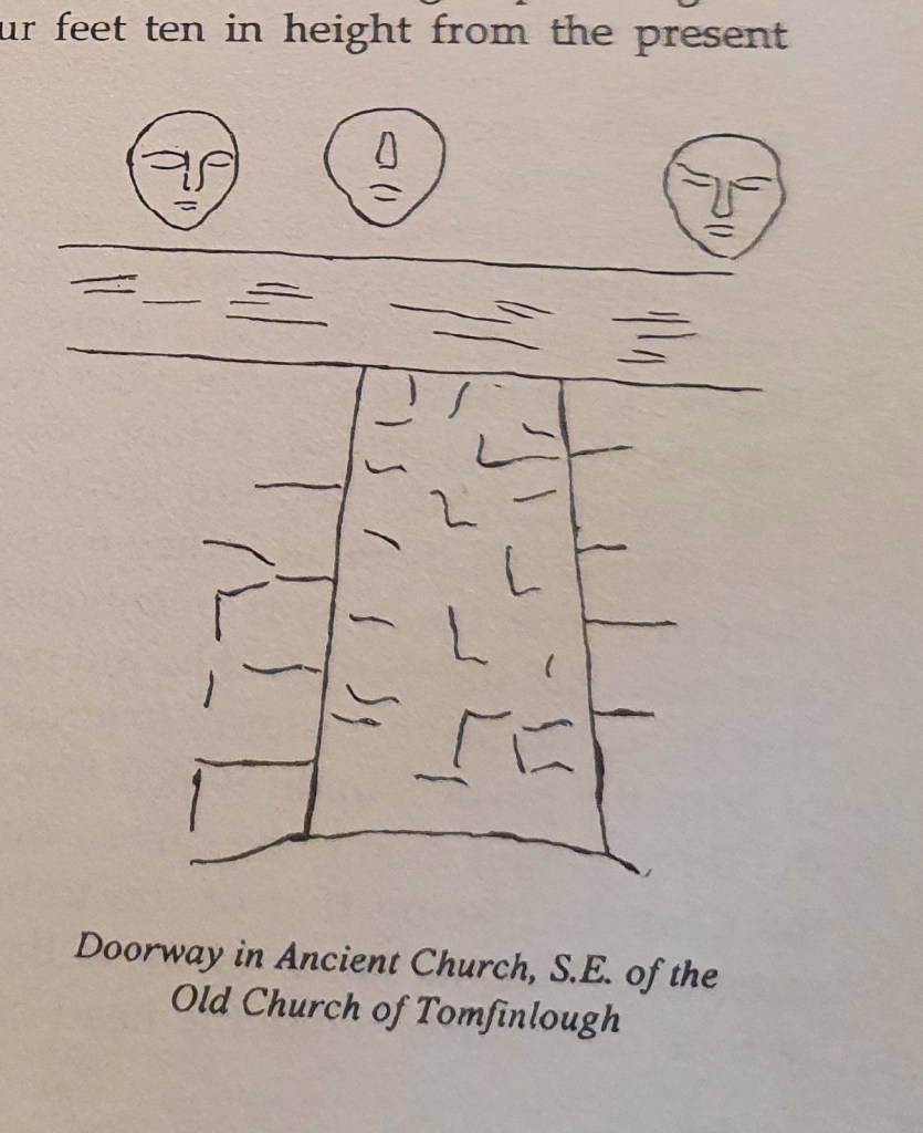
During my visit I didn’t see any further indications of the ancient building. The medieval heads described by Curry are still present but no longer sit over the lintel door, suggesting the wall must have been rebuilt since Westropp’s visit.
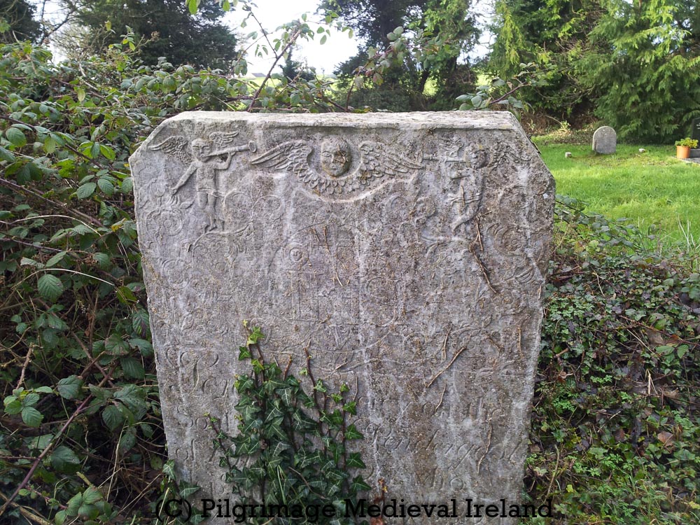
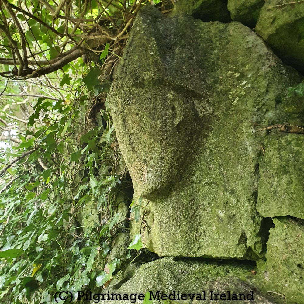
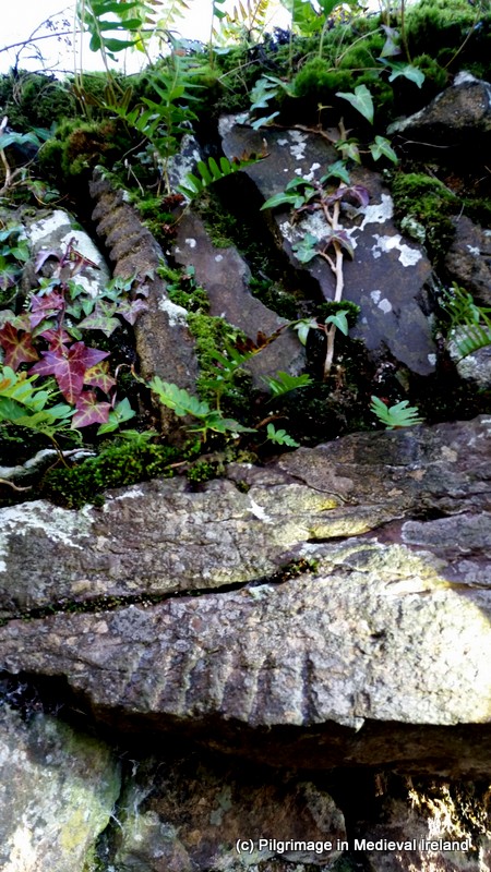
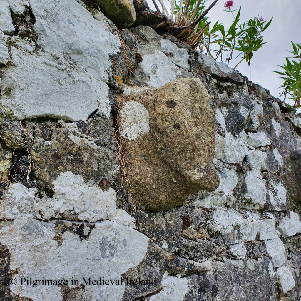
Stone Heads

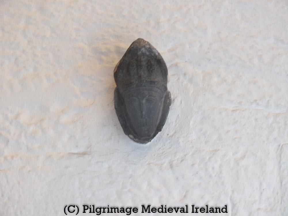
The three carved heads are be found in the south-east corner of the graveyard, built in a line into the upper course of the wall. All three heads are medieval in date. The central head is the best preserved and is carved from limestone; two weathered sandstone heads sit on either side of it.
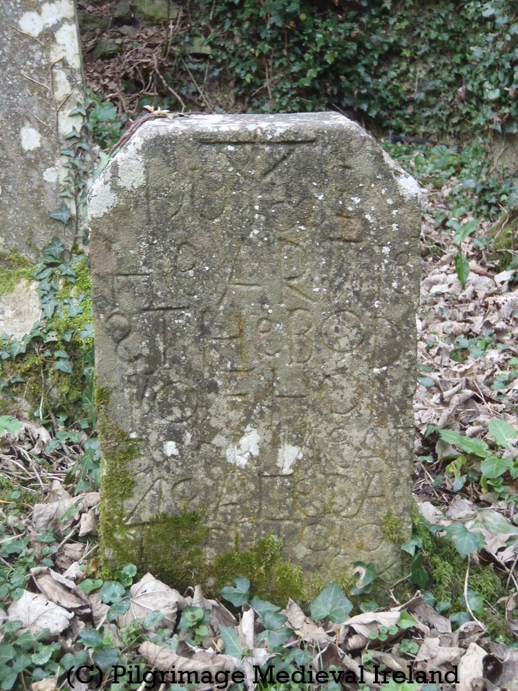
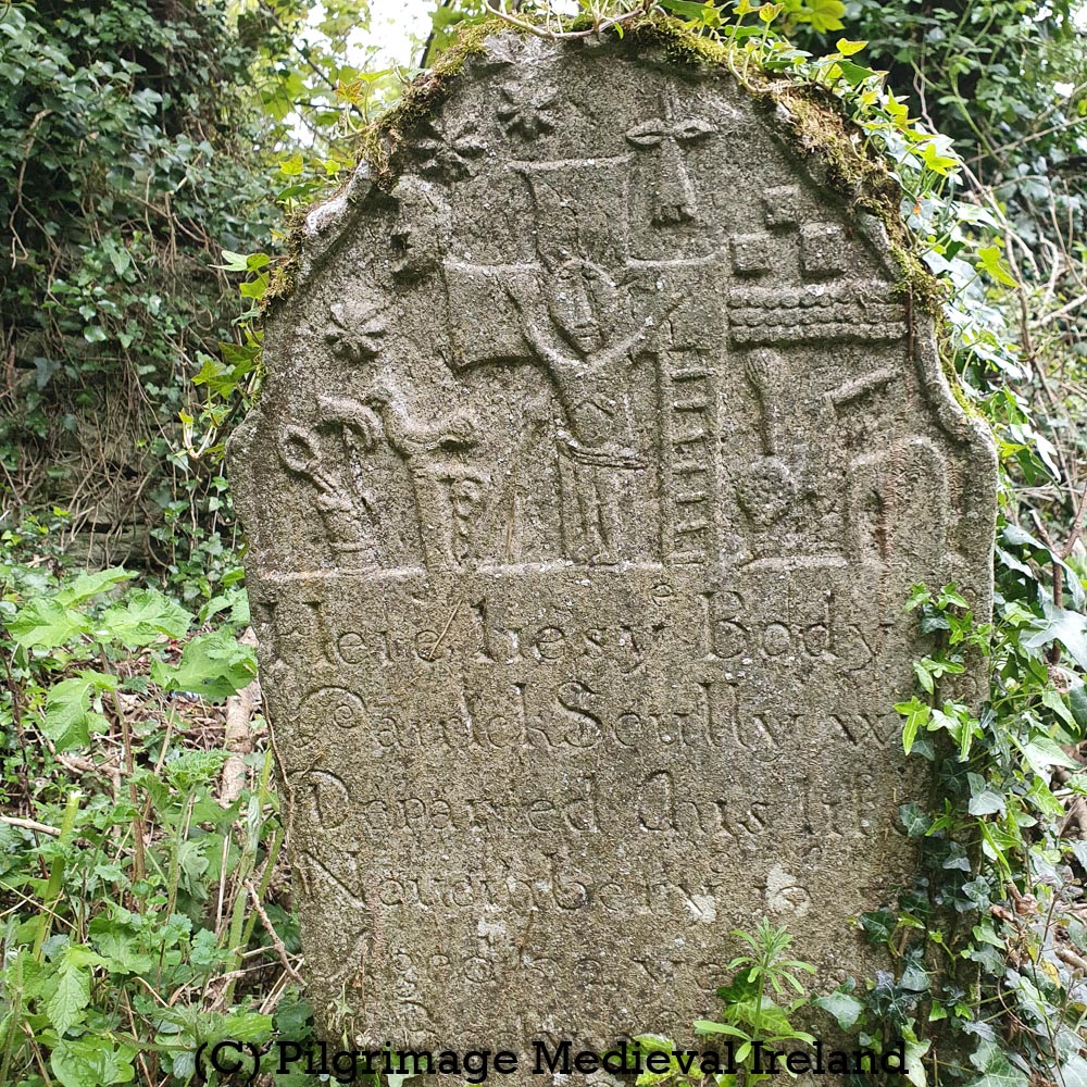
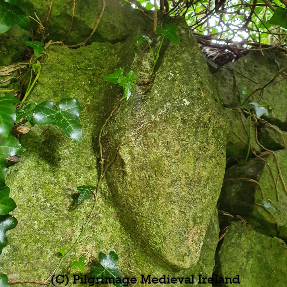
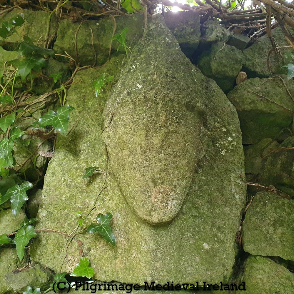
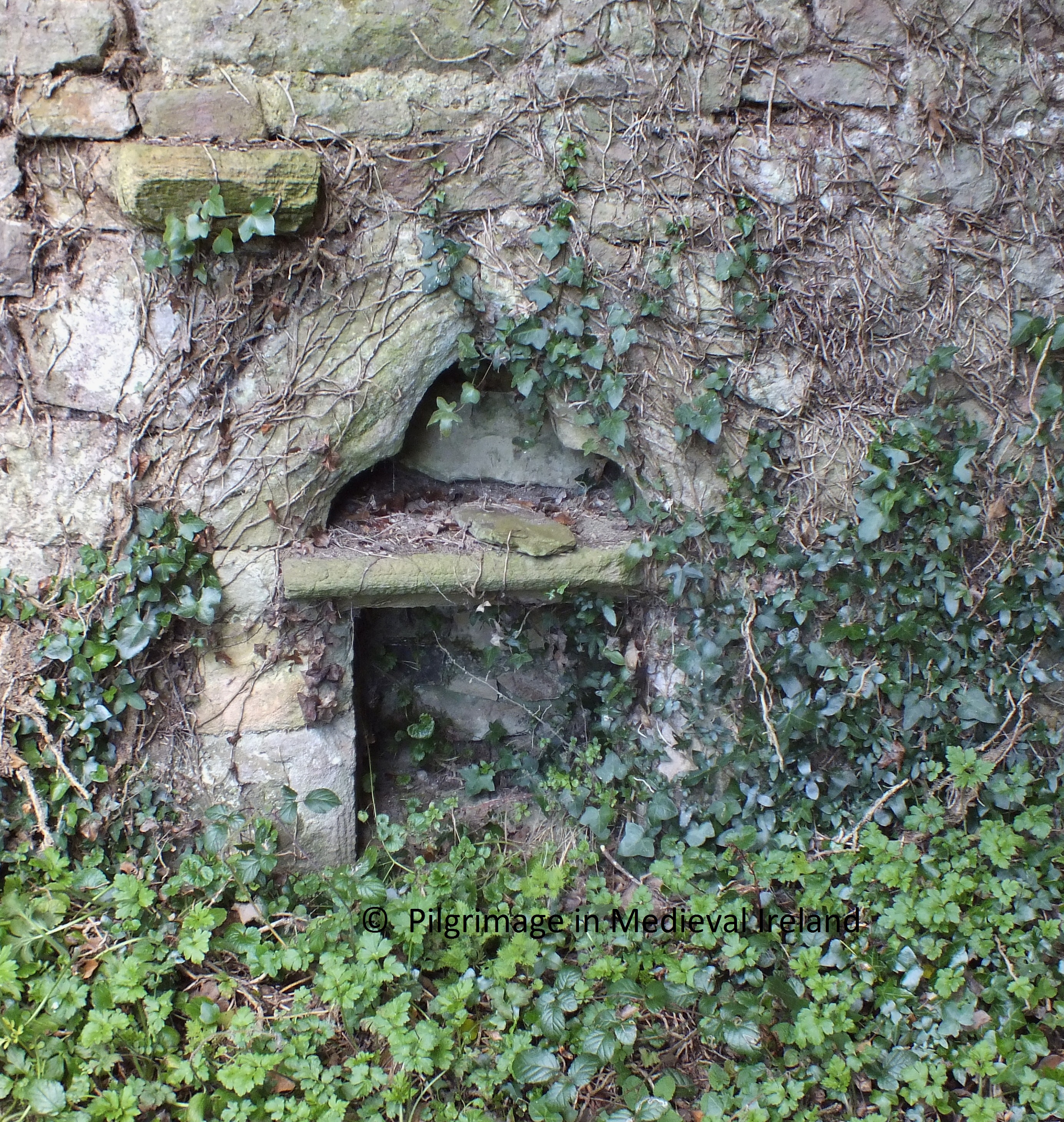
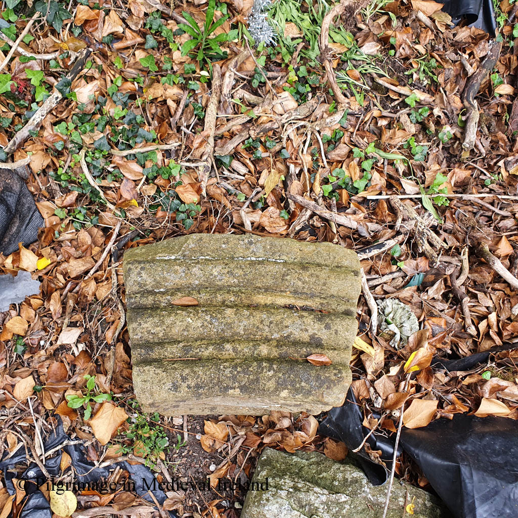
The Plague Stone

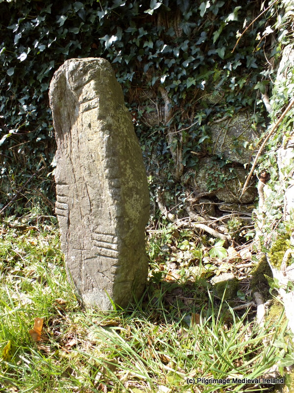
A carved stone as the ‘plague stone’ is located on the exterior of the west wall of the graveyard and is accessed by a stile in the wall. The stile incorporates a coffin rest. Clare historian Michael Houlihan defines these interesting features as follows

These rests are sections of the cemetery wall that are slightly lower than the parapet, with a reasonably wide and level section about a metre in length, fashioned to allow a coffin to rest without disturbance. These remaining rests usually have one or two stiles or stepping stones on either side to allow the bearers to enter with the coffin.

https://heritage.clareheritage.org/places/reading-your-local-landscape/kilkishen-our-local-landscape/coffin-resting-stones-in-clare
Coffin rest in the wall of Fenloe church

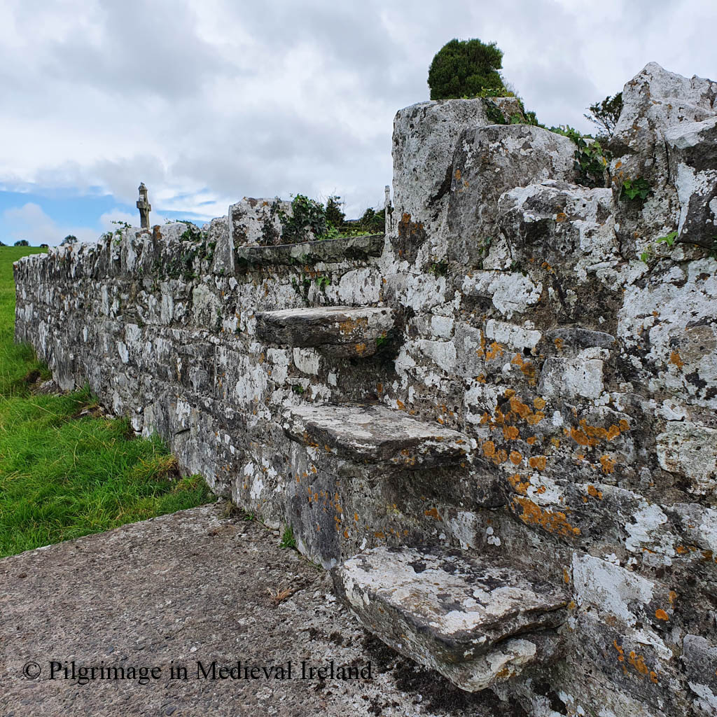
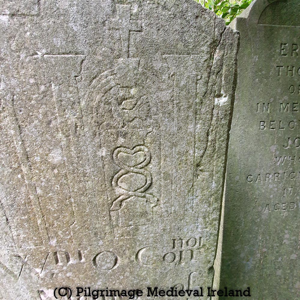
The plague stone is a little difficult to find. When you climb over the stile, head south towards the holy well and the road, and you will see the stone set in the lower course of the graveyard wall. It comprises a large block of stone that is slightly lighter in colour then the rest of the wall. Two circular projections are to be found at the top of the stone: the southern-most example was depicted in the early 1900’s as having a simple Latin cross carved in its centre (Westropp 2003, 93).

Tomfinlough Plague Stone

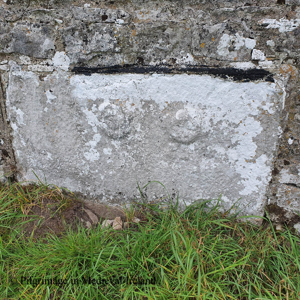
Folklore connected with Fenloe tells of a mysterious plague which was ravaging the country. The abbot of Fenloe cured the first local person who contracted the disease and banished the plague into a large stone, which became known thereafter as the plague stone. Variations of this tale are found in the schools collection and there was a reference to people visiting the stone to obtain healing. The oldest known account of it is to be found in the Ordnance Survey Letters of 1839 outlined below

Long ago a great plague raged all over Ireland and the people were dying in thousands from it every day. It made its appearance in large lumps or boils on the head and no medieval or surgical skill was found to prevail against it. It first broke out in the north of Ireland and soon extended its ravages to the other parts of the Island. When the old Priests of Toomfenlough had heard of its near approach to that part of the Country, he called his flock together, exhorted them to make their souls and requested that the first person in his Parish who should be afflicted with the disease would come to him without a moment’s delay.

In a day or two afterwards as he with two other ecclesiastics of his establishment were making lay in the little meadow near the Church, he had caught the plague and begging of him to come near her. He ran forward the plague then was; she pointed at once to two large lumps and dashed them against the stone, upon which one of them broke and its contents escaped, while the other one remained unbroken. (The broken on is represented on the stone by the figure of the inverted saucer, and the unbroken one by the other figure). The woman was cured immediately of her distemper and after returning many thanks and prayers to the good old Priest set off about her business

O’Donovan & Curry , p203.

The schools essay from Ballycar, Co. Clare note that the stone was visited by people suffering from swollen joints, who would rub the effected limb against the stone making the sign of the Cross.

There are two round prints on the stone. When the people go to visit Fenloe well on the 28th of April, they go to this stone and rub their legs against it three times, blessing themselves at the same time. There was a stone near the well in Fenloe called the Cholera stone and if any person had a sore leg and rubbed it to the stone the person would be cured.

The Schools’ Collection, Volume 0598, Page 463

The school essays for Newmarket records similar healing properties for the stone.

There is a large partly oval stone forming the corner stone of the boundary wall of Fenloe Burial ground Newmarket-on-Fergus Co Clare. There are marks on the stone – one is a misshapen cross, and the shape of a large circle can be traced on the margin of the stone. People that do the pilgrimage to The Blessed Well of St Lutigern quite convenient, never neglect visiting the stone, and rub their legs to the stone making the Sign of the Cross with them whilst doing so. It is said that when St Lutigern lived, the cholera was very brief in Newmarket and surrounding districts. People came to the Saint to be cured. There were so many people afflicted by the disease, and St Lutigern was so occupied ministering to them, that he blessed this large stone and ordered all people afflicted with the cholera to rub their legs to the stone, making the sign of the Cross on it with them, whilst doing so. People possessed of the proper Faith were always effectually cured. At the present day people affected with swollen joints believe that by rubbing them to the stone and making the sign of the Cross with the injured joint that the swelling will disappear. Some people attach a symbolic meaning to the markings on the stone. They say that the circle indicates eternity and that the Cross signifies Salvation.

The Schools’ Collection, Volume 0599, Page 213

The schools essays for Stonehall Co Clare tell a different story.

Here also is a ‘plague-stone’. Sufferers from the Cholera touched this stone and were cured. One day a cholera victim was digging his grave in the churchyard. A stranger came in and questioned him. The man told the stranger he was digging his own grave as he expected to die from the disease. The stranger pounced upon him and removed two pieces of his flesh which he threw against a stone in the wall. He then told the man to touch the stone. He did so and was cured.

The Schools’ Collection, Volume 0599, Page 316-317

Folklore relating to the three medieval stone heads

The medieval heads mentioned above also have a rich folklore connected to them.

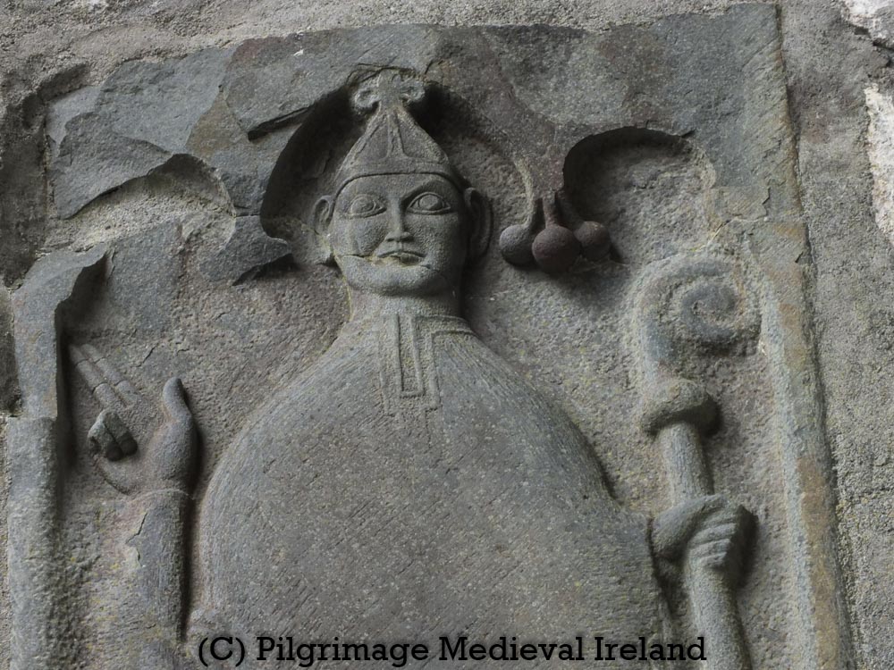
Near the south-east corner of the graveyard there are three stone heads on the boundary wall and their story is connected with that of the plague stone. The story goes that there were three on lookers at the incident of the miraculous cure and one of them was very sceptical. The abbot had three heads carved and mounted over the church door. He placed the head representing the unbeliever in the middle, saying it would gradually yield to the elements while the other two heads would forever remain unaffected by weather

https://www.clarelibrary.ie/eolas/coclare/places/nof_history.htm

Another story from the schools essays from Ballycar

There is a story told about the images of three priests which are to be seen on the boundary wall opposite to that of the cholera stone. The three images are side by side. he centre image represents a martyr of the faith. The image on the right is a repentant martyr and the other one is a traitor which is effaced.

The Schools’ Collection, Volume 0599, Page 294-295
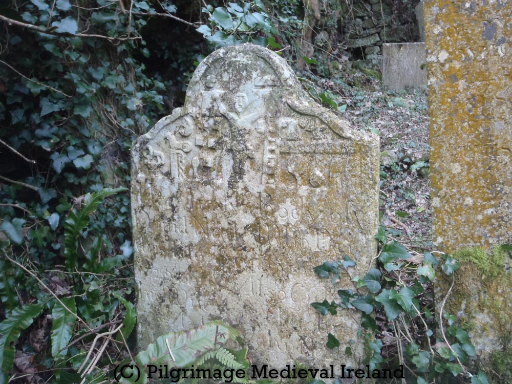
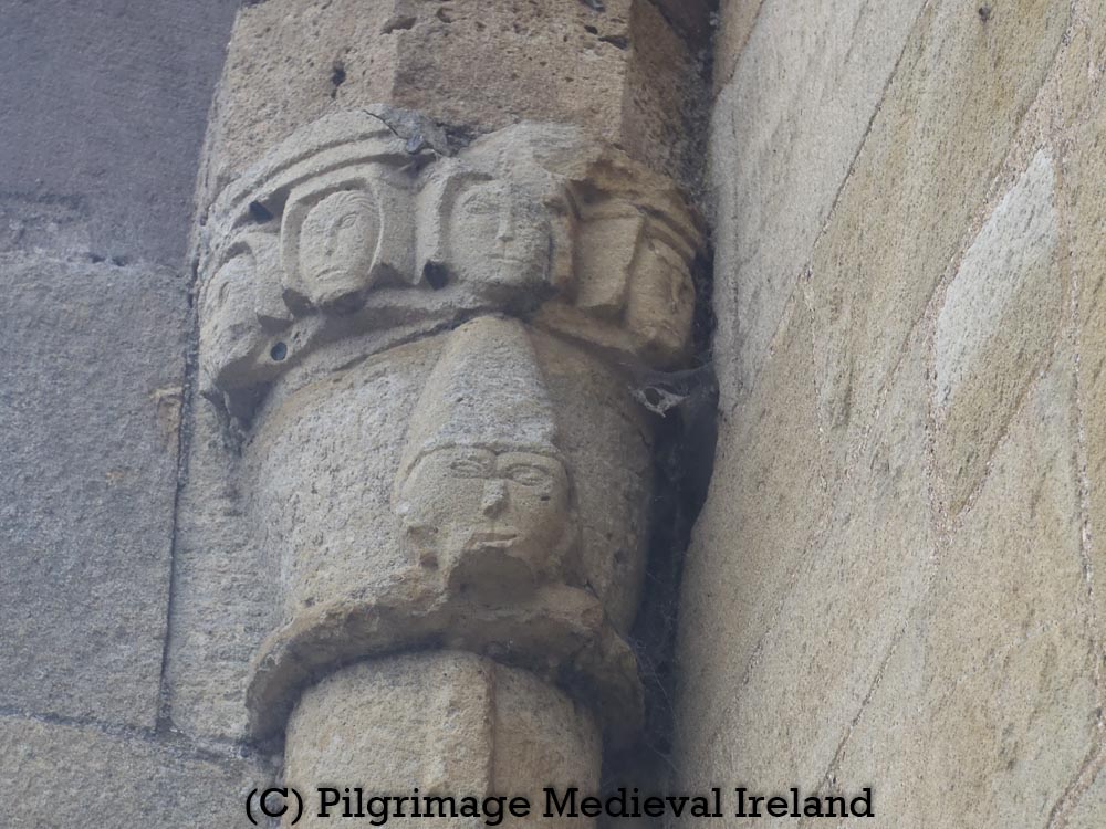
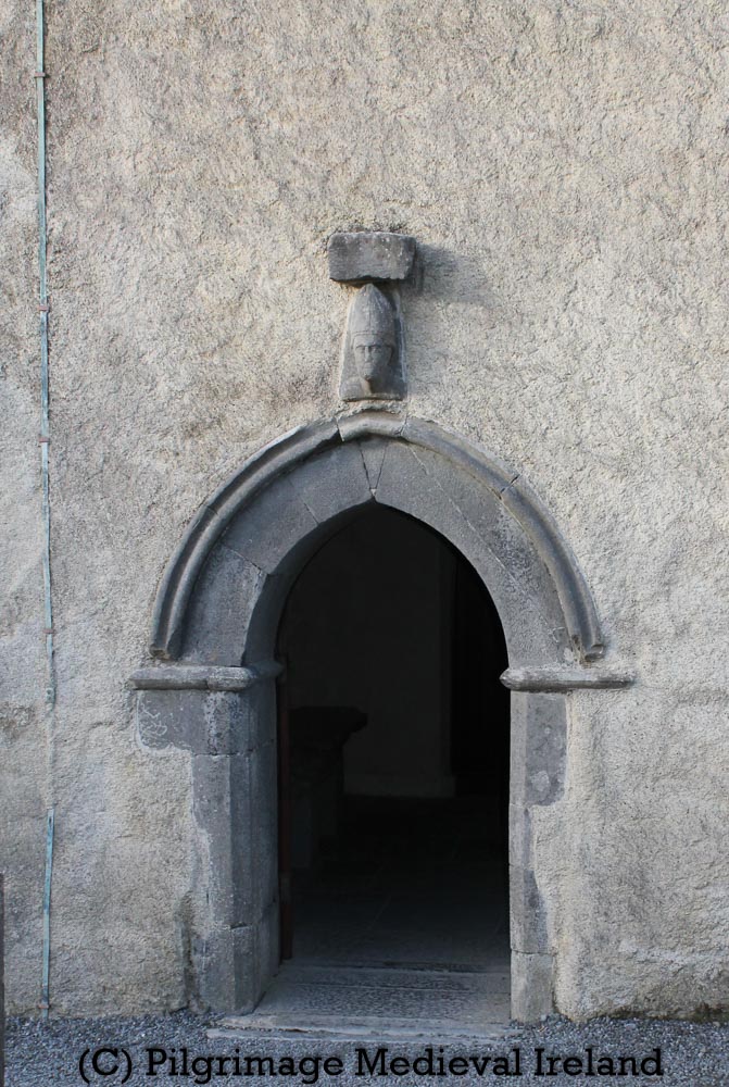
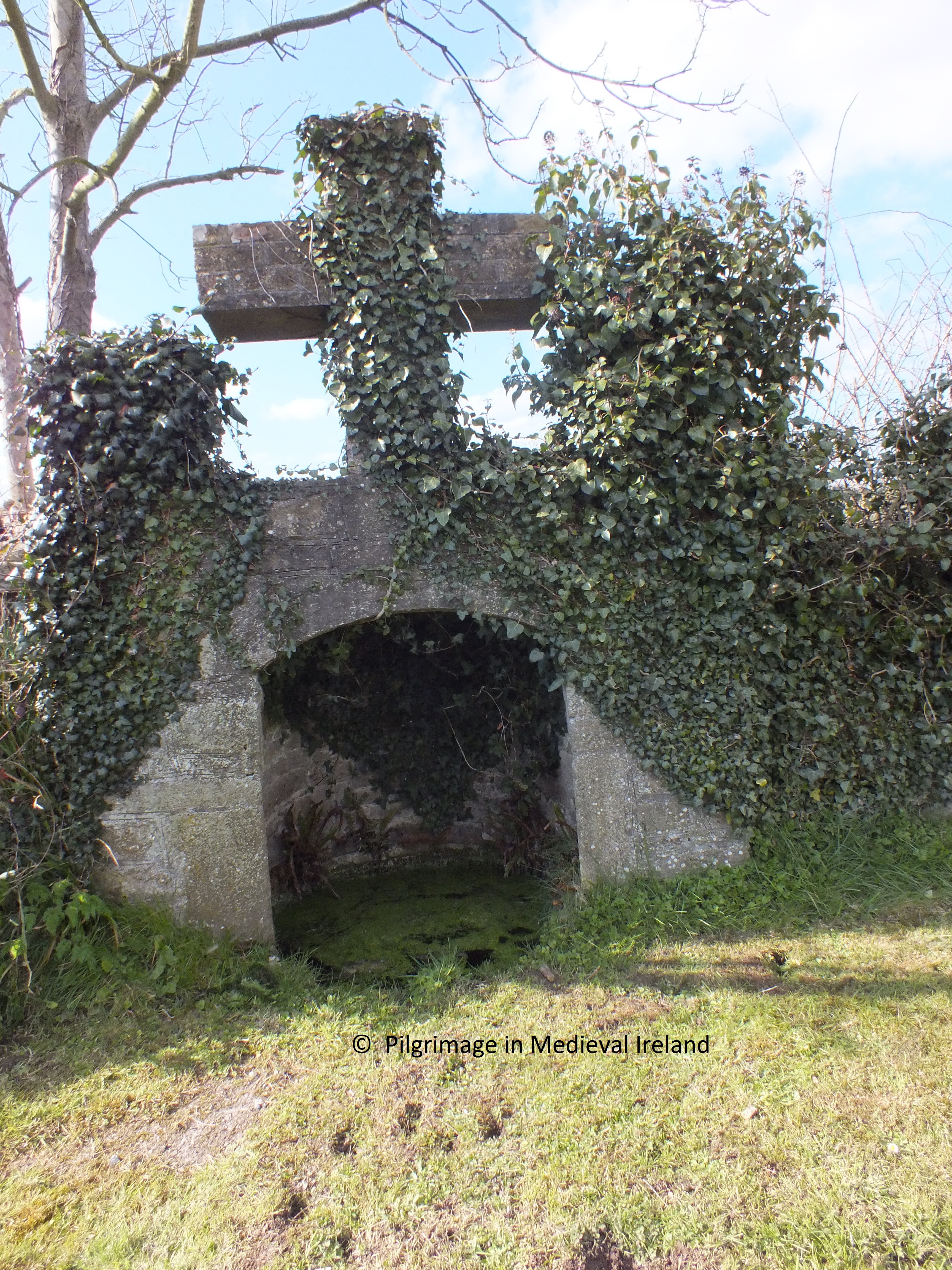
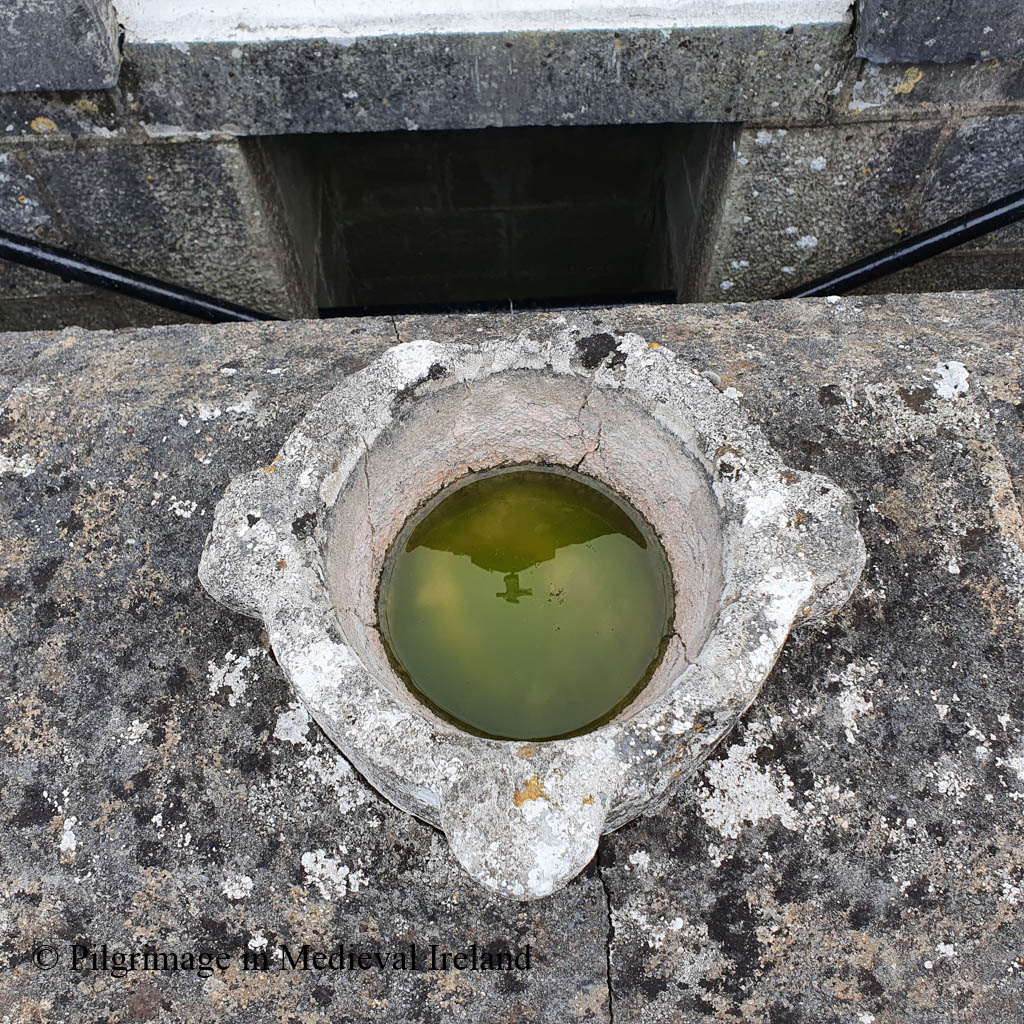
Fenloe holy well

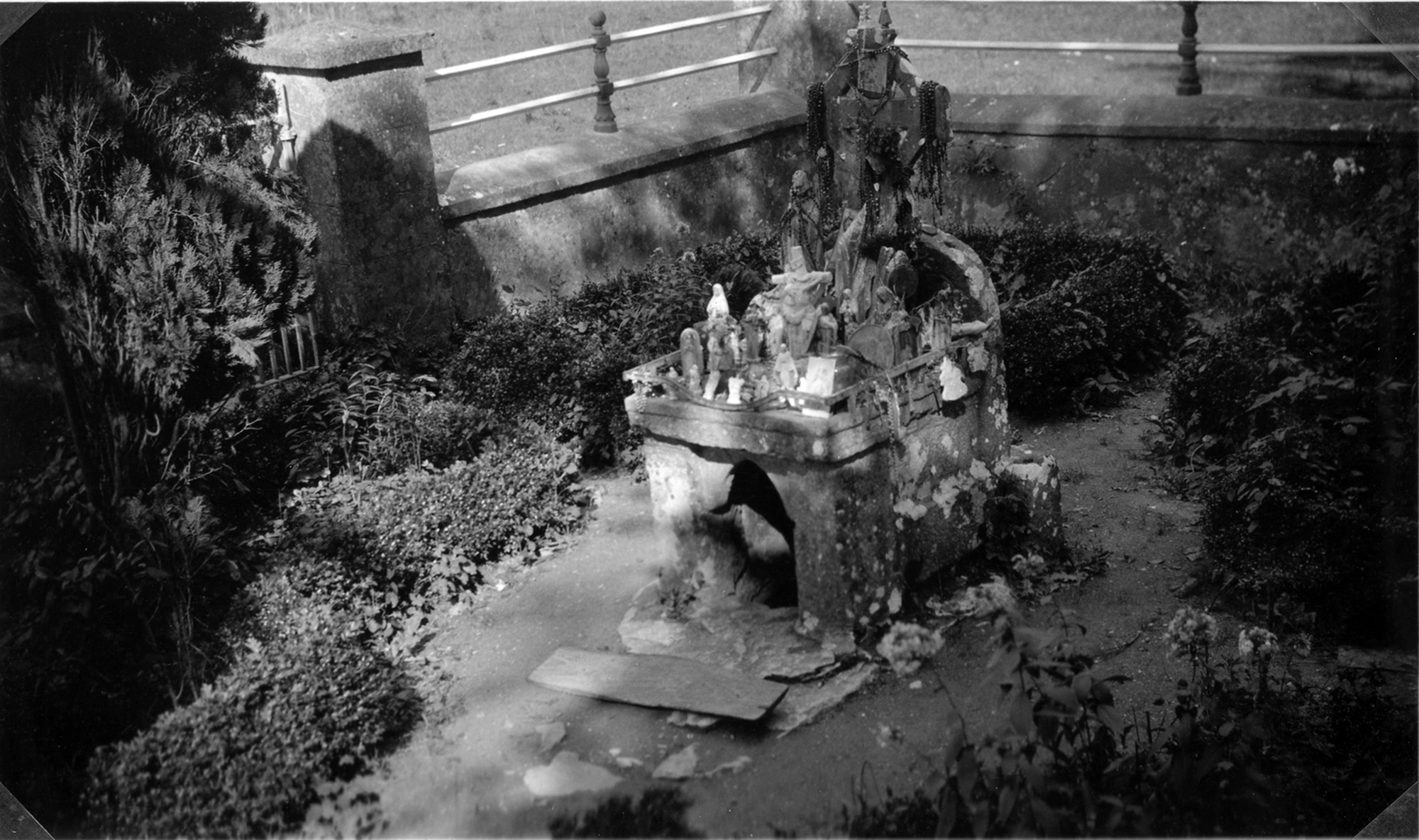
Another interesting feature at the site is a holy well at the roadside near the edge of the graveyard. The well sits within a small rectangular area enclosed by a low stone wall and it is covered by well-house which incorporate statue niche and gravestone. A series of steps lead down to a water-filled rectangular recess.

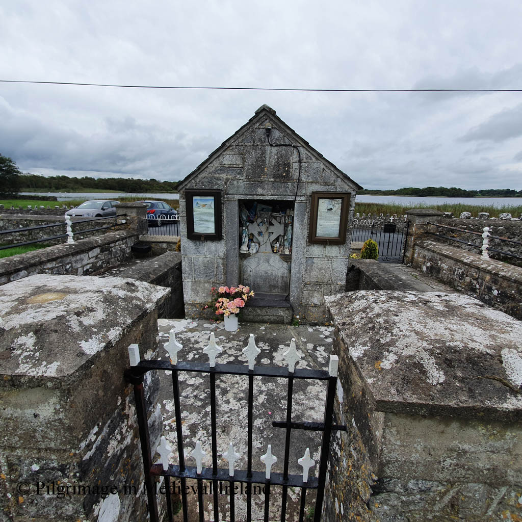
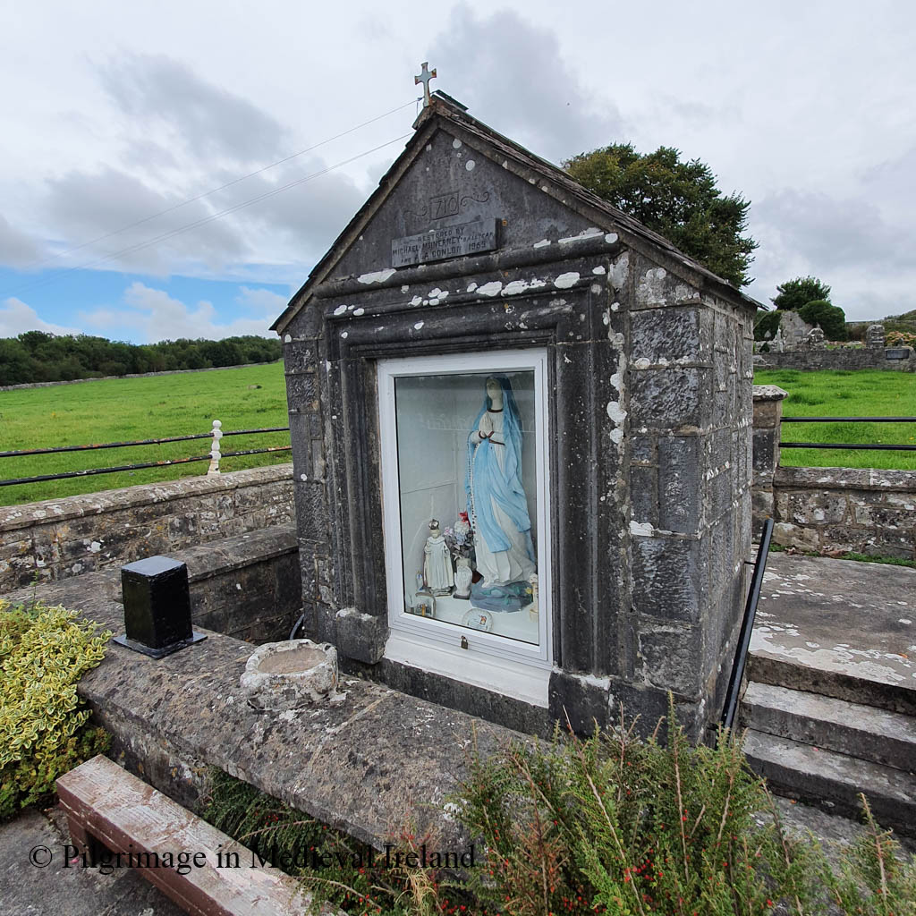
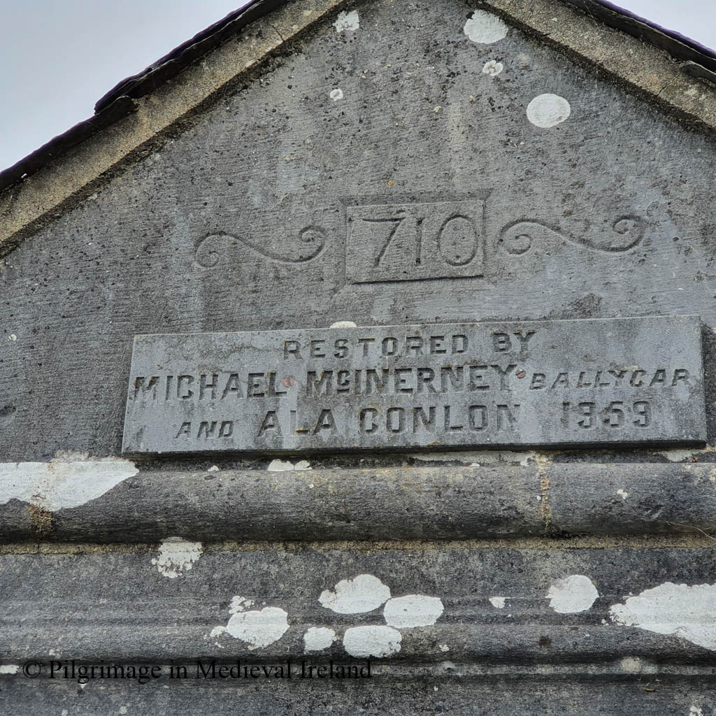
The well house was restored and rebuilt in 1959 by Michael McInerney and Ala Conlon.

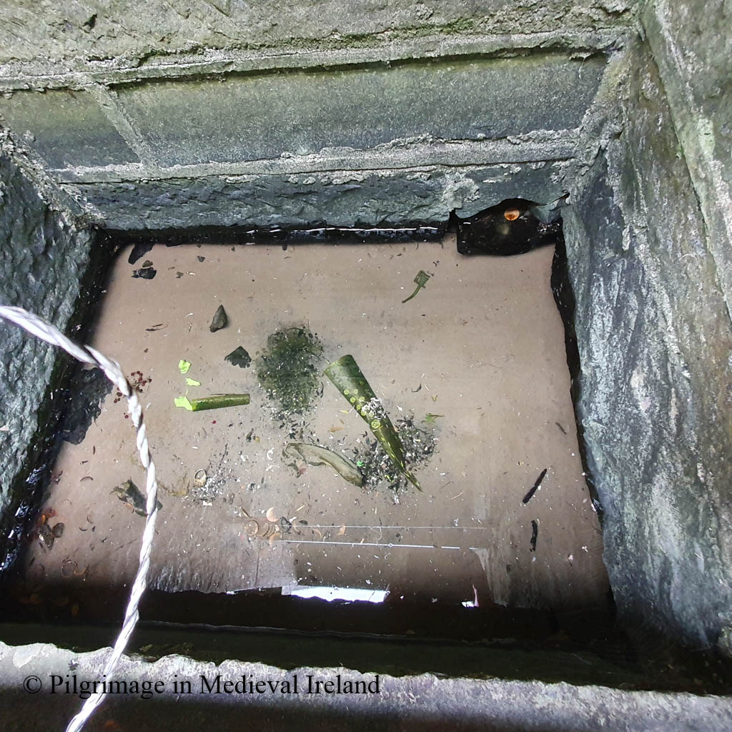
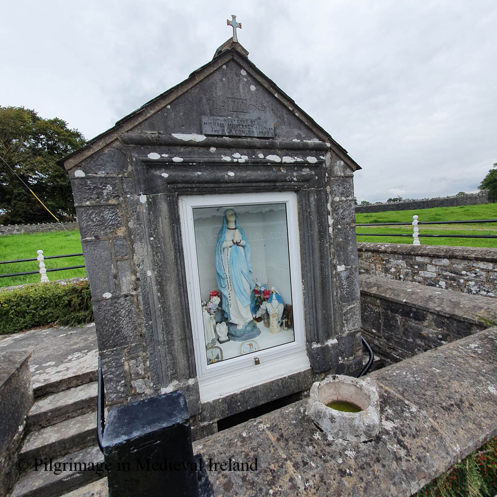
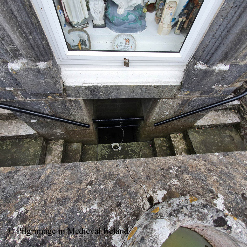
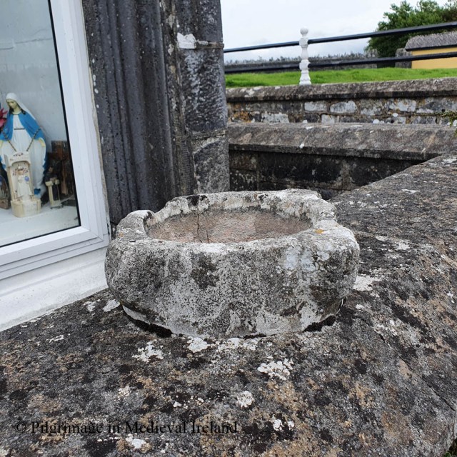
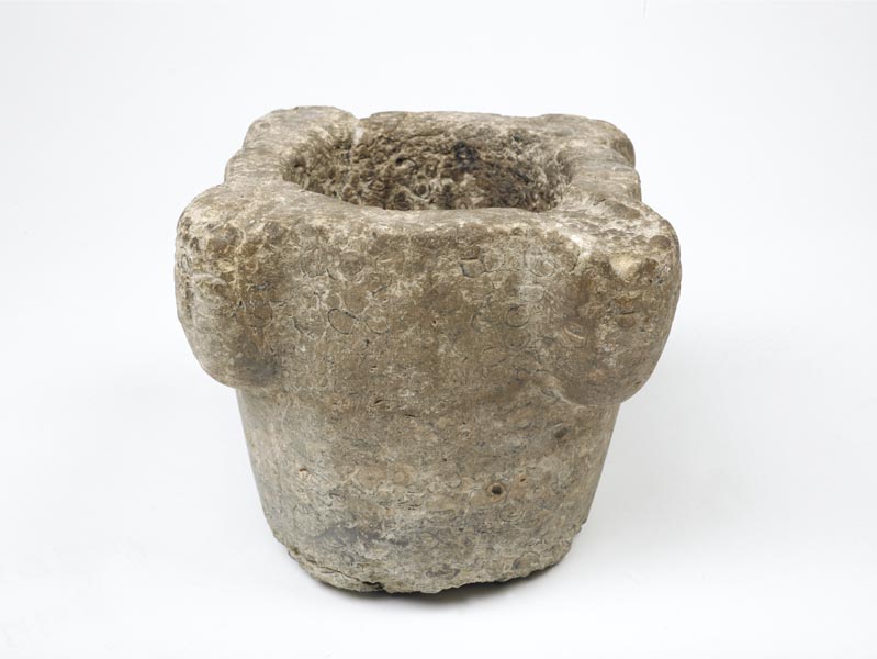
A medieval stone mortar, which has been incorrectly described as a bullaun stone, sits on the wall above the well. recess. Mortars were used with a pestle for grinding food and herbs for cooking or medicines. A similar mortar dated to the 13th century is part of Museum of London catalogue.

Rounds were performed at the well in the 1930s on St Luchtigern’s feast day and offerings left at the well to this day show it is still visited by pilgrims.

pilgrimage is made on April 28th. Five decades of the Rosary are recited. Pictures, medals, crucifixes are left at the shrine, and rags and pieces of cord [?] are attached to a bush nearby. The Schools’ Collection, Volume 0599, Page 316

The waters from St Luchtigern’s well was said to have curative power and was especially favoured for a cure for sore eyes (The Schools’ Collection, Volume 0598, Page 463)

The school essays Newmarket on Fergus, Co. Clare, provide insight into devotional rituals in at the well in the 1930s

They say the Rosary there. They also drink some of the water and rub it to the diseased part. They bring some of it home but they do not use it for ordinary household purposes.

The Schools’ Collection, Volume 0598, Page 464

Reference

Harbison , P. Rian na Manach. A guided tour of the ecclesiastical treasures in Co Clare. https://www.clarecoco.ie/services/planning/publications/heritageconservation/rian-na-manach-clare-ecclesiastical-trail-2006-8938.pdf

Houlihan, M. 2015. The holy wells of County Clare. Walsh Colour Print, Castleisland, Ireland.

O’Donavan, J & Curry, E. 2003(reprint). The Antiquities of County Clare. Ennis: (Clare Local Studies Project ) Clasp Press.

Westropp, T. J. 2003(reprint). Folklore of Clare. Ennis: (Clare Local Studies Project) Clasp Press

The Schools’ Collection, https://www.duchas.ie/en/cbes

Archival Reference The school of Newmarket.The Photographic Collection, F025.19.00225

https://www.clarelibrary.ie/eolas/coclare/places/nof_history.htm

http://newmarketonferguscommunityhall.ie/articles/fenloe.html

http://newmarketonferguscommunityhall.ie/articles/fenloe.html

https://www.logainm.ie/en/6506

https://collections.museumoflondon.org.uk/online/object/35614.html

https://www.clarelibrary.ie/eolas/coclare/archaeology/ryan/part3_chapter32_tomfinlough.htm

The bishop over the door. A medieval carving at Tullaghmelan Medieval Parish Church Co Tipperary

The medieval parish church and graveyard at Tullaghmelan is one of my favorite places to visit in south Tipperary. The name Tullaghmelan means the hillock of Maolán. Tradition holds that Maolán was a saint who had founded a church here in the early medieval period.

There is no visible early medieval features sat the site although a pronounced curve in the road that borders the graveyard may perhaps preserve an earlier enclosure.

Aerial view of Tullaghmealan church and graveyard.

The church is listed in a dispute between the Archbishop of Cashel and the Bishop of Lismore in 1260. In 1302-1306 it is recorded in the ecclesiastical taxation records of the diocese of Lismore (CPL; CDI).

At first glance Tullaghmelan is a typical medieval parish church a with rectangular plan, surrounded by a historic graveyard.

View of Tullaghmealan medieval parish church and historical graveyard (photo taken 2021)

This lovely place is anything but ordinary. The graveyard is filled with some extraordinary eighteenth and early nineteenth century gravestones.

The east gable has largely collapsed and a number of mature trees are growing out of the wall. The west gable is still standing and still retains a central ogee-headed window, now in very poor condition. I’m not sure how much longer the window will survive as the surrounding wall is very damaged.

The church fabric is built of roughly coursed limestone and sandstone rubble (Farrelly 2014). It is hard to examine the fabric of the church as it is covered with think ivy. The church is entered by two opposing doorways in the north and south walls. Opposing doorways are also found at the nearby medieval parish church at Newcastle and are a common feature in medieval churches.

Unfortunately much of the northern doorway had collapsed but the lower section of the door still preserves carved stones hidden under the ivy.

Northern doorway at Tullaghmelan parish church (photo taken 2012)

The door in the southern wall is in a much better state of preservation. The doorway is finely carved pointed doorway, with hood-moulding. Hood-moulding dates to between the fifteenth to seventeenth centuries and is a common architectural feature of later medieval buildings.

Sitting above the doorway is a carving of a medieval bishop’s head.

The head is elongated with a pointed chin and small lug ears. It is held up be a long narrow neck. On top of the head is a type of head dress/hat worn by a bishop called a mitre.

The bishops face is badly weathered. It is still possible to see the almond-shaped eyes of the face. In the right light you can still just about make out the nose and mouth. The mitre has a conical in shape, with three vertical ridges running to the point at the top. There is a thick band with a herring-bone pattern, running around the base of the hat.

Carving of bishops head at Tullaghmelan medieval parish church.

The head was recorded by Gary Dempsey of Digital Heritage Age. Gary produced a in a 3D photogrammetery model which can be view on sketchfab with the Tipperary3D page.

3D Model of the bishops head at Tullaghmelan medieval parish church.

Portrait heads like the Tullaghmealan bishop are found at other ecclesiastical sites in Ireland. The parish church of St. Molleran in Carrick-on-Suir was built in the nineteenth century on the site of a Franciscan Friary. The building, incorporates the tower, part of the north wall and west doorway of the original friary church. The west gable retains fourteenth century pointed doorway. The head of a bishop wearing a conical mitre is carved in the column on the north side of the door.

Carved head of bishop’s head in column beside the doorway at St. Molleran’s church formerly the Franciscan friary, founded in 1336 by James Butler, first Earl of Ormond.

Two carved heads of bishop’s heads are found in at medieval ecclesiastical site at Kilfenora Co Clare. One of the heads, a stern looking figure, sits above a pointed door way in the west end of the southern wall of what was the nave of the cathedral church. The door leads into a porch where there are three effigial tombstones also depicting bishops and clerics.

The second carved head is found in the north wall of the cathedral chancel. The head sits above a sedilia with a very elaborate tracery design.

Another medieval carved head of a bishop is found at the cathedral church of Kilmacduagh, Co Galway. The carving is very similar to the head over the sedila at Kilfenora, perhaps the two stones were carved by the same mason. The Kilmacduagh head sits over a finely carved pointed doorway in the south wall of nave of the cathedral church.

A large effigy of a bishop is found in the wall of the presbytery in the church at Corcomroe Cistercian monastery, Co Clare. The figure is built in the wall above the tomb of Conor na Siudaine O’Brien, King of Munster (d. 1267).

At Ennis Friary, Co Clare, a finely carved head of bishop forms a corbel/supports of the central tower in the church. According to the Monastic Ireland website

Images of bishops, abbots and archbishops in this location are often intended to depict the prelate who presided over building works. The presence of flanking angels suggests that the individual in question was deceased at the time of carving.

http://monastic.ie/tour/ennis-ofm-friary/#4
Carved head of bishop at Ennis Friary

A carved head of a bishop also graces one of the corbels on the wall of the church at Holycross Abbey in Co Tipperary.

Bishop’s head in monastic church at Holycross Abbey Co Tipperary

Its very interesting that all of the examples of portrait carvings of bishops listed above are found at monastic and cathedral churches. Tullaghmealan was not a particularly wealthy parish church. Perhaps it enjoyed a wealthy patron at the time the carved stone and doorway were made.

The Tullaghmelan bishop was drawing by George Du Noyer in the 1800s. He wrote the following about the stone

This drawing is offered as a characteristic example of the doorways of most of our old churches, which are so plentifully scattered over the eastern and south-eastern portions of Ireland. It is taken from the old church of Tullaghmelan, near Knocklofty, Co. Tipperary; the arch is of the depressed pointed form, the drip-moulding very prominent and broad; the entire door-head consists of only six stones, viz., two for the principal arch, and four for the drip moulding surmounting it. At the apex of the arch is a somewhat rude representation of the head of a bishop, crowned with a mitre of an exceedingly old form, and which was most generally in use during the twelfth century. The mitre looks as if formed of an external framework of metal, the ribs of which stood prominently out, and within which was the cap or head covering. The helmets most commonly in use in England, as well as on the Continent, during the thirteenth century, as we find in Stoddart’s “Vetusta Monumenta,” and from the Painted Chamber at Westminster, were constructed on this principle; the framework is mostly coloured yellow, as if to re present brass or metal, the intervening spaces being red or purple, as if to indicate the inner cap, called by the Romans “cudo” or ” galerus,” of dyed leather, cloth, or felt. I should not be surprised if on research we found that many of the mitres of our medieval ecclesiastics were constructed on precisely this principle.

Du Noyer 1857, 312-313;

The carving is also mentioned in the Ordnance Survey Letters where it is noted that the head is ‘supposed to represent ‘Maolan, Eapscop. [Bishop] 25 Dec‘ (O’Flanagan 1930, vol.1, 26).

I am by no means an expert of medieval building or architecture but I find it odd that the Tullaghmelan bishop is carved onto a flat stone (the back of the stone is visible in the interior wall). I would have expected the stone should have more of a wedge shaped if designed to be as an architectural feature. This makes me wonder if it could be a recycled fragment of a sepulchral effigy. I am struct by the similarity between this carving and one of the graveslabs at St. Fachtna’s Cathedral, at Kilfenora. The top of the stone also looks broken. I wonder if the carving could be a recycled graveslab? I really think this bishop requires further study.

Unfortunately the church building and the door have deteriorated structurally since my last visit and I worry that without some sort of intervention, the door and other parts of the church will collapse in the coming years. At the moment the ivy is holding the structure together. Sadly this is a common problem for medieval building across the country. I hate the thought of the bishop over the door not being there greet visitors to the graveyard into the future.

References

Du Noyer, George V. “Description of Drawings of Irish Antiquities Presented by Him (Continued).” Proceedings of the Royal Irish Academy (1836-1869), vol. 7, 1857, pp. 302–316. JSTOR, http://www.jstor.org/stable/20489878. Accessed 3 May 2021.

Hunt, J. 1974 Irish medieval figure sculpture 1200-1600, 2 vols. Dublin. Irish University Press.

Nugent, L. ‘A note on medieval figure sculpture at the medieval parish church of Tullaghmelan, Co Tipperary’ Decies 68, 17-23.

O’ Flanagan, Rev. M. (Compiler) 1930. Letters containing information relative to the antiquities of the county of Tipperary collected during the progress of the Ordnance Survey in 1840. Bray.

http://www.tara.tcd.ie/handle/2262/11728?show=full

Home

http://webgis.archaeology.ie/NationalMonuments/FlexViewer

Seskinane Church at Knockboy Co Waterford

The medieval  church of  Seskinane/Seskinan is located in the townland of Knockboy Co Waterford about 3/4 mile from Bearys cross, just off the Clonmel-Dungarvan road.  Although a little out-of-the-way the site is signposted from the Clonmel-Dungarvan road so can be found relatively easily.

map seskinan

Location map showing the site of Seskinane church

In medieval times this church functioned as the parish church for the parish of Seskinane and was part of the prebend of Lismore. It is located in the ancient territory of  Sliabh gCua. By the late sixteenth century it was in a state of ruin and was recorded as derelict in 1588.
According to Power (1952, 56) the placename  Seskinane signifies “Little Sedgy Moor. The  townland today is made up of rough pasture.

516

View of mountains from carpark

Medieval Parish Church

 The church is found at the end of a long  narrow winding bohereen.  It is surrounded by a historic graveyard enclosed by a modern earth and stone bank.

521

Seskinane medieval parish church surrounded by a historic graveyard


The graveyard  surrounding  the church  is filled with graves ranging in date from the 18th century to the present and it possesses  quiet a number of  very finely carved 18th and early 19th century gravestones. The interior of the church is also filled with gravestones of 18th and 19th century date.

This slideshow requires JavaScript.

 The church has a rectangular plan  without any internal division. The west gable had a double belfry with pointed arches.  The belfry was badly damaged in storm in the early 1990s and what remains   is covered in ivy. The majority of the wall is still standing although without some intervention it is difficult to know for how much longer.  The west gable wall is in poor condition and slightly bowed,  the ivy that covers it is probably holding it together. The wall has a sign ‘danger falling stones from church building’ . The sign tells of the risk to anyone approaching the church. Those who access the site and enter the church do so at their own risk.

531

One of several signs at the sight illustrating the dangers of falling masonry from the church walls.

The  west wall is lit by two ogee-headed windows, placed one above the other.

The east gable of the church is  lit by a central ogee head window and the lower section of  this window has been turned into a small shrine incorporating a  statue of the blessed virgin.

 The walls of the church are built of rubble stone with dressed stones  used for windows and doors.  Two  opposing pointed doorways  provide access into the interior of the church in the north and south walls. At present door in the north wall is partially blocked with masonry from the church.

DSCF3649

Doorway in the south wall of the church


Windows survive at the eastern end of the  north and south walls.  Other features include a  cut water stoup inside the south door and an amubrey at the east end of the south wall.


DSCF2681

View of the south door in the interior of the church and holy water stoup.

Ogham Stones

This little ruined church is very special as it incorporates six ogham stones within its fabric.
The presence of these ogham stones  has led some  to suggest the  church stands on the site of an earlier church. In the late 19th century traces of a possible ecclesiastical enclosure, no longer  upstanding, were recorded in the field to the south of the church and within the graveyard (Brash 1868-9, 127; Power 1898, 84). There is also very pronounced curve in the field boundary  to the east of the church that along with the 19th century evidence may tentatively suggest the presence of an enclousure.
The majority of  ogham stones at  Seskinane were reused as lintels  and are found in the windows in the north, south and west walls and  in the south door. Two other free-standing stones were also found at the site only one of which is still present at the site. The inscriptions  from the stones were transcribed by Brash (1868-9) and Macalister (1945, vol. 1, 286-9).

The South Wall 

A large greenstone ogham stone acts as the lintel of the southern doorway.  The ogham script is visible along the lower edge of the stone.  A circular hole  pierces the stone at the western end it appears to post date the ogham script as it cuts the some of the ogham letters. Macalister (1945, 287) records the inscription as
Q[E]CC[IAS] M[U]C [OI   B] R[O] E[ NIONAS]

DSCF3770

Ogham stone used as a lintel in the southern doorway. The ogham script is found on the lower edge of the stone.

 seskinane ogham

This slideshow requires JavaScript.

A second ogham stone has been used as a lintel in the southern window beside the east gable. Macalister (1945, 286)   transcribed the inscription as
…]RG[…]BRENE [….
One of the voussoirs that make up relieving arch above this lintel also features some ogham script which Macalister transcribed as   CROB (Macalister 1945, 287).

DSCF3731

Ogham stone used as lintel in the southern window beside east gable. The second voussoir on the left also has ogham script.

025

Close up of ogham script on the lintel and voussoir in the southern window.

 The North Wall

The  window at the east end  of the north wall of the  church also incorporates a ogham stone of as a lintel. Macalister (1945, 286)recorded the inscription as
…]ER[A]T[I] M[U]C[OI] NETA-S [EGAM] ONAS

The West Wall

The west wall  of the church is covered in thick ivy at present. It contains two windows both of which have ogham stones as lintels.
Macalister (1945, 287-288) noted the upper stone of the  top window had the inscription
…]CIR   MAQI   MUC[…..
and the lower window had the inscription
VORTIGURN

A seventh ogham stone is  located in the northwest corner of the church. Macalister (1945,  286)  recorded the inscription as
…]ER[A]T[I] M[U]C[OI] NETAS[EGAM]ONAS

DSCF3693

Ogham stone in the northwest corner of the church

There was an eight ogham stone at the site, in the past it was moved to a house near Cappoquin but it  has since been lost. It was read by Redmond (1885-6, 418-19) as OMONG EDIAS MAQI MUI BITE, and by Macalister (1945, vol. 1, 289) as [MAQI?] MOnEDIAS MAQI MUIBITI

 The Church and Community in modern times

 The parish of Seskinane was dedicated to the Blessed Virgin.  In the past a pattern was held here, it was known locally as La Féilé Mhuire Chnoc Bhuí  and it was celebrated on the 8th of September but over time the tradition died out.
Since 1978 the local community has celebrated mass outside the ruins of church on or as close to the 8th of September (the feast of the nativity of the Blessed Virgin) as possible. It is also a time for the local communities to visit their graves.

This slideshow requires JavaScript.

Local Folk Tale:  Seskinane Church and the Bell

A local folk tale recounts that when this the church  was  built it lacked a bell
  to call the faithful to Mass.  It was decided to take a bell from the nearby church at Kilkeany (this church has not survived to the present although its location is still remembered) and  use it at Knockboy. Thus the bell was removed from the belfry of Kilkeany church  and brought to the church at Knockboy.
However, when the bell was brought to Knockboy, it was found that no matter  how hard it was rung the well would not chime. It was  said  that the bell broke from where it was hung and made its way back to Kilkeany, in the middle of the night, chiming the length of the journey and that shrieks of mocking laughter could be heard (Keane 2015, 36).

 To sum up

Seskinane church  preserves  physical evidence of medieval devotional practices within the medieval parish of Seskinane.    The presence and survival of such a large collection of ogham stones is culturally significant at a local and  national level. The presence of the ogham stones within the fabric of the church also tells us a little about medieval ideas of re-use and recycling. Given the state of the fabric of the church and the constant barrage of storms our country is currently experiencing, I do worry for the  future of the site, I really feel that this site is significant to warrants a program of conservation.
If anyone is interested in finding out more about ogham stones check out the wonderful Ogham in 3D website. The site  details the work of the Ogham in 3D project  that is currently  carrying out a  laser-scan  of as many as possible of the approximately four hundred surviving Irish Ogham stones and to make these 3D models available online.  The results of the project to date can be seen on the website.
References
Brash, R. R. 1868-9 ‘On the Seskinan ogham inscriptions, County of Waterford’, JRSAI 10, 118-30.
Keane, T. 2015. ‘Churches Old and New ‘ Sliabh gCua Annual  No.21, 35-36.
Macalister, R. A. S. (1945) (reprint 1949) Corpus inscriptionum insularum Celticarum, 2 vols. Stationery Office, Dublin.
Moore, F. 1999. Archaeological Inventory of County Waterford. Dublin: Stationery Office.
Ogham in 3D:  https://ogham.celt.dias.ie/menu.php?lang=en&menuitem=00
Power, Rev. P. 1898 ‘Ancient ruined churches of Co. Waterford’, WAJ 4, 83-95, 195-219.
Redmond, G. 1885-6. Proceedings – ‘Remarks on an ogham stone lying in Salterbridge Demesne’, JRSAI 17, 418-9.

Kilronan medieval church & holy well at Glebe, Co Waterford.

A few days ago, I visited one of County Waterford’s hidden treasures, the medieval  parish church of Kilronan.  I am in the process of doing some historical research into this site but  here are some of my initial  observations.

DSCF2555

Kilronan medieval parish church at Glebe, Co. Waterford.

Location

Kilronan church is located in the townland of Glebe,   in the barony of Glenihery, close to the Tipperary Waterford country boundary. It is a short drive from the town of Clonmel (c. 6km), just off the  Dungarvan-Clonmel near the crossroads at Kilmanahan.  This area is in the diocese of Waterford and Lismore, which came in to existence in the later medieval period following the amalgamation of  the dioceses of Waterford, Lismore and Ardmore .

kilronan

Map showing Kilronan church and holy well taken from Bing maps.

Placename

The name  Kilronan or Cill Rónáin means the Church of Ronan which suggests there was an early medieval church of some sort in the area.   There are several saints called Ronan listed in the early medieval calendars of  Irish saints, however there is no way of knowing which of them was connected to this area.   There is no trace of an early medieval church at the site or anywhere else in the parish. The diocesan system in Ireland came into being in the 12th century and the present  church was built after the 12th century,  it may be possible it was built on an earlier church. The townland name Glebe, refer’s to church land. Glebe  land  was used to support the parish priest.  According the  Ordnance Survey Letters of the 1840’s the church  was remodeled in the 15th century, when it and the parish were re-dedicated to St Laurence.

The Church

Kilronan church  sits  in a rectangular graveyard with  gravestones range from  late 1700’s to modern times.   19th century farm buildings are built  against the church on the north and west side. It is surprising that there has been little academic discussion of Kilronan as it has some very unusual  and interesting architectural features.

East gable and south wall of Kilronan church

East and south wall of Kilronan church

As you can see from the photo above a  layer of very thick  ivy  covers much of the  walls of the church.  It is difficult to accurately date the church as it is so over grown but it is mentioned in a document written by Pope Nicholas’s   in 1291, which suggests it was constructed prior to the late 13th century. The original building was altered   in the 15th century  and  a number of  new windows and a door  were added.

The church is built of sandstone and is entered through a door at the west end of the south wall.  The door way is a lovely 15th  century hooded  moulded doorway. If you look closely at the photo you can see the  door way was inserted into an earlier larger doorway.

Doorway in the south wall of the church

Doorway in the south wall of Kilronan church

It is difficult to see all the windows with the ivy. Rev. P.  Power, the former head of Archaeology at UCC, writing in 1938 counted 6 windows and suggest there was at least one more.  I noticed  two window (one blocked) on the  west side of the doorway, and a twin-light, cusped ogee-headed window at the east end of the south wall. There is a blocked windows in the north wall. All the windows have very wide embrasures.

Kilronan windows

Photo of the ogee head window at the east end of the south wall in 1938 (Power 1938, 63)

The largest  and most elaborate window  is found in east  wall of the church. It is a  three lights window with switch line tracery. Today it is  covered in ivy so  below is a photo of the east wall and window taken in 1938.

Image of east wall of church taken in 1938

Image of east wall of church taken in 1938 (Power 1938, 63).

The church has a simple rectangular plan, the interior it is now filled  with 18th and 19th century burials and heavy vegetation growth. There is no evidence of any internal division between the chancel and nave.

View of east wall of church

View of east wall of church

The Archaeological Inventory of   Co. Waterford  noted there was  ‘ traces of rood-screen sockets towards the E end of the long walls’ .  In the south-east corner of the church,  the  ivy free sections of the wall shows the upper courses leaning inwards which may suggest evidence of  vaulting.

Power noted that notable individual details is the evidence of a former double roof; this is voussoirs of the inner vault plainly visible on the south side (interior) of the building. No doubt there was, as in Cormac’s Chapel, a chamber for lodging of the priest, above the barrel vault, and in this connection, note the putlog beside the entrance door, clearly the door way  was fastened from within, i.e., the ecclesiastic lived in the church.

If Power is correct then the priest live within the church  above a vaulted ceiling.  In medieval times the priest  often lived at or in the church,  in accommodation above the west and sometime the east end of the church,  in an upper story apartment  or in accommodation attached to one side of the gable end of the church, or in residential towers attached to the church (Birmingham 2006, 169).  Less commonly the priest could live in a free-standing house were also used (ibid.). The use of vaulting is not unheard of in creating an upper floor for the priest residence  and examples of vaulted medieval parish churches are found at Kilbride Co. Offaly,  Gallon and Raffony, Co Cavan & Leighmore Co Tipperary (ibid., 173-174).

DSCF2515

Piscina in the east wall of Kilronan church

The east wall of the church is the least affected by ivy which is fortuitous as some of the  churches most interesting features are located within this wall. At the south end is a piscina,  a recess with a shallow basin used to  wash the communion vessels. The upper section of the Kilronan piscina has an elaborate trefoil-head, a shelf  and the basin  has an   incised petal  design.

Modern memorial cross inserted into aumbry in east wall

Modern memorial cross inserted into aumbry in east wall

At the north side of the main east window  a modern memorial cross has been inserted into one of several   aumbry that are found within the church.  An aumbry is  a fancy word for a  cupboard. There is a small pointed finely cut sandstone door way which leads into a tiny room (dims. 2.03m x 0.85m) that is built into the east wall.

DSCF2525

The room is tiny, a stone seat is built against the north wall  and aumbry (cupboard) is found in the eastern corner of the south wall. The room is roofed with flat lintels and  small square window is found in the center of the east wall.  This is a very unusual feature which I have not found at any other church perhaps the  closest parallel  I can find is  Okyle church and anchorite cell.  I am very curious as to what the function of this room.  It is a tiny room  so would an anchorite be able to stay here ? Does it have a penitential purpose?  I plan to look into this further and I will keep you posted on my findings.

Holy Well

Close to the church c.  60-70 m away   is lovely looking holy well.  The well is  a  semi circular superstructure with a large brick cross on top.

Kilronan Holy Well

Kilronan Holy Well

The  Ordnance Survey Letters of 1840  do not record   any saint associated with the well  nor does Power writing in the early 20th century.  It is always simply referred to as the ‘Holy Well’. According to Power the holy well was venerated up to the 1930’s but he gives no further information. The stagnant water within the well suggests is no longer visited.

I would love to hear from anyone who  knows any history of the well or its traditions and I will come back to Kilronan again and share any new findings on its history and architecture.

© Louise Nugent 2013

References

Birmingham. H. 2006, ‘Priests’ residences in later medieval Ireland’, in Fitzpatrick, E. & Gillespie, R. (ed.) The Parish in Medieval and Early Modern Ireland.Dublin: Four Courts Press, 168-185.

O’ Flanagan, Rev. M. (Complier) 1929. Letters containing information relative to the   

  antiquities of the county of Waterford collected during the progress of the

  Ordnance Survey in 1841. Bray: Typescript.

Moore, M. 1999. Archaeological Inventory of County Waterford. Dublin: Stationery

Office.

Power, Rev. P. 1937. Waterford and Lismore; a compendious history of the united

  dioceses. Cork: Cork University Press.

Power, P. 1938. ‘Some Old Churches of Decies’, JRSAI, Vol. 8, 55-68.

Graveyard recording at Newcastle

This week I  headed along to  another historic graveyard at Middlequarter,  Newcastle, Co. Tipperary.  The old graveyard at Newcastle  along with the graveyards at Molough, Shanrahan and Tubrid, are  currently being recorded by local community groups trained by Historic Graves (http://historicgraves.ie/).

The Medieval Church and graveyard at Middlequarter, Newcastle, image taken from Bing maps

Newcastle graveyard  is located close  to  the Anglo-Norman castle which gives its name to the area.  The remains of the castle consist of a  hall house with a vaulted roof, a tower and a bawn. The castle  is strategically located  on the banks of the River Suir close to the fording point .  The castle  is  part of a group  of 12th -13th castles  built in a line along foothills  of the Knockmealdown mountains. This  area was the  frontier  between the Anglo-Norman territory and the Gaelic territory of the Déises . Newcastle was in the control of the Prendergast family from the 13th to the 17th century, it then  passed into the hands of  the Perry’s family.

View of Newcastle castle from the nearby graveyard

The historic graveyard  surrounds  a 12th /13th century church, which functioned as the medieval parish/manorial church .

The medieval church at Newcastle

Newcastle church is one of the largest medieval parish churches in the surrounding area, being 29m  in length and 10m in width. Any past dedication to a saint has long been forgotten and today the church is simply known as the old church.

Southern doorway of the church

The church is entered through two ornate doorways  at the west end of the church, located in the  north and south wall.  The south doorway is simpler in design with a moulded surround. The north doorway is slightly taller and has roll and fillet-mouldings with traces of hood- moulding over the apex of the door. Both doors are directly opposite each other.

The North doorway of the church at Newcastle

There is no evidence of an internal division   between the chancel and the nave within the church, nor is there any traces of a choir.

The east gable  of the church is now partially collapsed. Luckily the Ordnance Survey Letters of 1840 provide the following decription

Its east window is in the pointed style and constructed of brownish sandstone chiselled… 6 feet in height and 1 foot 8 inches in width. It is divided into two compartments the stone which separates them has been removed (O’Flanagan 1930 Vol.1,  22)

View from window at NE end of the church

The  Ordnance Survey letters also state that ‘ the church was burnt by a Prendergast who lived in Curraghcloney Castle’  (O’Flanagan 1930, vol. 1, 23).  However today  many   local people tell the tale, that it was Cromwell  who burned the church .

Volunteers recording gravestones at Newcastle

The graveyard  has a mixture of 18th , 19th and 20th century graves, including some very recent ones. In total there are  204  grave markers in  the graveyard.

Volunteers recording a gravestone

It is difficult to decide which gravestones to include here  as there are so many interesting ones. The stone below was carved in  1755  to commemorate the death of Denis Morison.

A simple gravestone dating to 1755

Some of the early gravestones have lovely decoration. The  stone below depicts the crucifixion scene and a stone by the same mason has been identified in Shanrahan & Tullaghmelan graveyards.

Crucifixion imagery on the gravestone of Daniel Long of Neddins died 1817

The interior of the  church is packed with approximately 60 burials. At the east end are three unusual  burials. A chest tomb sits in the NE corner of the church. The  inscription of the tomb is worn away and impossible to read.  O’ Hallian  in his book Tales from the Deise  gives the following   account of the inscription

Here lyeth the body of Jeffry Prendergast of Mullough in the county of Tipperary who served in Flanders as Captain under the Great Duke of Marlbourugh, from  whom he had the honour of reciting public thanks for his services at the siege of Ayr in 1710. Died 1713. he was an affectionate husband and tender father, in friendship steady and sincere; to all beneath him courteous, truly just and therefore universally esteemed and beloved. He lived under the influence of religion and died cheerfully supported by it the  27th day of March in the 64th year of his life.

Chest tomb of Jeffery Prendergast

John Burke’s A Genealogical and Heraldic History of Extinct and Dormant Baronetcies….. records that Jeffrey’s father Thomas Prendergast, esq was born in 1614 and married Elinor the sister of Walter the 11th Earl of Ormond. The text also says  Thomas died in 1725, aged 111 years ‘as appears on his tombstone at Newcastle, near Clonmel’.  Once the survey is complete if the tombstone commemorating Thomas survives I am sure the volunteers will uncover it.  I would wonder if he was not interred with his son Jeffery.

Beside the Prendergast tomb are two grave slabs which I recorded as part of a project for  college in 1998.  The  inscription on slabs have  deteriorated since  I last visited here. One  has a motif of  a horse standing on its hind legs in an oval frame. This is the grave of Samuel Hobson sq of Muckridge,  who died in 1782.  The second slab records the burial of ‘Lieu Henry Prendergast of Mulough’ and his wife who died in 1776 , along with  their a coat of arms.

Crest on the Prendergast grave slab

© Louise Nugent 2012

References

Hallinan, M, 1996. Tales from the Deise: an anthology on the history and heritage of Newcastle, the Nire Valley, and especially the Parish of Newcastle and Four-Mile-Water. Dublin: Kincora Press.

O’ Flanagan, Rev. M. (compiler) 1930. Letters containing information relative to the antiquities of the county of Tipperary collected during the progress of the Ordnance  Survey in 1840. 3 Vols. Bray: Typescript.

Power, Rev. P. 1937. Waterford and Lismore; a compendious history of the united

  dioceses. Cork: Cork University Press.