Pilgrimage at Kilgeever Church and Holy Well Co Mayo

Last year I was delighted to write a  guest blog post about of  the pilgrim site of Kilgeever in Co Mayo. This post was a guest blog for the very informative heritage blog The Standing Stone.ie. This is a great blog and worth checking out as it has lots of varied and interesting content. At the moment I am working  on some research concerning this area of Mayo and as the site is fresh in my mind  I have decided to repost my guest post.

Pilgrimage at Kilgeever Co Mayo.  Originally posted on the Standing Stone Blog

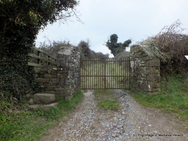
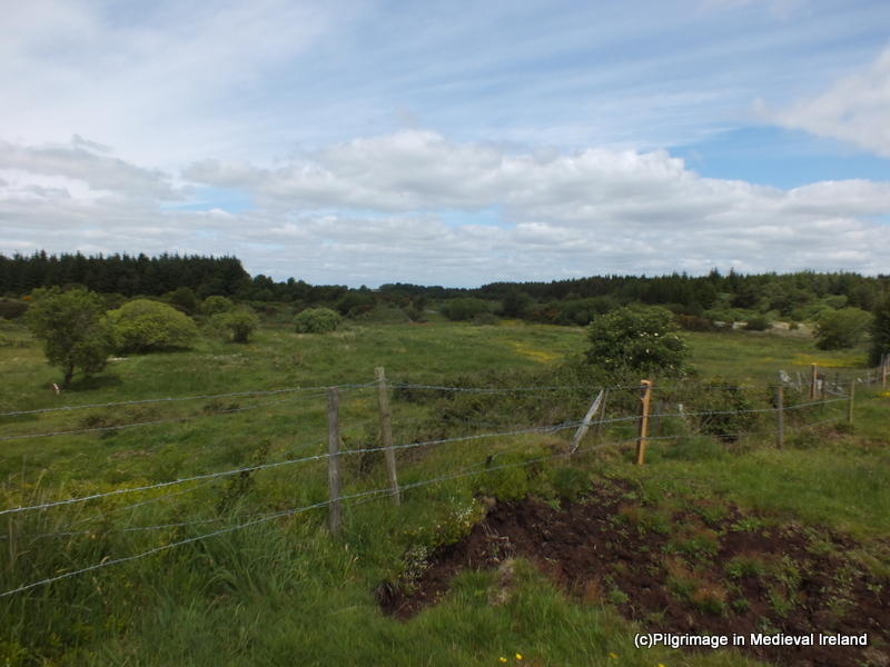
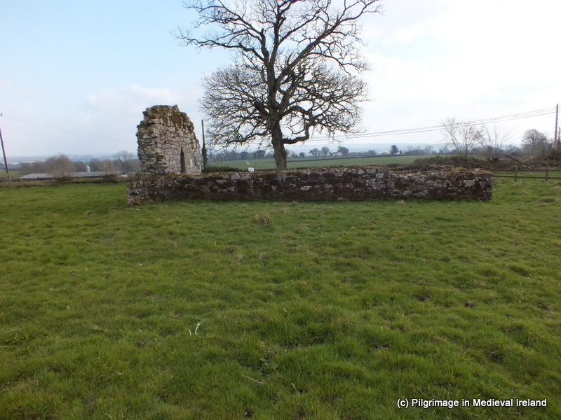
Kilgeever/Cill Ghaobhair is located in the most scenic of setting on the slopes of Kinknock around 3km outside of Louisburg in Co Mayo. The site is part of the Clew Bay Archaeological Trail.

Fig 1

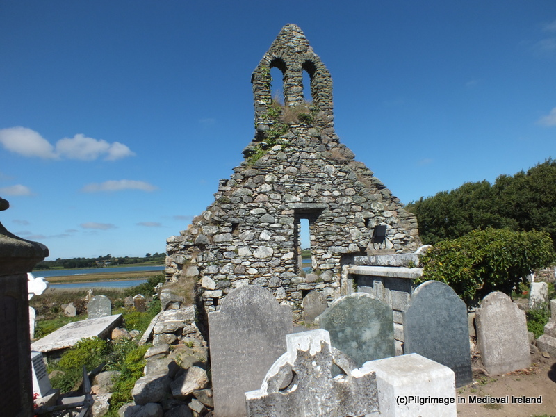
View of the medieval church at Kilgeever from the small laneway that leads to the site.

Local folklore holds that St Patrick came to Kilgeever having completed his fast of forty days and nights on the summit of Croagh Patrick. It is said that Patrick decided to build a church here and that he later sent St Iomhair one of his disciples completed the task. Some traditions would suggest that “Kilgeever” is the anglicised version of “Cill Iomhair” or the church of Iomhair. The Ordnance Survey Letters of 1838 translates the name as St. Geever’s Church.  Curiously neither variants of the saint’s name are found in Ó’Riain’s Dictionary of Irish Saints.

Alternatively the name may derive from Cill gaobhar, ‘the near Church’ (Corlett 2001, 130) or as the Schools’ Manuscripts Essays  for Louisburg(1937/38) state

Kilgeever- according to the interpretation of most people means “the windy church”.

Fig.2

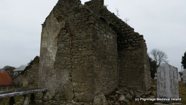
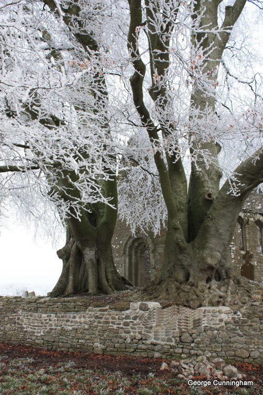
View of Kilgeever Church and graveyard.

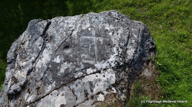
Almost nothing is known about the history of the site but it appears to have functioned as a parish church in the late medieval period. Today the site consists of the ruins of a multi-period medieval church surrounded by a historic graveyard, a holy well and penitential stations. At least three early medieval cross slabs are associated with the site suggesting some sort of early medieval activity. If there was an early medieval monastic settlement here as the name ‘abbey’ would imply no physical remains survive above ground.

Traditionally pilgrims visited here on the 15th of July the Feast of the Apostles and on Sundays.  The Ordnance Survey Letters of 1838 refer to a pattern formerly held on the 15th of July. There was also a tradition of visiting the site on the last Sunday of July. For some pilgrims it is a key component of their pilgrimage to Croagh Patrick and having completed their pilgrimage on the summit of Croagh Patrick they descend the mountain and end their pilgrimage at Kilgeever.  The ITA Files 1944 also makes reference to pilgrims visiting here from the 15th of August to the 8th of September with the annual pilgrimage day being the 15th of August.

Fig.3

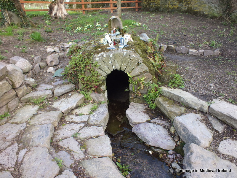
Holy well at Kilgeever

The main focus of devotion at Kilgeever is a small holy well located in the northwest corner of the historic graveyard that surrounds the medieval church.

The Ordnance Survey Letters of 1838 state

It is a good spring and much frequented by pilgrims especially for Sundays and on the 15th of July when a pattern is held, now at Louis Borough but which was formally held at the this well.

The traditional pilgrim stations begin at this holy well, located just inside the entrance to the historic graveyard. The well is known locally as “Tobar Rí an Dhomhnaigh” or “Our Lord’s Well of the Sabbath” and the 1st ed. (1839) Ordnance Survey Map record the name of the well as Toberreendoney (Anglicisation of the former).

The Pilgrim Rounds

The pilgrimage begins with the pilgrim walking clockwise around the well forming his/her intentions. The pilgrim then kneels at the well and recites 7 Our Fathers (Paters) & 7 Hail Mary’s (Aves) and the Creed.

Fig. 4

Holy well Kilgeever

The pilgrim stands and circles the well 7 times while reciting 7 Our Fathers, 7 Hail Marys and the Creed.  Once the perambulation is completed, the pilgrim kneels again at the well and recites 7 Our Fathers, 7 Hail Marys and the Creed. It was not uncommon for pilgrims to pick up 7 stones from the well as an aid to counting the rounds dropping one stone as each circuit of the well was completed.  The use of stones to count prayers is a common practice at Irish many Irish pilgrim sites especially those with complex prayer rituals.

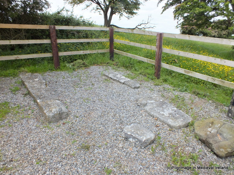
The pilgrim then walks to the three flagstones located to the south of the well where he/she recites 5 Our Fathers, 5 Hail Marys and the creed while kneeling.

The pilgrim then proceeds to a small rock outcrop known as St Patrick’s rock where he/she kneels and rites 3 Our Fathers, 3 Hail Marys and the Creed. This stone is reputed to bear the tracks of St Patrick’s Knees (ITA Files). In modern times some pilgrims have inscribed crosses on this rocks and others around where the stations are performed.

Fig.5

St Patrick’s Rock

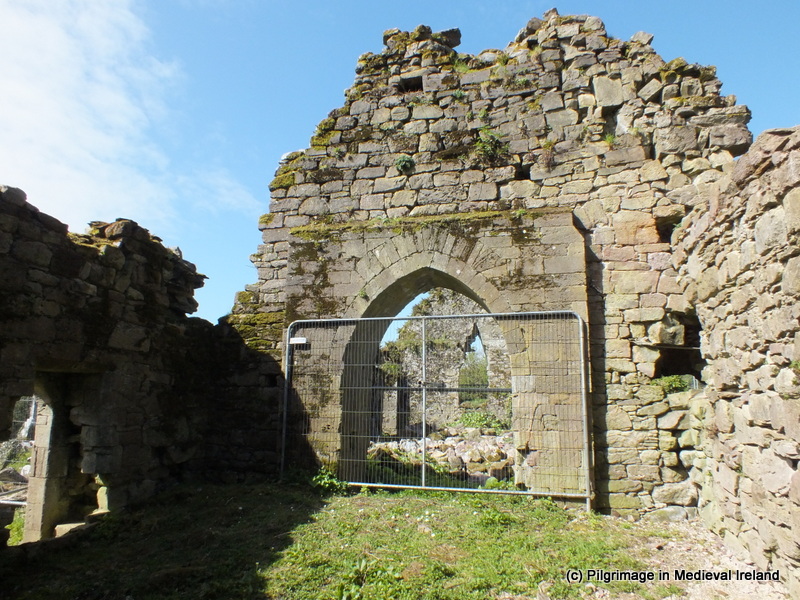
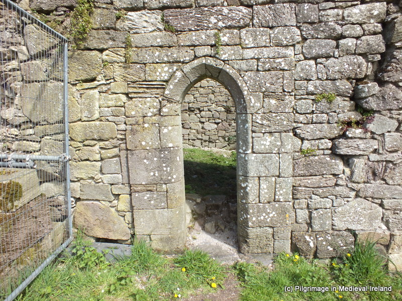
The pilgrim then walks to and enters the medieval church at the centre of the graveyard.

Fig.6

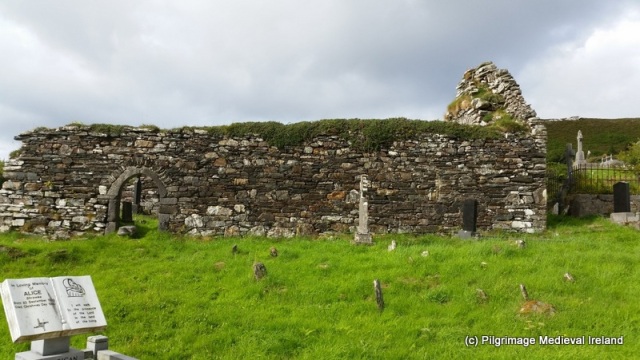
Kilgeever church is a multi-period church with a fifteenth doorway.

Within the interior of the church the pilgrim kneels and again recites 7 Our Fathers, 7 Hail Marys and the creed and pray for the souls of the dead.  In the 1940s it was common for pilgrims to leaving the church following along the west wall (ITA Files).

Fig.7

Pilgrim cross carved by modern pilgrims on 19th century graveslab within Kilgeever Church.

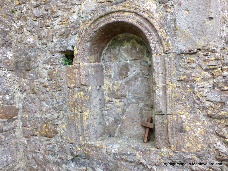
Some pilgrims continue a modern practice of scratching a cross into a late 19th century graveslab belonging to  the Mac Evilly family. When I visited the site in 2014, a number of  tiny stones were left on the edge of the slab. Other accounts suggest that in the mid-twentieth century pilgrims were in the habit of leaving votive offering in the aumbry within the church. This tradition was not noticed on my visit but a number of religious objects were left at the well.

Fig.8

Some votive offerings left at the Kilgeever Holy Well

Having left the church the pilgrim walks back to the well via a stream that runs the length of the western side of the graveyard.  If the pilgrim’s stations are being performed on behalf of a living person the pilgrim is to walk in the waters of the stream to the well. If the pilgrimage is being performed for the dead, the pilgrim walks along the edge of the stream.

Fig.10

Stream running along the western side of the site.

The pilgrimage is completed when the pilgrim circles the well a further 3 times prayer in honour of the Blessed Trinity. Before leaving the Holy Well pilgrims  are invited to pray for Henry Murphy of Castlebar who had the cross erected over the well (as indicated by an inscription on the cross).

A photo dating to the 1890s and part to the Wynne Collection at Mayo County Library shows pilgrims kneeling in prayer at the holy well in bare feet. This photo confirms what was a common practice at the time for people to complete such pilgrimages barefoot and even today at a small number of pilgrim sites pilgrims continue this practice.  The photo also shows that the well has changed little over the years with the exception of the  addition of the  cross which now surmounts it.

Fig.11

Early Medieval Cross Slab with an outline Greek cross found at Kilgeever. This is one of three cross slabs from the site.

Kilgeever is one of the most peaceful and tranquil places  to visit and it is just one of many interesting sites around Clew Bay area.

Fig.9

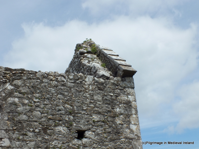
View of the east gable of Kilgeever church.

References

Corlett, C. 2001. Antiquities of west Mayo: The Archaeology of the Baronies of Burrishoole and Murrish. Bray: Wordwell.

Higgins & Gibbons 1993: J.G. Higgins & Michael Gibbons. ‘Early Christian monuments at Kilgeever, Co Mayo’. Cathair na Mart, 13, 32–44.

Irish Tourist Association Files for Mayo 1944.

The Schools Collection, Louisburgh (roll number 5128/9), Volume 0137, Page 005, 006,  026, 027 (http://www.duchas.ie/en/cbes/4428011/4368055)

http://www.louisburgh-killeenheritage.org/page_id__85.aspx

http://www.logainm.ie/en/37369

http://www.thestandingstone.ie


Walking The Saints’ Road in Co Kerry

Mount Brandon in Dingle Co Kerry is one of my favourite pilgrim sites. Traditionally pilgrims climbed in pilgrimage to the summit of the mountain on the 16th of May the feast of St Brendan.

Unicode

View of Mount Brandon from Reenchonail

I have just mapped the route of the Saints’ Road an old pilgrim path running from Ventry to the Summit of Mount Brandon using StoryMapJS.  So if for  virtual walk along the Saints’ Road follow the links below.

MB3


St Laserian at Lorum Co Carlow

I was hoping to have this post ready for the feast day of St Laserian  on the 18th of April   but better late then never.  St Laserian has strong associations with Co Carlow and I have discussed  the modern pilgrimage to St Laserian  at Old Leighlin Co Carlow in previous posts. The saint is also  associated with a place called Lorum  in Co Carlow.

According to folklore  when St Laserian returned to Ireland from Rome he set out in search of a location to build a monastery.  When he came  Lorum  (a few miles south-east of Muinebheag (Bagenalstown)) he stopped on top of a large hill . The saint was so impressed by the area that he decided to build a monastery here. God however had other plans for him, and while he knelt in prayer an angel  proclaimed ‘ Go where you shall see the first shinning, and there shall your religious house be established’ ( O’Toole 1933, 17).  Taking heed of the angel the saint  set off again on his search which ended when he arrived  Old Leighlin  which became the site of his  monastery.

Lorum (Leamdhroim in Irish) appears to have been the site of a religious foundation. Gwynn and Hadcock (1970, 397) recorded that Lorum was an early medieval monastery dedicated to  St. Laserian . Brindley notes in 1204 the Bishop of Leighlin was confirmed of his possession of lands including ‘Lenidruim’ (Lorum) (Cal. papal letters, 18). The church  at Lorum was valued at 3 marks in the 1302-06 ecclesiastical taxation of Ireland (Cal. doc. Ire., 250) and by the late 16th century it was in ruins.  The Ordnance Survey Letters for Carlow recorded Steward, writing in 1795, noted that the 18th of April, the feast of Laserian was celebrated at Lorum and  until  the  1830s a  pattern day was held here.

062

Loram Church of Ireland Church

All trace of this monastery and medieval church have long disappeared.  Today Lorum  consists a stunning Church of Ireland Church  built circa 1830 with a historic graveyard  on its western side . The  curve in the road on the east side of this church may tentatively reflex the line of an earlier medieval enclosure.

lorum

View of Lorum Hill showing the curve in the road on the east side of the church (taken http://map.geohive.ie/mapviewer.html)

Within the historic graveyard are the ruins of  a post medieval church. The structure is  in poor condition  and with the exception  of the west gable only the foot prints of the other walls survive.  The upstanding gable appears to incorporated  stones from an earlier church.

20160322_113324-001

Ruins of  post medieval church at Lorum.

The remains of an 18th century porch with red brick  in the fabric is  attached to the  exterior of west gable of the church.


20160322_113808

Porch attached to west gable of Lorum Church

In 1837 Lorum church was described as ‘an old building, containing two modern tombs of the Rudkin family, has been recently repaired’ (Lewis 1837, 312).  The Ordnance Survey Letters  for Carlow (1837-40) recorded that at ‘

Lorum, there was, it is said, an old Church before the present Parish one, which is now falling to ruin, was erected. The spot where it stood is shown in a field, a few perches to the northeast corner of the Parish Church  and a few yards to southwest corner of a Church (C of I church) which is now in progress of being built (O’Flanagan 1934, 311).

The ITA Survey of 1945 identifys the ruined church as the remains of an 18th century Church of Ireland Church and the medieval church as being located as a low-rise of ground inside the graveyard. Both churches were replaced by a  seven-bay Gothic Revival Church with buttresses and parapet built c. 1838 and designed  by Frederick Darley.

063

Church of Ireland Church at Lorum built 1838

Close to the church are the ruins of a small post medieval house which shows signs of rebuilding and alterations.

20160322_115906-001

Post medieval building at Lorum

A plain granite base of a high cross provides the only physical evidence of early medieval  activity at the site.

20160322_113540

Base of high cross at Lorum

The remains of a second  early medieval cross are found 200m to the west of Lorum graveyard. The  cross is located on the north side of  east-west running bohereen.

20160322_115128

Bohereen leading to Lorum cross and cairn

The monument consists of  a medieval cross shaft set in a cross base  sitting on top of a cairn of stones and earth.


This slideshow requires JavaScript.

Lorum is associated with two holy wells. According to ITA Survey (1945),  a well dedicated to St Laserian was located to the north  the old graveyard. The well was not recorded on the 1st ed OS 6-inch map for the area but the files state it was covered by well house  and located northnorthwest of the  church.  The farmer who owns the land the well was located on told me there was no longer a well here and he had not heard of a holy well in this location before.

A holy well dedicated to St Molaise ( the Irish for Laserian) is located to the east of the old church.  The 1st ed OS 6-inch  marked the well as St Molappoge’s well. The well which is now dry is  stone-lined  and rectangular in shape. It is  covered by  a  large lintel stone. The well is in reasonable condition but is no longer visited by pilgrims.


20160322_121324

St Molappoge’s  holy well


St Laserian is no longer  venerated in the area and all focus of the saint has moved to Old Leighlin.  This is a lovely place to visit and you can see why St Laserian wanted to settle here.

References

Brindley, A. 1993. Archaeological Inventory of County Carlow. Dublin: Stationery Office.

Gwynn, A. & Hadcock, R. N. 1970. Medieval Religious Houses in Ireland. Dublin: Irish Academic Press

ITA Survey of Carlow 1945

Lewis, S. A. 1995. A topographical dictionary of Ireland:London : S. Lewis & Co

http://www.buildingsofireland.ie/niah/search.jsp?type=record&county=CW&regno=10301911

O’Flanagan, Rev. M. (Compiler) 1934 Letters containing information relative to the antiquities of the County of Carlow collected during the progress of the Ordnance Survey in 1839. Bray.


Urlaur Abbey Co Mayo

Urlaur Friary,  a Dominican foundation,  on the shores of Urlaur Lake in Co Mayo is one of Ireland’s best kept secrets.

289

Urlaur Friary Co Mayo

The friary was founded  around the year 1430 and was dedicated to St. Thomas.  The friary survived the  Reformation and in the early 17th century, the property was confiscated and handed to Viscount Dillon, a local loyal landlord. The community continued to reside here and the last friar of Urlaur, Patrick Sharkey, died in 1846. He lived in a cottage beside the ruins of friary and he sometimes said mass within the church.

The church is entered through the west gable via a pointed doorway with hooded moulding. A carved  head in poor condition sits above its apex.

DSCF2104

West gable of Urlaur Church

Above the door is a small elaborate triple light window with hooded moulding.

The interior of the church is quiet plain and the floor is covered with gravel.

298

View of interior of Urlaur church facing the east gable.

The north side of the nave of the church appears to have been extended to accommodate an aisle. The remains of an arch  on the north side of the west gable wall suggests the aisle may have been divided from the nave by arches and columns.

The east gable is also well preserved and  has the remains of  an elaborate tracery window.

The domestic buildings for the friary also survive and abutts the east end of the  south wall of the  church.

345

The east gable of Urlaur Church and domestic buildings for friary.

A pointed doorway in the south wall of the church leads into a vaulted room (part of the domestic building) abutting the exterior south wall of the church.

A second door in the middle of the  south wall provides access to the exterior of the church and the domestic buildings.

DSCF2166

View of doorway in the south wall of the church.

The remains of the domestic building consist of a north-south aligned two storey building. The ground floor has a number of vaulted rooms.

Access to the second floor of the building is provided by a stone stairs.

327

Stone stairs leading to the upper floor of the domestic buildings

The upper floor is unroofed and may have been the dormitory for the friars.

316

A square tower for want of a better word is built against the south wall. This is probably the garderobe.


During the 19th century Urlaur was the scene of a pattern day held the on 4th of August, the feast of St Dominic. A field beside the church was marked as the pattern field on the 1839 1st ed OS 6-inch maps for Co Mayo.

urlaur

1st ed. OS 6-inch map of 1838 depicts a field known as the Pattern field beside the abbey.

The pattern despite some ups and downs has continued to the present day and an  annual mass  reintroduced in 1914 is still held here each year on the  4th of August.


Ardpatrick Co Limerick

St Patrick is associated with many wonderful sites around Ireland,  Ardpatrick Co Limerick is one of my favourite. Located on the edge of a village of the same name, the site is about six miles south of Kilmallock on R512, on the road to Kildorrery in the county of Cork. Sitting on top of a large hill  the site consists of  the ruins of an early medieval  ecclesiastical settlement,  consisting of a ruined church surrounded by a modern rectangular graveyard and the stump of a round tower.  The site is held to date to early medieval period and the partial remains of  large  enclosure that once surrounded the site is still visible. Within the enclosure are earthworks of possible buildings, fields banks, enclosures and a road.

ard - Copy

View of Ardpatrick from the air ( Bing maps)

The name Ardpatrick comes from the Irish ‘Ard Phádraig’  which means the ‘Height or Hill of Patrick’.  According to local tradition St Patrick founded a monastery here in the 5th century.

A story in the late 9th century work Bethu Phátric, The Tripartite Life of St Patrick, tells us that when Patrick sought a site for the church on Ardpatrick, Derbhall, the local leader, opposed him. He told him that he would believe only if St Patrick removed part of the mountain wall to the south so that he could see Loch Long in the land of Fir Muí Féinne. St Patrick prayed and the mountain melted forming a gap, Bealach Leáite, the Pass of the Melting (Dowd 1896, 49; Limerick Diocesan Heritage).

In the ensuing centuries the  Ardpatrick was ruled by abbots drawn from the Déisí, the ruling Sept of An Déis Bheag, the territory in which the monastery was situated. The church became a very important and powerful site. It had strong links with Armagh and collected Munster contributions to Armagh. Torlogh O’Connor plundered the church at Ardpatrick in 1127AD and in 1129 Cellach, bishop of Armagh, died at Ardpatrick  on Monday 1 April.  The O’Langans were hereditary coarbs of Ardpatrick and the lands here remained in their possession and a group  known as the ‘Clerks of Ardpatrick’,  up to the 16th century (Fleming 2009 ,6).

Ardpatrick Archaeological remains

As the name suggest the ruins  at Ardpatrick sit at the top of a large hill to get to the summit you follow  a small track from the edge of the  village.

The hill is steep but when you reach the top of the hill you will be rewarded with magnificent views of the surrounding countryside.

This slideshow requires JavaScript.

Today the all that remains of this once great site are the ruins of multi period church  which is covered in a thick growth of ivy which makes it difficult to examine in detail.  According to Ó Carrigáin (2010 131)

‘ apart perhaps from the north end of the west wall, none of its fabric seems to be medieval. It does incorporate large blocks that probably come from a per-Romanesque church.


IMG_5756

View of the ruins of the church at Ardpatrick

A number of carved stones from windows etc are found scattered around  the site and the interior of the church is filled with historic graves.

The church and graveyard are surrounded by a rectangular walled  enclosure.  Ó Carrigáin (2010, 131-132) points out that one of the stones in the stile at the  west end of this enclosure  incorporates an upside down door lintel which was part of an earlier pre-Romanesque church.

077

Upside down door lintel reused in stile. This stone likely came from a pre-Romanesque church that once stood at the site (Ó Carrigáin 2010, 306).

This slideshow requires JavaScript.

In the past a holy well stood to the southwest of the church.

map ap

1st ed. OS 6 inch map of Ardpatrick

The well is now filled in but was once circa 40 feet deep, faced with stone, and had steps leading to it.  According to legend, cattle are said to have been cured by its water. People visited the well seeking cures for lameness, rickets and rheumatism also used it.

According to the Folklore Collection Schools Manuscript of 1937

There is a holy well now nearly filled up on the hill here. The water lay about 15ft from surface, people said that if on looking down you did not see your reflection in the water you would die before the current year ran out.

DSCF2167

Carved detail of a window embrasure in the church fabric

Outside the graveyard  wall are the stump of a 11th-12th century round tower  built of dressed stone. Given its location it must have dominated the landscape when built. The tower collapsed in a storm in 1824 and local legend tells of a peal of 7 silver bells which once hung in the tower.


This slideshow requires JavaScript.


According to the Schools Manuscripts (1937) folklore about the tower said that the tower was destroyed

When Murrough the Burner was coming from Cashel his soldiers burned Ardpatrick village which my informant says stretched west by south from the old tower. A party of soldiers on guard in the tower were playing cards. They played on top of a powder keg. One of them ‘hit the keg a welt of his fist’ upsetting a candle into the powder. The resulting explosion damaged the tower which was still further damaged by lightning.

It was also said that a subterranean passage supposed to exist between the round tower & the old abbey.

Another interesting feature that survives at the site are the traces of an ancient road way.

ard - Copy

Aerial view of site (Bing Maps) showing the line of the Rian Bó Phádraig

The old road known locally as the Rian Bó Phádraig has discussed this road in a previous post of St Patrick to find out more follow the links.

DSCF2245

The remains of the old road known as the Rian Bó Phádraig.


References

Fleming, J. 2009.  The formation of the church in Limerick’. In Limerick History and Society, 1-15.

https://pilgrimagemedievalireland.com/2016/02/03/holy-cow-the-miraculous-animals-of-the-irish-saints-part-three-st-patricks-cow-and-the-rian-bo-phadraig/

http://www.limerickdioceseheritage.org/Ardpatrick/textArdpatrick.htm

Irish Folklore Collection Schools Manuscripts Ardpatrick Co Limerick http://www.duchas.ie/en/cbes/4922041

ÓCarrigáin, T. 2010. Churches in Early Medieval Ireland. London: Yale University Press.

Ó Danachair, C. (1955). The holy wells of Co. Limerick. JRSAI Vol. LXXXV, pt. II, pp. 193-217.


A History of Pilgrimage to Monaincha, the Holy Island of Loch Cré

Monaincha in North Co Tipperary was one of medieval Ireland’s most important pilgrim destinations. It’s a site I have visited many times and have a great fondness for. Located  a few miles from the historic town of Roscrea it is a wonderful place to visit.   I am delighted to present a guest blog post  by historian and organiser of the wonderful Roscrea Conference  George Cunningham about the history of Monaincha.  George has carried out much research on the site over the years.  This post provides an over view of the pilgrimage history  of what was at one time one of Ireland’s most important pilgrim destinations. A History of Pilgrimage to Monaincha, the Holy Island of Loch Cré by George Cunningham Monaincha also know as the 31st Wonder of the World, the Island of the Living, was once Munster’s most famous place of pilgrimage.

View of  of approach route to Monaincha Abbey and pilgrim site.

View of approach route to Monaincha Abbey and pilgrim site.

Yes, indeed, there is an island of the living in the heart of Ireland a little more than three kms east of the town of Roscrea on the provincial borders between Munster and Leinster. This now drained Holy Island (in fact there were two islands as Giraldus Cambrensis attested in the 12th century) sits surrounded by cutaway bog. Its noble ruins consist of a beautiful 12th century Hiberno-Romanesque nave and chancel church with a later transept, and a twelfth century high cross placed on an earlier base.

DSCF0652

Romanesque Doorway of the surviving church at Monaincha.

The cross was re-erected in the late 1940s (using a cement shaft!) and features the crucified Christ in a long robe in the style of pilgrim crosses from Lucca in Italy. Similar features may be seen at nearby Roscrea and at Cashel.

DSCF0650

High Cross at Monaincha depicting the crucified Christ in a long robe in the style of pilgrim crosses from Lucca in Italy.

The island was the retreat of neighbouring saints, Canice of Aghaboe and Cronan of Roscrea, both of whom used the place as a sanctuary of personal peace. It became a main centre for the Céli Dé and pilgrims were attracted to it from all over Ireland and from abroad. The Augustinian Canons continued the pilgrimage tradition in the 12th century and the prior of the Island – usually an O Meachair from the ruling clan of the area – figures prominently in the Papal letters during medieval times. A huge revival of pilgrimage at the beginning of the 17th century saw thousands flock to the site to do the ‘rounds’. A diary of a German pilgrim Ludolf von Munchhausen, who travelled from northern Germany, as a curious tourist rather than as a pilgrim, in Spring 1590/91, has been recently translated. The martyred bishop of Down and Conor, Conor O’Devany was here shortly before he was executed. Monaincha received the same plenary indulgences remission as famous continental sites such as Santiago de Compostella.

monaincha dec 2010 049 ed 4

View of Monaincha on a frosty day.

In the 18th century the new landlords, the Birches reserved the place for their own burials and its fame faded into folk memory, albeit always known as ‘the Holy Island’ although it was drained over 200 years ago. Its exquisite Romanesque architecture in its remote bog setting always attracted the aficionado but it wasn’t until the early seventies that its history and international importance began to be appreciated locally and the pilgrimage to the island revived. The Cistercians of Roscrea held vespers there during the millennium conference in 2000 the first time in centuries that the psalms rang out across the great red bog of Éile. An app guided tour from Roscrea to Monaincha narrated by George Cunningham may be sourced from the site  http://www.roscreathroughtheages.org

References and Links

http://www.roscreathroughtheages.org/index.html

App guided tour for Roscrea town  http://www.heritagetrails.ie/explore/roscrea-heritage-trail/

App guided tour for Monaincha   http://www.heritagetrails.ie/explore/monaincha-heritage-trail/

http://www.roscreaonline.ie/content.asp?section=291

The Derrynaflan Monastery and Easter Pilgrimage

Derrynaflan is best known for its medieval metal work, including a two-handled chalice known as the Derrynaflan chalice, on display in the  National Museum of Ireland.

derrynaflan-hoard

The Derrynaflan hoard (the chalice and associated ecclesiastical objects)

The  chalice along with a paten, a liturgical strainer and basin were part of a hoard of treasure found by metal detectorist on land close to the  monastery of Derrynaflan Co Tipperary.  The complications, surrounding their discovery, helped to instigate Ireland’s current metal detecting laws which make it illegal for anyone to engage in metal detecting without a licence.

As a child I remember going on a school trip to the National Museum at Kildare St. After all these years I still remember  this visit clearly, along with  our teacher pointing out this treasure (Derrynaflan Chalice) found in my home county. I also purchased a small booklet in the museum shop on the chalice which I still have, once a nerd always a nerd.  The craftsmanship of the chalice and other objects  is  true breathtaking.

Derrynaflan

Decoration on the Derrynaflan paten (a plate used to hold the host during the celebration of the Eucharist).

Location

The hoard is associated with the monastery of Derrynflan.  The monastery  sits on an island  in Littleton  raised bog,  in the townland of Lurgoe, approx 11km from the  modern town of Thurles in Co Tipperary.

Derrynaflan_01721

Aerial shot of Derrynaflan (from the Slieveardagh Rural Development http://www.slieveardagh.com/history/towns-and-villages/derrynaflan/).

In early medieval times  it was located close to the territorial boundary of the territories of the Éile and the Éoghanact.  As you can see from the photo above much of the surrounding bog has been processed and removed by Board na Mona, giving the land a desolate and unappealing vista.  One can only imagine what his site and its surrounding landscape would have looked like in medieval times.

Although  built-in the middle of a bog, Derrynaflan was far from isolated and recent archaeological excavations in the surrounding bogland, has revealed the presence of several bog roads and trackways, some of which line up with the site.  These roads and tracks linked the monastery to the wider world.

The Irish and Latin Lives of St Ruadhán  recounts an interesting tale concerning one of these roads.  St Colmán Mac Dáirne of the monastery of  Daire Mór  decided to bring a gift of butter to St Ruadhán who at the time was residing at Derrynaflan. Conn Manning (1997) has identified the monastery of Daire Mór   as Longfordpass alias Durrihy, located north of Thurlas.   Colmán placed the butter in a vessel which was carried by two oxen and set off on his journey. We are told that he two monasteries were divided by bog but Our Lord miraculously made a road spring up through the bog so that Colmán could deliver the butter.

Founding Saints

Derrynaflan was  founded by  St Ruadhán of Lorrha in  the 6th century (Harbison 1970, 226) but the site gets its name from  two other saints who lived here during the 9th century.  In Irish Derrynaflan  is Doire na bhFlann,  in English the name means ‘the wood of the two Flanns’.  This placename  remembers two  saints both called Flann (meaning red or blood-red) who are associated with the site.  The saints were Flann son of Foircheallach and Flann son of Dubh Tuinne (Conna), both acted as co patrons of the area. The calendars of Irish saints note Flann Foircheallach died in  825 and his feast was commemorated in the 21st of December.

The monastery acquired its present name by the association with two prominent clerics of the early 9th century, Fland mac Duib Thuinne of Dairinis who died in 821 and Fland mac Fairchellaig, abbot of Lismore who died in 825 (ibid.).

Derrynaflan was linked to the Ceilí Dé movement  and the annals suggest links to other Céili Dé churches at  Lismore, Emly and Cork.  Additionally it is included in a list of sites in ‘union’  with Máel Ruain, and the asceticism practices by Flann son of Dubh Tuinne is elsewhere specified  in the rule attributed to  Máel Ruain who was the patron of Tallaght (Ó’Riain 2011, 345).

The site today

The approach to the Derrynaflan is little bit difficult but so worth the effort.  I visited here during the summer with Conor Ryan of the South Tipperary Development Company who is currently working in a project to develop an   The Derrynaflan trail  linking this site and other church sites such as Holy Cross Abbey in east Tipperary Slieveardagh area.

We approached the site from the north  the townland of Liskeveen and  followed a small  surfaced bog road  and then headed cross county  through some scrub.  It is also possible to  approach  the site from the  south.

1-DSCF8985

Approach to Derrynaflan from the south

After a little bit of  walking  we came to the base of a hill  and were rewarded with view of the ruins of the monastery sitting on top of a hill.   The monastic site  consists of a series of earth work and the ruins of a church and  a single wall of another monastic  building.  The island was originally enclosed by a bank and outer fosse (ditch) which is visible only in places and the eastern side of the enclosing bank and fosse are now covered by a build up of bog and peat (Ryan 1980, 10).

1-DSCF8990

View of Derrynaflan church

Today the most visible remains are the church. This is a nave and chancel church with two phases of construction. The nave of the church appears to be pre-Norman, a separate church in its own right. In the 13th century the chancel was added on this earlier church then became the nave of the new building.

Interior of Derrynaflan Church

Interior of Derrynaflan Church

Only the  walls of the chancel  in the north, south and east survive to any great height .  The earlier church (nave) was built of coursed Cyclopean limestone masonry (large blocks), of which only the lower courses of the south wall survive (Ryan 1980, 11).

The east gable contains two single-light trefoil-headed windows, while there are three single-light trefoil-headed windows in the south wall.  At the east end of the south wall  there is a re-used Romanesque window which was used to frame a decorated sandstone piscina.

1-DSCF9007

Romanesque window reused to frame the piscina

Within the  interior of the church  there is a triangular-shaped gable finial with socket for a cross belonging to the original roof of the 13th-century church.

1-DSCF9016

Stone roof slates

Along the top of the north side of the east gable are stone roof slates,  additional stone roof slates from the medieval chancel were also found during previous excavations (Ó Floinn 1985, 37).

1-DSCF9032

East gable of Derrynaflan church

Gobán Saor

Derrynaflan is also associated with a mythical figure called the Gobán Saor.  The Gobán  was a highly skilled smith or architect in Irish history and legend.  Tradition holds he was responsible for  building  many of Ireland’s castles and churches including Holy Cross Abbey.

Local tradition holds that the Gobán Soar was buried at Derrynaflan and the 1st edition Ordnance Survey map marks the site of  his grave to the north-east of the church.

1st ed Ordnance Survey map of Derrynaflan from http://maps.osi.ie/publicviewer/#V1,617960,649614,6,8

1st ed. Ordnance Survey map of Derrynaflan (from http://maps.osi.ie/publicviewer/#V1,617960,649614,6,8)

Farrelly (2011) notes that White writing in  1892 say

‘further down the slope to the north, are the graves of the Gobann and his wife and two children. Stones of coffin shape mark the place and bear quaint figures and curious celtic tracery. Heretofore, these relics were religiously preserved, but latterly they have suffered in some ways. A barabarian smashed one of the stones some years ago and obliterated the tracves with a chisel’. Traditionally the Gobaun was said to have been Grand Master of the ancient order of Freemasons in Ireland (ibid).

Today the area  is  an area defined by a timber fence.   Inside the fence are three  very worn medieval grave slabs one which is held to mark the Gobán’s grave. I will come back to the Gobán again in the new year as I think this very interesting character is deserving of his own blog post.

1-DSCF9035

Grave of Gobán Saor

  Easter Pilgrimage

This quiet site is transformed into an annual place of pilgrimage at Easter time when there is a celebration of a dawn mass on Easter Sunday. The tradition was started by Canon Liam Ryan, PP, Killenaule-Moyglass, in the 1990s and attracts large numbers of pilgrims from the surrounding areas.  I am hoping to attend this pilgrimage in 2014.

My friends at Abarta Heritage have a great a audio guide for this and some of the other sites in the area .

References

Byrne, F. J. 1980 Derrynavlan: the historical context. In JRSAI 110, 116-26.

Farrelly, J. 2011. ‘Derrynaflan’ http://webgis.archaeology.ie/NationalMonuments/FlexViewer/
Ó Floinn, R. 1987 ‘Derrynaflan’, Lurgoe: Monastic settlement. In I. Bennett (ed.), Excavations 1986: summary accounts of archaeological excavations in Ireland, 33. Bray. Wordwell.
Ó Floinn, R. 1988 ‘Derrynaflan’, Lurgoe: Monastic settlement. In I. Bennett (ed.), Excavations 1987: summary accounts of archaeological excavations in Ireland, 24-5. Bray. Wordwell.

Manning, C.  1997.  ‘Daire Mór identified’ Peritia 11, 359-69.
Ryan, M. 1980 An Early Christian hoard from Derrynaflan, Co. Tipperary. NMAJ 22, 9-26.

http://www.abartaheritage.ie

http://www.abartaheritage.ie/product/derrynaflan-trail-audio-guide/

http://www.nationalist.ie/news/your-community/easter-sunday-dawn-mass-planned-for-famed-derrynaflan-site-1-4929037

In search of a cure: the pilgrimage of James Shee to Lady’s Island, Co. Wexford in 1694.

The 17th  and 18th centuries in Ireland were a very interesting time in the history of Irish pilgrimage. Society experienced many changes, the Catholic religion practised by the majority  became second to Protestantism the new religion of the state. It was a violent time of political upheaval and social change in which various conflicts culminating with the Cromwellian conquest  of  1649-53, and the later Williamite Wars  of 1689-91, resulted in a major shift in the social structure of Irish society, with the Irish catholic aristocracy being largely replaced by a new English protestant ruling class.  Additionally churches and monasteries were dissolved, as were the monastic orders who controlled them, continuing the work of the reformation initiated by Henry VIII in the 16th century. State laws were imposed to curtail the religious freedoms of those who did not follow the state religion. Monasteries and churches were stripped of their valuables and many of the precious relics of the medieval period such as the Bachall Íosa or the miraculous statue of Our Lady of Trim were destroyed by iconoclasts. During the medieval period  the majority of pilgrim sites were controlled by religious orders but  following the dissolution the church often had little input into how the  sites  were accessed. Pilgrimage in  a sense now came to be  controlled of the pilgrims. Pilgrim rituals adapted and changed  to these new circumstances, becoming more fluid and less formal. Despite the efforts of  the State to suppress pilgrimage, the practice continued and in some cases thrived at a local and regional level.

One of the more interesting stories of pilgrimage from this period is found in the papers relating to the Power Shee family in the National Library of Ireland.  Within these records are the papers of Mary Kennedy (1733-1784) whose maiden name was Shee. Mary transcribed a list of family births and deaths from her father William Shee’s prayer-book. The original list was written by William Shee (1694-1758) and his father, James Shee (1660- 1724) of Derryhinch/Derrynahinch Co Kilkenny.

Mary’s grandfather James was born in Derryhinch/Derrynahinch in 1660 to William Shee and Ellen Rothe. Both William and Ellen were descendants of prominent Kilkenny Merchant families. James began a tradition later  continued by his son William of recording important life events in his prayer book. The list began with the date of James marriage to Mary Trapps (1660-1706) on the 25th of May 1684 (Ainsworth & MacLysaght 1958, 250). He subsequently recorded the birth of their children.  Their first child William was born Friday the 8th of May 1685 but died sometime later. A second son George was born on the 11th of April  1686,  the following year a daughter called Ellen was born ‘…Saturday the last of December 1687 between 7 and 8 in the morning.’  Elizabeth was born in June 1690 and a son Henry on  the 13th November 1691. Another son who was also called William was born  in 1693.  In the prayer-book James writes the child  was taken very ill on the  20th of March 1693 and wrote ‘I promised to make him a Church man if I found he had vovation’ but the  boy died on the 8th of May the following year. Shortly after the child’s death another boy child was born in 1694 and he was christened  William (Ainsworth & MacLysaght 1958, 250-251).

Some time in 1693/94  he writes

My daughter Ellen being very ill, I promised to make a pilgrimage to Our Lady’s Island, in honour of Our blessed Lady. This performed’ (Ainsworth & MacLysaght 1958, 250

Having lost two children James and his wife must have been very frightened for Ellen. We do not know what sickness the child had but  the mortality rate for children was very high in 17th century Ireland. James and his wife are likely to have been able to afford medical care but as there had been few medical advancements since medieval times medical intervention had limited success. The death of children from what are today preventable and curable illnesses was a harsh reality for parents rich and poor.The decision for James to undertake a pilgrimage and to turn to the Our Lady for help is very understandable in the context of the time. Throughout the medieval period and up to early modern times there was a very strong belief that many diseases were caused by divine intervention. There was also a very strong belief in the power of the saints to heal and certain pilgrim sites were known for their healing powers. Even today there are holy wells around the county held to have the power to cure ailments related to certain parts of the body such as eyes, skin, and limbs etc. that still attract pilgrims in search of a cure. Vows of pilgrimage undertaken in times of crisis were common throughout the medieval and post medieval period.  Additionally it was not uncommon a person to perform pilgrimage on behalf of a loved one who was too ill to travel.

James’s daughter Ellen was 6 or 7 years old when she fell ill and was too young and sick to undertake a pilgrimage on her own, so it was logical that her father would go on pilgrimage on her behalf.  Lady’s Island was located in the southeast corner of Wexford in the barony of Forth and Bargy some 80km from Derryhinch. During the 17th century a unique dialect of old English called Yola  was widely spoke by the inhabitants of this area of Wexford. The language of the area would have been difficult to understand for outsiders like James.  The journey to and from Kilkenny would have taken a few days to complete.  So why would James have travelled here?

LadysIslandDPJ1-30

Lady’s Island 1833 taken from The Dublin Penny Journal, Volume 1, Number 30, January 19, 1833

Lady’s Island  is still an active pilgrimage site today.  Tradition holds it has been a place of pilgrimage from the 6th century and it continues to attract pilgrims to this day. For the purpose of this post I will only focus on the evidence for pilgrimage here in the 17th century.

During the 17th century Lady’s Island was a pilgrimage site of regional importance. In the early 1607 Pope Paul V issued a plenary indulgence to all who visited here on the Feast of the Nativity of Our Lady (8th September) and on that of the Assumption (15th August).

Lady’s Island was also  known as a place of healing. An account of the island written in the 1680’s  states of the island

a church, builded and dedicated to the glorious  and immaculate virgin Mother; by impotent and infirme pilgrims,  and a Multiude of persons of all Qualities from all provinces  and parts of Ireland, daily frequented, and with fervent devotion visited, who, praying and making some oblacions, or extending charitable Benevolence to Indigents there residing, have there miraculously cured of grievous Maladyes, and helped to the perfect use of naturally defective Limmes, or accidentally enfeebles or impaired Sences.  (Hore 1862,  61)

Given the site’s status and its association with healing it makes sense that James would come here. Unfortunately he does not record anything of this pilgrimage other than it was completed. Given that the saints power was held to be at  its strongest on the saints feast day its likely. if timing permitted, that the pilgrimage would have tried to target one of the Marian feast days.

According to Colonel Solomon Richards, writing in 1682, the ‘most meritorious’ time to visit Lady’s Island was  between the 15th of August and the 8th of September (Hore 1862, 88)

Richards also describes the ritual practice of the pilgrims and we can assume that James completed his pilgrimage in one of the manners described below:

And there doe penance , going bare-leg and bare foote, dabbling in the water up to the mid leg, round the island. Some others goe one foote in the water, the other on dry land, taking care bot to wet the one nor to tread dry with the other. But some great sinners goe on their knees in the water around the island and some others that are greater sinners yet, goe three times round on their knees in the water.

1-DSCF1002

Modern pilgrims walking along the edge of Lady’s Island

According to Richards the pilgrimage culminated with the making of offerings at the chapel on the Island. This was most likely the ruined medieval church.

1-DSCF0869

Ruins of the medieval church on Lady’s Island

Having completed his pilgrimage James would have returned home. Ellen recovered from her illness and lived to adulthood  and is recorded to have married William Mulhall. James continued to write the births and deaths of his family in his prayer-book and following his death in 1724 the tradition was continued by his youngest child William.

James and Ellens story is one that was paralleled in medieval times and even modern times, and shows how a father was prepared to do all that he could to save his child .

References

Ainsworth, J. & MacLysaght, E. 1958. ‘No 20, Survey of Documents in Private Keeping:Second Series’ Analecta Hiberbica, Vol. 1, 3-361; 363-393

Church Records pertaining to the Shee family at http://records.ancestry.com/James_Shee_records.ashx?pid=52588493

Gillespie R. 1997. Devoted People. Manchester: Manchester University Press, 90-91.

Hore, H. 1862. ‘Particulars Relative to Wexford and  the Barony of Forth: By Colonel Solomon Richards, 1682.’ The Journal of the Kilkenny and South-East of Ireland Archaeological Society, Ser. 2, Vol. IV, 84-92.

Lady’s Island, County Wexford, in 1833. http://www.libraryireland.com/articles/LadysIslandDPJ1-30/index.php

Lady’s Island website http://www.ourladysisland.ie/

National Library Manuscripts. Reference #32383: Power O’Shee Papers (from 1499), the property of Major P. Power O’Shee, of Gardenmorris, Kilmacthomas, (now in the National Library of Ireland), relating to the families of Shee of Sheestown, Co. Kilkenny and Cloran, Co. Tipp., and Power of Gardenmorris. XX (1958).

.

Molana Abbey, Co Waterford

Molana abbey has been on my list  of  places to  visit for a such a long time and I finally got my chance this week and boy was it worth the wait!!

The abbey is  located  on an island in the Blackwater estuary on the  Ballynatray estate just outside of Youghal. On private property the site is open to the public during the summer months on  Tuesday, Wednesday and Thursdays.

1-DSCF0264

View of Molana Abbey, hidden among the trees

History of the Molana

Molana was  founded in the 6th century by a little known Irish saint  called  Maol Anfide, a contemporary of St Mochuada of Lismore. The saint  built a monastic settlement here on a small island  called Dairninis  or the ‘island of  the oak’ . No architectural evidence remains of this early settlement and today the ruins on the island date to the late 12th and  13th century.

In 1806 Dairninis  Island was joined to the mainland by a causeway and bridge  by Grice Smyth the then owner of the Ballynatray estate.  I was delighted to see oak trees still growing on  the island and along the causeway continuing the tradition of the place-name origins for the site.

1-DSCF0263

Causeway leading to Molana Abbey

Turtle Bunbury’s excellent blog post Molana Abbey from the Stone Age to Dissolution tells of the sites early history

By the early 8th century, Molana was a major stronghold of the Céili Dé (Servants of God), a monastic order determined to reform the church. Its abbots subsequently played a key role in the subsequent introduction of Continental ideas to Ireland. Indeed, as Dr Dagmar Ó Riain-Raedel noted in her thesis on the island, the Abbey’s greatest hour came in about AD 720 when its Abbot, Ruben Mac Connadh of Dairinis, working with Cu-Chuimne from the island monastery of Iona, produced the Collectio Canonum Hibernensis. This was a profoundly valuable and important book for the church, written in Latin, effectively dictating the first rules of Canon Law. Its very title reflects its origin as a compilation of over two hundred years worth of canon law and synodal decrees. The text itself drew heavily upon previous ecclesiastical regulations and histories, all dating from the centuries prior to 725. It also included papal epistles, acts of synods, eccleiastical histories, a definition by Virgilius Maro Grammaticus, a compusticial tract by Pseudo-Theophilus, spurious ‘Acts’ of the council of Caesarea, the so-called dicta of Saint Patrick and several quotes from all but one of the works of Isidore of Seville.

Indeed, there is reason to believe that Molana Abbey may have been home to the first library in the south of Ireland. Unfortunately, none of these original manuscripts have survived but copies can be found in archives all over the Continent. Collectio Canonum Hibernensis was circulated throughout Western Europe for the next four hundred years

Despite this fascinating early history no physical remains of what was once an important and influential monastery are to be found.

1-molana 064

The ruins of Molana Abbey on Dairinis Island

By the 12th century Molana abbey was re-established as an Augustinian Priory  by Raymond le Gros FitzGerald, who tradition holds was buried here. References to the later history of Molana are sketchy. Interestingly in 1450 Molana was at the centre of a scandal.  Pope Nicholas V compiled a mandate for the investigation of claims that the Prior of Molana John McInery, was guilty of simony, prejury and immorality.

The abbey was granted an indulgence in 1462, by the then Pope Pius II , to all those who came here to pray and to give money to the maintenance of the abbey. Such an indulgence would have made the abbey a focus of pilgrimage for at least the duration of the offering of the indulgence.

The names of some of the later priors of Molana are also mentioned in historical sources.The abbey was suppressed in 1541 and fell into the hands of Sir Water Raleigh. By the 19th century the abbey was in possession of the Smyth family and was a focal point on their estate, with their stunning Georgian mansion looking across at the ruins.

1-DSCF0367

View of Ballynatray House from Molana Abbey

The Architectural Remains

Today the sites consists of a number of ruined buildings  that date to the late 12th /13th century. The buildings included a  church, monastic buildings and a cloister all  built of a red sandstone, which gives the site a lovely warm feeling . There are a number of cracks in the walls so some of these building do not appear to very stable.

The church is  large (17m x 7.6m)  with an undivided nave and chancel . The nave is the oldest part of the building and appears to incorporated part of an  earlier church. The chancel  was a later addition and dates to the 13th century. It has eleven large lanclet windows (tall, narrow windows with a pointed arch at its top) which must have looked quiet magnificent when the church was in use.

1-DSCF0340

Undivided church at Molana

The east wall of the church is in a poor state of repair but traces of a decorated  moulded window embrasure still remain.

1-DSCF0336

Decorated moulding of window in the east wall of church

Attached to the north wall of the chancel are the remains of  a two-story building which was probably used as the abbot’s or prior’s accommodation. It has a fine  pointed doorway of dressed sandstone and a spiral stairs.

1-DSCF0362

Building on the north side of chancel of church

At the centre of the ruins is a small cloister (19.65m N-S; c. 14.75m E-W). There is no evidence of an arcade but corbels in the outer walls of the surrounding  buildings suggest a roofed walkway.  Today the cloister is dominated by a  19th century statue which depicts the founding saint.

1-DSCF0280

Cloister of the Abbey

The statue was placed here in 1820 by Mrs Mary Broderick Smyth, the wife of Grice Smyth. A  plaque  on the statue plinth has the following inscription

This statue is erected to the memory of Saint Molanfidhe who founded this abbey for Canon Regular A.D. 501. He was the first Abbot and is here represented as habited according to the Order of Saint Augustine. This Cenotaph and Statue are erected by Mrs. Mary Broderick Smyth A.D. 1820

1-DSCF0290

Statue of St Mael Anfeid

The saint is dressed in a cloak and robe  with a very pretty floral pattern on the hem.

1-DSCF0375

Floral pattern on the hem of the statue

The building on the SW side of the cloister has traces of plaster and some  orange paint which may indicate traces of a wall painting. According to the Archaeological Inventory for Co Waterford  in 1908 traces of a wall painting were noted in the refectorum.

1-DSCF0389

Traces of possible wall painting in the building at the SE side of the cloister

In the same room, a plaque is set into a window embrasure on the south wall. This plaque was also placed here by Mrs Smyth,  and has the  following inscription

Here lies the remains of Raymond le Gros, who died Anno Domini 1186

1-DSCF0396

Plaque dedicated to Raymond Le Gros set into a window embrasure

The fascinating  history, architectural remains combined with  the stunning setting all  make Molana a truly amazing, spiritual and peaceful place.

References

Bunbury, T.  Molana Abbey from Stone Age to Dissolution

Moore, M. 1999. Archaeological Inventory of County Waterford. Dublin: Stationery Office.

Power, Rev. P. 1898. ‘Ancient ruined churches of Co. Waterford’, WAJ 4, 83-95, 195-219.

Power, Rev. P. 1932. ‘The abbey of Molana, Co. Waterford’. JRSAI 62, 142-52.

Coole Abbey Co Cork

Coole Abbey  is a really interesting site, located about 4-5 miles outside of the scenic town of Castlelyons in Co Cork.  The site of an early medieval  monastery,  founded  by St Abban in the 6th century,  today  all that remains of  the early monastery  are two churches and a holy well. Of the surviving churches the  smaller of the two  sits in a field beside the road from Conna to Castlelyons. The  larger church is located c. 200m to the northeast  in an  historic graveyard.

map coole

Location map of the churches and Holy well at Coole (taken from Bing Maps)

Placename Evidence

Cúil  is the Irish for Coole and it translates as corner or nook.  Early medieval documents  refer to the abbey as Cúil  Chollaigne.

The Saints Associated with Coole

Coole is associated with two saints  Abban (Abán)  and Dalbach.

St  Abban  was born into the Uí Chormaic (Dál gCormaic ) dynasty in Leinster. He is associated with the churches of Mag Arnaide (‘Moyarney’/Adamstown, near New Ross, Co. Wexford) and Cell Abbáin (Killabban, Co. Laois) . In Munster  he established a monastery at  Ballyvourney, Co Cork  which he later surrendered to St Gobnait. He is also associated with Killagh Abbey near Milltown Co Kerry and Kilcrumper near Fermoy and  he founded  the church at Coole  (Cúil Chollaigne). Abban has two feast days the 16th of March and the 27th October (O’Riain 2012, 51-52; 254).

The second saint  association with Coole is St Dalbach. Dalbach  and the church at Coole were associated with the anchorite movement known as the ‘Céili Dé’ (clients of God)  who flourished in Ireland  between 750-850. The saints pedigree links him to a Cork based tribe known as the Uí Liatháin. The saints obit was entered in the annals for the year 800 and his feast was assigned to the 23rd October ( O’ Riain 2012 ,254).

There are few  early medieval historical references to the site. One that is of interest is found in Mac Carthaigh’s Book a collection of annals that date from 1114 to 1437.  The annals for the year  1152  states the churches of

 Cork, Imleach Iubhair (Emly), Lismore, and Cúil Chollainge (Coole) were burned in the same year.

The Annals of the Four Masters also record that in 1151

Gillagott Ua Carrain, lord of Ui-Maccaille, was killed at Cuil-Colluinge, by the Ui-Mictire

Architectural remains

The Cork Archaeological Survey mentions the  presence of a  low curving earthen bank   that can be picked out  c. 70m north of the smaller church. The bank  curves northwest – eastnorthwest  in the field and it may  represent evidence of an early  ecclesiastical enclosure.

The two surviving churches date to the  12th & 13th centuries. The smaller  church is  built of sandstone and most of the fabric dates to the 12th century. It  is rectangular in shape, with  only the east gable surviving to any great height.

Smaller church beside the road

Smaller church beside the road

A modern style has been inserted into the west gable.  The church has some pre-Romanesque feature such as antae which  project from the  east ends of the north and south wall. It is thought antae which are corner projections  found on some early stone churches  were attempts to imitate  wooden churches  which  had stout corner posts jutting out beyond the gable-wall. Another early feature is  a gable headed (triangular headed) east window with exterior rebate  which is found in the east gable.

06-DSCF2046

East gable of church showing gable headed window and antae

Archaeologist Tomás Ó Carragáin (2010, 102-103)  suggests the gable headed window  dates to the  11th century.  Within the church there is a stone altar which sits in front of east window.  It is likely it was  restored at some point in the past by the office of public works (ibid., 336). There is  also a local traditionally that  mass was said here in penal times .

Altar in front of the wast window

Altar in front of the east window

The second church is larger in size and  it functioned as the parish church in late medieval times. Today it  is situated within a historic  graveyard  filled with 18th and 19th century gravestones.

Larger church at Coole

Larger church at Coole

The  church consist of a nave and chancel.  The nave appears to be Romanesque  c. 12th century  in date  and the west wall has traces of a roll-moulded jambs in the lower course of the door. The nave  is a later addition and dates to the 13th century.  The east gable of the nave has a piece of Romanesque sculpture in the form of  a finely carved  rosette.  Similar rosettes stone in England date 12thc century. This stone was  probably re-used from an earlier church here.   A similar type stone is found c. 20 miles away  at another small monastic site at  Kilmolash in Co Waterford.

Rosette  carving in the -- gable

Rosette carving  east gable

A large  well carved pointed arch,  which appears to be  a later insertion, joins the nave and chancel.

Arch between  chancel and nave

Arch between chancel and nave

The  chancel  is later then the nave and was  added in the late medieval period  (Ó Carragáin 2010,  307).

Door into ----

Pointed doorway in the south wall of the  church

Records dating to 1615 state the church’s nave  was ruinous but  the chancel was in repair. The building ( chancel) was in use until the 18th century  when it was finally abandoned.

Relics of Coole

The Pipe Rolls  of Cloyne  mention a relic  called the Coole missal  upon whose page margins  important memoranda of the lands and rights of the church were recorded (Power  1919, 47)

Waters (1927, 53) writing in 1927  mentions that a relic of Saint Patrick’s tooth was kept here but he does not say where he came across this information and I cant find any reference to this relic in the   Lives of Abbán  etc or in antiquarian books relating to Cork. If there was a relic of  St Patrick’s tooth here it is likely to have come here in the  later medieval, as Patrician links in Munster  for the early medieval period are minimal or its equally possible it is folklore that developed around the site in the post medieval period. These are just some initial thoughts and I will delve into this  more deeply in the coming weeks and keep you posted on what I find out.

Holy well

Below the church is  a lovely holy well. There is little information about the well  but it is  still in use as a number of statues and votive offerings sit on top of the small corbelled well house that covers the well.

The well is marked simply as  holy  well  on the 1st edition OS  maps and Power in 1919 who is usually most detailed in his recording of sites also refers to the site as simply the holy well (Power  1917, 51) and  that  it was ‘still venerated’

013-DSCF5262

The information plaque at the sites  connects the well to St Devlet  and suggests this is an Anglicisation of St Dalbach. The plaque gives the following  folk tale of the origin  for the well.

Long ago the blessed well at Coole was just a spring. A female inhabitant of Coole Abbey House was reputed to have  seen a monk praying at this spring and she ordered an oratory to be built over it.

It also states that the waters here hold a cure for sore eyes and warts but one has to visit the well and ‘pray at  each of the seven kneeling  stones exposed around the outside  of the well chamber’.

Id love to hear from anyone who knows more about the well and the traditions associated with it. If anyone does have any information you can email me at pilgirmagemedievalireland@gmail.com.

References

Thanks to Terry O’Hagan the author of the blog Vox Hibernionacum  for discussing the cult of St Patrick in Munster, but any omissions or misunderstandings are my own.

http://www.askaboutireland.ie/learning-zone/secondary-students/art/irish-churches-monastic-b/early-monastic-churches/

http://www.castlelyonsparish.com/history/historical-areas/coole-abbey/

Ó Carragáin, T. 2010. Churches in Early Medieval: Architectural, Ritual and Memory. Yale Press.

O’Keeffe, T.  2003. Architecture and Ideology in the Twelfth Century Romanesque Ireland Dublin: Four Courts press.

 O’Keeffe, T 1994 “Lismore and Cashel: Reflections on the Beginnings of Romanesque Architecture in Munster “JRSAI 124, 1 18-52.

Ó Riain, P. 2011. A Dictionary of Irish Saints. Dublin: Four Courts Press.

Power, Rev. P 1919. ‘The Churches of Coole County Cork’ JRSAI Vol.1 , 47-54.