I was hoping to have this post ready for the feast day of St Laserian on the 18th of April but better late then never. St Laserian has strong associations with Co Carlow and I have discussed the modern pilgrimage to St Laserian at Old Leighlin Co Carlow in previous posts. The saint is also associated with a place called Lorum in Co Carlow.
According to folklore when St Laserian returned to Ireland from Rome he set out in search of a location to build a monastery. When he came Lorum (a few miles south-east of Muinebheag (Bagenalstown)) he stopped on top of a large hill . The saint was so impressed by the area that he decided to build a monastery here. God however had other plans for him, and while he knelt in prayer an angel proclaimed ‘ Go where you shall see the first shinning, and there shall your religious house be established’ ( O’Toole 1933, 17). Taking heed of the angel the saint set off again on his search which ended when he arrived Old Leighlin which became the site of his monastery.
Lorum (Leamdhroim in Irish) appears to have been the site of a religious foundation. Gwynn and Hadcock (1970, 397) recorded that Lorum was an early medieval monastery dedicated to St. Laserian . Brindley notes in 1204 the Bishop of Leighlin was confirmed of his possession of lands including ‘Lenidruim’ (Lorum) (Cal. papal letters, 18). The church at Lorum was valued at 3 marks in the 1302-06 ecclesiastical taxation of Ireland (Cal. doc. Ire., 250) and by the late 16th century it was in ruins. The Ordnance Survey Letters for Carlow recorded Steward, writing in 1795, noted that the 18th of April, the feast of Laserian was celebrated at Lorum and until the 1830s a pattern day was held here.

Loram Church of Ireland Church
All trace of this monastery and medieval church have long disappeared. Today Lorum consists a stunning Church of Ireland Church built circa 1830 with a historic graveyard on its western side . The curve in the road on the east side of this church may tentatively reflex the line of an earlier medieval enclosure.

View of Lorum Hill showing the curve in the road on the east side of the church (taken http://map.geohive.ie/mapviewer.html)
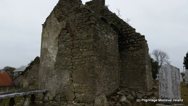
Within the historic graveyard are the ruins of a post medieval church. The structure is in poor condition and with the exception of the west gable only the foot prints of the other walls survive. The upstanding gable appears to incorporated stones from an earlier church.

Ruins of post medieval church at Lorum.
The remains of an 18th century porch with red brick in the fabric is attached to the exterior of west gable of the church.
Porch attached to west gable of Lorum Church
In 1837 Lorum church was described as ‘an old building, containing two modern tombs of the Rudkin family, has been recently repaired’ (Lewis 1837, 312). The Ordnance Survey Letters for Carlow (1837-40) recorded that at ‘
Lorum, there was, it is said, an old Church before the present Parish one, which is now falling to ruin, was erected. The spot where it stood is shown in a field, a few perches to the northeast corner of the Parish Church and a few yards to southwest corner of a Church (C of I church) which is now in progress of being built (O’Flanagan 1934, 311).
The ITA Survey of 1945 identifys the ruined church as the remains of an 18th century Church of Ireland Church and the medieval church as being located as a low-rise of ground inside the graveyard. Both churches were replaced by a seven-bay Gothic Revival Church with buttresses and parapet built c. 1838 and designed by Frederick Darley.

Church of Ireland Church at Lorum built 1838
Close to the church are the ruins of a small post medieval house which shows signs of rebuilding and alterations.

Post medieval building at Lorum
A plain granite base of a high cross provides the only physical evidence of early medieval activity at the site.

Base of high cross at Lorum
The remains of a second early medieval cross are found 200m to the west of Lorum graveyard. The cross is located on the north side of east-west running bohereen.

Bohereen leading to Lorum cross and cairn
The monument consists of a medieval cross shaft set in a cross base sitting on top of a cairn of stones and earth.
Lorum is associated with two holy wells. According to ITA Survey (1945), a well dedicated to St Laserian was located to the north the old graveyard. The well was not recorded on the 1st ed OS 6-inch map for the area but the files state it was covered by well house and located northnorthwest of the church. The farmer who owns the land the well was located on told me there was no longer a well here and he had not heard of a holy well in this location before.
A holy well dedicated to St Molaise ( the Irish for Laserian) is located to the east of the old church. The 1st ed OS 6-inch marked the well as St Molappoge’s well. The well which is now dry is stone-lined and rectangular in shape. It is covered by a large lintel stone. The well is in reasonable condition but is no longer visited by pilgrims.

St Molappoge’s holy well
St Laserian is no longer venerated in the area and all focus of the saint has moved to Old Leighlin. This is a lovely place to visit and you can see why St Laserian wanted to settle here.
References
Brindley, A. 1993. Archaeological Inventory of County Carlow. Dublin: Stationery Office.
Gwynn, A. & Hadcock, R. N. 1970. Medieval Religious Houses in Ireland. Dublin: Irish Academic Press
ITA Survey of Carlow 1945
Lewis, S. A. 1995. A topographical dictionary of Ireland:London : S. Lewis & Co
http://www.buildingsofireland.ie/niah/search.jsp?type=record&county=CW®no=10301911
O’Flanagan, Rev. M. (Compiler) 1934 Letters containing information relative to the antiquities of the County of Carlow collected during the progress of the Ordnance Survey in 1839. Bray.
–

[…] via St Laserian at Lorum Co Carlow — Pilgrimage In Medieval Ireland […]
Reblogged this on Irish history, folklore and all that.