Templecronan and the Relics of St Cronan Co Clare

Templecronan  is one of my favourite pilgrim sites.  The site is an early medieval monastic settlement dedicated to St Cronan.  It is located on farmland in Co Clare near the village of Carran. To get to the ruins you need to cross through some fields but a number of signposts guide the way.

IMG_4470

View of Temple Cronan Co Clare

Very little is known about the history of Templecronan or  the people who lived here and most of what we know about the site  is gleamed from the archaeological record.  The  site  is located  in a townland  called Termon/ An Tearmann  which means church or glebe lands.

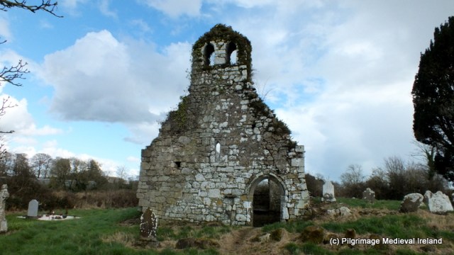
Today the most prominent feature at the site is a small rectangular shaped multi-period church. The fabric of the walls  contain traces of cyclopean masonry, a common masonry style for churches in early medieval Ireland  and  a  blocked up linteled west doorway with inclined jambs. These features, suggest an early stone church was  at the site  and was remodelled in during the  Romanesque period (1020-1170 A.D).

IMG_4475

View of the  west gable of Templecronan church

Romanesque features within the church include a round-headed  window in the east gable and corbels decorated with Hiberno-Romanesque animal heads in the west gable. There are also a number of Romanesque heads incorporated into the fabric of the walls.

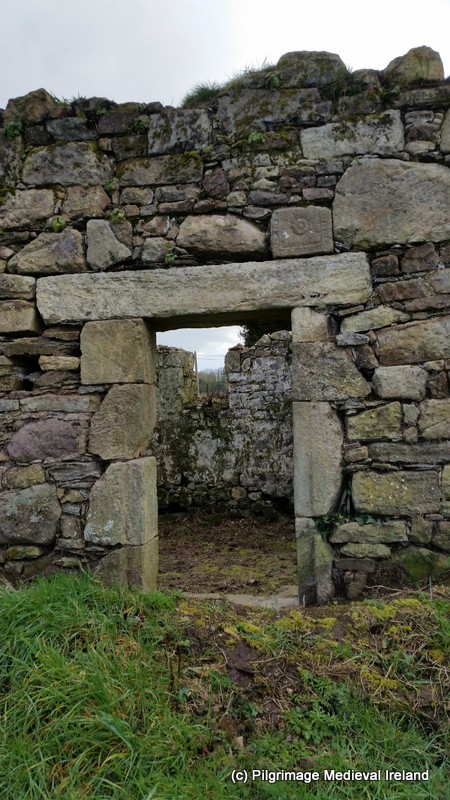
Further remodelling was carried out in the fifteenth century with the addition of a pointed  finely carved doorway in the north wall.


IMG_4477

Fifteenth century doorway in the north wall of Templecronan

Traces on an ecclesiastical enclosure can still be found in the surrounding landscape.

This slideshow requires JavaScript.

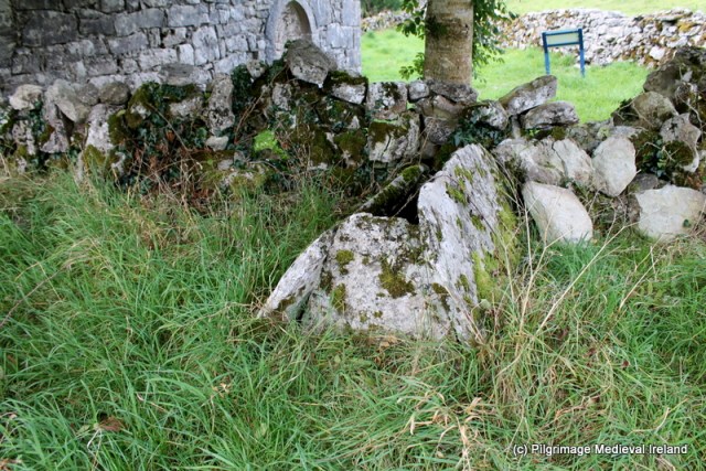
Archaeological evidence for pilgrimage at Templecronan is represented by two outdoor reliquaries located  close to the church.  Outdoor reliquaries were  built to house the relics of a saint or holy person who was normally the founder saint. Some may have been built over the original grave of the saint.  At Templecronan the reliquaries/shrines are a type known as  gable shrine. They are triangular-shaped structure made up of two long flat flag stones and two smaller triangular-shaped stones arranged like a tent and orientated east-west. The short length of the shrines suggests they were used to house disarticulated skeletons/corporeal remain (Edwards 2002, 240).

Most  scholars agree that the gable shrines are among of the earliest types of outdoor reliquary and suggest a date of seventh or eighth century.  However  Carlton Jones (2006, 138-139) suggest that both the shrines at Templecronan  were  contemporary with Romanesque carving at oratory. Only targeted excavation would answer this question definitively although excavation of a gable shrine at Illaunloughlan Island, Co. Clare  dated the shrine to  second half of the eighth century .

IMG_4499

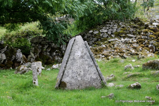
View of  gable shrine known as St Cronan’s Bed at Templecronan.

The shrine located southeast of the church is known as St Cronan’s Bed and local tradition holds this was  the burial -place of St Cronan.  The second shrine is found  northeast of the church in the adjacent field defined by modern field boundaries.

IMG_4516

Gable shrine to the northeast of the Templecronan church

The presence of the gable shrines strongly suggests that pilgrimage was taking place here as early as the eight century  and the construction of the shrines represents a period of great devotion to the saints associated with the site. The site appears to have fallen out of use in the late medieval period and devotion the the shrines gradually ceased.

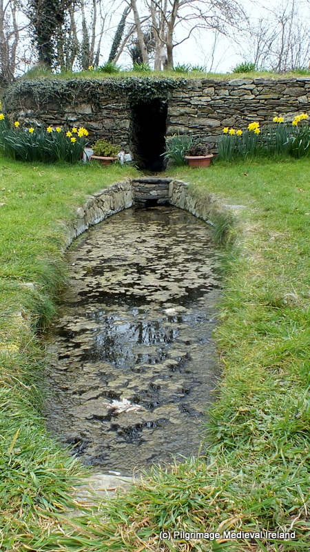
Further evidence of pilgrimage is found at a holy well located a short distance from the church. The well is  also dedicated to St Cronan and known as  St Cronan’s holy well/Tobar Chronain.

IMG_4522

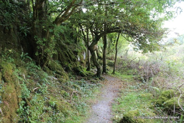
Pathway leading to St Cronan’s holy well

The holy well is  located at the base of a rock outcrop and defined by a dry-stone circular wall.

IMG_4525

Stone wall surrounding St Cronan’s holy well

The  holy well  is a simple spring. A large  penitential cairn of unknown date  is found beside the well within the enclosure. It is not possible to know if the well was part of early medieval pilgrimage at Templecronan but it was a place of pilgrimage in the nineteenth century.

This slideshow requires JavaScript.

The Ordnance Survey Letters for Clare 1839 state that ‘stations are performed but no distinct patron day is remembered‘. A quick search of nineteenth century sources has failed to turn up any further information about the well.  Today the well and its surrounding are well cared and I noticed some coins left beside a small modern religious statue which suggests it may be still visited.

Templecronan is one of many wonderful site in Co Clare and is certainly worth spending some time exploring.

References

Edwards, N. 1999. The Archaeology of Early Medieval Ireland. London: Routledge.

Jones, C. 2004. The Burren and The Aran Islands. Exploring The Archaeology. Cork: The Collins Press.

Marshall, J. & Walsh, C. 2005. Illaunloughan Island: An Early Medieval Monastery

  in County Kerry. Bray: Wordwell.

http://www.clarelibrary.ie/eolas/coclare/folklore/folklore_survey/chapter14.htm


Save

Save

Save

Save

Save

Save

Save

Save

Save

The Hidden Treasures of Co Offaly. St Manchan’s Church at Boher, Ballycumber

St Manchan’s Church

In my travels around Ireland I have found you can often find the most incredible places, relics, statues etc  in the most unlikely of settings.  St Manchan’s church at Boher, Ballycumber, Co Offaly is a great example. From the outside the church looks like any other nineteenth century  parish church found around  Ireland. There isn’t anything very out of the ordinary about the building which was constructed around  1860’s.  It has a cruciform plan and  is a functioning parish church, used every day by the local community.

13708308_10153832852807897_2267567472074064004_o

St Manchan’s church Boher Co Offaly (Thanks to Abarta Heritage for the photo http://www.abartaheritage.ie)

If you take the time to go inside the church you will find  a collection of magnificent stained glass windows by the internationally renowned  stain glass artist Harry Clarke (1889-1931), as well as  St Manchan’s shrine one of the finest surviving  examples of medieval Irish reliquaries.

St Manchan’s Shrine

It is though St Manchan’s shrine was originally constructed to house the bones of St Manchan the founder of the nearby  monastery of Lemanaghan. I have previously written about the history of the monastic site of  Lemanaghan.

St Manchan’s shrine is a twelfth-century reliquary. It is an outstanding example of early Irish decorative metal work and the work of a true master craftsman. It was commissioned by High King of Ireland, Turlough O’ Connor and likely manufactured at Clonmacnoise. The annals for 1166 state

The shrine of Manchan, of Maethail (Mohill), was covered by Ruaidhri Ua Conchobhair , and an embroidering of gold was carried over it by him, in as good a style as a relic was ever covered.

This reference likely refers to the Lemanaghan shrine  although it is possible it may refer to second shrine now lost, that existed at Mohill.  Fragments of bone possibly from the saint are still found within the shrine. From the sparse references that exist the shrine appears to have  been  housed near the high altar of St Manchan’s church at Lemanaghan  where it remained  until  the seventeenth century. It was later moved to a chapel in Boher and following the building of the parish church the shrine was moved to its current location where it remains, absent  only for a brief period following a theft in 2012.

St Manchan’s shrine is what is known as a house- shaped shrine and resembles the pitched roof of  church or oratory and it is decorated with intricate bronze work, gilt and enamel. The shrine is made of yew wood  (48cm tall by 40 cm wide by 61cm long) and is covered with highly decorated bronze figures and bosses sitting on four feet.  The bosses and decorated panels are arranged in a cruciform design on the front and back of the  shrine.

The sides or gables of the shrine are covered in elaborate filigree  and enamel work.

20160726_142413

Gable of St Manchan’s shrine

There were originally 52 figures bronze figures attached to the shrine by small bronze nails. If you look carefully you can still see the holes. The figures filled the spaces created by the cross motif on the front and back of the shrine. Only eleven figures are still attached and it has been suggested the figures may represent monks or abbots of the monastery.

20160726_140745

Bronze figures attached to St Manchan’s shrine.

The shrine was  designed to be portable  and  could be carried in processions. Four metal loops are found at each corner which allowed wooden poles to be treaded through.  A reliquary procession may have formed part for the pilgrim rituals at Lemanaghan on  the more important days in the pilgrim calendar such as the saints feast day. It is likely that the date of the translation of the saint’s relics  would also have been a special day in the pilgrim calendar.

For a detailed discussion of the shrine I recommend checking out the book Sacral Geographies  by Karen Overbey.

Harry Clarke Windows

If you follow my facebook page Pilgrimage in Medieval Ireland you will know I am a big fan of Harry Clarke’s work. Boher church  has five wonderful Harry Clarke windows.  The windows were commissioned from the Harry Clarke studio, in 1930 at a cost of £330. My favourite window depicts St Manchan the patron saint of the parish. It is clear that Clarke took inspiration from local folklore relating to the saint and from St Manchan’s shrine.

081

Harry Clarke window depicting St Manchan in the south transept.

The window depicts Manchan holding a green book above the saints head  is an image of the saint with his cow. I have written  previously about St Manchan and his cow  who was famed for her ability to produce an endless supply of milk. The cow features strongly in local folklore.

052

Harry Clarke window depicting St Manchan

Below the saint’s feet is a life-size image of St Manchan’s shrine. The window is in the south transept of the church directly behind the display location of the twelfth century St Manchan’s shrine.  Rosita Boland  sums up the visual impact of the window in article Colourful legacy of a stain glass artist

It also includes a life-sized image of the shrine, aglow with gold and bronze. When you view the actual object first and then its likeness in jewelled stained glass behind, the genius of Clarke’s commissioned work is profoundly evident. It was made for this place, to complement the shrine, and its south-facing aspect means both the window and the gilt-bronze shrine glow a luminous amber for hours.

St Manchans Shrine 13

Detailed image of St Manchan’s shrine (Thanks Abarta Heritage for the photo http://www.abartaheritage.ie for use of their image)

This slideshow requires JavaScript.

Behind the altar are three  stunning windows of the Blessed Virgin, Christ and St Joseph all depicted in rich vibrant of colours.

061

Harry Clarke windows behind the altar at Boher Church

All  the figures have angels over head.  St Joseph who was a carpenter  is depicted holding a set square in his hand while the Christ figure has the holes in his feet and hand from his crucifixion. The details of the images such as the use of colour, the fine details of the folds in robes, patterns on fabric are amazing.

Save

Save

Save


The fifth Harry Clarke window is located in the north transept and depicts  St Anne with the Blessed Virgin as a child.


079

St Anne and the Blessed Virgin as a child

This slideshow requires JavaScript.

It’s amazing to think this little church in rural Ireland  houses such treasures.  If you are visiting  Offaly I highly  recommend a visit to Boher church. It is the most inspiring  and  most wonderful place to spend time.

References  & Useful Links

Boland, R. 2011. ‘Colourful legacy of stained-glass master’. Friday 26th August The Irish Times http://www.irishtimes.com/culture/art-and-design/colourful-legacy-of-stained-glass-master-1.607027

Harbison, P. 1991. Pilgrimage in Ireland. The Monuments and the People. Syracruse University Press.

O’Brien C. 2006. Stories from a Sacred Landscape Croghan Hill to Clonmacnoise.  Mercier Press.

Overbey, K. Sacral Geographies. Saints, Shrines and Territories in Medieval Ireland. Brepols. (https://books.google.ie/books/about/Sacral_Geographies.html?id=vJeQPgAACAAJ&redir_esc=y)

http://timetravelireland.blogspot.ie/2016/02/st-manchans-shrine-boher-county-offaly.html

Holy Cow. The Miraculous Animals of the Irish Saints: Part Two St Manchan’s Cow

Medieval Pilgrimage at Lemanaghan, Co Offaly

Save

Save

Save

Save

Save

Save

Save

Save

Save

Save

Save

Save

Save

Save

Save

Save

Save

Save

Save

Save

Delighted to have made the Longlist of Littlewoods Ireland Blog Awards 2016

Im an delight to have made the longlist for this year’s Littlewoods Ireland Blog Awards. My blog  will be judged in two categories  Arts & Culture  & Education & Science.
Littlewoods Blog Awards 2016_Judging Round Button_Longlist


Save

Save

Kilmolash Church Co Waterford

Kilmolash church  is  one of my favourite  places to visit. It is located close to the Cásan na Naomh (path of the saints) an off-shoot of the ancient road from Lismore to Ardmore called  St Declan’s Road. Its roughly  about  5 or 6 miles from the historic town of Lismore,  the site of the great monastery of St Cathage/Mochuada .  Kilmolash started out its life as an early ecclesiastical site dedicated to St Molaise who was  venerated locally on the 17th of January.  There is no evidence written or physical  to suggest that the site was at any time a place of pilgrimage, although this can not be ruled out completely. The annals record that the site was plundered by Norsemen in AD 833.  In AD 912 Cormac Mac Cuileannan, bishop and vice abbot of Lismore, King of Déisi is also recorded as the abbot of Cell-Mo-Laise (Kilmolash).  Suggesting Kilmolash was in the sphere of influence of Lismore.  By the later medieval period the church had become the parish church for the parish of  Kilmolash.

Today the site consists of the ruins of a  multi-period church surrounded by a  D-shaped graveyard. The graveyard is defined by a  wooden fence and an earth and stone bank. The   modern by-road follows the curve of the graveyard.

006

Kilmolash church Co Waterford

The church  is  rectangular in shape and consists of a nave and chancel divided by a rounded chancel arch.  The nave and east wall are largely late medieval in date while the chancel walls appear to be much earlier,  possibly even 12th century in  date (O’Keeffe 2003, 171).

This slideshow requires JavaScript.

This little church has many interesting architectural features and the west wall is particularly striking with its finely carved doorway with hooded moulding and  holy water stoup.

DSCF6615

West gable of Kilmolash church

The  fabric of the building is constructed from sandstone and is in a poor state of repair and in need of some form of conservation especially the north and south walls.


A  double belfry  survives in the west gable  positioned  over an ogee-headed gallery window.

DSCF6616


The nave and chancel are divided by a chancel arch. The  arch is made of dressed stones, one of which bears  the  inscription Feare God, Honer the Kinge, Anno Dom 1635. Beneath the chancel arch is a large ogham stone. The inscription is worn but only the letters   ‘NN’ can be identified (MacAlister 1945, vol. 1, 285-6). The stone also has two  inscribed crosses located close to the ogham text. For more information on ogham stones  visit Ogham in 3D project website.

The most unusual feature at the church is rare piece of Romanesque sculpture positioned  over a flat linteled door  in  the west end of the north wall.  The carving in question is a finely carved rosette stone (Power 1898, 91; O’Keeffe 1994, 129-32).  A similar type rosette stone is found at Coole Abbey.

022

A flat lintel door in the north wall of the church. Note rosette stone over the lintel

Unfortunately the  rosette stone is not in-situ and was it was originally part of a larger composition. The carving is ‘rendered in low relief, the flower is carved onto a block of square stone and was highly stylized  within a frame of  beads‘  (O’Keeffe 2003, 171).  The stone likely dates to first part of the 12th century.
024

Rosette stone at Kilmolash church

The graveyard surrounding the church contains many fine examples of eighteenth and nineteenth century gravestones and one late medieval gravestone with a figure carved on it found on the north side of the church. Today only the head can be discerned with some difficulty. The ITA files state that the head was believed to be the head of St Molaise (ITA files).


A fragment of a font is also  found in the graveyard and likely the same as the one identified by Buckley in 1898  and found in the graveyard wall  and  kept in the church (Power 1898, 92). In 1894 Redmond recorded that ‘… a holy well exists in a field adjoining the church, but that it was covered in many years ago, and now no trace of it can be found’ (Redmond 1894-95, 155).

DSCF6647

Fragment of medieval font in the graveyard at Kilmolash

Given its roadside location Kilmolash is easy to get too and a wonderful place to pass a some time and I highly recommend a visit.

References

Buckley, M. J. C. (1896) Notes on Kilmolash Church, Near Cappoquin, Co. Waterford, WAJ vol. 2, 212-20.

Buckley, M. J. C. (1896) Notes on Kilmolash Church, Near Cappoquin, Co. Waterford, WAJ vol. 2, 212-20.
Buckley, M. J. C. (1899) Ecclesiological gleanings and jottings in Waterford and elsewhere. (continued) WAJ vol. 5, 44-8.

Macalister, R. A. S. (1945)  Corpus inscriptionum insularum Celticarum, 2 vols. Stationery Office, Dublin.

O’Keeffe, T. (1994) Lismore and Cashel: reflections on the beginnings of Romanesque architecture in Munster. JRSAI vol. 124, 118-52.

O’Keeffe, T. 2003. Architecture and Ideology In the Twelfth Century.  Dublin: Four Courts Press.
Power, Rev. P. (1898) Ancient ruined churches of Co. Waterford, WAJ vol. 4, 83-95, 195-219.

ITA Files

http://www.crsbi.ac.uk/site/2317/

http://www.libraryireland.com/topog/K/Kilmolash-Decies-Without-Drum-Waterford.php

Save

Save

Save

Cranavane Holy Well Co Carlow

Carnavane/Crann a Bhán (white tree) holy well, is located near the village of Kildavin  in Co Carlow a short distance from the Wexford/Carlow border.

DSCF6394

View of Carnavane holy well

The well has no patron but it was likely at one time dedicated to St Finian who was born at nearby Myshall.  A stone beside the lower holy well is said to bear the foot print of the saint.  Local tradition also holds that the ruins of a nearby medieval church at Barragh mark the site of a monastery was founded by St Finian.

102

Stone said to bear the mark of St Finian’s foot.

Barragh church  lies some 400 metres to the west of the holy well and is located beside an circular enclosed  historic graveyard.

061

View of Barragh holy well

Only the north and east walls of the church survives to any great height.

This slideshow requires JavaScript.

Cranavane Holy Well (s)

There are two well at Carnavane. The larger of the two  is covered by a  rectangular shaped dry-stone well house.


This slideshow requires JavaScript.

A large stone lined a coffin-shaped trough is located in front of the entrance to the lower holy well. In the nineteenth and early twentieth centuries it was a custom of bath sick or weak children in waters of the trough. There was also a tradition of dipping coffins in the trough before taking for them for  burial  in Barragh graveyard.

DSCF6404

Coffin shaped trough in front of  Cranavane holywell.

The 1839  1st OS 6-inch’ map shows a building,  farm-yard and gardens located  beside the wells. The  footprints of the building and  associated garden walls  and lane way still remain.   The second  holy well  is located a few meters behind the lower well it is also covered with a dry stone well house of a simpler construction.

DSCF6419

The second holy well behind the main holy well at Carnavane

O’Donovan in the Ordnance Survey Letters records that a ‘patron’ or pattern day  was held here until the year  1798 , on the 3rd of May when it was then banned by the authorities (OSL 1839, 119).  He noted that pilgrims continued  to visit the well for cures of sore eyes and limbs in 1839.   There seems to have been a revival of pattern in the early 1800’s but the event was banned again in the 1870’s by the parish priest due to faction fighting.

Pilgrimage continued at a local level  to the well but over time the traditional prayers and rounds were forgotten.  Up until the twentieth century many people from the townland  would visit the well each Sunday during the month of May and the rosary was usually recited.

By the late 1990s the  holy wells  had  become over grown and the local community cleaned away the scrub and landscaped the site.  The wells were kept as they were and a stone cairn  which may have been a pilgrim station, was rebuilt.  In the early 2000’s a community mass began to be held at the well during the month of May. The mass is often held on the 3rd of May but this is  date is not strictly adhered to.

20160322_134839

Stone cairn rebuilt by local community during restoration works at Cranavane

People from the area surrounding the well still visit here during the month of May and it is also a popular tourist attraction throughout the rest of the year.

086

Mass at Cranavan holy well on 11th of May 2016.


Cranavane is  a great place to visit  for anyone seeking peace and tranquillity and it is also on the Carlow trail of the saints.


Save

Save

Save

Save

Save

Save

The Pilgrim sites of Myshall Co Carlow

Carlow is a wonderful county full of amazing archaeology  and historic sites.  I recently visited the village of  Myshall  located at the foothills of the Blackstairs Mountains a short distance from the Carlow/Wexford Border. Myshall is  traditionally held to be the birthplace of the great Irish saint St Finian, founder of the celebrated monastery of Clonard in Co. Meath.  An early medieval church dedicated to the saint sits at the centre of the  village.

DSCF6376

St Finian’s  church at Myshall

The church now in ruins is a pre-Norman  structure and only the west gable of the church survives to any great height. Within this wall is a very fine semicircular arch doorway.

The site is also associated with St Brigit. A short distance from the church is  two-basin bullaun stone known as St Brigit’s Stone.

DSCF6382

Bullaun stone at Myshall

Local folklore  connects this stone to a series of parallel ridges called the ‘Witch Slide’ on the nearby Blackstairs Mountains.

1024px-Blackstairs3

Blackstairs Mountain overlooking Ballymurphy, County Carlow. By Sarah777 (Own work) [Public domain], via Wikimedia Commons.

It was said that a Carlow witch had a falling out with her neighbour in Co Wexford and she decided to throw a stone at her. As she began to throw the stone she slipped and fell creating the ridges.  A standing stone in the townland of Clonee was said to be the stone she was trying to throw. It was said the  marks of her knees where she  landed were preserved in the bullaun stone at Myshall.

This slideshow requires JavaScript.

Outside the graveyard circa 18m from the church is a holy well dedicated to St Brigit. The  well is now dry and its structure has been incorporated into a modern grotto. Both the well and grotto are dedicated to St Brigit.  The Ordnance Survey Letters for Co Carlow state that a  pattern was held here annually on the 14th of September the feast of the exultation of the Holy Cross, the Titular feast of Myshall. The pattern day coincided with the Myshall Sheep fair which was held in the village up to the 1960’s. By the 1930’s  all memory of the traditions of stations or cures had been lost (O’Toole 1933, 13).

DSCF6369

St Brigid’s holy well at Myshall

According to O’Toole writing in 1933,  the spring from which the well was supplied came from the graveyard and the spring water flowed from here through a drain under the boundary wall. Three stone steps lead down to the well, and there was a large opening for the overflow.

A few yards from the well there is a large flag set obliquely in the ground; in the centre of this flag there is a round aperture, which apparently was meant to let water pass through while at the same time, acting as a dam (O’Toole 1933, 13).

The area around the well has undergone some landscaping and it is now a feature of an amenity park which incorporates a large pond and water wheel.


DSCF6368

Shrine and holy well at Myshall

References

O’Toole, E. 1933. The Holy Wells of County Béaloideas, Iml. 4, Uimh 1 pp. 3-23

Ordnance Survey Letters for Co Carlow. http://www.askaboutireland.ie/reading-room/digital-book-collection/digital-books-by-subject/ordnance-survey-of-irelan/

Save

Save

Save

Save

St David’s well Olygate

St David’s well is located a short distance from the  village of Olygate in the townland of Ballynaslaney. The well is one of the most popular pilgrim sites in the Co Wexford. People come throughout the year to pray here with the main burst of  devotions are carried out on the saints feast day the 1st of March.

St. David’s Well is a natural spring defined by a key hole shaped wall and a  series of  steps lead down to the well’s waters.

St David's well Olygate

St David’s well Olygate

The stream from the well flows west  into a small concrete bathhouse.

St Davids well (1 of 1)-2

Bath house at St David’s well

The well  and church are marked as St David’s well and church on the  1st edition Ordnance survey map (1840) . The church was the  medieval parish church of Ballynaslaney parish, it was located to the east of the well within a modern raised rectangular graveyard  defined by scarps. All traces of the building above ground are gone but the doorway from this church is said to have been built into the church at Suanderscourt (Lewis 1837, Vol. 2, 198).

The  Ordnance Survey Letters of  Co Wexford tell us that by the 1840’s the well had been stopped up by the farmer who owned the  land it was  on.  The Letter’s  described the well  as ‘…enclosed by a turry and its door locked’.  They go on to say in the past the water was ‘sold for a cure of disease’ until around 1810  when it was stopped up by the aforementioned farmer.  The Letter’s also record that the  well was formerly associated with ‘a pattern day held annually in honour of the saint  on the last day of March which is still a holiday in the parish’. This would mean the pattern was held on the 31st of March but it is likely this mistake on the part of the writer and 1st of March was the true date.

At some point the well was opened again and by 1910 Grattan Flooded noted the old pilgrimage had been revived and the current wall surrounding the well was erected.  The popularity of the pilgrimage is indicated by an add in the  Irish Independent September 19th 1910  that noted a car service will to ferry pilgrims from Enniscorthy railway station to the well and back for a fee of 1s. 6d.

add st davids well

Advert Irish Independent 19th Sept 1910 ( Irish Newspaper Archive).

A spat of cures were recorded between 1911-1913 at the well increasing the sites popularity and fame.

Picture1

St David’s well at Olygate Rober French Collection NLI  http://catalogue.nli.ie/Record/vtls000043751

The pilgrimage was again in decline by 1916 but it managed to weather the storm and devotion has continued and grown over the years. The 1st of March is by far the busiest time of the year for pilgrims in modern times. Many people still have great faith in the healing qualities of the water.

This slideshow requires JavaScript.

References

Flood, W. H. G. 1916. The History of the Diocese of Ferns. Waterford: Downey and Co.

O’Flannagan, M. 1933. Letters containing information relative to the antiquities of County of Wexford :collected during the progress of the Ordnance Survey in 1840. Typescript.


Save

Save

Save

The Birthplace of St Colmcille

Tradition holds St Colmcille was born at  Gartan in Co Donegal. The exact location of the saints birthplace is open to discussion. One tradition says the saint was born on a stone called the Leac na Cumha in the townland of Lacknacoo.

Leac na Cumha or the Stone of Sorrow is stone set into a large  oval-shaped mound with a U-shaped setting of stones that opens to the north.

20160316_120036

Leac na Cumha in Lacknacoo

The Leac na Cumha is located along th south-eastern edge of the mound. It is a flat slab of stone and its surface is covered in prehistoric rock art. The art  consists of cup-marks c. 0.1m in diameter.

DSCF6069

Leac na Cumha is covered in rock art

It is here on this stone that the saint is said to have been born.  The site was marked on the 1st ed. (1836) OS 6-inch map as St Colmcille’s stones. Close to the mound is an enormous stone cross erected by Cornelia Adair in 1911.

DSCF6078

Stone cross at Leac na Cumha in Lacknacoo

In the nineteenth century

it became commonplace for emigrants to spend their last night here on the Leac na Cumhadh – the Stone of Sorrows. As Colmcille had decided to exile himself to Scotland, they thought that sleeping here – where he was born – would make their sadness easier to bear (http://www.colmcille.org/gartan)


A short distance away are the ruins of an early medieval ecclesiastical site at Churchtown – Ráth Cnó . Tradition holds this was the  place where St Colmcille’s family lived.  It was said his family gave this land  to the church so that a monastic settlement could be built here. The site over looks  Lough Akibbon and Lough Gartan.

The site is still used as a turas by pilgrims who walk barefoot between the five marked stations. Believers follow the turas between Colmcille’s feast day on 9th June and the end of the turas season on 15th August, performing a series of prayers and actions at each stop (http://www.colmcille.org/gartan/3-03).

The most prominent features on the site is a small church marked as St Colmcille’s chapel on the 1st ed (1836) OS 6-inch map.

DSCF6083

Medieval church at Gartan

According to the Donegal Archaeological Inventory this is probably the chapel described in 1622 as being in repair and having a thatched roof.

To the north of the church is a graveyard, at the  centre of which  are the foundations of a building  said to be a monastic building.

DSCF6123

Possible foundations of a monastic building

Two stone crosses also survive at the site and are part of the pilgrim stations.


Below the site is a holy well dedicated to the saint.

DSCF6113 (1)

St Colmcille’s holy well at Gartan


Both of these sites are part of the Slí Cholmcille  and directions can be found on this website.

Useful Links

http://www.colmcille.org/gartan/3-03

http://www.colmcille.org/gartan/3-02

The Eastern Pilgrim Route to Mount Brandon

Mount Brandon is one of the great pilgrim sites of medieval and early modern Munster. It has a long history of pilgrimage stretching back to pre-historic times.  The traditional times of pilgrimage were May 16th the feast of St Brendan, Lá tSin Seáin Beag (June 29th) and the last Sunday in July known locally as Domhnach Chrom Dubh. Over the years the  pilgrimage has had its  ups and downs but it still continues today.

1024px-Mount_Brandon

Mount Brandon image by Ingo Mehling (Own work) [CC BY-SA 3.0 (http://creativecommons.org/licenses/by-sa/3.0) or GFDL (http://www.gnu.org/copyleft/fdl.html)%5D, via Wikimedia Commons.

There are a number of approach routes used by pilgrims to the summit. The western approach is known as the Saint’s road and links  the area around Ventry Harbour to the summit.

A second pilgrim route approaches  Mount Brandon from the east. This route stretching from the village of Cloghane to the summit of Mount Brandon. It is a more physically demanding route then the Saints’ road and takes the pilgrim on the way to the summit through the most scenic of locations including a glaciated valley.

I have just created a StoryMap of the eastern approach to Mount Brandon which I hope you will enjoy.

cloghane

Story Map of the eastern pilgrimage route to Mount Brandon

This slideshow requires JavaScript.

Anyone interested in the western approach route known as the Saint’s road  should see my blog post on the Saint’s road.

Pilgrimage at Kilgeever Church and Holy Well Co Mayo

Last year I was delighted to write a  guest blog post about of  the pilgrim site of Kilgeever in Co Mayo. This post was a guest blog for the very informative heritage blog The Standing Stone.ie. This is a great blog and worth checking out as it has lots of varied and interesting content. At the moment I am working  on some research concerning this area of Mayo and as the site is fresh in my mind  I have decided to repost my guest post.

Pilgrimage at Kilgeever Co Mayo.  Originally posted on the Standing Stone Blog

Kilgeever/Cill Ghaobhair is located in the most scenic of setting on the slopes of Kinknock around 3km outside of Louisburg in Co Mayo. The site is part of the Clew Bay Archaeological Trail.

Fig 1

View of the medieval church at Kilgeever from the small laneway that leads to the site.

Local folklore holds that St Patrick came to Kilgeever having completed his fast of forty days and nights on the summit of Croagh Patrick. It is said that Patrick decided to build a church here and that he later sent St Iomhair one of his disciples completed the task. Some traditions would suggest that “Kilgeever” is the anglicised version of “Cill Iomhair” or the church of Iomhair. The Ordnance Survey Letters of 1838 translates the name as St. Geever’s Church.  Curiously neither variants of the saint’s name are found in Ó’Riain’s Dictionary of Irish Saints.

Alternatively the name may derive from Cill gaobhar, ‘the near Church’ (Corlett 2001, 130) or as the Schools’ Manuscripts Essays  for Louisburg(1937/38) state

Kilgeever- according to the interpretation of most people means “the windy church”.

Fig.2

View of Kilgeever Church and graveyard.

Almost nothing is known about the history of the site but it appears to have functioned as a parish church in the late medieval period. Today the site consists of the ruins of a multi-period medieval church surrounded by a historic graveyard, a holy well and penitential stations. At least three early medieval cross slabs are associated with the site suggesting some sort of early medieval activity. If there was an early medieval monastic settlement here as the name ‘abbey’ would imply no physical remains survive above ground.

Traditionally pilgrims visited here on the 15th of July the Feast of the Apostles and on Sundays.  The Ordnance Survey Letters of 1838 refer to a pattern formerly held on the 15th of July. There was also a tradition of visiting the site on the last Sunday of July. For some pilgrims it is a key component of their pilgrimage to Croagh Patrick and having completed their pilgrimage on the summit of Croagh Patrick they descend the mountain and end their pilgrimage at Kilgeever.  The ITA Files 1944 also makes reference to pilgrims visiting here from the 15th of August to the 8th of September with the annual pilgrimage day being the 15th of August.

Fig.3

Holy well at Kilgeever

The main focus of devotion at Kilgeever is a small holy well located in the northwest corner of the historic graveyard that surrounds the medieval church.

The Ordnance Survey Letters of 1838 state

It is a good spring and much frequented by pilgrims especially for Sundays and on the 15th of July when a pattern is held, now at Louis Borough but which was formally held at the this well.

The traditional pilgrim stations begin at this holy well, located just inside the entrance to the historic graveyard. The well is known locally as “Tobar Rí an Dhomhnaigh” or “Our Lord’s Well of the Sabbath” and the 1st ed. (1839) Ordnance Survey Map record the name of the well as Toberreendoney (Anglicisation of the former).

The Pilgrim Rounds

The pilgrimage begins with the pilgrim walking clockwise around the well forming his/her intentions. The pilgrim then kneels at the well and recites 7 Our Fathers (Paters) & 7 Hail Mary’s (Aves) and the Creed.

Fig. 4

Holy well Kilgeever

The pilgrim stands and circles the well 7 times while reciting 7 Our Fathers, 7 Hail Marys and the Creed.  Once the perambulation is completed, the pilgrim kneels again at the well and recites 7 Our Fathers, 7 Hail Marys and the Creed. It was not uncommon for pilgrims to pick up 7 stones from the well as an aid to counting the rounds dropping one stone as each circuit of the well was completed.  The use of stones to count prayers is a common practice at Irish many Irish pilgrim sites especially those with complex prayer rituals.

The pilgrim then walks to the three flagstones located to the south of the well where he/she recites 5 Our Fathers, 5 Hail Marys and the creed while kneeling.

The pilgrim then proceeds to a small rock outcrop known as St Patrick’s rock where he/she kneels and rites 3 Our Fathers, 3 Hail Marys and the Creed. This stone is reputed to bear the tracks of St Patrick’s Knees (ITA Files). In modern times some pilgrims have inscribed crosses on this rocks and others around where the stations are performed.

Fig.5

St Patrick’s Rock

The pilgrim then walks to and enters the medieval church at the centre of the graveyard.

Fig.6

Kilgeever church is a multi-period church with a fifteenth doorway.

Within the interior of the church the pilgrim kneels and again recites 7 Our Fathers, 7 Hail Marys and the creed and pray for the souls of the dead.  In the 1940s it was common for pilgrims to leaving the church following along the west wall (ITA Files).

Fig.7

Pilgrim cross carved by modern pilgrims on 19th century graveslab within Kilgeever Church.

Some pilgrims continue a modern practice of scratching a cross into a late 19th century graveslab belonging to  the Mac Evilly family. When I visited the site in 2014, a number of  tiny stones were left on the edge of the slab. Other accounts suggest that in the mid-twentieth century pilgrims were in the habit of leaving votive offering in the aumbry within the church. This tradition was not noticed on my visit but a number of religious objects were left at the well.

Fig.8

Some votive offerings left at the Kilgeever Holy Well

Having left the church the pilgrim walks back to the well via a stream that runs the length of the western side of the graveyard.  If the pilgrim’s stations are being performed on behalf of a living person the pilgrim is to walk in the waters of the stream to the well. If the pilgrimage is being performed for the dead, the pilgrim walks along the edge of the stream.

Fig.10

Stream running along the western side of the site.

The pilgrimage is completed when the pilgrim circles the well a further 3 times prayer in honour of the Blessed Trinity. Before leaving the Holy Well pilgrims  are invited to pray for Henry Murphy of Castlebar who had the cross erected over the well (as indicated by an inscription on the cross).

A photo dating to the 1890s and part to the Wynne Collection at Mayo County Library shows pilgrims kneeling in prayer at the holy well in bare feet. This photo confirms what was a common practice at the time for people to complete such pilgrimages barefoot and even today at a small number of pilgrim sites pilgrims continue this practice.  The photo also shows that the well has changed little over the years with the exception of the  addition of the  cross which now surmounts it.

Fig.11

Early Medieval Cross Slab with an outline Greek cross found at Kilgeever. This is one of three cross slabs from the site.

Kilgeever is one of the most peaceful and tranquil places  to visit and it is just one of many interesting sites around Clew Bay area.

Fig.9

View of the east gable of Kilgeever church.

References

Corlett, C. 2001. Antiquities of west Mayo: The Archaeology of the Baronies of Burrishoole and Murrish. Bray: Wordwell.

Higgins & Gibbons 1993: J.G. Higgins & Michael Gibbons. ‘Early Christian monuments at Kilgeever, Co Mayo’. Cathair na Mart, 13, 32–44.

Irish Tourist Association Files for Mayo 1944.

The Schools Collection, Louisburgh (roll number 5128/9), Volume 0137, Page 005, 006,  026, 027 (http://www.duchas.ie/en/cbes/4428011/4368055)

http://www.louisburgh-killeenheritage.org/page_id__85.aspx

http://www.logainm.ie/en/37369

http://www.thestandingstone.ie