Medieval Pilgrimage at Lemanaghan, Co Offaly

The ecclesiastical settlement of Lemanaghan is one of Co. Offaly’s hidden treasures. There  is so much to say about the architectural remains and the history of the site  and of course its founding saint, Manchan.   I am going to  focus on the evidence for medieval pilgrimage at the site .

In early medieval times  Lemanaghan was  located  in the territory of the Delhna Ehtra tribe close to the border of the territory of the Delbna Ethra  and the Ferceall.   For the modern traveler it is located along the R436   to the east of the town of Ferbane.

Map of Lemanghan showing  the monastic remains from Bing maps

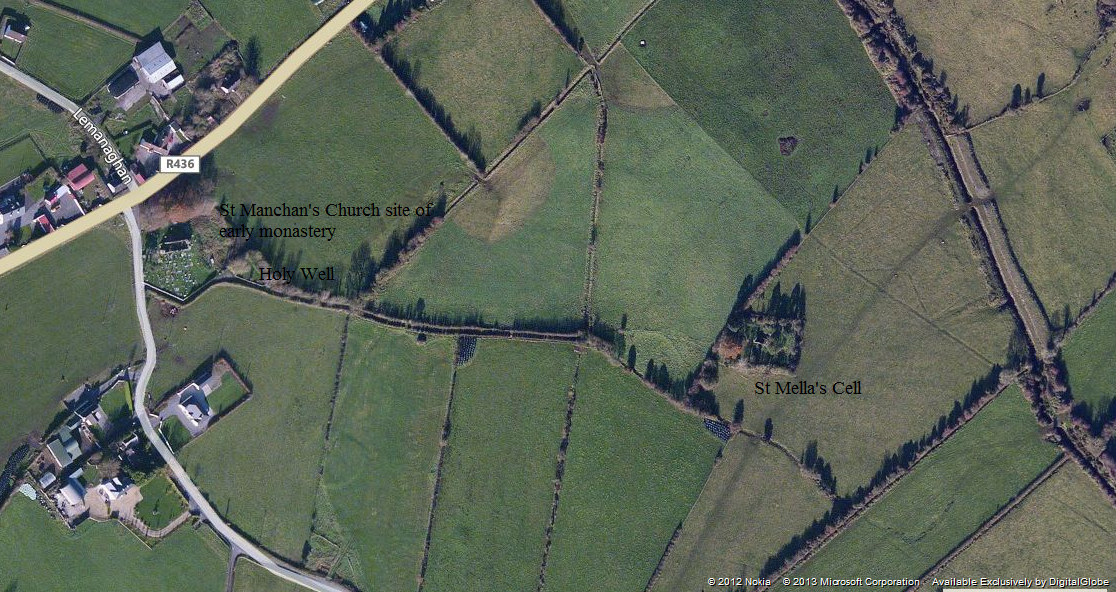
Map of the ecclesiastical remains a t Lemanghan from Bing maps (http://www.bing.com/maps/)

Lemanaghan was founded in the 7th century after King Diarmaid   son of Aedh Sláine, granted the land of the territory of Tuaim-nEirc (Doimerc) to Clonmacnoise following his victory at the battle against Guaire King of Connaught in 645/646.  It appears  that Manchan a monk of Clonmacnoise, founded a sister monastery  here  at Liath-Manchain  ” the grey place of Manchan” (Lemanaghan is the anglicized version ). There are a number of traditions  concerning the geneology St Manchan.  One tradition  suggests he was a member of the Ulaidh of Ulster while another suggest he a was a member of the Eoghanachta of Munster and another that he  was from Wales.  The saint was credited with writing many poems during his lifetime .  Manchan is also associated with the Mohill in Co Leitrim where local tradition holds he  founded a monastery here before heading to Lemanaghan. Manchan died in 664/665  having caught the yellow plague that raged through the country. This is the same plague which killed St Féichín of Fore.

RIMG1613

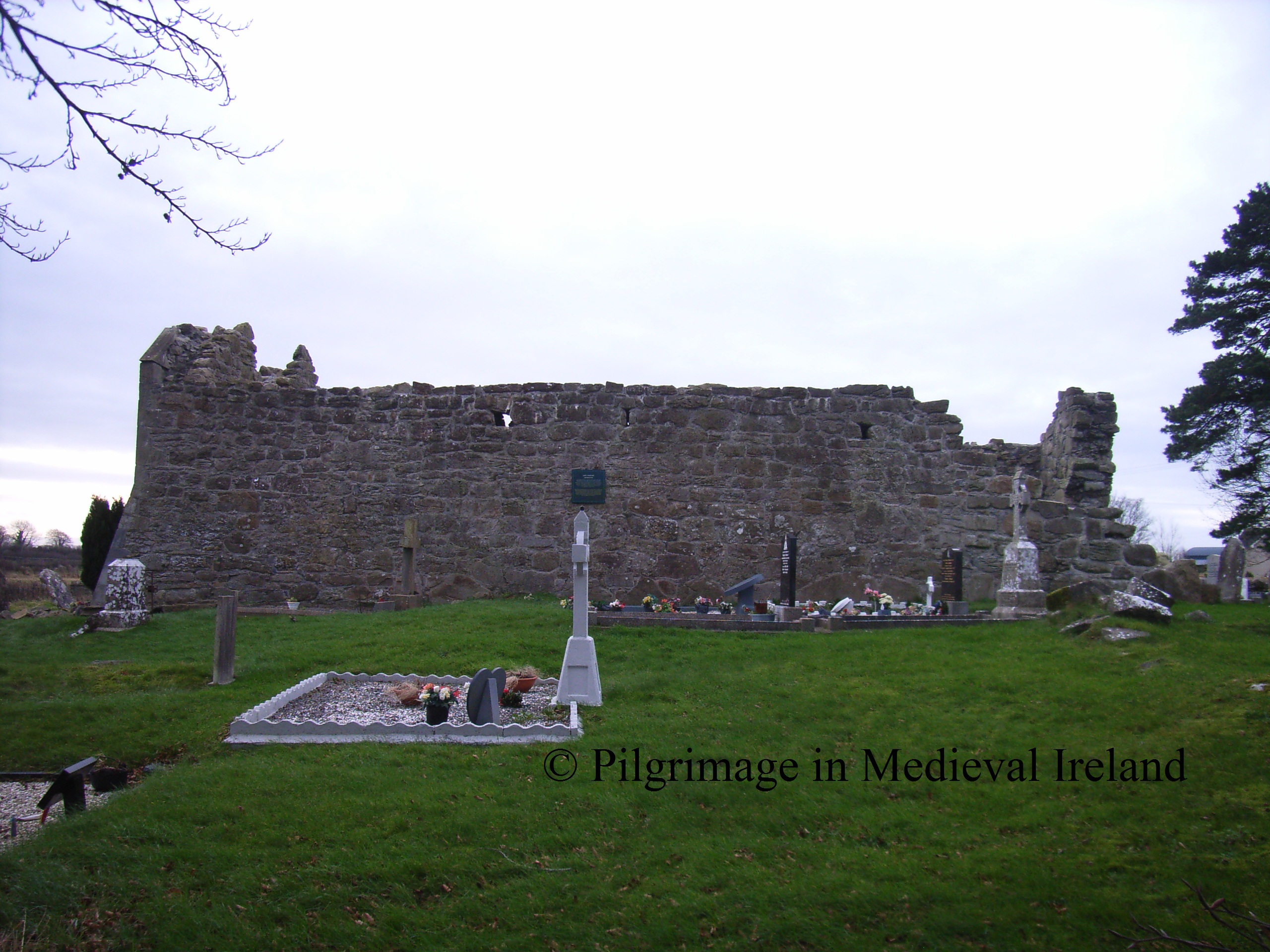
St Manchan’s church at Lemanaghan

The modern landscape of green fields that surround Lemanaghan  would not  have been the lanscape encountered by  early and later medieval travelers & pilgrim’s.  The modern landscape surrounding Lemanaghan  is  a product of  modern intensive peat cutting.   Originally the monastery  was  founded on a  natural island of dry ground surrounded by  raised bogs. Monahan writing in 1863 describes the site as follows;

Standing on a low swell, an armlet of well-reclaimed bog, it gently rises above the extensive moors with which it is almost surrounded.

This doesn’t mean the Lemanaghan was isolated  from the rest of the world. It was linked  to other settlements in the area in particular Clonmacnoise , and the wider world  through a series of bog roads and tracks . Excavations carried out in the surrounding landscape have identified several roads and tracks many  dating to the 6th and 7th centuries when the monastery was founded.  The excavations also show that roads and tracks were being built and repaired around Lemanaghan up to the 17th century, suggesting it was a focal point in the landscape throughout the medieval period.  Thus its location was not a barrier to pilgrims and visitors.

Little physical evidence remains of the early monastery with the exception of a number of early medieval cross slabs ( two of which are found with St Manchan’s church and ten others housed in national school), a large  bullaun stone (beside the holy well) and a holy well dedicated to St Manchan.  The   annals  list the names of several abbots of the monastery ( in the years  717, 767, 792, 853, 893, 1205). The fortunes of the monastery declined in the later medieval period.  By 1302-6  Lemanaghan became a parochial church.  The papal taxation records,  record that there were no returns from the vicarage of Lemanaghan as it had been ‘laid to waste by the ravages of war’.  St Manchan’s Church  continued in use probably until 17th century and  by 1682-5, the church was recorded as being in a ruinous condition, with church services being held in a nearby house.

RIMG1615

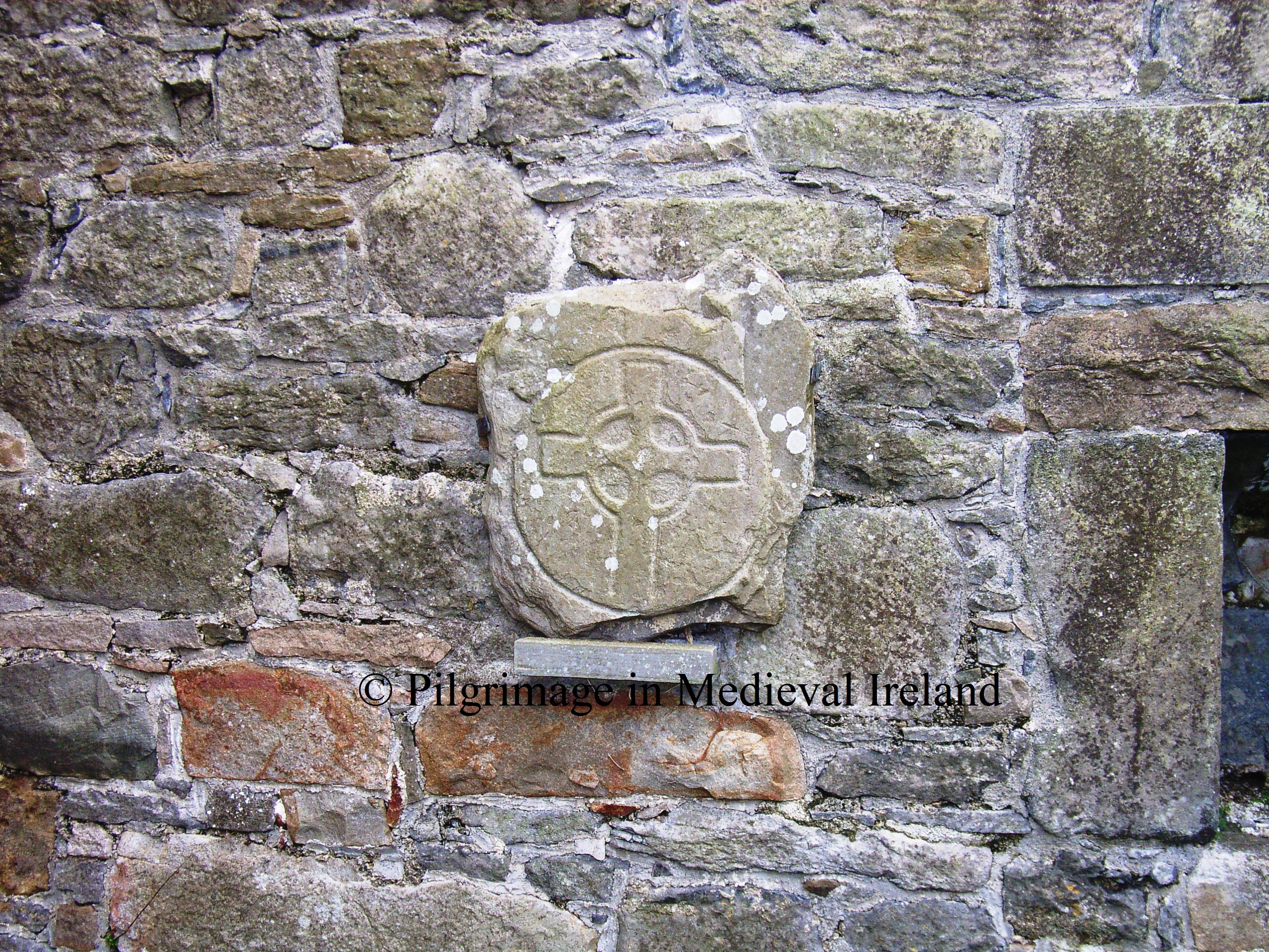
Early medieval cross slab within St Manchan’s church

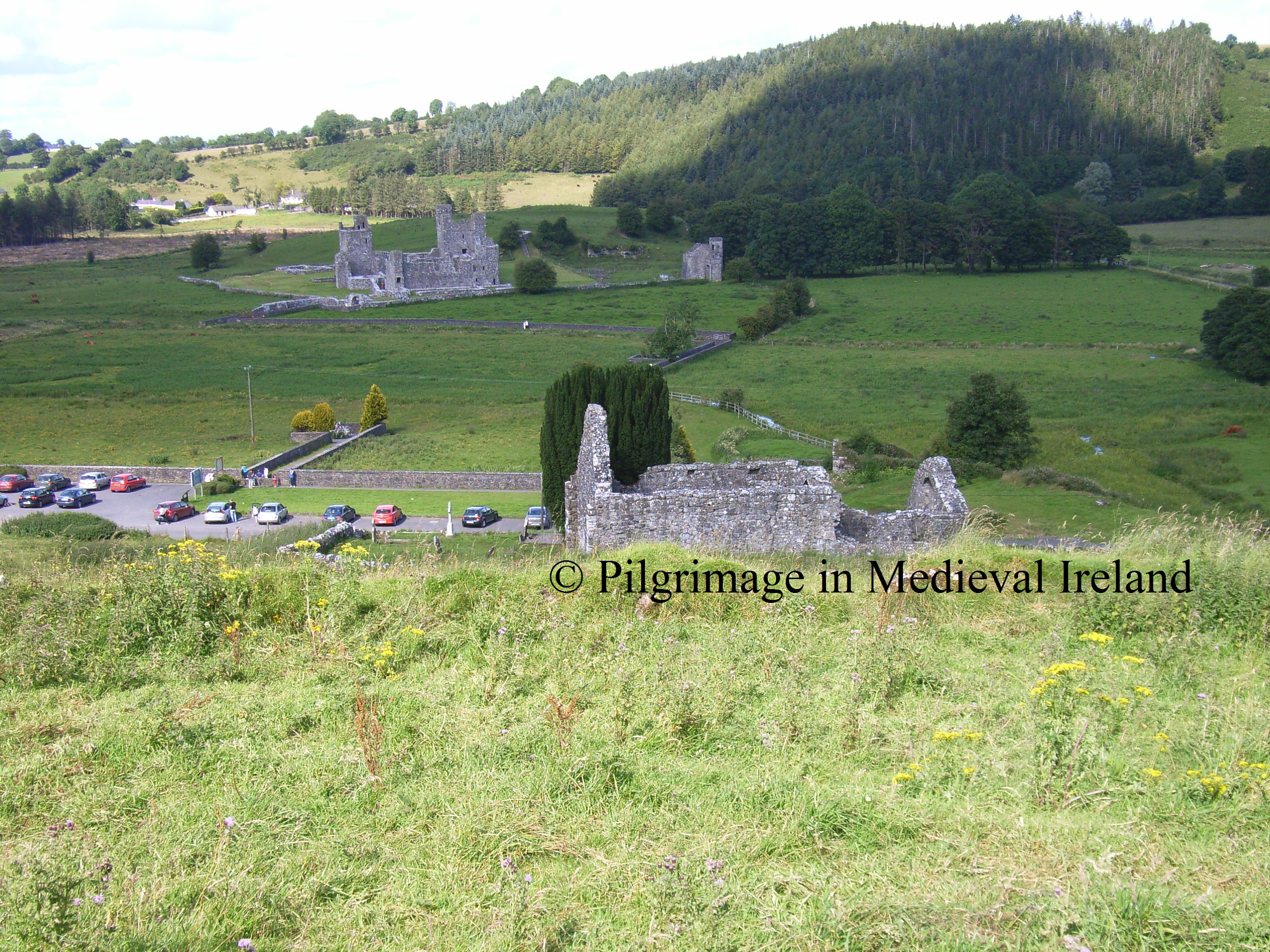
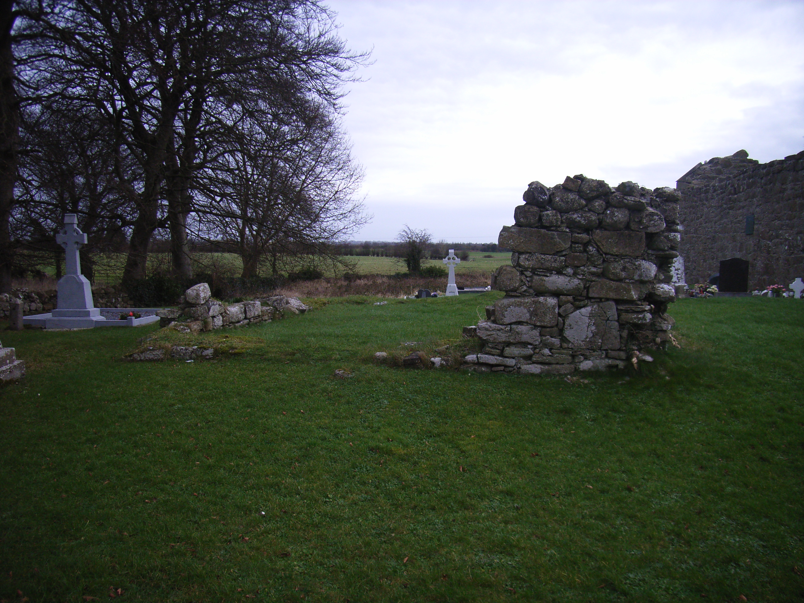
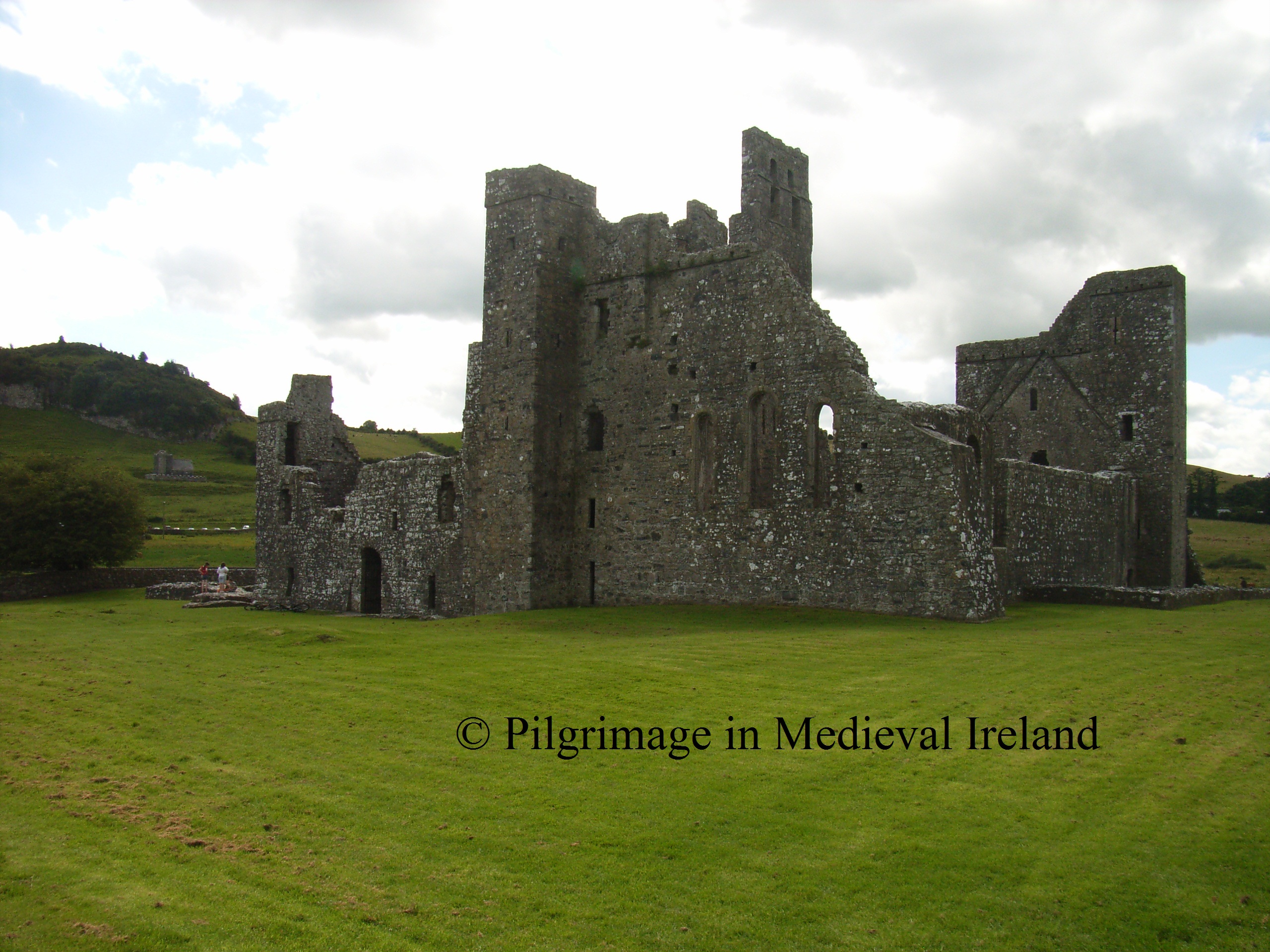
The main monastic complex  was located at the site of   the modern graveyard. All that  remains  today of this once vibrant monastery  are  two structures called St Manchan’s church and St Manchan’s house.

St Manchan’s church  was built-in  two phases, the  west end dates to the 12th century.  Further building work was carried out in the 15th century at the eastern end .  The  western end of the building  is the oldest with  traces large limestone blocks in its  lower walls and a large Romanesque doorway of 12th century date marks the  entrance in west gable.  A  round-headed Romanesque window also survives.

RIMG1627

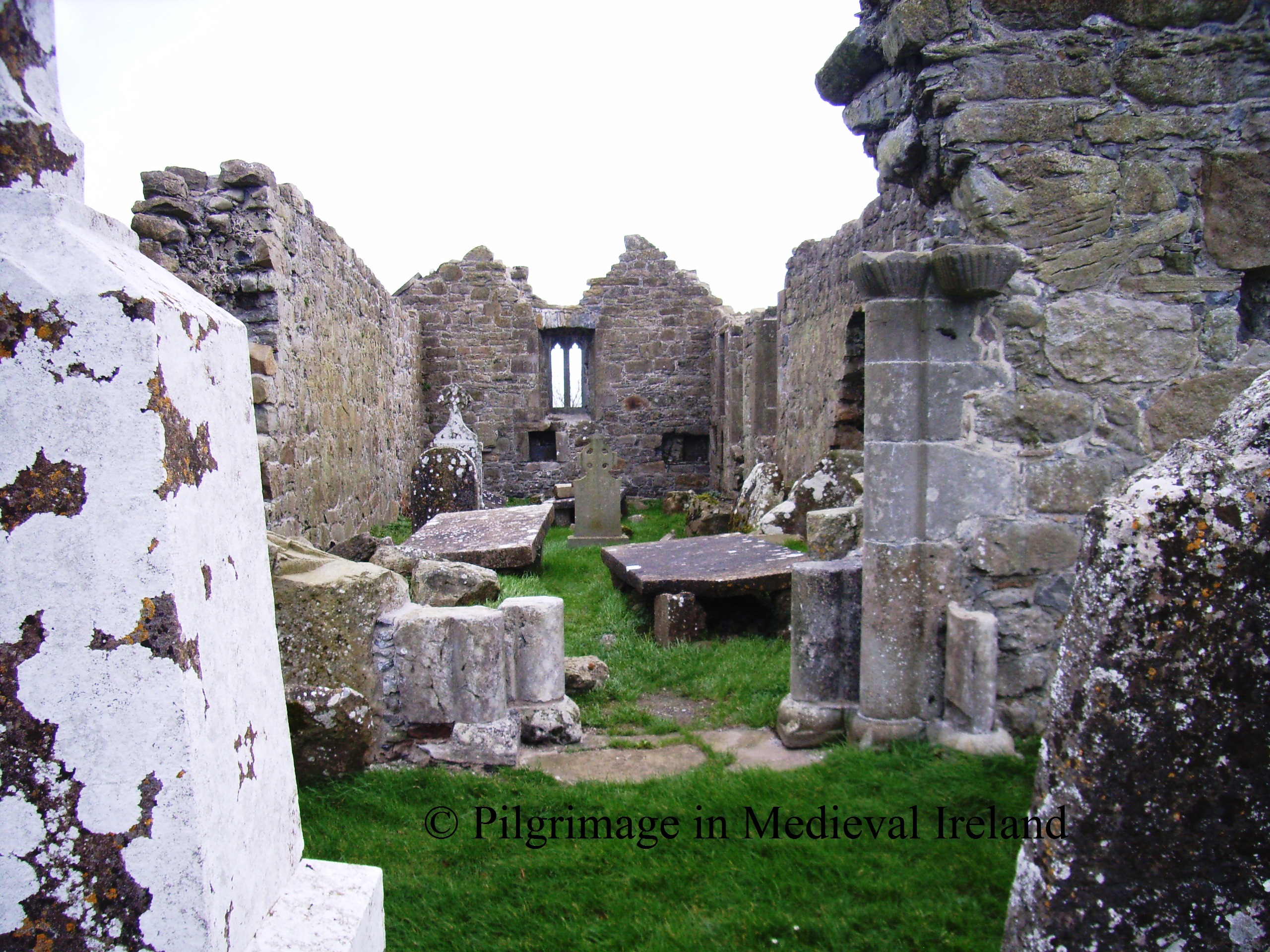
Romanesque doorway at St Manchan’s church

Little remains of the second structure called St Manchan’ house, with  only the foot prints of the foundations   visible, the Archaeological Inventory of County Offaly suggest that it is  likely contemporary with the 15th century section of St Manchan’s church.

St Manchan's house

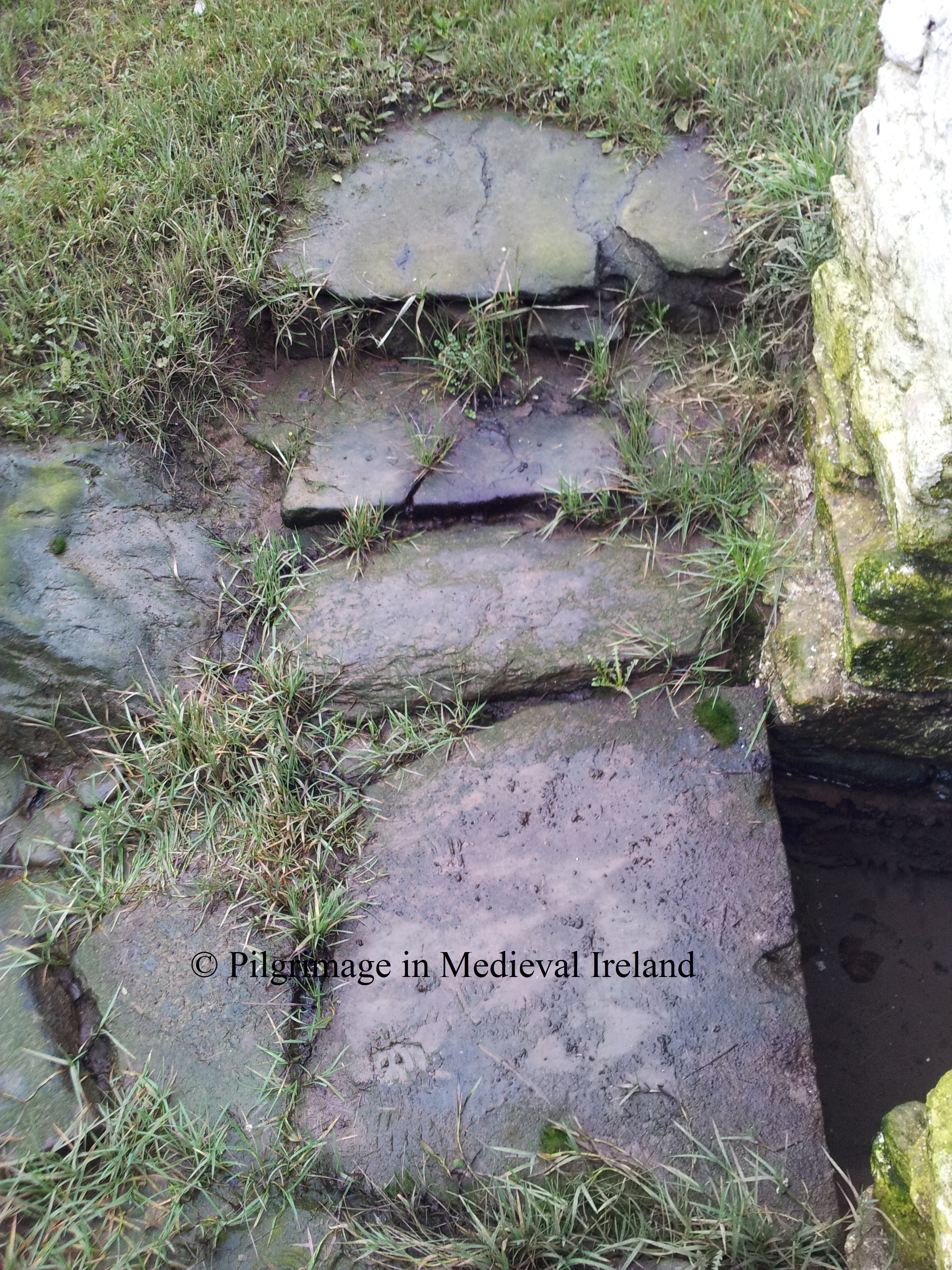
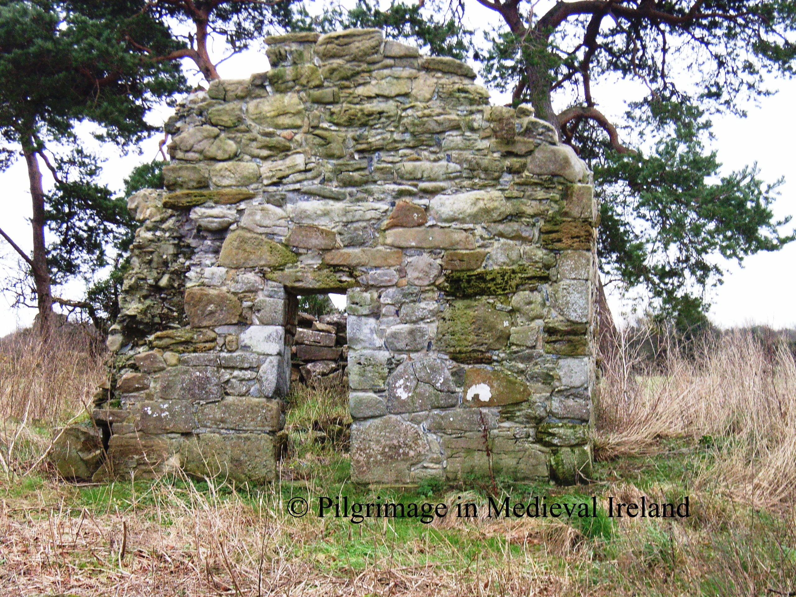
A third church  known as St Mella’s cell,  is located  approximately 350m to the  east.  The site is connected to the main monastic centre  by a narrow paved causeway. Local folklore recounts  that  depressions visible   in the surface of the paving stones of the causeway were  caused by  the saints cow.  St Mella was Manchan’s mother and  tradition suggest she  live here as an anchorite. The present church may have been built on the original cell.

RIMG1636

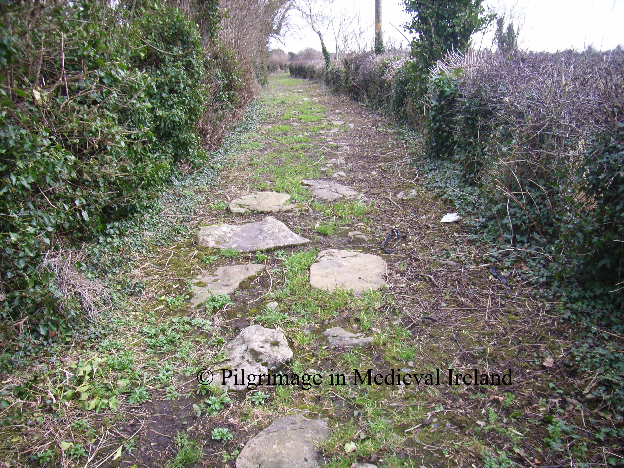
Causeway leading to St Mella’s Cell

St Mella’s cell  is quiet small measuring  5.5m x 3.1m internally. The walls are  0.8m thick  and constructed  of large  what look like really large cut stones.  These stones are in fact thin slabs set on edge  in the manner of facing stones and the core of the wall is filled with stone rubble. This type of building technique is common in pre-Norman Irish church building.  The church is surrounded by  its original rectangular-shaped enclosure (43m E-W by 35.5m north-south).

RIMG1646

Evidence for Pilgrimage

So what can we say about pilgrimage at Lemanaghan in medieval times?  Pilgrims came here to venerate St Manchan and the anniversary of  the saints  death on the 24th of January would have had a special appeal for pilgrims.  Pilgrims  probably  first began coming here following Manchan’s death.  Given Lemanaghan   proximity and close connections to Clonmacnoise,  the site likely attracted pilgrims heading to Clonmacnoise and to other sites such as Durrow and Rahan, acting as a secondary shrine.  Manchan was probably buried here we have no way of knowing if the saints grave had an appeal for pilgrims.  From the 12th century  onwards  a reliquary known as St Manchan shrine   would also have attracted pilgrims.
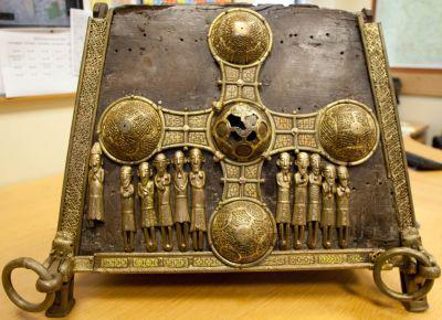
The shrine was   commissioned by High King of Ireland, Turlough O’ Connor and  was reputed to house the bones of St Manchan  and manufactured at Clonmacnoise. The annals for 1166 state

The shrine of Manchan, of Maethail (Mohill), was covered by Ruaidhri Ua Conchobhair , and an embroidering of gold was carried over it by him, in as good a style as a relic was ever covered.

This reference likely refers to the Lemanaghan shrine  although it is possible it may refer to second shrine now lost, that existed at Mohill.  Fragments of bone possibly from the saint were found within the shrine.  From the sparse references that exist the shrine appears to have  been  housed near the high alter of St Manchan’s church untill  as late as  the 17th century. It was later moved to the parish church at Boher where it remained until it was stolen last year. Thankfully the shrine was recovered the next day. St Manchan’s shrine is one of the finest  medieval reliquaries to survive in Ireland and its loss would have been significant.

St Manchan’s shrine is what is known as a   house- shaped shrine and resembles the pitched roof of  church or oratory. The shrine  is made of yew wood ( 48cm tall by 40 cm wide by 61cm long) and decorated with highly decorated bronze figures and bosses and  sits on four feet. The shrine was portable  which meant it could be  carried in processions. Four metal loops are found at each corner which allowed wooden poles to be treaded through.  A reliquary procession may have formed part for the pilgrim rituals on  the more important days in the pilgrim calendar such as the saints feast day. It likely that the date of the translation of the saints relics to the shrine would also have been a special day in the pilgrim calendar.

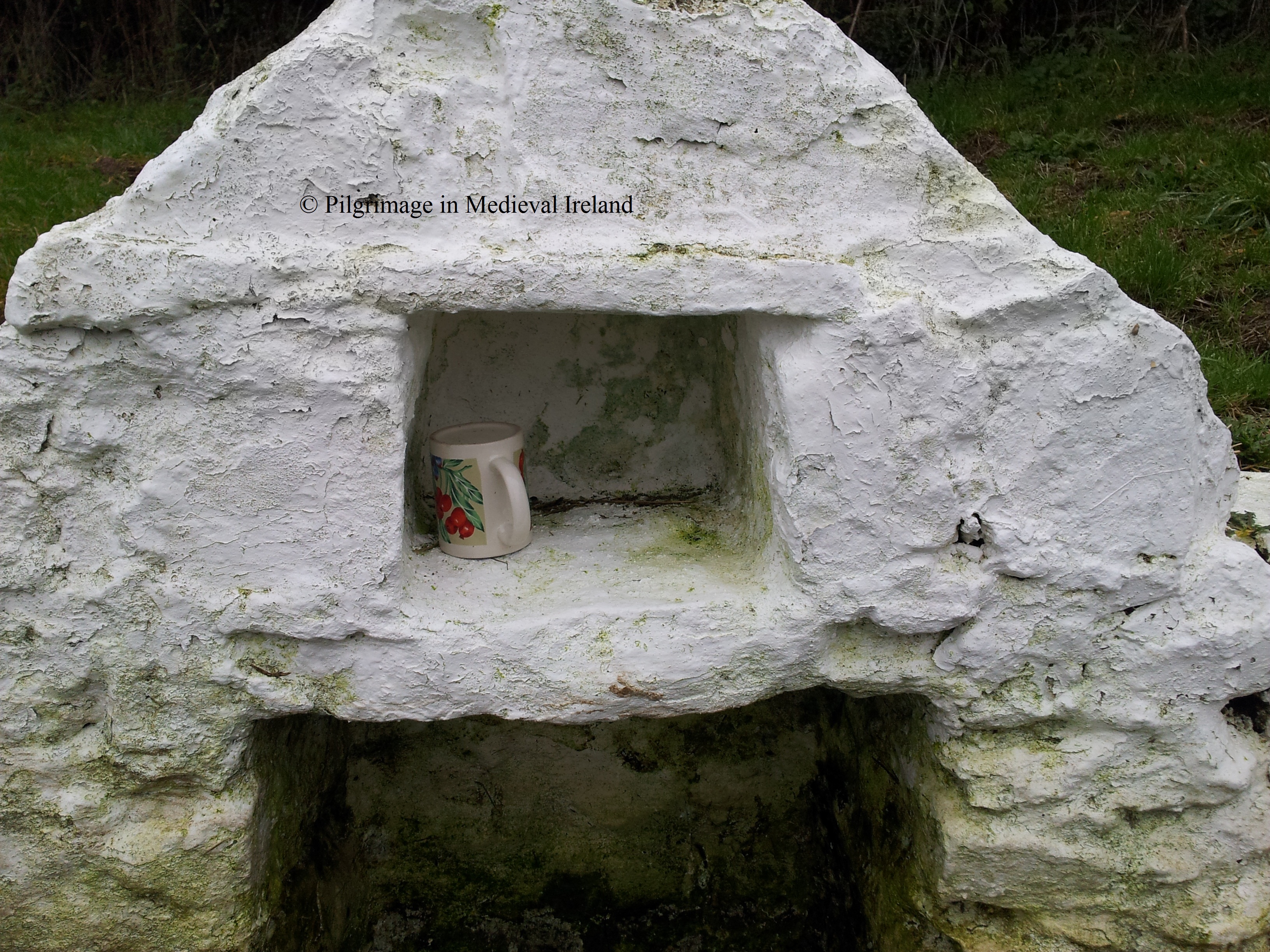
In modern times a piscina   (a shallow basin placed near the altar  of the church  used for washing the communion vessels), at the east end of the south wall of St Manchan’s church   became  a point of modern devotion. Votive offerings such as  coins, pins  and a small plastic statue of Christ are left  behind by modern pilgrims.

Piscina fille with votive offerings

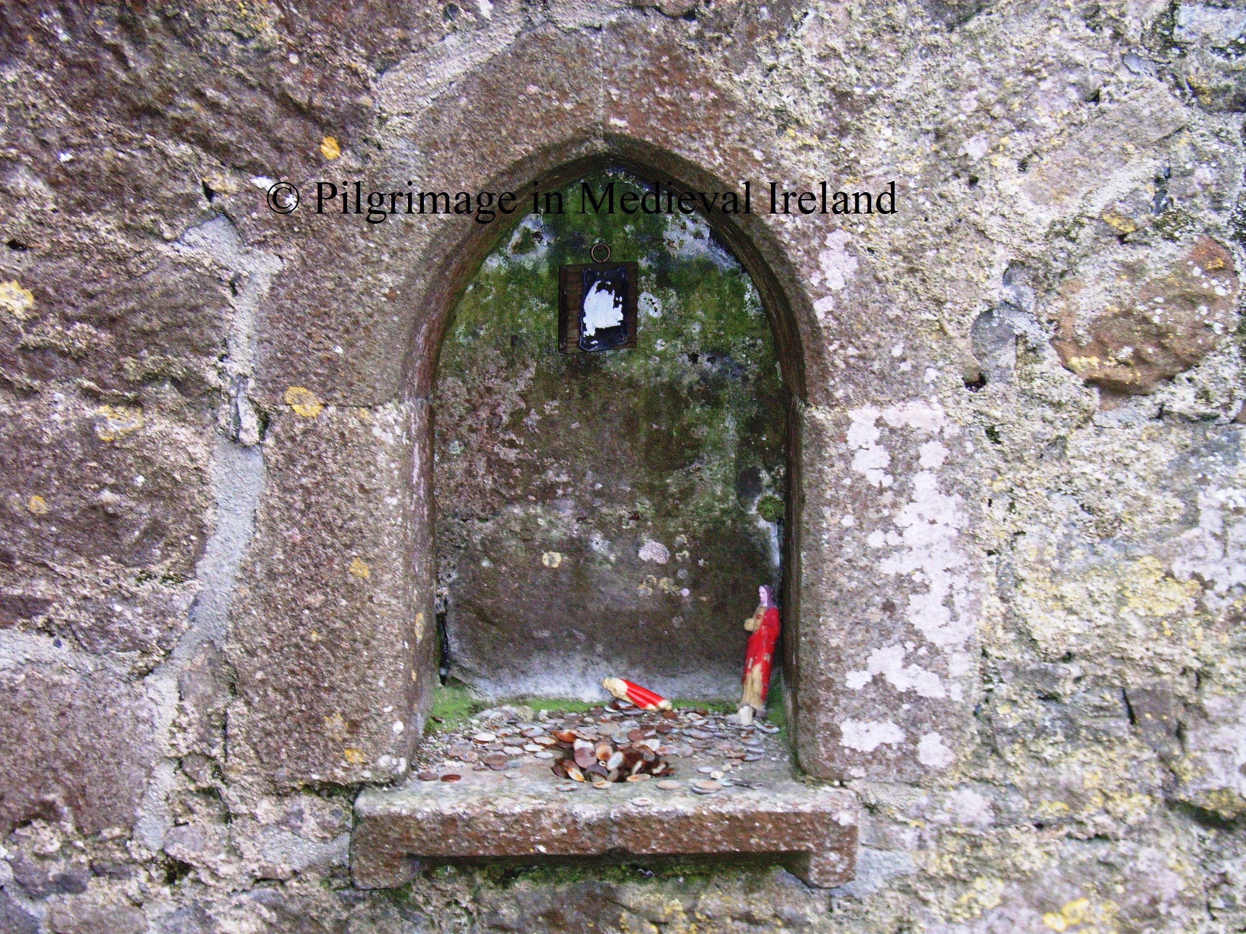
Piscina with votive offerings

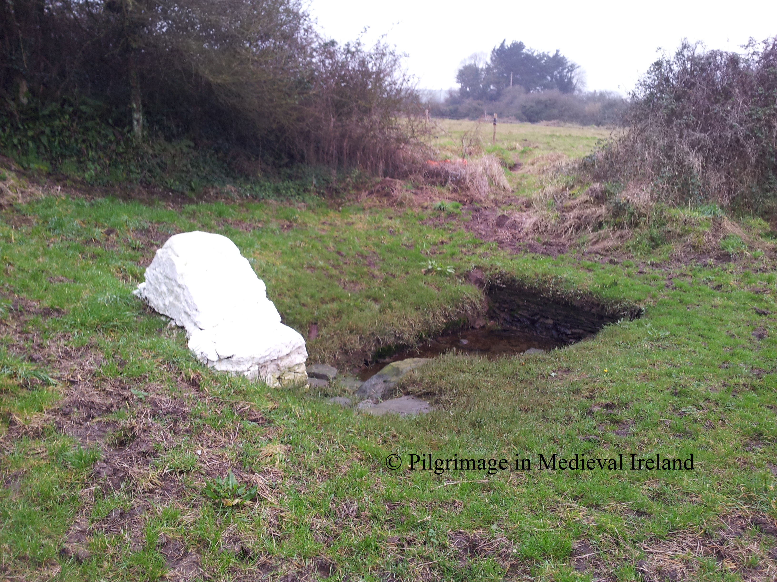
Apart from the  aforementioned reliquary, pilgrims would also have visited St Manchan’s holy well.  According to  Monahan writing in 1886  there were  three wells at the site

to which the blind, lame and persons afflicted with other chronic diseases, come on the anniversary of the patrons saint’s death.

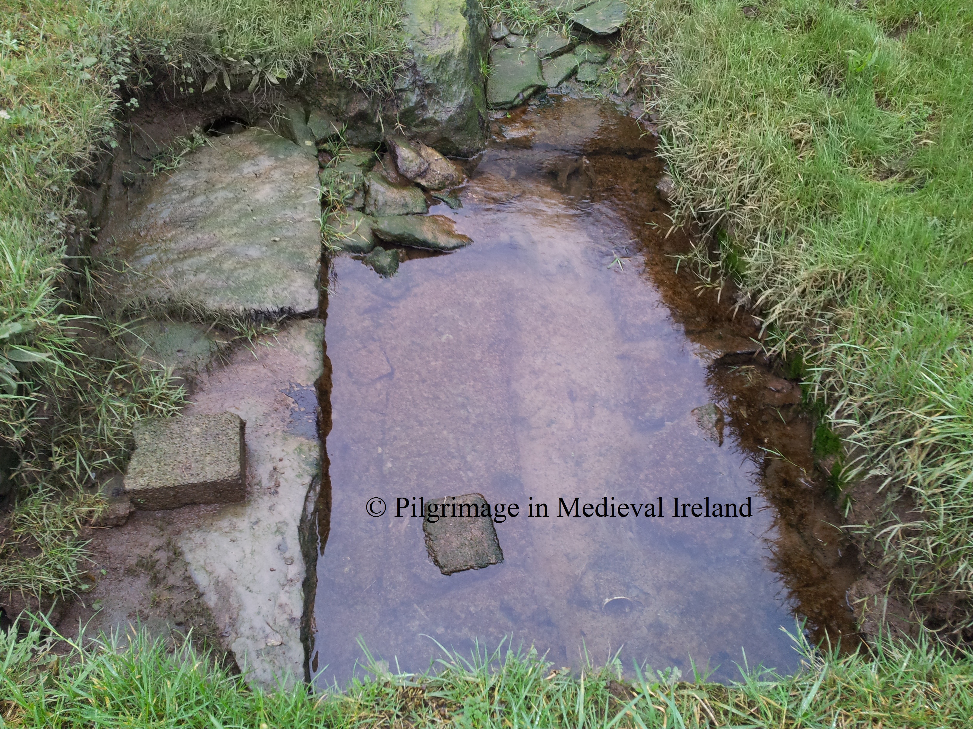
Today only one well holy well  remains, it is located close to  the main monastery beside the paved causeway  that connects the main monastic site with  St Mella’s church.  A large bullaun stone and rag tree are also associated with the well.

RIMG1628

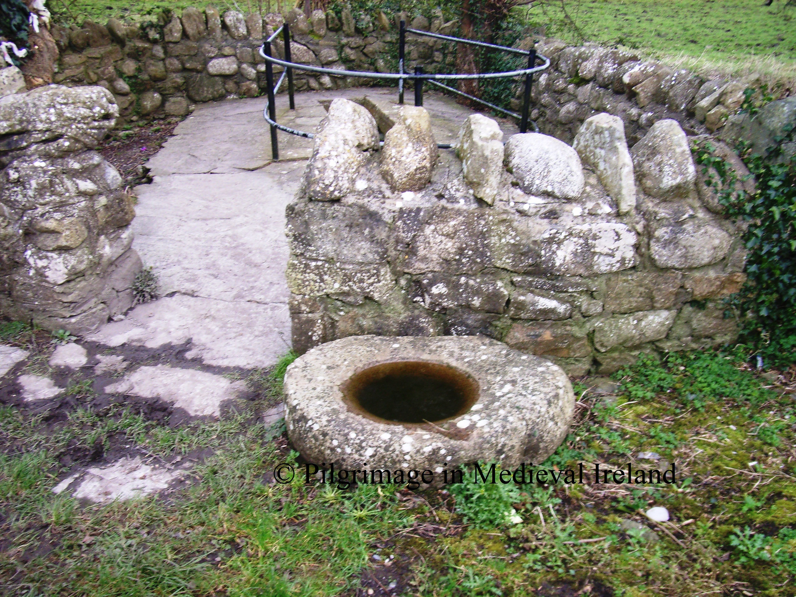
Bullaun stone at St Manchan’s holy well

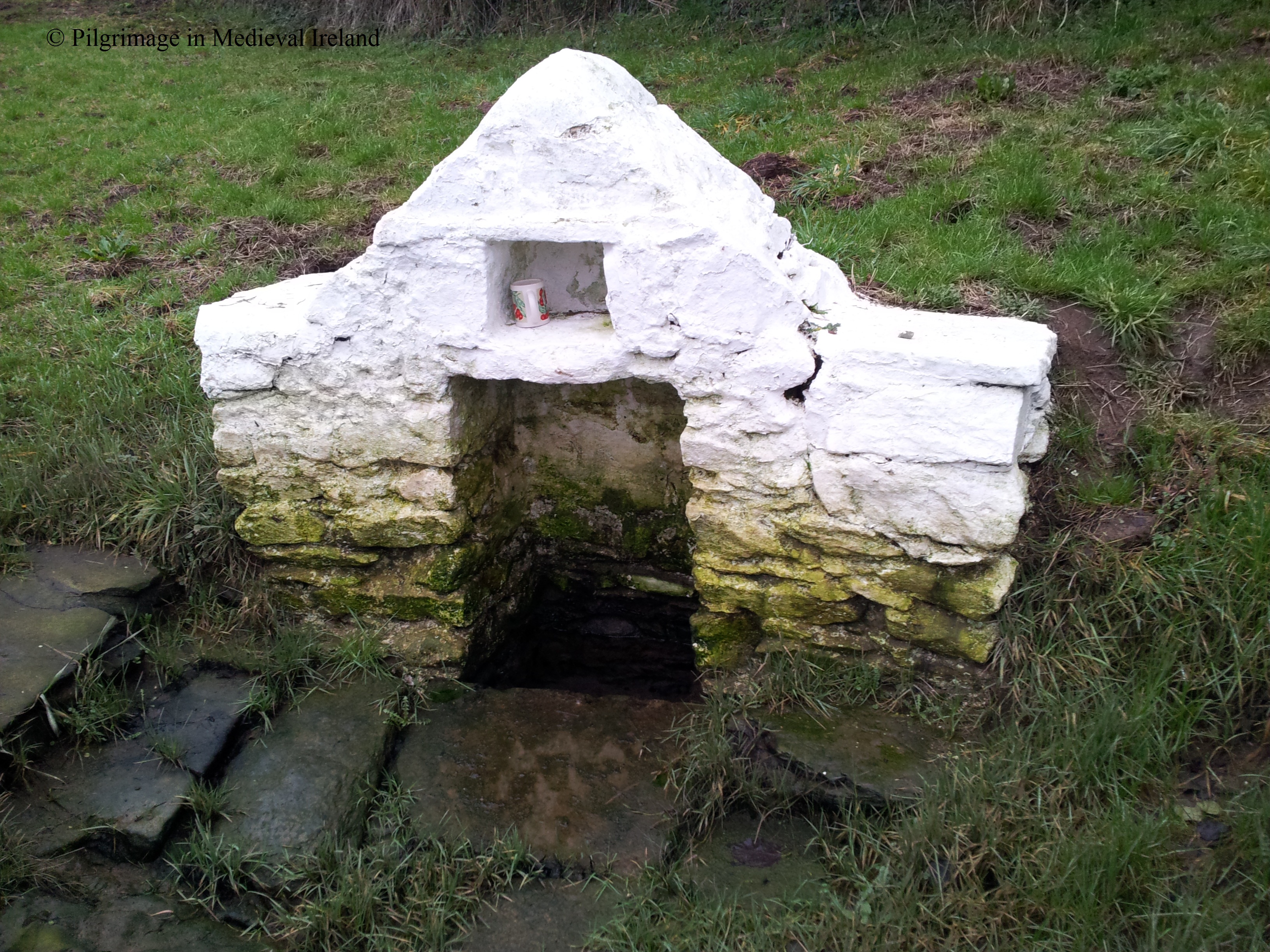
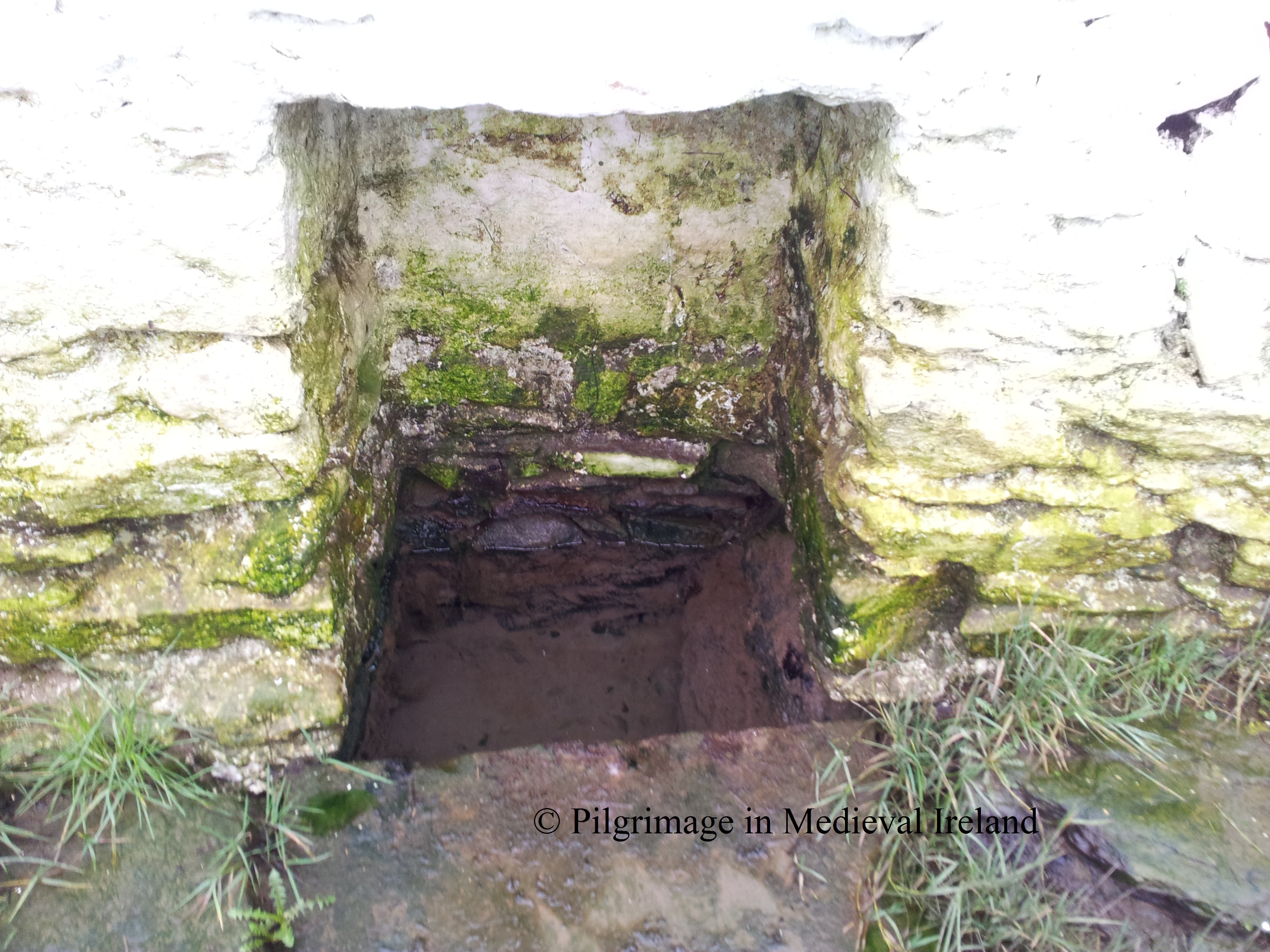
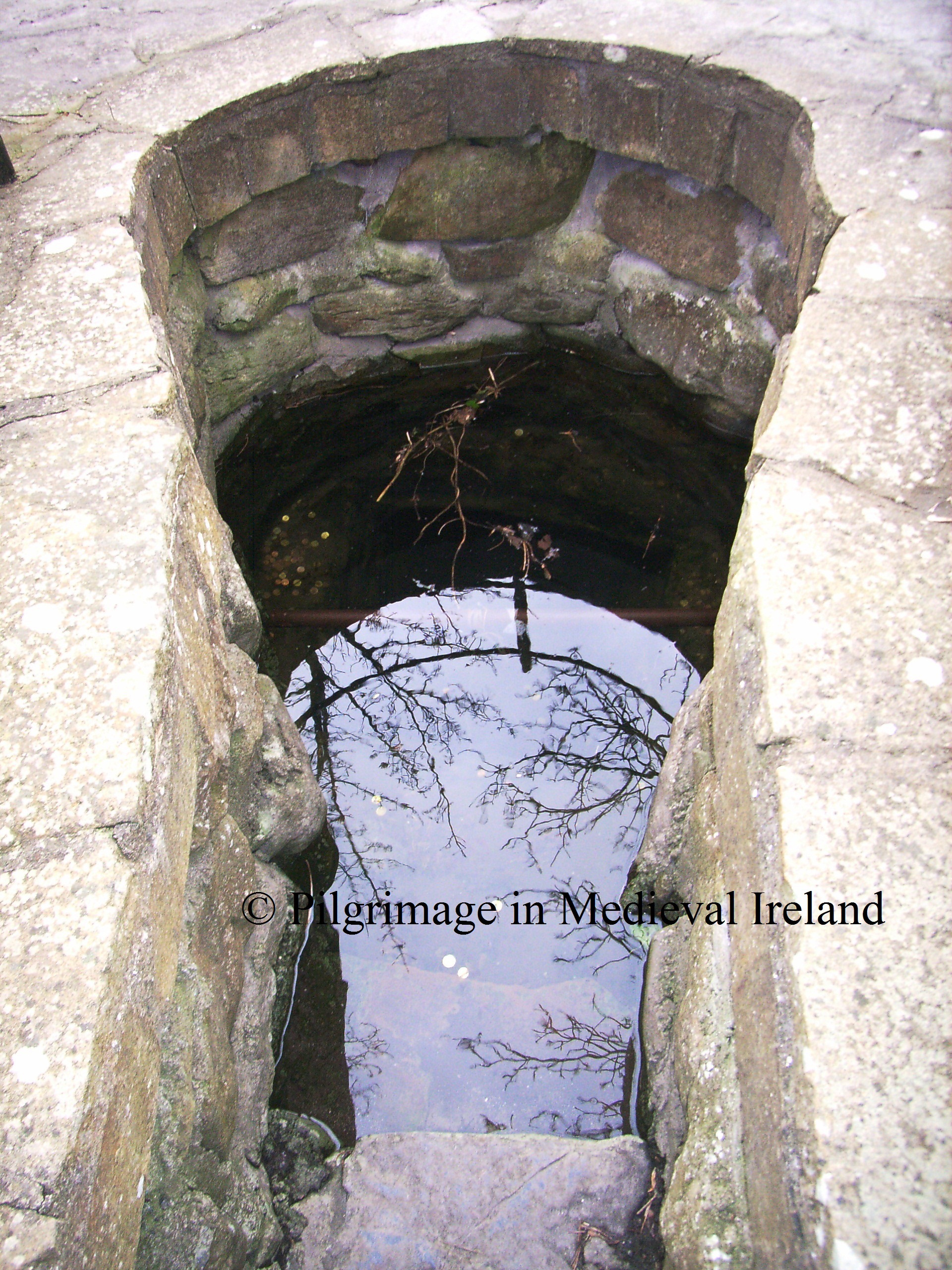
The wells at Lemanaghan may have been a focus of pre-Christian devotion and were christianised when the monastery was founded. The origin  legend for the well tells that  St Manchan struck a rock with his staff and water poured forth.  Another version of the tale states that an existing  well  was blessed by him.  Today people  visit the well throughout the year but the 24th of January the saint’s feast day still has a special appeal.  The  present  well, a natural spring,  is a product of   restoration work carried out  during the 1930s.  Four grave slabs in upright positions were revealed, set out in a cruciform pattern. The spring is enclosed by a stone wall ( key hole shaped) and accessed by series of steps. The surrounding area has been paved. The base of the well is full of coins left by modern visitors to the well.

RIMG1634

St Manchan’s well

The waters of the well are reputed to cure   nearly every ailment is cured , but particularly neuralgia, cancer and warts. The folklore suggests that for a  person to be cured they must apply water to the affected part and walk three times around the well. Beside the well is a misshapen ash tree, covered in rags, handkerchief, rosary beads etc. There is  local  tradition of taking pieces of wood to protect the home.  Similar  practices occur at other sites church as St Moling’s well at Mullinakill Co Kilkenny, where the wood of the tree beside the well is supposed to protect against fire.

RIMG1631

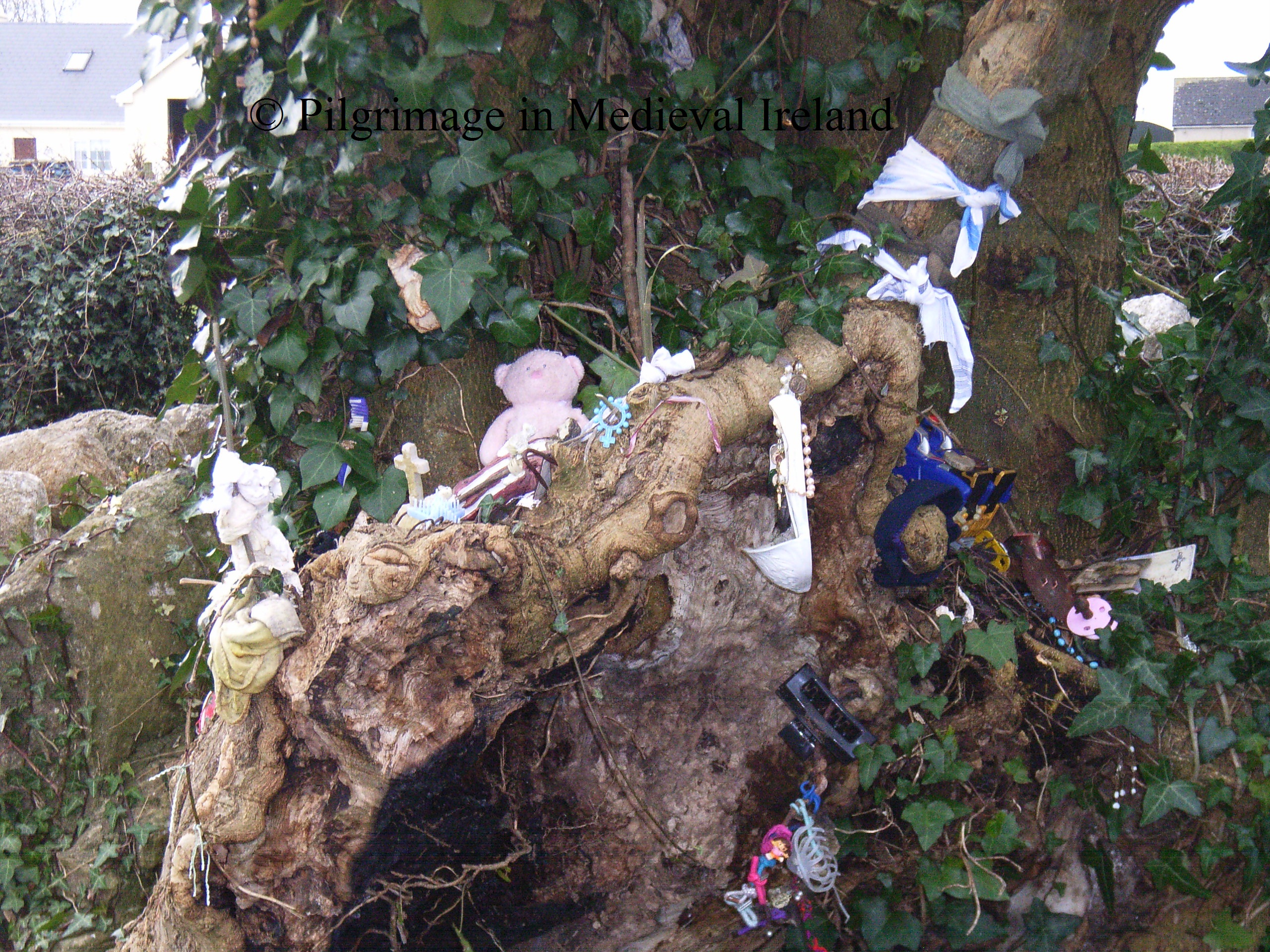
Rag tree beside St Manchan’s holy well

Like most sites we can only get a  glimpse of the medieval pilgrimage tradition  here, through the centuries  pilgrimage has continued and adapted  to the modern pilgrim landscape which focuses on the  piscina within the church and the holy well and rag tree.  I think Lemanaghan was a pilgrimage site in its own right with St Manchan attracting pilgrims  from the locality and beyond but it may have also acted as a secondary shrine for pilgrims enroute to Clonmacnoise & Durrow. If you want to find out more about the site and its history check out the sources listed below.

© Louise Nugent 2013

References

Crawford,  H. S. 1911. ‘The early slabs at Leamonaghan, King’s County’, JRSAI, xli,  151-56.

De Paor, L. 1998, ‘The Monastic ideal; a poem attributed to St. Manachan’ in Ireland and Europe,   163-169.

Fitzpatrick,  E. & O’Brien, C.  1998.  Medieval churches of County Offaly.  Dublin: Government of Ireland.

Graves, J.1874, ‘The Church and Shrine of St. Manchan’ JRSAI, xiii , 134-150.

Monahan, J. 1886. Records relating to the dioceses of Ardagh and Clonmacnoise. Dublin : M. H. Gill and son.

O’Carroll, E. 2001. The Archaeology of Leamonaghan: the Story of an Irish Bog. Dublin.

O’Riain, P. 2011. The dictionary of Early Irish Saints. Dublin : Four Courts Press.

O’Brien, C. &  Sweetman, D. P. (eds) 1997.  Archaeological Inventory of County Offaly . Dublin : Stationery Office.

http://www.logainm.ie/Viewer.aspx?text=lemanaghan&streets=yes

Medieval pilgrimage in honour of St Féichín and the ‘ Seven Wonders’ of Fore, Co Westmeath

Today is the feast day of  the  7th century St Féichín. What follows is a short account of the saints life and the history  for pilgirmage  to his shrine at Fore, Co Westmeath.

St Féichín was born in Billa in the townland of Collooney in Co Sligo and his cult is represented in the area by a number of places dedicated to him, such as  St Féichín’s well in the townland of Kilnamonagh and St Féichín’s Bed in Collonney .

Féichín  became a  student of St Nathí of Ardconry  and  went on to found  a number of churches   around Ireland such as  Fore Co. Westmeath,  Cong in Mayo, Omey & High Island in  Co Galway  and Termonfeckin Co Louth . His cult  also speard to  Scotland  and a monastery dedicated to him was founded at Arbroath (where he is known as St Vigean).   The annals tell us St Féichín died in AD 665  at Fore, having caught the  Yellow Plague, which was raging through Ireland at the time.  His Life notes that at the time of his death 300o monks resided at Fore.  It is very interesting that tradition held he was buried ar Ciarán’s church or Castlekeeran near Kells Co. Meath instead of Fore.

A Brief  Description of the Ecclesiastical Remains at Fore

This post will focus on the evidence for pilgrimage at Féichín’s  monastic site of Fore.

First edition Ordnance Survey map  of Fore

1st ed. Ordnance Survey map of Fore

Fore is located in a valley,   the archaeological  remains  consist of an early medieval church and cross located on the rocky slopes of the valley. On the valley  floor are the ruinous remains of  a  Benedictine monastery,   a Norman Motte,  fragments of a medieval town wall and  up to 14 wayside or boundary crosses scattered around the valley.

The original  early monastic site  was located  on a north facing terrace on the west side of the village.  Today all that remains are  a 10th century church  known locally as St Féíchin’s church. The church sits within a historic graveyard with a medieval cross.

Medieval cross within the graveyard at St Féichín's church

Medieval cross within the graveyard at St Féichín’s church

Close by are  the remains of  a mill  and  two holy wells  called  Tobernacogany and  Doaghfeighin.

On a terrace above the church  a 15th century tower with an  anchorite cell  that is attached to a 19th mausoleum for the Grenville-Nugent family.

View of the early monastic site at Fore

View of the early medieval  St Féichín’s church. The  19th century mausoleum is located on the terrace above St Féichín’s church.

During the 12th century the area fell into Anglo-Norman control and  a Benedictine abbey was founded on the valley floor by Hugh de Lacy. The abbey was dedicated to St Taurin and St Féichín and was a dependant of  St Taurine’s monastery at Evreux in Normandy.

Benedictine Priory at Fore

Benedictine Priory at Fore

Pilgrimage at Fore

Details of the medieval pilgrimage at Fore are very  sketchy and uncovering the pilgrimage rituals are  difficult. The earliest written evidence of pilgrimage dates to AD 1607 when Fore is listed among the 12 Irish sites  granted a plenary indulgence to the faithful, by Pope Paul V.  The indulgence related to specific days Corpus Christi and the feast of the Annunciation.  Given the popularity of the cult of St Féichín  in early medieval times,  pilgrimage at Fore  is likely to be much much earlier. The Life of St Féichín records many miracles by the saint during his life time and pilgrims likely came here  in the years following the saints death.

There is a tradition associated with the Fore  known as   the  Seven Wonders of Fore;

1. The anchorite in a stone

2. The water that will not boil

3. The monastery built on a bog

4. The mill without a stream

5. The water which flows uphill

6. The tree which will not burn

7. The stone lintel raised by the saint’s prayers.

 ‘Wonder’ number 2 & 6  relate to the holy well called  Tobernacogany . In the 19th century pilgrims performed stations here on the 20th of January the feast of St Féichín, St John’s day, the 24th of June and on St Peter’s day the 29th of June. It was recorded that following devotions the pilgrims would drive a coin edgeways into the ash tree beside the well.

Rag tree at St Féichín's well / Tobernacogany

Rag tree at Tobernacogany

It was said that the wood from this tree wouldn’t burn and the water from the well would not boil. The well itself was known to cure headaches and toothaches.

Another focus of 19th century devotion was Doaghfeighin or St Féichín’s Vat or Keen. This is a spring  which is defined by large stones arranged like a box. When I visited here the well was dry.

RIMG1405

Doaghfeighin (Feichin’s Vat)

Tradition holds that St Féichín would kneel and pray here. In the past  delicate and sick  children were immersed here in the water to obtain a cure through the  invocation of St Féichín.  A similar practice occurred at Glendalough during the 19th century when pilgrims would immerse sick children in a pool called St Kevin’s Keeve. Both wells are likely to have been a focus of   early  and later medieval devotion.

RIMG1403

Rag tree beside Doaghfeighin

The first ‘wonder’  the anchorite in a stone  likely refers to the anchorite cell attached to the 15th century tower. Within the mausoleum is  a stone which records the death of the last anchorite of Fore,  Patrick Beglan who died in 1616. This cell doesn’t appear to have been part of the  medieval or the 19th century pilgrimage stations.

Tower connected to ancohorite cell

Tower, Anchorite cell  &  Mausoleum

The third ‘wonder’ the monastery in a bog  refers not to the early monastic site which is located on the slops of the valley but the later Benedictine foundation location on the valley floor. Monasteries built on within bogs are not unusual in early medieval Ireland and Lemanaghan Co Offaly and Monaincha in North Co Tipperary are just two examples.  During the later medieval period the monastery would have been in possession of any relics associated with St Féichín.

View of benedictine Priory in the valley floor

View of Benedictine Priory in the valley floor

The ‘Wonders’ number 4 and 5,  the mill without a stream and  the water which flows uphill all refer to the   monastic mill, the ruins of which are still visible. This building stands on the original mill built by the saint.  According to local tradition the mill   was in use until 1875 when it was replaced by another mill.

RIMG1400

The mill  was  powered by an underground stream  which flows into a  now silted up triangular-shaped mill-pond.  The name Fore in Irish Fobhar means spring. The origin legend of the mill tells  that the saint decided to build a water-mill,  his carpenter scoffed at the idea of building the mill where there was no water. The saint

resorted to the lake, took his staff, flung it into the lake, which forthwith drove it against the side of the hill, which the staff at once pierced, cutting its way through the stone cliffs, drawing the waters of the lake after it, and coming out a mile distant at the exact point where the mill had been erected. And now came the punishment of the mill wright. He had gone to sleep in the mill when the saint departed to the lake. The wondrous staff, however, brought such a volume of water along with it that the mill was filled, and the sleeping millwright drowned, in punishment of his scoffing incredulity. St Fechin relaxed however, and when he had given him this severe lesson, miraculously restored him to life…

Geraldus  in his history of Ireland   written in the 12th century mentions the mill of St Féichín at Fore  and  notes  the prohibition against women entering either the churches or the mill.

RIMG1439

St Féichín’s church showing the large lintel over the doorway

‘Wonder’ number 7  refers to the enormous lintel over the door of St Féichín’s church .  Tradition records that this lintel was placed in position by the miraculous action of St Féichín himself.

According to legend when the church was being built the workmen had been labouring for hours striving to raise it, but to no avail. St. Féichín told them to go home to breakfast, and then began to  pray.  After some time spent in prayer, the saint took the stone in his arms, and without any difficulty placed it over the doorway.

With regards to  modern pilgrimage here. The rag trees beside the Tobernacogany and Doaghfeighin are covered in rags which suggests there is still a strong   local devotion to both  wells.

In 2010 a large-scale pilgrimage took place here. The Westmeath Examiner  for  2010 recorded  this  pilgrimage was to  commemorate  ‘the Jubilee Pilgrimage, and also to celebrate the year of the priesthood and as a preparation for the Eucharistic Congress in 2012′   Approximately 400 people from 9 parishes came here for this pilgrimage on May 23rd 2010.

The pilgrimage consisted of   the   Blessed Sacrament being brought in procession from Fore Church to the ruins of the Abbey,’ a trip which took over an hour’ . The   Blessed Sacrament was then carried along the walkway to the Abbey and around the Abbey. The nine parishes took turns carrying the Monstrance in procession with prayers read throughout and choirs from the nine parishes lead by Fore Choir.’ The paper also notes Local schools also prepared large banners which the children carried in the procession.

© Louise Nugent 2013

References

Ó Riain, P. 2011. A Dictionary of Irish Saints. Dublin: Four Courts Press.

Sharkey, O. 2004. Fore and Its  Ancient Buildings. Mullingar: Magpie Publications

Stokes, G. T.1892. ‘St Feichin of Fore and his monastery. JRSAI 12, 1-12.

http://www.westmeathexaminer.ie/news/roundup/articles/2010/05/27/3997364-big-turnout-for-fore-pilgrimage-of-hope-and-healing Accessed 15/01/2013.

St Bartholomew’s Holy Well Kinsalebeg, Co Waterford.

Yesterday I visited my first pilgrim site of 2013, St Batholomew’s holy well or Tobar Phárthanáin. The well is to be found  in the  parish of Kinsalebeg in Co Waterford, a short distance from the village of Pilltown and a few miles from the town of Youghal.

Location map of Holy well

Location map of St Bartholomew’s Holy Well. Image taken from Bing maps.

The well is located in a field of rough pasture on the east side of the Blackwater estuary, close to a cross roads in the townland of  Moord/Mord,  (An Móird/An Magh Ard or  “The High Plain”) about  mile south of Piltown. It’s really hard to find, I was really lucky to meet a local man who despite being in a hurry  brought me to the well.

The well is dedicated to St Bartholomew, who was one of the twelve apostles. The saints   feast day is  on the 24th of August.  There are a number of accounts of pilgrimage to the well   in the not too distant past, on this day. According to Power  writing in  1937  St. Bartholomew was traditionally held  to be the patron saint of the parish of Kinsalebeg. He also noted that his feast was kept  by local people

on the 24th of August, by visits to the ” Blessed Well” dedicated to him and that on the Sunday nearest to the feast, a public ” pattern ” is held at the well and at the adjoining village of Piltown.

From the NE the well is hidden   in a hollow  in the field close to the boundary ditch.  A short distance to the W is a small stream running into the estuary.

20130105_140215

St Batholomew’s Holy Well

The well itself consists  of a small  of a rectangular stone and mortar built superstructure,  with a triangular-shaped top.

20130105_135630

Stone built rectuangular superstructure of St Bartholomew’s well with triangular-shaped top.

There are two rectangular recesses one at the base where the water can be accessed.

Recess for access to well waters

Recess for access to well waters

The second recess sits  just above the lower opening  and below the apex of the structure. When I visited here  a modern ceramic mug  was housed within. The structure is white washed.

20130105_135655

Upper recess in well superstructure . Note the modern mug.

Stone flags act as steps to the well and  divide it from  the large rectangular trough located beside it.

20130105_135703

The larger trough is cut into the earth and  stone faced . The eastern face appears to have collapsed in but the side is still well-preserved. The west  wall is stepped with stone facing  sitting on top of three large  flags which may have acted as steps into  the trough. Perhaps in the past  pilgrims would have taken water from the smaller trough and washed their limbs   in this one.

20130105_140027

FitzGerald writing in 1856  notes that  the well

is greatly resorted to for ‘giving  rounds’ at. It is celebrated for several cures, but especially for sore eyes.

A patron at the well is mentioned in a number of sources.  The Ordnance Survey Letters of 1840, state that a pattern was last held here in 1812 on St. Bartholomew’s Day. FitzGerald in 1856 wrote ‘there is a patron held here every 24th of August’. Power writing in  1937 notes

This is a well-known holy well at which a pattern is held and “rounds” made on August 24th.

However the I.T.A. survey of 1945  noted that

up to about 50 years ago this well was held in high repute and hundreds of people came here to “make their rounds”.Of late years very few visit it’.

This may suggest the pattern was reviewed for a time after 1840 before declining in popularity  in the early 1900’s. Today the well looks like it is maintained, the white washing of the masonry   and the presence of the mug suggests its probable still used but I wonder by how many people.  Despite the grey day it is really one of the nicest wells I have visited.

20130105_135822

Nearby stream flowing out into estuary.

Rituals  performed by  pilgrims  here in the 19th century  involved the ‘making of rounds’  a tale told by Fitzgerald in 1856 suggests that the pilgrim landscape extended beyond the well.

“ when I visited it last, a couple of months ago, a very intelligent young man of the neighbourhood  pointed out to me two houses some twenty yards from the well, which he said were built on the ground that was formerly taken in by the pilgrims in their circuit of ‘rounds’ , and that to his own knowledge the parties who made the encroachments all dwindled away to nothing – none of them ever had a day’s luck afterwards.”

I haven’t had time to consult the 1st or 2nd edition OS maps but  it is interesting to note that a short distance from the well are two small cairn of  what looks like building rubble .

The well was once associated with a rag tree which  is unfortunately no longer in existence. Fitzgerald gives the following colourful description of the tree and its associated rituals.

the fine old venerable  thorns which overshadowed  it bore a most motley appearance, actually crowded with old red, blue, and green ribbons and rags, as if torn from the dresses of pilgrims, and tied up as a finale to their ‘rounds’  and prayers.

He goes on to describe a conversation with a lady that he meet at the well  who described to him the meaning of this practice at the well.

An old crone engaged in giving her ‘rounds’ told me they were tied up by each to leave all the sickness of the year behind them.

This description of the tree sounds  so very colourful and vibrant. It makes you wonder  how many other wells also had rag tree that have disappeared.

St Batholomew’s holy well or Tobar Phárthanáin is a really peaceful and lovely well. If anyone has any other information about  the well or  modern traditions associated with  it,  I’d love to hear from them.

© Louise Nugent 2013

Bibliography

FitzGerald, E. (1856-7) Proceedings – “Jottings in archaeology”, JRSAI 4, 40-49, 289-91.

I.T.A. Topographical and General Survey of County Waterford. Ireland, 1945. [on-line] http://snap.waterfordcoco.ie/collections/efolders/155321/ita_survey.pdf [accessed 4/08/2012]

O’Flanagan, M. (Compiler) (1929) Letters containing information relative to the antiquities of the county of Waterford collected during the progress of the Ordnance Survey in 1841. Typescript. Bray.

Power, P. 1937. Waterford & Lismore : a compendious history of the united dioceses. Cork: Cork University Press, 128.