Yesterday Dungarvan historian John Donovan brought me to see a holy well in Dungarvan associated with the famine. The well is located just outside the walls of the old work house now Dungarvan Community hospital in the Springmount area of Dungarvan.

The old Work House in Dungarvan now the Community Hospital.
Tradition for the areas tells that during the famine when the dead were brought from the workhouse they were carried on a cart through a gate into the wall that surrounded the workhouse. The holy well was located opposite this gateway. It was said that a local priest called Fr Twomey would come to the well each day and bless the dead with its water as they left the workhouse on their final journey to the burial ground.

Gate from Work House opposite the holy well.
These actions had such an impact on local memory that the road the well is located on is known as Fr Twomey’s road.

Fr Twomey’s Road runs along side the wall of the old Work House in Dungarvan
Another account of origin of the well is found Schools’ Folklore Collection recorded in the 1930’s. This account recalls that the priest ‘Rev Fr Toomey of the order of St Augustine was resident in this town‘. He had a vision in which the Blessed Virgin appeared to him and asked him to clean up the well and build walls around it. The same account tells that the well was a focus of pilgrimage from the mid 19th century with devotion continuing into the 20th century.
Rounds are to be made for nine days and certain prayers recited. Some people sat five Our Fathers and five Hail Marys, others recite the Rosary during the rounds, and bathe the part of the body afflicted. This well is renowned for the cure of skin trouble.
The account goes on to say the priest died in 1879 and was buried in the Friary Church in Dungarvan.
The well was not marked on the 1st ed. (1841) OS 6-inch map for the area. The wells absence from the map combined with the folklore evidence may suggest that the well came into existence around this date. The well was marked as a rectangular enclosed area along with a cross on the 2nd ed. (1905) OS 6-inch map and the 25-inch (1907) OS map and named as Father Twomey’s well.
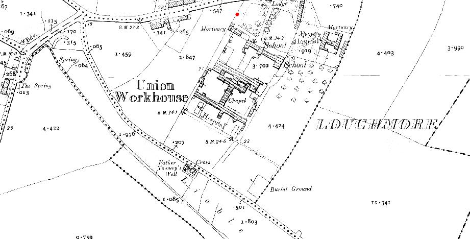
Father Twomey’s well located outside the walls of the old Work House on the 25-inch (1907) OS map
Today the well is a sad sight, devotion has long ceased the cross marked on earlier maps no longer survives. The outer wall was destroyed by a truck some years back and the council later widening the road extending the road into part of the well. What survives is covered in concrete and has a rather ugly appearance. In its current position it is hard to imagine that this was once a pilgrimage site and I couldn’t help but wonder what it looked like in times past. I am going to see if I can find out any more about the well and will keep you posted.
References
The Schools Collection, Clochar na Trócaire, Dúngarbhán (roll number 11461) Volume 0645 pages 0055-59 (logainm.ie/en/49483)

Just want to tell you how much I appreciate your blog posts. You cover things that are rarely covered anywhere else. Thanks!
Thanks so much really happy to know that you like the blog
I am trying to figure out where this is in Dungarvan – can you provide some additional directions?
Thanks,
Kay
Its just off the ring road as your heading to Cork best thing is to use bing maps and put in St Josephs hospital Dungarvan http://www.worldmapfinder.com/BingMaps/En_Europe_Ireland_Dungarvan.html the road is marked as springmount
A holy well at a workhouse would be a sad thing to start with…but what a story!