St Ailbe’s Holy Well, Emly Co Tipperary

Over the last few years, I’ve visited alot of holy wells all over around Ireland. St Ailbe’s holy well in the village of Emly Co Tipperary is one of the most interesting.

The village of Emly can trace its origins back to a monastery founded by the Pre-Patrican saint known as Ailbe. The saint’s death is recorded for the year 528 in the Irish annals.

Repose of Ailbe of Imlech Ibuir

The Annals of Ulster 528

His monastery known as Imleach Iubhair ‘the lakeside at a yew tree’ went on to become one of the most important ecclesiastical sites in Munster and in later centuries Emly became a Diocesan centre.

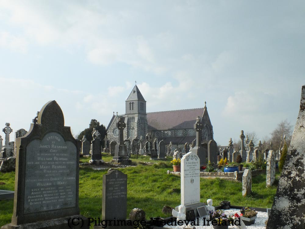
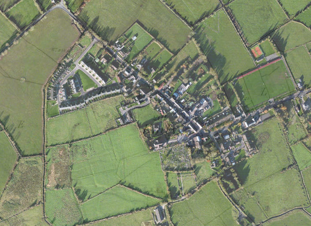
The ecclesiastical site was located at the modern Catholic church and graveyard. Unfortunately little of the early or medieval ecclesiastical remains have survived.

St Ailbe’s Catholic Church Emly

The annals provide some insight into what Emly would have looked like. In 1058 the great stone church (daimhliag) and the round tower (cloictheach) were burnt.

Imleach-Ibhair was totally burned, both Daimhliag and Cloictheach.

Annals of the Four Masters 1058

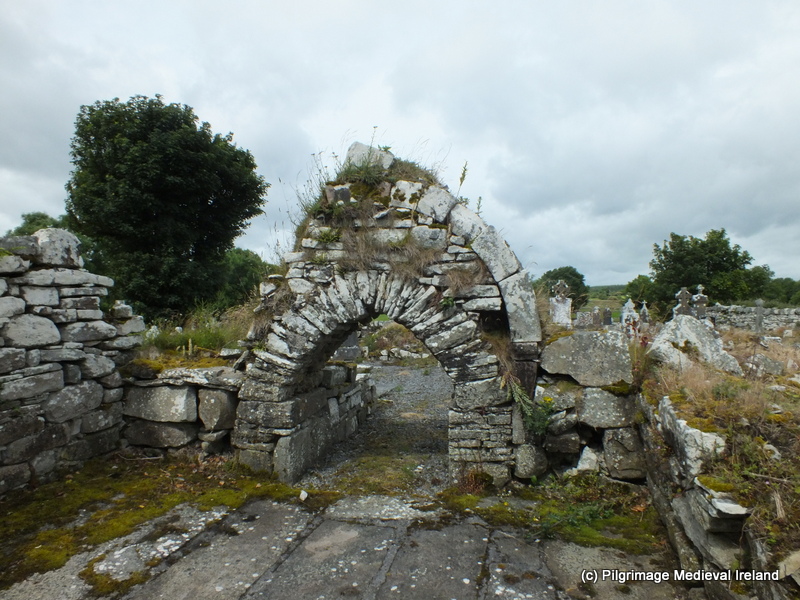
A circular enclosure surrounded the main ecclesiastical buildings. The outline of the enclosure is still preserved in the modern road and field pattern surrounding the catholic church (Farrelly 2014).

Aerial view of the village of Emly Bing Maps

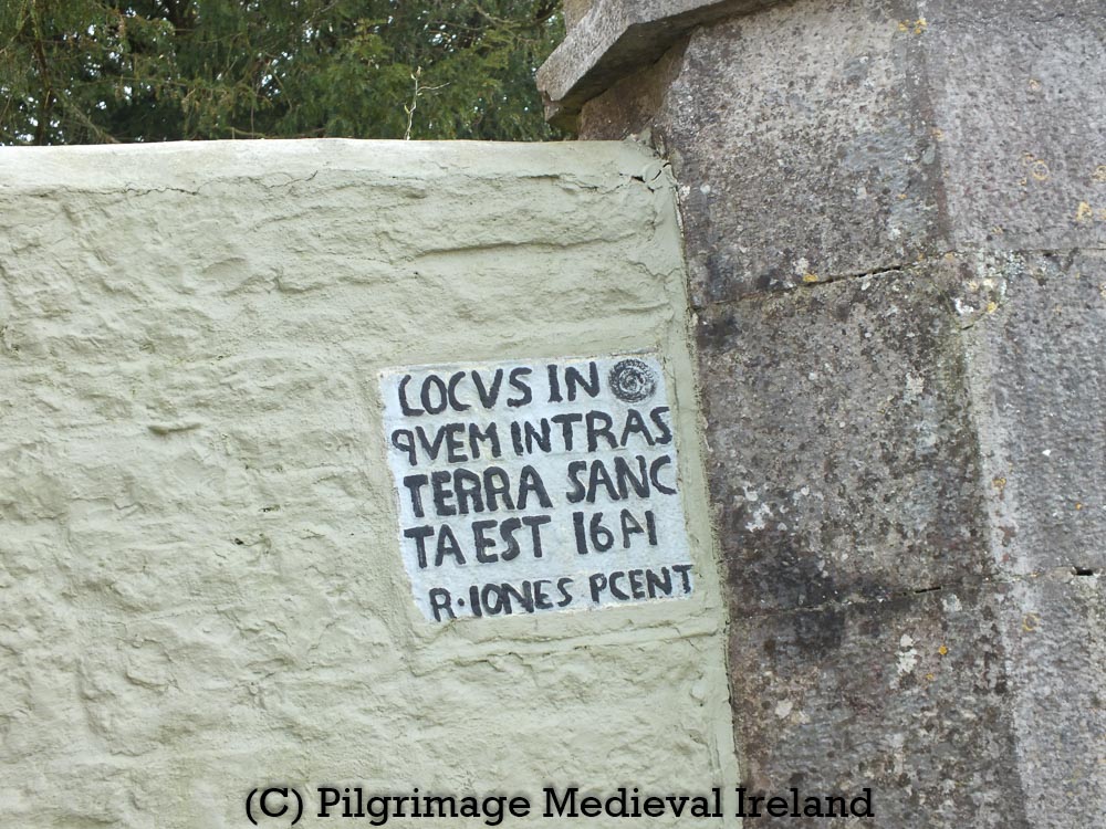
Further traces of the medieval past survive in architectural fragments incorporated into the modern graveyard wall. A stone plaque close to the main entrance to the graveyard and church which bears the inscription

LOCVS IN QVEM INTRAS TERRA SANCTA EST 1641 R. IONES PCENT

The inscription roughly translates as ‘The place wherein you enter is holy ground’ (Farrelly 2014 after pers. comm. Gerard Crotty).

Plaque with inscription LOCVS IN QVEM INTRAS TERRA SANCTA EST 1641 R. IONES PCENT’ located close to the entrance to Emly church and graveyard.

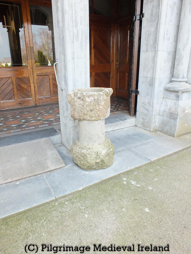
A medieval stoup, ‘consisting of bowl, shaft and base, composed of a conglomeration of sandstone, granite and quartz’ sits at the east door to the modern church (Farrelly 2014).

Medieval Stoup at eastern doorway at St Ailbe’s church Emly

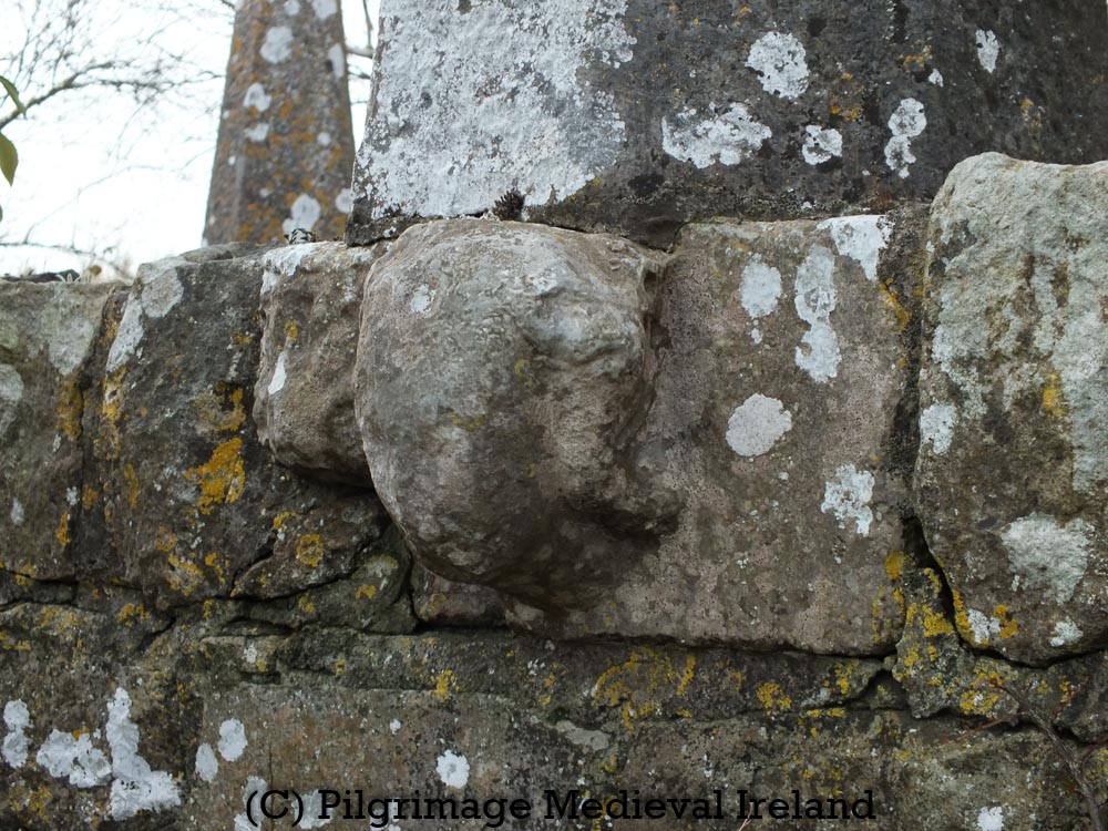
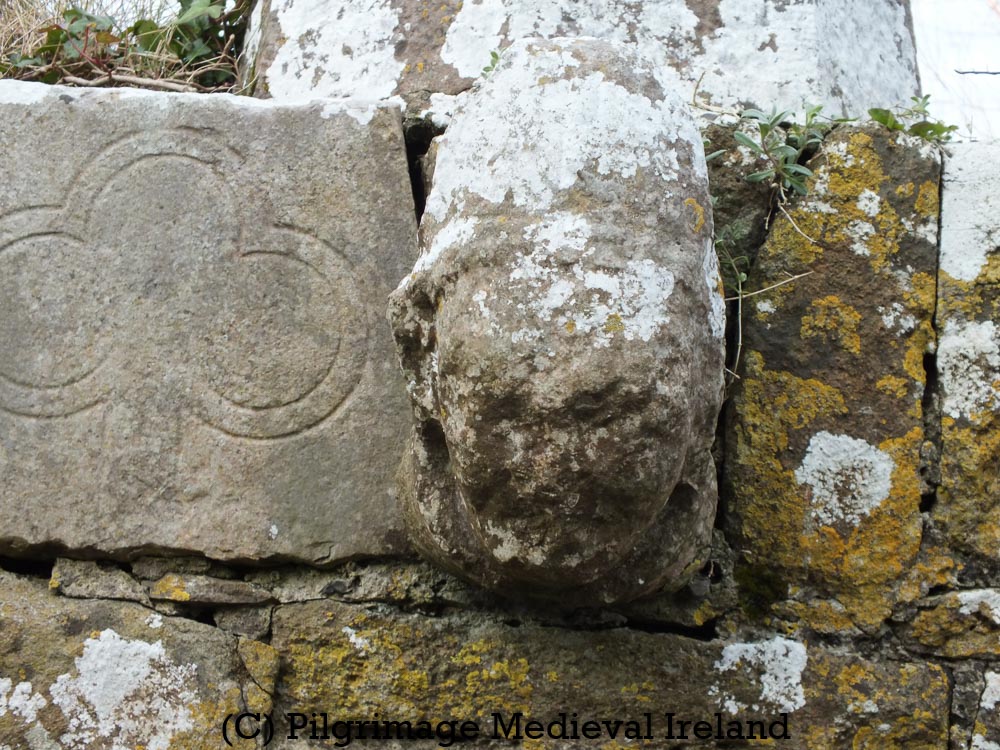
The wall to the right of the entrance to the east end of the church incorporates two carved heads from the former medieval cathedral, along with the base of a medieval graveslab. All date to the 13th/14th-century (Farrelly 2014).

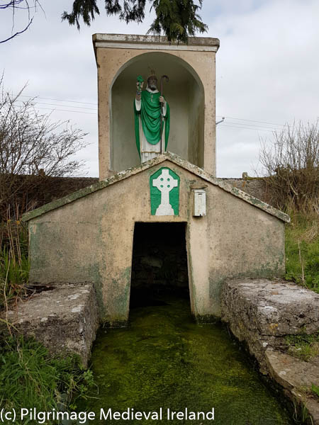
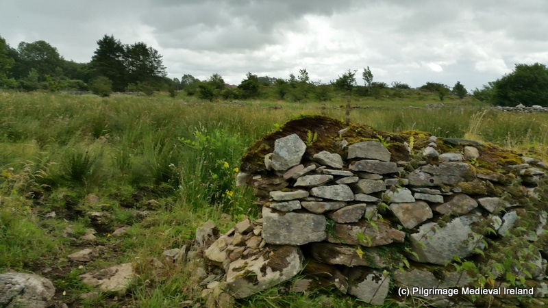
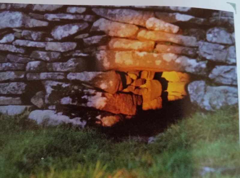
St Ailbe’s holy well can be found in the north-eastern corner of the graveyard. It was probably used as a water source for the religious community. In 1898 the well supplied the surrounding village with water.

Image of St Ailbe’s holy well 1898 from Journal of the Cork Historical and Archaeological Society, 1898, Vol. 4, No. 39 page 174.

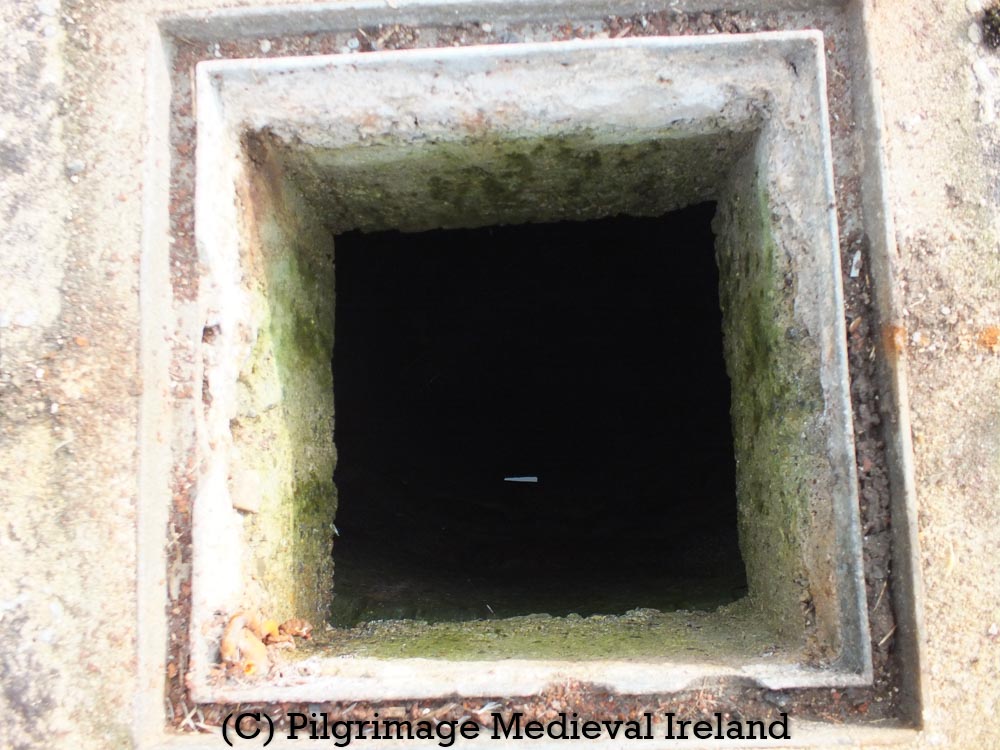
St Ailbe’s well is a very deep spring found at the base of 5m deep circular dry-stone lined shaft (internal diameter of 1.2m). The Ordnance Survey Letter for County Tipperary written in the 1840’s suggests the well was 7m deep.  The upper section of the shaft was replaced in the nineteenth century by a cut limestone surround. Accounts from the late 1890s recall that a railing surrounded the well.

St Ailbe’s holy well Emly

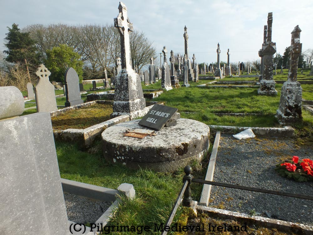
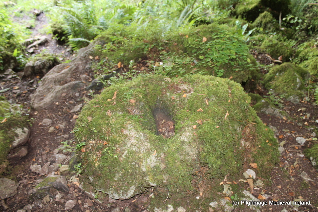
During the twentieth century the top of the well was covered by low concrete capping, incorporating a metal door/hatch. Today hatch provides a view into the interior of the well.

St Ailbe’s holy well

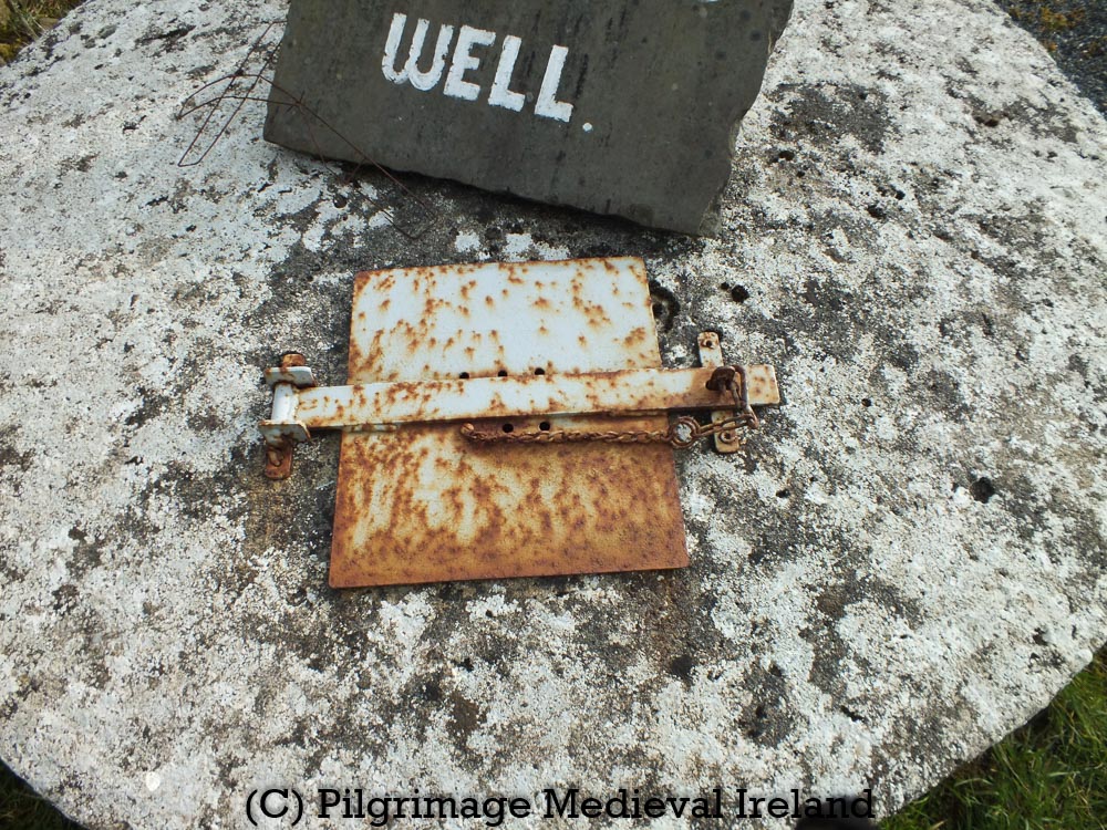
Due to the depth of the well a torch is required to see the interior in any detail . At the base of the well you can still see the water.

View into St Ailbe’s holy well

According to folklore the well was formed when

St. Ailbe jumped from the top of the hill of Knockcarron to where the well stands now and that is what caused the well to be there.

Archival Reference
The Schools’ Collection, Volume 0580, Page 013

The well is still visited by local people throughout the year but rounds are no longer performed.
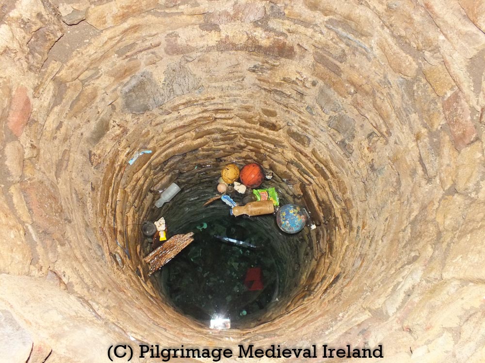
I have not come across any medieval references to pilgrimage at the well. Rounds were performed by pilgrims up to the middle of the twentieth century. Local folk memory recalls that a pattern day was held at the well on the 12th of September, the feast of St Ailbe.

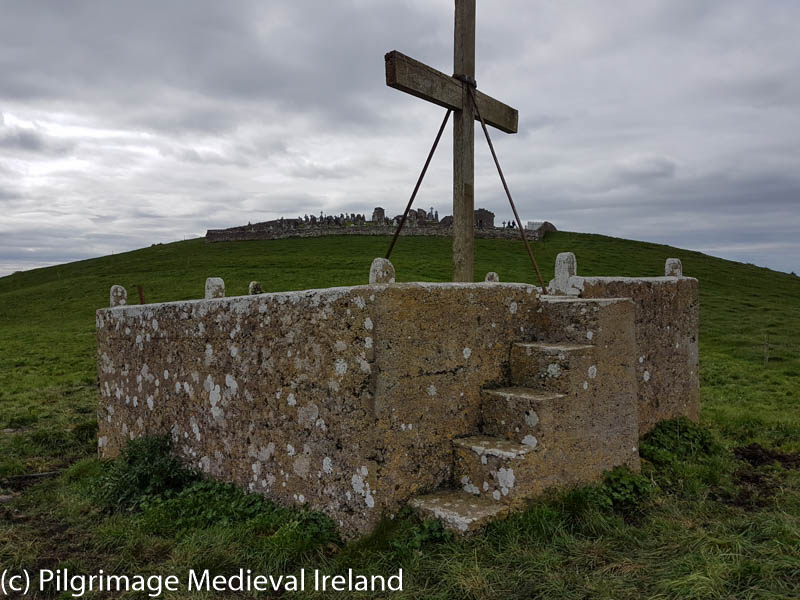
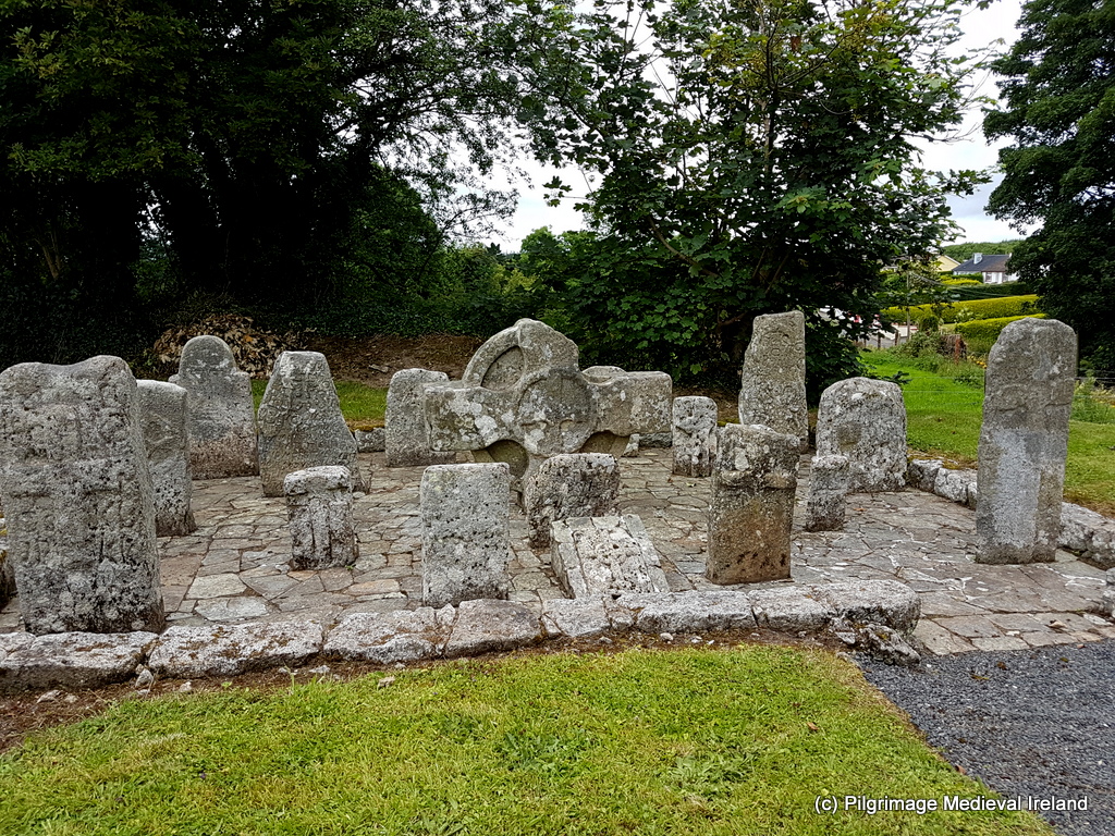
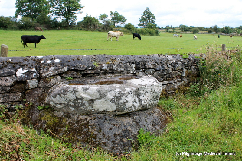
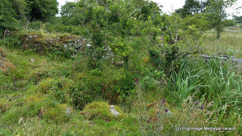
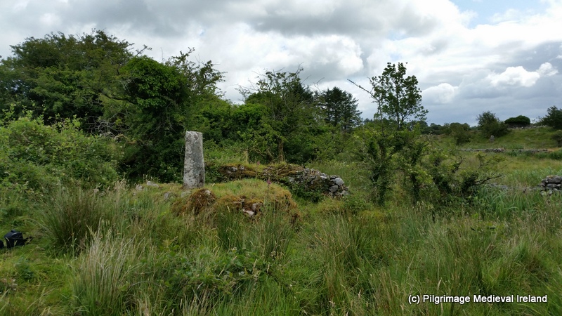
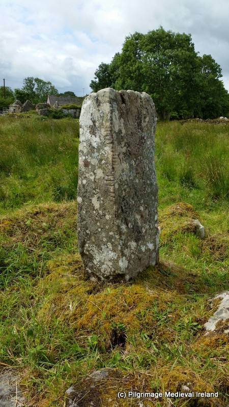
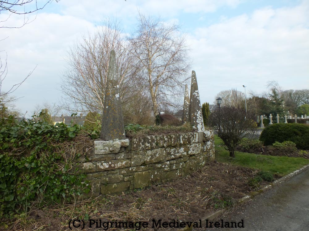
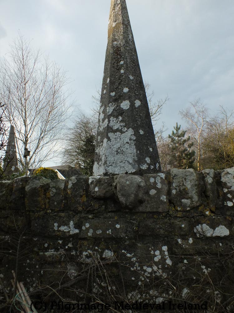
Local memory and historical sources suggest that in the past the pilgrimage rituals were focused on the holy well and an early medieval cross, known as St Ailbe’s Cross. The cross is located a short distance from the well.

St Ailbe’s Cross Emly

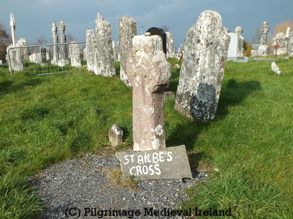
Tradition held that the cross marked the saints grave (The Schools’ Collection, Volume 0580, Page 011). The cross is made of sandstone and has an imperforate ringed cross. A small stone sits on top of the cross.

In the past pilgrims traditionally visited the holy well on the feast day of St Ailbe or within the Octave of his feast day.

In the 1930’s, pilgrims began their prayers by saying five Our Fathers and Hail Marys at the holy well. They then recited three rosaries while walking around the graveyard.  If the pilgrim visited on a day other than the feast they carried out the same prayers at the holy well but recited nine rosaries while walking clockwise around the graveyard.  Other accounts recall pilgrims walking around the well nine times and every three times they circle the well they say the rosary. They then made five rounds around the graveyard reciting the rosary on each round.

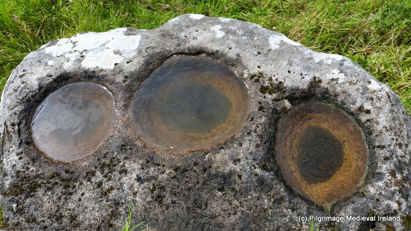
Pilgrims also visited St Ailbe’s cross. Its was tradition for all who passed the cross to make Sign of the Cross.

The Sign of the Cross is made by the people on it with three stones which are laid on top of it. Long ago the people used swear by the Holy Stone of Emly. Every time people respect it as they pass it by carving a cross on it with stones.

The Schools’ Collection, Volume 0580, Page 016

The cross was also said to cure back pain when the back was pressed against the cross and a prayer to the saint uttered. People without back pain performed the same ritual to strengthen their backs.

When a person has a pain in his back he would get it cured by putting his back against the stone and praying to St Ailbe. When a person has no pain in his back and to do the same it would strengthen his back.

The Schools’ Collection, Volume 0580, Page 016

The waters of the well are said to be a cure for rheumatism and also to repeal birds from damaging crops.

People take the water from the well to drink. When St Ailbe was young he was sent into a garden to keep birds off of it and since that people go to the well, and take water from it and sprinkle it on the corn to keep the birds away.

The Schools’ Collection, Volume 0580, Page 013

Although there are no records relating to pilgrimage during medieval times, Emly would surely have possessed relics of the saint and attracted pilgrims. Perhaps the tradition of devotion to the holy well and cross may be much older then the nineteenth century.

Bibliography

Farrelly, J. 2014. TS065-013 (Emly) https://maps.archaeology.ie/HistoricEnvironment/

Long, R. H. 1998. ‘Cashel and Emly Diocese. With a pedigree of Cellachan, king of Cashel, and an account of some other kings of Munster’ Journal of the Cork Historical and Archaeological Society, 1898, Vol. 4, No. 39, 170-­185.

O’Dwyer, M. and O’Dwyer, L. 1987. The parish of Emly: its history and heritage.

O’Flanagan, Rev. M. (Compiler) 1930 Letters containing information relative to the antiquities of the county of Tipperary collected during the progress of the Ordnance Survey in 1840. Bray.

Irish Tourist Association, ‘Emly Irish Tourist Association Report,’ Tipperary Archive, accessed November 8, 2020, http://www.tippstudiesdigital.ie/items/show/1147.

Websites

Schools Collections https://www.duchas.ie

https://www.logainm.ie

Medieval Pilgrims from West Cork

In 1472 the Irish Chieftain Finghín Ó’Driceoil (d. 1472) and his son Tadhg made a pilgrimage to the shrine of St James at Santiago de Compostela in Spain.

O’Driscoll More, Fineen, the son of Maccon, son of Maccon, son of Fineen, son of Donough God, died in his own house, after having performed the pilgrimage of St. James, and his son Teige died penitently one month after the death of his father, after having returned from the same pilgrimage.

Annals of the Four Masters 1472

Finghín resided at Baltimore castle (Dún na Séad) in the town of Baltimore Co Cork.

The castle was built by the Ó’Driceoil clan on the site of an earlier castle constructed in ‘1215 by the Anglo-Norman, Sleynie. It was the primary residence and centre of administration for the trading and piratical activities of the Ó’Driceoil family’. The castle is now restored and is a tourist attraction. It is a wonderful place to visit.

Information plaque detailing the history of Baltimore Castle

Given the Ó’Driceoil clan’s connections with trade and the sea, it is likely that Finghín and Tadhg used one of the family owned ships to sail to La Coruña. They would have continued to the shrine of St James at Santiago de Compostela on foot.

Image of medieval boats

Pilgrimage to Santiago was for many of Ireland’s medieval elite a family tradition. We know that Finghín and Tadhg were following in the footsteps of at least one family member know as the Ó’Driceoil Óg. He had made pilgrimage to Santiago de Compostela in the year 1445, but died during the return voyage from Spain.

View of the sea from Baltimore Pier

Finghín and Tadhg survived the journey to and from the shrine of St James but Finghín died ‘in his own house’ upon his return home and Tadhg died one month later. Perhaps the stresses of the journey had exacerbated underlying medical conditions.

View of the sea from Baltimore Castle

The sudden death of Finghín and Tadhg’s was no doubt a shock to the Ó’Driceoil family, they may have gained some comfort from knowing that the father and son had gained indulgences during their pilgrimage to St James shrine. It was widely believed at the time that an indulgence would have shortening the souls time in purgatory.

For anyone who wants to find out more about the medieval Irish pilgrims who travelled to the shrine of St James at Santiago de Compostela you can check out my new book Journeys of Faith Stories of Pilgrimage from Medieval Ireland

I also highly recommend the book Medieval Irish Pilgrims to Sanitago de Compostela By Bernadette Cunningham.

Pilgrimage to St Mullins Co. Carlow during the Black Death

Throughout the medieval period many people made pilgrimage in times of crisis such as personal illness, outbreaks of disease and natural disasters like drought. The Black Death was one of the biggest crisis to be faced by people during the fourteenth century in  Ireland.

The Annals of Ireland written between 1333-1349 by John Clyn, a Franciscan friar of Kilkenny, contains a chilling first hand account of the Black Death as it raged through Ireland.

The text also records a very rare account of pilgrimage to the ecclesiastical site of St Mullins whose ruins are now at the centre of a picturesque village of the same name in Co. Carlow.

Image may contain: grass, outdoor and nature

Remains of St Moling’s ecclesiastical site along side the Anglo Norman motte at St Mullins Co. Carlow ( image from SMART (St. Mullins Amenity & Recreational Tourism Group) Facebook Page.

The ecclesiastical site of St Mullins traces its history back to the seventh century, when St Moling founded a monastery on the banks of the river Barrow.  Following the saints death his monastery went on to become one of the most importance pilgrim sites in Leinster.

In the year in 1348  John Clyn recorded great numbers of pilgrims arriving at St Mullins. The pilgrims were drawn here because of St Moling reputation for healing and miracles. They hoped that by praying to the saint in the presence of his relics they might be protected from the plague.

This year, and chiefly in the months of September and October, great numbers of bishops and prelates, ecclesiastical and religious, peers and others, and in general people of both sexes, flocked together by troops to the pilgrimage and wading of the water at Tigh Moling [St Mullins] so that many thousands might be seen there together for many days; some came out of devotion, but the greater part for fear of the pestilence which raged at that time with great violence….” ( Williams 2007, 246).

The pilgrims made their prayers at St Moling’s holy well  and millrace located just outside the main monastic enclosure.  The twelfth Latin Life of  St Moling, recalls how the saint single handed dug the mill race over seven years and then consecrated ‘…by walking through it against the flood…’. The pilgrims hoped that by washing or ‘wading’ in the of the waters of the millrace and the holy well they would be protected from the plague. We do not know how the pilgrims fared in the coming months how many died or survived.


The plague spread rapidly after its arrival to Ireland.  In June of 1349 Clyn wrote that the pestilence was so contagious that those who ‘touched the dead or the sick were immediately affected themselves and died’.   Shortly after writing the description below Clyn contracted the disease and died.

Many died of boils, abscesses and pustules which erupted on the legs and in the armpits. Others died in frenzy, brought on by an affliction of the head, or vomiting blood. This amazing year was outside the usual order of things, exceptional in quite contradictory ways – abundantly fertile and yet at the same time sickly and deadly… It was very rare for just one person to die in a house, usually, husband, wife, children and servants all went the same way, the way of death… (Williams 2007, 250).

St Moling’s holy well along with the medieval millrace can still be seen in the modern landscape at St Mullins. St Moling’s holy well is still a focus of modern pilgrimage on the second Sunday of July.  If anyone who wants to find out more about the medieval pilgrimage at St Mullins check out  my new book Journeys of Faith. Stories of Pilgrimage in Medieval Ireland.

Bibliography

Nugent, Louise.  Journeys of Faith. Stories of Pilgrimage From Medieval Ireland. Dublin: Columba Books, 2020.

Williams, Bernadette. The Annals of Friar John Clyn. Dublin: Four Courts Press, 2007.

An outline of my new book ‘Journeys of Faith. Stories of Pilgrimage from Medieval Ireland’.

I am delighted to announce that my new book, Journeys of Faith. Stories of Pilgrimage from Medieval Ireland, published by Columba Books, is now available to per-order through the Columba Books website  with free shipping.

front-cover-journeysfaith-amazon

Front cover of my new book on Irish Pilgrimage Journeys of Faith. Stories of Pilgrimage from Medieval Ireland

Just to give you a taste of what the book is like. The layout follows the stages of  pilgrimage from departure, arrival at the pilgrim shrine and the return home.

Journeys of Faith FINALV2-7_page-0001

Table of Contents for Journeys of Faith

Chapter 1 explores what type of pilgrim sites existed in early and late medieval Ireland.

Chapter 2 highlights the known pilgrim destinations outside of Ireland visited by Irish pilgrims such as Canterbury and Rome.

Chapter 3 explores the many and varied reasons and  motivations that prompted Irish people to make pilgrimage such as penance – indulgences- the quest for healing.

Chapter 4  looks at the spiritual and practical  preparations made by pilgrims in advance of undertaking their pilgrimage.

Chapter 5  discusses the evidence for travel in medieval Ireland, focusing on the well known pilgrim road – Tóchar Phádraig,  along with the journeys of individual Irish pilgrims.

Chapter 6- explore the evidence for travel outside of Ireland to exotic places like Rome and Jerusalem and tells the story of the pilgrimage of  Irish Franciscan friar Simon FitzSimon who traveled to Jerusalem in the 14th-century.

Chapter 7 & 8 focus on the pilgrims arrival at their destination and teases out they interacted with relics, the graves of saints and holy statues as well as other pilgrims.

Chapter 9 the final chapter looks at the pilgrims return journey along with, the archaeological evidence for pilgrimage such as pilgrim souvenirs and pilgrim burials.

Throughout the book I  highlight many  interesting stories of Irish pilgrims who made journeys big and small across this island and overseas. Some of my favorite stories include the pilgrims who traveled to St Mullins, Co Carlow in 1348, in search of a miraculous cure for the Black Death. Or the pilgrimage of  Heneas Mac Nichaill who made pilgrimage to atone  for the murder of his son by visiting nineteen pilgrim sites around scattered across the island of  Ireland in 1543.

I think one of the best things about researching this book was visiting so many amazing Irish pilgrim sites. Those of you who follow this blog already  know I love to use photos  in my posts and I am delighted to say the book is full of  photos of  many of these special places.

This slideshow requires JavaScript.

For any one interested in purchasing Journeys of Faith follow the link to Columba Book order page

https://columbabooks.com/product/journeys-of-faith/?fbclid=IwAR1Fe6qvSmEE81l-MuANngWRASTh4Nzna2p5ElimKE0xrQqJDOcAj0WFzpA

Pilgrimage Conference- Encountering The SACRED: THE ARCHAEOLOGY AND HERITAGE OF PILGRIMAGE

Its so exciting  a conference devoted to the pilgrimage will take place in Ireland on Saturday, 5 October 2019 at The Printworks Event and Exhibition Centre in Dublin Castle.

A one-day conference Encountering the Sacred: The Archaeology and Heritage of Pilgrimage, will explore a wide range of pilgrimage topics from prehistory to the present day and have an Irish and International focus.Encountering—Logo

The conference has a great line up of speakers:

  • Professor Robin Coningham, UNESCO Chair in Archaeological Ethics and Practice in Cultural Heritage, Department of Archaeology, Durham University
  • Dr Lee Clare, German Archaeological Institute, Berlin.
  • Frank Coyne, Aegis Archaeology.
  • Dr Robert Hensey, Archaeologist.
  • Pat Holland, Archaeologist, former museum curator, and annual participant on pilgrimages across Europe.
  • Dr Małgorzata Krasnodębska-D’Aughton, Department of History, UCC.
  • Dr Louise Nugent (Archaeologist & Blogger)
  • Dr Tomás Ó Carragáin, Department of Archaeology, UCC.
  • Br Colman Ó Clabaigh, OSB, Glenstal Abbey.
  • Professor Ruth Van Dyke, Department of Anthropology, Binghamton University, New York.

Tickets are still available here from eventbrite

Encountering The Sacred: The Archaeology and Heritage of Pilgrimage conference is presented by the National Monuments Service of the Department of Culture, Heritage and the Gaeltacht in partnership with the Office of Public Works and organised by Archaeology Ireland.

Pilgrimage at Knockpatrick Co Limerick

Knockpatrick Hill is located a short distance from the town of Foynes in West Limerick. According to folklore St Patrick visited here when traveling around Co Limerick.

367

View of Knockpatrick Hill Co Limerick

The landscape includes the site of a church, a holy stone  and a  holy well, all dedicated to the saint.

knockpatrick

Knockpatrick landscape (image taken Bing Maps)


St Patrick’s Holy Well

St Patrick’s holy well is located to the west of Knockpatrick Hill in the corner of a large field.

372

St Patrick’s Holy Well Knockpatrick

The holy well is a natural spring defined by an oval dry stone wall. Some time in the last century a larger concrete structure was built over the well and the wall. The spring well’s water flow into a rectangular trough or bathing tank.

374

St Patrick’s Holy Well

A large statue of St Patrick sits in a statue niche over the doorway of the well house.

According to Ó Danachair (1955, 215) witing in the middle of the last century  large crowds came here on the 17th March. Devotion to the well has declined  and today the water in the well trough are covered in thick green algae.

Knockpatrick is only a few minutes walk from the well.

St Patrick’s Church and Graveyard

Its an easy climb to the summit of  Knockpatrick Hill. The  summit is dominated by the ruins of a late church surrounded by a historic graveyard. A modern altar and shelter are located on the west side of the graveyard.

The hill is 572 feet above sea level and has wonderful views of the surrounding countryside including the Shannon Esturary, with the exception of the view to the northeast which overlooks the Aughinish Alumina’s factory.

According to legend, St Patrick  built and consecrated the church at Knockpatrick when he visited the area in 448 AD. It was siad he blessed all  the land that he could see. Folk relating to the area  recorded in the The Schools’ Collection, for Shanagolden, Co. Limerick  also tells that St Patrick

while staying at Knockpatrick … blessed Co. Clare. He knelt down at the highest point of the hill, gazed northward across the Shannon at the County, stretched out his hands and said “My blessing over to you”. Volume 0483, Page 168

St Patrick’s stone

The ‘Suíochán Pádraig’ or St Patrick’s Seat is located on the eastern shoulder of the hill. The seat was said to be made up six stones.  Today the stones are enclosed by a concrete wall.

436

The interior  floor is covered by patches of concrete and a large wooden cross stands in the center. The six stones cant be idenified and they may be covered  by the concreted or the briars and ivy. Folklore from the 1930’s relating to the stone  notes that

There was a flat stone to be seen at the summit of Knockpatrick until about twenty years ago. On it were two hollows which bore a rough resemblance to an impression which would be made by human knees. A local tradition connects this stone with St Patricks blessing of Co. Clare – that when giving his blessing he knelt on it, and as a sign that God had heard his prayer the imprint of his knees remained on the stone. The Schools’ Collection (Shanagolden) Volume 0483, Page 168.

439

During the twentieth century  pilgrimage ritual at the site were focused on 17th of March.  Pilgrims recited three rosaries

‘one around the wall of the burial grounds, one while moving clockwise around St Patrick’s Well and the third at Suíochán Pádraig’ [St Patrick’s Seat] (http://www.limerickdioceseheritage.org).


Knockpartick is a lovely place to visit on a sunny day. Arpatrick Co Limerick  is another hilltop site assoicated with St Patick in Co Limerick a with the saint is also worth a visit.

References

The Schools’ Collection, Shanagolden, Co. Limerick (B) Volume 0483, Page 168

http://www.limerickdioceseheritage.org


St Mac Duagh’s Hermitage Co Clare


St Mac Duagh’s Hermitage is located in the townland of Keelhilla(Kinallia’Kinahulla) in the Burren Co Clare.  According to tradition, the site was chosen by St Colmán Mac Duagh as a hermitage because of its isolation and solitude. The saint lived  here as a hermit for seven years before leaving and setting up his great monastic foundation at Kilmacduagh.

img_4644

‘What a dismal and gloomy spot!’  wrote Eugene Curry when speaking of St Mac Duagh’s Hermitage.  These remarks were recorded in the Ordnance Survey Letters of Co Clare in 1839. In my experenece this description could not be more further from the truth.   I consider  St Mac Duagh’s hermitage to be a very scenic, peaceful and beautiful place.

Curry visited  St Mac Duagh’s Hermitage on the 23rd October  1839 when carrying out his survey of the antiquities of  Co Clare.  He set off from Corofin and headed across the a karst limestone landscape of the Burren. The ground he travelled over was ‘uneven surface of limestone rock‘. The experience left Curry ‘fatigued‘ mentally and physically by the time he arrived at the ‘dismal valley‘.  The hermitage is located at the base of  Slieve Carrana cliff face in the townland of Keelhilla.  It is very clear from  his writing that his spirits were low by the time he arrived

What a dismal and gloomy spot! I walked thither on the 15th October from Corofin and I never felt so fatigued after having walked for miles across that country on the uneven surface of the limestone rocks. What an enthusiastic recluse St Colman, the son of Duach must have been to have retired from the busy scenes of life to contemplate eternity and uncertainty of human fate in the dismal valley then thickly wooded and haunted by wolves!

img_4750

View of the  Burren Co Clare from the path leading to St MacDuagh’ s Hermitage

The site has little changed from the time of the Ordnance Survey with the exception of the growth of  scrub and trees surrounding  the site.


The archaeological features at the hermitage are  surrounded by a low wall composed of large moss-covered boulders.

img_4668

View of enclousure surrounding church at St Mac Duagh’s Hermitage

The most imposing remains at the site are the remains of a small church or chapel, The Ordnance Survey Letters  described the structure as

The little oratory of Mich Duach in this wild valley  through much dilapidated is still easily recognised to be a church of his time. It was very small, and only one gable and one side wall remain.

Today the church is in poor condition only the east gable stands intact, the other  walls remain in a varying state of preservation. Ní Ghabhláin (1995, 73) dates the church to  late medieval period and there is no sign of later alterations.


Above the church  is a small cave found in the cliff face. The cave was  ‘called Mac Duach’s Bed or Leaba Mhic Duach‘ as the St Comán was ‘accustomed to sleep every night‘  (Ordnance Survey Letters).


I’m not sure  you could call St Colmán a true hermit as during his  retreat from the world he was accompanied by his servant. There is a lovely story about St Colmán’s servant.

One  day his servant  complained that he was hungry and St Mac Duagh replied that God would provide.  There was a banquet at the time King Guaire’s castle in Kinvarra and at that moment  the dishes of food suddenly rose and floated out  the window. The surprised king and his men followed the dishes and were led to St Mac Duagh and his servant. But when the king’s party arrived at the hermitage  their feet became rooted to the stone and they couldn’t move.  Luckily for the king and his men, St Mac Duagh was able to perform a miracle and free them, whereupon the king was so impressed with St Mac Duagh he asked him to found the monastery of Kilmacduagh on the lowlands near Gort. While this was taking place St Mac Duagh’s servant was eating King Guaire’s food with gusto but unfortunately had grown so accustomed to the meagre diet he received in the service of St Mac Duagh that the banquet food killed him. Theses traditions are preserved to this day in the name of the track that leads to the hermitage, Bóthar na méisel, or  ‘way of the dishes’, and the nearby  ‘Grave of the Saint’s Servant’ (Jones 2006, 93).

The road  Bóthar na Méisel is still pointed out in the landscape running towards the hermitage as is the site of the servant’s grave. The bóthar is not a made road rather a distinct weathering of the limestone and  the name may possibly remember an earlier pilgrim route from the west.

map of st mac duagh

1st edition Ordnance Survey map (1842) depicting the Boher na mias and the grave of St Mac Duagh’s Servant.

An early medieval bullaun stone  is one of the earliest features at the site.


IMG_4687

Bullaun stone at St Mac Duagh’s hermitage


There are no historical records to suggest pilgrimage occured at the site during the early or late medieval period.   However pilgrim is seldom recorded during the early/late medieval period so the silence of the records cannot be seen as definitive evidence of pilgrim not taking place. St Colmán was a significant saint with a very strong cult in the region. Close to the church are two leachta (leacht singular), low,  rectangular, drystone-faced cairn.  This type of monument occurs at other early medieval ecclesiastical sites known to have been places of pilgrimage such as Innishmurray Co Sligo.  Leacht seem to have had a variety of  funtions  some may have marked a special grave, such as that of the site’s founder saint, and others may have served as a focal point for outdoor services and others were penitianal stations. We known that the leachta  at St Mac Duagh’s  were used during the 19th century  as penitiential stations. Ní Ghabhláin (1995, 73) notes that one of the leachta was built over the rubble on the medieval church suggesting that its construction may be post medieval. It could also represent the  rebuilding of an earlier structure during this period.


Westopp in the early 1900’s  recorded a number of round stone on top of one of the leachta.

we find several of these stones and a flat slab with two parallel shallow flutings (each with one end rounded), lying on the altar.


11_2_charms

Image of stones formerly located on on the leacht at St Mac Duagh Hermitage (Westropp 2000, 36).


Unfortunately the whereabouts of the stones are at present unknown but  they may have functioned in the pilgrim rituals of post medieval pilgrims. Westropp noted

St. John’s altar at Killone ‘Abbey,’ and those at Kinallia and Ross, appear to be used only as a rude rosary to keep count of the prayers and ‘rounds’ offered at these shrines.

Another focus for pilgrims to the site, at least in the 19th century if not  long before,  was  the holy well dedicated to St Colmán Mac Duagh, known  as Tobermacduagh. The well is still an active place of pilgrimage and the water is believed to cure back ache and sore eyes.

The well is a natural spring encloused by a circular wall with a gap allowing access to the water. The  gap/entrance to the well interior is covered by a large flat stone which acts as a lintel.  The well is over shadowed by a tree covered in an eclectic mix of votive offerings.


The Ordnance Survey Letter’s for Clare (1839) state

Immediately to the east of Templemacduagh at Kinallia is Tobermacduagh, at which Stations are performed and a “Pattern” held on St. Mac Duagh’s Day, said to be last day of summer, but this must be an error, as St. Colman Mac Duagh’s Day is the 3rd of February.

and that

There are also here two altars or penitential Stations at which pilgrims perform their turrises or rounds on the “Pattern Day” or on any day they wish.

This short decription suggest pilgrims circled the leachta in prayer as part of the pilgrim rituals.

Westropp (2000, 36) writing in the early  1900’s  recorded that

on the last day of summer rounds are performed at the two altars of the oratory of St Colman Mac Duagh at Kinallia.

Both  reference to pilgrimage taking place on the last day of summer may impy that it was once a Lughnasa site.

Frost (1893) in The history and topography of the county of Clare, from the earliest times to the beginning of the 18th century  records pilgrimage taking place  on the 3rd  of February.

The place is still visited by pilgrims on the Saint’s day, February 3rd.

This date coincides with the begining of Spring and the festival of Beltane. It is possible that the times of the pilgrimage changed from the site the Summer to Spring or that Frost was taking on board what the Ordnance Survey Letters had said  and changing the date to correspond their thinking.

I’ve been told  a communtiy  pilgrimage still takes place here   on the feast day of the saint 29th of October. I’m hoping to investigate this further.

The holy well is visted throughout the year. The tradition of tieing rags and other items  to the tree beside the well is pretty recent. The practice also has a destructive effect on the holy well as  people climb on the wall enclosing the well and loosen stones damaging the walls. Tony Kirby has written a very interesting report on the practive of votive offerings at the site  and you can read this report by following the links embedded here and in reference section.  The report notes other damage at the site such as graffiti carved on the church walls and on the rag tree caused by a minority of pilgrims and tourists.

As pilgrims and visitors to holy places like St Mac Duagh Hermitage we need to consider how our visits can impact the site and others like it. We should all avoid damaging walls by climbing on them, resist the urge to carve out names on stones and trees and if attaching offerings to  trees use biodegradable materials  and avoid plastic, wire etc items which could in the long-term damage the tree.


Reference

Frost, J. 1893.  The history and topography of the county of Clare, from the earliest times tot he beginning of the 18th century. Dublin, Printed for the author by Sealy, Bryers & Walker.

Jones, C. 2006. The Burren and The Aran Islands. Exploring the Archaeology. Cork. The Collins Press.

Kirby, T. 2016 VOTIVE OFFERINGS DEPOSITION AT ST COLMAN MAC DUAGH’S HERMITAGE, EAGLE’S ROCK, KEELHILLA.Prepared for the Burren/Cliffs GeoparkLIFE project March 2016

Ní Ghabhláin, S. 1995. Church and Community in Medieval Ireland: The Diocese of Kilfenora. The Journal of the Royal Society of Antiquaries of Ireland, 125, 61-84.
O’Donovan, J. &  Curry, E. 1939. The Ordnance Survey Letters of Co Clare.

Westropp, T. 188-1901. The Churches of County Clare, and the Origin of the Ecclesiastical Divisions in That County. Proceedings of the Royal Irish Academy (1889-1901), 6, 100-180. Retrieved from http://www.jstor.org/stable/20488773

Westropp, T. reprint 2000. Folklore of Clare: a folklore survey of County Clare and County Clare folk-tales and myth. Clasp Press.

Click to access rian-na-manach-a-guided-tour-of-ecclesiastical-treasures-in-co-clare-8938.pdf


Save

Save

Save

Save

Save

Pilgrimage at Clonmore Co Carlow

Clonmore, Co Carlow is located 3½ miles south of Hacketstown and 9 miles east of Tullow in the north-east corner of the county, close to the Wicklow border. The modern village developed around the site of an early medieval ecclesiastical settlement.

20130205_125721

View of St Johns Church of Ireland Church Clonmore and road that runs through the monastic site.

Clonmore was founded some time in the sixth century, by St Maodhóg also known as ‘Mogue’. The saint was a member of the Ua Dúnlaing tribe who were the  ancestors of the Uí Dhúnlainge Kings of Leinster. He is not the same as St Maodhóg of Ferns and the two are often confused because they had the same name.  Maodhóg of Clonmore was mentioned with other Leinster saints in poem attributed to St Moling as the ‘golden vessel’ (Ó’Riain, 2011 431). His feast day seems to 11th of April (ibid , 432).

Little is know about the early history of Clonmore. The deaths of abbots of Clonmore are recorded in the Annals of the Four Masters in the years  771, 877, 886, 919, 920 and 972 . The annals also record that the monastery was burned in 774, attacked by the  Vikings in 834 and 835 and in 1040 by Diarmait mac Mael-na-mBó.

The site appears to have been a place of pilgrimage during the early medieval period. An early medieval poem written by Brocán  Cráibhtheach tells that Clonmore housed a vast collection of relics of the saints of Ireland. The collection included the little finger of St Maodhóg cut from  the saint while alive at the request of Onchú a saintly relic collector who amassed a vast collection of relics of Irish saints. St Maodhóg agreed to part with his finger  on the condition Onchú’s collection of relics remained at Clonmore. Onchú was also said to have been buried here at Clonmore. His feast day was recorded as the 8th of February. Interestingly local tradition identifies the area where Onchú was supposed to be buried in Clonmore graveyard. Clonmore was also associated with St Fíonán Lobhar.

The site of Maodhóg’s monastery  is  believed to be located  on the west side of the village beside a small stream. A  modern road runs through the centre.  A historic graveyard containing a large collection of early medieval crosses is found on the south site of the road. St John’s Church of Ireland  church and  churchyard is located on the north side of the road. There are no surviving  traces of the monastic enclousre or  buildings.

St John’s church was built  c. 1812 it  is surrounded by a triangular shaped graveyard. To the west of the church is a large solid ringed granite high cross known as ‘St. Mogue’s Cross’.


Killanin & Dugnan (1967, 304) mention an ‘ancient stone tough’ in the vicinity of the cross but I on  my visit I could not find it and  I hope it has not been stolen.

The historic graveyard on the south side of the road  is a rectangular area enclosed by a wall and it  contains a large number of early medieval cross slabs.  Some of the crossslabs are set in lines among rows of 18th and 19th century gravestones.  According to Harbison (1991, 179),  in 1975 all the loose stones crosses and cross slabs were gathered up by a local work party under the supervision of the then County Engineer, Michael O’Malley, and set upright in neat rows within a small paved area enclosed by kerbing at the north-western corner of the graveyard.

376

Paved area containing early medieval cross slabs at the north-western corner of Clonmore graveyard.

The head of second high cross is found in this paved area and the shaft and base are located a few meters to the northeast. According to Ryan in the History and Antiquities of the County of Carlow local people in the 19th century believed the cross had been destroyed by Cromwell.


Harbison (1991) has identified  24 early medieval  cross slabs in the graveyard. The crosses  include Greek crosses with expanded terminals incised or sunk into the surface, Latin crosses incised and carved in relief (by far in the majority) and  4 ringed crosses.


An ogham stone is also found in the graveyard Harbison believes it to be located in its original position  and noted that

Eddie McDonald has pointed out to me that local tradition places the tomb of St Onchuo between it and the South Cross less than 2m away from it (Harbison 1991, 177).

CW009-028021- E face

Clonmore Ogham Stone/CW009-028021 image taken from http://webgis.archaeology.ie/historicenvironment/  (White 2016).

The stone has been analysised by the wonderful Oghan in 3D project who state that

Faint traces of Ogham lettering on the SE angle … much worn and clogged with lichen’. ‘[The first two strokes of] R are lost by the fracture, and the I is broken and hard to recognise’ (Macalister 1945, 18). With the naked eye alone it is difficult to be certain that any inscription survives today. On the 3D model it is possible to make out faint traces of ogham. The 3D data was analysed by Dr Thierry Daubos of the Protecting the Inscribed Stones of Ireland project in Galway in an attempt to clarify the text (3D Analysis). Unfortunately, the scores and notches are too worn for any certainty except to confirm the presence of an ogham inscription. Macalister’s E is possible but the N may be an S and his final I looks more like a consonant, possibly C, with scores to the left of the stemline. Nevertheless, Macalister’s reading is given below as certainty is no longer achievable and it is possible that the inscription was less worn when he read it.

During the 18th and early 19th century St Mogue’s (Maodhóg) holy well  was the focus of pilgrimage. The well is located a few meters from the high cross beside St Johns Church ,on the north side of the road the bisects the monastic site, Today the holy well  sits within a landscaped community prayer garden. In times past the well was the site of a pattern on the 31st of January/1st February, the same day as the feast of the saints name sake St Maodhóg of Ferns, during the 18th century.  The Ordnance Survey Name books  for Carlow written in 1839, describe the well as

a small well with a stream running therefrom. A patron used to be  held here on Saint Mogue’s day, the 1st  of February but has been discontinued  30 years past.


The Antiquities and History of Cluain-Mor-Maedhoc published in 1862

it was until recently resorted to by peasantry for miles around for the cure of many diseases, it is now nearly unknown and neglected, and suffered to choke up with grass and weeds.

The Schools Collections  in 1939 stated that

The well is resorted to at the present time for the cure of sore eyes, warts or any skin growths -even for cancer (Clonmore School The Schools’ Collection, Volume 0909, Page 165).

For cures to be affective, water was taken from the well and applied to the hurt

This has to be done on three successive Fridays according to some; others say that it may be done on any day (Clonmore School The Schools’ Collection, Volume 0909, Page 165).

The earlier descriptions of the well make no mention of a well house and a photo in the Schools Collections from the 1939  shows the well as being open and enclosed by a low stone wall with the bullaun stone known as the wart stone sitting on the side of the wall surrounding the well.

PageProxy.aspx

St Mogue’s well  taken The Schools’ Collection, Volume 0909, Page 166

Today the  well is covered by a well house and the small bullaun stone/wart stone is found within the  house ( built post 1930).  To cure warts it was said the pilgrim needed to take  from the well and pour it into the hallow of the stone and then apply to  the afflicted area (O’Toole 1933, 114; Clonmore School The Schools’ Collection, Volume 0909, Page 111).

Directly opposite the well and prayer garden in the field on the south side of the road is a large four basin bullaun stone. The stone was once located at the centre of the field but was moved  to the easten edge during land improvements and now  sits at side of stream known as Church Brook.


The stone is a large granite boulder  about 2m in lenght with three deep depression about 30cm in diameter , the fourth is  a shallow depression.

According to folklore the stone was originally located at the monastic site but following raids by the Danes( Vikings) it jumped three times.  In the first jump it landed at the site of the St Mogue’s holy well and causes the well spring up,  the stone then jumped to the castles and from here to its former location in the field.

At that time all the land around there was poor and wet but when it lighted there it said:-
“Here I will stay till the destruction of the world and I vow that his farm will turn into fertile land, the most fertile in the parish of Clonmore and no one will interfere with me, and no grass will grow over me and I will be here till the end of time”. (Clonmore School The Schools’ Collection, Volume 0909, Page 111)

Apart from the early medieval remains Clonmore also has a large Anglo-Norman Motte and a stunning 13th century castle.

363

Clonmore castle located a short distance from  the site of  Clonmore  monastery

References

Brindley, A.L. and Kilfeather, A. 1993 Archaeological Inventory of County Carlow. Dublin. Stationery Office.

McCall, J. 1862. The Antiquities and History of Cluain-Mor-Maedhoc. Dublin : O’Toole

DEPARTMENT OF FOLKLORE, U.C.D Schoolbook vol 0909, Clonmore (1939)

Harbison, P. 1991. ‘Early Christian Antiquities at Clonmore, Co. Carlow’ Proceeding of the Royal Irish Academy Vol.91 C, 177-200.

Killanin, M. & Duignan, M. 1967. The Shell guide to Ireland. London: Ebury Press.

Macalister, R.A.S. 1945 Corpus inscriptionum insularum celticarum. Dublin. Stationery Office.

O’Toole, E. 1933. ‘The Holy Wells of County ‘, Béaloideas, Iml. 4, Uimh 2 pp. 107-133.

Ordnance Survey Letters for Co Carlow. http://www.askaboutireland.ie/reading-room/digital-book-collection/digital-books-by-subject/ordnance-survey-of-irelan/

Ryan, J. 1833. The history and antiquities of the county of Carlow. Dublin: Richard Moore Tims.

White, N. 2016.  ‘CW009-028021 , Ogham Stone Clonmore’ http://webgis.archaeology.ie/historicenvironment/( accessed 24/01/2018).


A Day Trip to the Parish of Kilmovee Co Mayo

Last summer I spent a day exploring some of the archaeology sites in the parish of Kilmovee Co Mayo. Kilmovee is located a short distance from the town of Ballaghadreen in  Co Roscommon.  Local man, Tommy Horan  was kind enough to act as my guide for the day.

The parish gets its name from St Mobhí. Kilmovee or Cill Mobhí in Irish, means the church of St Mobhí. It is said he  came to the area as a missionary, continuing on the work of St Patrick.

IMG_8447

Bullaun stone known as Na Trí Umar Bheannaith in townland of Rushes

The day began in the townland of Rusheens West with a visit to one of the largest bullaun stones I have ever seen. The stone is known as Na Trí Umar Bheannaithe/The Three Holy Water Fonts.  The  bullaun stone is a large boulder with three large depressions.  It sits on a plinth against a wall at the side of a small byroad. Folklore tells that the stone was transported from Killericín and placed in its current position.

255

Bullaun stone known as Na Trí Umar Bheannaith in townland of Rusheens West

From the bullaun stone we travelled on to the site of a holy well called Tober na Bachaille/The Well of the Crozier. The holy well is located in marshy field. As the site is  on  a working farm so permission should be sought before gaining access.

205

Field where Tober na Bachaille/ The Well of the Crozier is located.

Folklore tells that when St Mobhí came to the area as a missionary he needed somewhere to baptise new converts.  Not having a suitable water source the saint struck the ground three times with his crozier and three wells sprung up on the spot.

It is thought there was originally three wells  here but today only one well is visible.  The well is very overgrown  and a small blackthorn tree  grows beside it. The well is a spring  enclosed by a low stone wall.  The location of single well is marked on the 1st ed. (1839) OS 6-inch maps which could suggest that the three springs are within the well enclosure. Unfortunately the Ordnance Survey Letters  relating to Mayo fail to mention the well.  The Folklore Commission National Schools Essays provides an origin tale for what it calls the three Blessed Wells in the parish.

St Movee’s sister was a nun and she lived in Sligo. One day she came to Kilmovee to see her brother and the church. She was passing down through Barralackey and there was a boy minding cows. He told her he would help her and he told her that the Ardeull people thought she was a witch and that they were to follow her. He said he would go with her to the church only he had a long way to bring water to his cows. She was very thankful to him and said he would never again be short of water and she — [can’t read the word] on a rock and water filled in it and is there still. In three long steps she reached the church and every step she gave a well sprang up three well in succession and these are called the ‘Blessed Wells’ (NFSC  Cloonierin 114:52).


Tober na Bachaille is no longer visited by pilgrims and as a result it has become overgrown.  Local knowledge may shed more light on the well(s) and traditions relating to pilgrimage.

View Tobar na Bachaille.

View of Tobar na Bachaille

To the north of the well is a large stone built penitential cairn or leacht. Sitting on top of the cairn is a stout Ogham Stone.

View of penitental cairn with ogham stone beside Tobar na Bachaile

View of penitential cairn with ogham stone beside Tobar na Bachaile

Macalister noted that the ogham stone, once acted as a ‘kneeling stone’ and sat on the low wall surrounding the holy well. The stone had moved to its current position by the 1940’s (Macalister 1945, 7-9).  An ogham inscription is found along one of the edges of the stone. Macalister identified this inscription as AlATTOS MAQI BR…. He also suggests that the top of the stone was deliberately cut away by a mason during the building of the wall around the well (ibid).

Ogham stone beside Tobar na Bachaile

Ogham stone beside Tobar na Bachaile

From the holy well we  traveled on to  the ruins of a medieval parish church called An Teampall Nua also known as St Patrick’s church.  Local folklore recalls that  when the church was first built it was called the ‘New Temple’.

This slideshow requires JavaScript.

All that remains of the church are the chancel and parts of the nave walls. The walls of the church have been rebuilt and incorporated architectural fragments of windows and doors.  A chancel arch still survives in relatively good condition and appears to have been remodelled in the past. The original arch was rounded and built of cut sandstone, it was later altered and filled with masonry and replaced with a smaller  to a pointed arch defined by vousoirs. The exterior of the church is surrounded by rubble masonry that likely came from the church. In 1838 the Ordnance Survey Letters for Mayo described the church as on

on the East gable of which there is a window about 6 feet and 6 inches broad. Part of side walls remain, West gable is perfect (Herity 2009, 288).

DSCF2062

The church is surrounded by a historic graveyard and mass is said here once a year.

Our day concluded with a visit to a large ringfort called  An Caiseal located in the townland of Kilcashel/Coill an Chaisil, which means ‘the wood of the stone fort’.

The ringfort is very well-preserved and is on private land so permission must be obtained before entering.  The fort   measures 30m in diameter and is constructed of a single circular wall which is 5m thick and 3m high.

View of exterior of Caiseal ringfort

View of exterior of Caiseal ringfort

The fort is entered through a formal linteled entrance.

Linteled entrance

Linteled entrance

The interior contains the ruins of two house sites and a souterrain.

379

The top of the walls are accessed from the interior via four sets of V shaped stone steps.

Stone steps in interior walls of ringfort

Another interesting feature of the fort is  a creep-way that links two internal wall-chamber within the walls.

The wall  chambers appear to be aligned to the morning sun.

For three mornings, light goes into the back of the chambers which are two meters deep and joined at the back by a six meter passage way. Each morning the new sun has moved on half a meter on the back of the wall. There is about 20meters of the back wall (of the Caiseal) that is traversed by the sun. This means that the sun shines only for about  40 days  on the back wall twice a year. This is between Winter solstice and both equinoxes…  The first  chamber was lit on the 5th of October, the Second was lit on or about the 21st of October, but due to the curvature of the wall it is still in the chamber on the 24th …

Two months later the sun will again be shining in the this chamber on the 20/21 February as the days lengthen (Mac Gabhann no date 10-11).

20160330_104123

Image of the chamber being illuminated by light (Mac Gabhann no date 10-11)

For a more detailed discussion of the archaeology of this site see the Kilcashel project website. My day in Kilmovee was a brilliant experience and  it reminded me of the  wealth of local archaeological and historical sites that are to be found within and around all Irish villages. So really you don’t need to travel very far to find wonderful historic and archaeological sites to visit.

As many of the sites we visited were on private land, permission was always obtained before going to the sites.  If anyone is interested in visiting the area please contact the Kilmovee Community & Heritage Centre, the people who work here are so helpful and will be able to help you find out if  access is possible. Contact details and opening hours can be found on the Kilmovee website  and Facebook page (see links below). The community centre also houses a wonderful Heritage Centre called ‘Cois Tine’ (beside the fire). The  centre is design is based  on a traditional Irish cottage  and holds lots of information, photographs about the parish history, archaeological sites and folklore connected to the area. I recommend a visit to the Heritage Centre  before any exploring as it is a great way to begin a trip around the parish.

If you are in the area I would also highly recommend a visit to Urlaur Abbey located just a few miles from Kilmovee. Located on the edge of Urlaur lake the Friary built circa 1432 is one of Ireland’s best kept secrets.  Its setting alone is worth a visit.

References and useful links

Herity, M. 2009 (ed) Ordnance Survey Letters of Mayo. Dublin: Fourmasters Press.

Macalister, R. A. S. 1945. Corpus Inscriptionum Insularum Celticarum,Vol I. Dublin: Stationery Office.

Mac Gabhann, S. no date. Cill Mobhí. A handbook on local history and Folklore.

NFSC  Cloonierin 114:52 after http://www.duchas.ie/en/cbes/4427915/4357560

http://www.kilcashel.com/archaeology.html

http://www.mayo-ireland.ie/en/about-mayo/archaeology/archaeology-overview.html

Save

Save

Save

Save

Save

Save

Save

Save

Save

Save

Save